
Recommended
More Related Content
What's hot
What's hot (20)
Similar to Site Plan Project : Gandhinagar, Gujarat
Similar to Site Plan Project : Gandhinagar, Gujarat (20)
Recently uploaded
Recently uploaded (20)
Site Plan Project : Gandhinagar, Gujarat
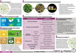
- 1. Literature study sustainableapproach Site plan studio Second year Semester 4 Siddhesh r. Kudale, s. K. srinivasa naidu § Safer streets and living places § Creating high-quality public space and taming traffic § Risk of open space becoming dead space if it is not situated on a natural desire line § Environments designed with children in mind, A safe environment for cycling. § Greening the landscape through ‘sustainable urban drainage systems’ § Facilitate public–private development partnerships (Source: SUNN, UK) § Where there is a visible energy deficit, it can be fulfilled with the help of the excess energy that is left out post-production. § This leads close to a better balanced energy consumption. § Net zero essentially means self- sustainable in variant forms, including energy, water collection, storage and use/reuse, etc. # Parameters Identified Objective(s) 1 Land Use/ Utilisation Optimal Division of Uses Management of mixed use 2 Transport and Accessibility Reduced automobile dependency Shorter Trip lengths Improve connectivity Innovative transport design 3 Resource Management Air Quality Reduced pollution Water Conservation & Optimum usage Energy Efficiency Optimum usage Construction Green Buildings 4 Infrastructure Solid Waste Waste minimisation Sewage Sewage Management Drainage Storm Water Collection and use 5 Disaster Management Risk Mitigation 6 Urban Design Developing the gamtal character 7 Tourism Encouraging Tourism in the area Sustainability is often termed as the avoidance of depletion of natural resources in order to maintain an ecological balance in the environs. Sustainable development for us would mean focussing on smaller steps to achieve a bigger goal of conserving the necessary life-essential resources for future human consumption, equitable use and life sustenance through appropriate physical planning. what is sustainability? Sustainability means the ability of meeting our needs at the same time also without compromising the ability of the future generations to meet theirs. Impact areas of sustainable development International development goals governing sustainable development Identified parameters that directly affect sustainable development Key characteristics of sustainable urban neighbourhoods The net zero approach for development of sustainable urban housing and neighbourhoods § Make cities and human settlements inclusive, safe, resilient, and sustainable. (SDG 11) § To integrate the principles of sustainable development into policies and programmes, and reverse the depletion of environmental resources. (Source: UN-SDGs and MDGs) HOW DO WE SEE sustainability?
- 2. Gandhinagar G U J A r a t GIFT CITY G U D A Key map LAND USE Distribution Connected greens:environmental sustainability Land use Area Percentage Commercial 64 HA 32% Mixed use 61 ha 30% PSP 2 ha 1% Open spaces 47 ha 23% Circulation 28 ha 14% Total 202 ha 100% (Source: GIFT Website) Table 2.1: Land-use Distribution in GIFT City (Source: GIFT Website) (Source: GIFT Website) Table 2.2: Building-use Distribution in GIFT City (Source: GIFT Website) Building use Area Percentage Commercial 492 ha 60% Residential 204 ha 23% Hotel 19 ha 2% Retail 37 ha 5% Public 84 ha 9% Recreation 9 ha 1% Total 845 ha 100% Parameter Particular Site area 202 ha Total Built up area 1319 ha Aboveground Total built up area 845 ha Floor space index 3.65 Green belt 60 ha Estimated pop. 50,000 persons Floating population 3,50,000 persons Gross density 247 pph Planning considerations Sustainable practices in infrastructure planning POWER GENERATION and supply § Indoor Substation: Gas Insulated Switchgears (GIS) substation for sub-transmission and distribution and Compact substation (CSS) in building. § Total Power Requirement- 750 MVA § Emergency Power generation (Gas Based) - 200 MW § Green Power Solid waste management techniques § Waste is thrown into a disposal chute. § Computer controlled access. § Waste sucked through pipes at speed of 90 kmph § Treatment through futuristic plasma gasification or Plasma Arc Waste Destruction System (PAWDS). § Centralised Solid Waste Management System that does not use non sustainable methods like landfills or dumping grounds that simply accumulate more and more waste. Water supply and treatment process CASE study: GIFTCITY sustainableapproach Site plan studio Second year Semester 4 Siddhesh r. Kudale, s. K. srinivasa naidu (Source: GIFT Website) A PAWDS Gasifier
- 3. SITE ANALYSIS sustainableapproach Site plan studio Second year Semester 4 Siddhesh r. Kudale, s. K. srinivasa naidu Gandhinagar G U J A r a t G U D A Key map Randesan RANDESAN URJANAGAR 2 RAYSAN S A B A R M A T I R I V E R SHRI VERAI MATA MANDIR RANDESAN MAHADEV MANDIR SHAHPUR GANDHINAGAR BYPASS ROAD DHOLAKUVA CIRCLE SMVS SWAMINARAYAN DHAM BAPS SWAMINARAYAN PETROL PUMP RAYSAN ROAD ORIENTAL BANK SA BA RM ATI RIV ER RANDESAN ROAD DHOLAKUVA INFOCITY G A N D H IN A G A R -A H M E D A B A D R O A D Site indicating wind, slope, and sun directions; existing green cover and transportation network Parameter Particular Site area 420 Hectares Population 15,082 Persons Annual Rainfall 803.4 mm Current Circulation 14.3% Existing Green Cover 23% Governing Town Planning Schemes TPS 4, TPS 5 and TPS 22 Current Built Up 12% Predominant Income Class MIG Planning considerations Existing housing typology observed Residential Bungalows Residential and Mixed Use Apartments Other climatic considerations § The average annual rainfall Gandhinagar faces is 746 mm. § Additional water requirement is there for any population that can in-migrate to this area. § Average wind speed is 24 kilometres per hour, going up to a maximum of 32 kmph in peak monsoon months. R A N D E S A N
- 4. DESIGN brief sustainableapproach Site plan studio Second year Semester 4 Siddhesh r. Kudale, s. K. srinivasa naidu § To subdivide and zone the site area into various use categories by the sustainable approach of land-use-planning. § Making the building blocks self sustainable and keeping in mind the net zero approach. § Appropriate allotment of amenities and facilities to accommodate the projected population in the site area. Study of applicable framework and policies Proposal based on DCRs followed and approach decided Curtail and amend the proposal for refinement Feedback & reconfiguration of proposed layout Literature review and case studies AIM Conserving necessary life- essential resources for future human utility, equitable use and life sustenance through good site planning. Hence applying the net zero development typology and sustainable approach for site planning objectives methodology WORKPLACE PUBLIC HOSPITAL PARK CINEMA THEATRE, MULTIPLEX CLINIC DAILY SHOPPING < 5 minutes 5-10 minutes > 10 minutes Approach to pedestrian sustainability Approach to environmental sustainability Approach to net zero development § Maximization of Green Space is the most prominent goal of environmental sustainability. § Reduction of carbon footprint and reduction in reliance on non-renewable sources of energy including coal, firewood, petroleum, etc. Approach to sustainable transit § Availability of multiple modes, like Bicycles, Autorickshaws, E-rickshaws, App-based cab services, Feeder Buses, etc. § Making all public modes of transit accessible for PwDs, and pedestrians alike. § Route optimization to minimize trips lengths. § Integration of multiple modes of transport. § Pedestrian centered approach also reduces dependency on fuel based transit options due to natural proximity between land uses. PawdsSolid waste management technique Mandatory Rain water harvesting Sewage conversion to bio-cng for fuel Wastewater treatment using dewats Solar and wind energy harvesting a smart decentralized approach to sustainable infrastructure planning
- 5. Sheet: 1 File: /Users/siddhesh/Downloads/contours_2m-Model 11.pdf Missing or invalid reference CONCEPT EVOLUTION sustainableapproach Site plan studio Second year Semester 4 Siddhesh r. Kudale, s. K. srinivasa naidu DIAGRAMMATIC REPRESENTATION OF CONCEPT EVOLUTION SCALES OF DEVELOPMENT SECTORS NEIGHBOURHOODS CLUSTERS Stage - 1 Stage - 2 Stage - 3 Stage - 5 Stage - 4 Stage - 6 Proposed circulation network pattern layout Gandhinagar G U J A r a t G U D A Key map Randesan Central ideas that shaped the design R A N D E S A N § Route for feeder bus movement to be aligned in a way that it supplies to all residential zones. § Car Free zoning around Metro stations. § The model of scaleable development, viz. Sector, Neighbourhood, Clusters, etc.
- 6. Sheet: 1 File: /Users/siddhesh/Downloads/contours_2m-Model 11.pdf Missing or invalid reference LAND USE AND densities sustainableapproach Site plan studio Second year Semester 4 Siddhesh r. Kudale, s. K. srinivasa naidu Land Use Area Percentage Residential 55.4 Ha 18.5% Circulation 68 Ha 16.1% Commercial 67 Ha 16% Transit Housing 64 Ha 15.2% Recreational 23.2 Ha 5.5% Mixed Use 2 51.1 Ha 12.2% Open Spaces 29 Ha 6.9% Randesan Gamtal 26 Ha 6.2% PSP 19 Ha 4.5% Riverfront 13.3 Ha 3.2% Mixed Use 1 5 Ha 1.2% Total 420 Ha 100% Scale R:F::1:4000 40 0 40 80 120 160 200 240 280 M Parameter Quantity Minimum Required Density 100 PPH Population 63,000-1,00,800 Gross Density 150-240 PPH PROPOSED land use plan for Randesan using the sustainable approach Land use break up in the proposed design Projected Population and density details Randesan Gamtal Randesan MRTS Station BAPS Swaminarayan Vidyamandir Girls Boarding School Dholeshvar Mahadev Mandir Sabarmati River Dholakuva MRTS Station Raysan MRTS Station TPS 4 TPS 4 TPS 4 TPS 4 TPS 4 Raysan Gamtal Policy of customized housing typology based on walkable distance from mrts stations 200 meters 4 0 0 m e t e r s a l o n g m a j o r p a t h w a y MRTS Station Car-free zone/ Transit housing (CFZ-1) MRTS Station Mixed use Precinct Mixed Use zone (CFZ-2) TOZ regulated up to normal extent (CFZ-3) § The minimum density required to sustain a feeder bus network in the area is 100 to 240 persons per hectare. § Car free zoning is similar to Transit Oriented Development; but the norms and policies given by us are completely different than that of standard TOZ regulations.
- 7. POLICy details sustainableapproach Site plan studio Second year Semester 4 Siddhesh r. Kudale, s. K. srinivasa naidu FSI regulations for different zones 2 1.8 1.8 0.5 0.7 0.45 0 0.5 1 1.5 2 2.5 3 CFZ 1 CFZ 2 CFZ 3 Free FSI Chargeable FSI 2.25 2.5 2.5 Vehicular permissibility in different zones Zone Ped 2W 3W Cab Car Bus Trucks Mini Big CFZ 1 CFZ 2 CFZ 3 Freely Permitted Moderately Permitted Not Permitted TREE POLICY AND GREEN COVER FRAMEWORK regarding infrastructure facilities = = 100:416 humans to trees ratio in Gandhinagar. A planting of a minimum of 3 trees per HH/DU to be mandatory. § Environmental sustainability should be ensured through increment of green cover wherever and however possible, through whatever means. mixed use development Mixed use is urged as it reduces the length of pedestrian & vehicular trips. Parameter Space Requirement Provision Bracket Target Population Water Supply Overhead Storage tank Per Block 100-200 persons RWH System Underground Storage tank Per Block -do- Solar Panels Open Terraces Per Block -do- Wind Turbine Open Terraces Per Block -do- DEWATS 50 sqm on ground Per Plot 1000-1200 persons Biogas Plant 25 sqm on ground Per Pocket 10,000 persons PAWDS 25-65 sqm on ground Per Pocket 10,000 persons § A reserved common green space is mandatory to be provided that shall accommodate plot and pocket level decentralized infrastructure, viz. plot and neighborhood level greens respectively. § Terraces that are not under solar, wind or water harvesting would be exceptions only in cases of terrace greens, commercial terraces, and temporarily covered terraces. § Power grid network should be laid in such a way that both horizontal and vertical transfer of excess energy is possible. RESTRICTIONS ON BASEMENT DEVELOPMENT LIST OF TYPOLOGIES APPLICABLE IN CAR FREE ZONING Typology Max. DUs per floor CFZ 1 CFZ 2 CFZ 3 Hostels 25 Rented Housing 4 Cooperative Society 4 Mixed Use Housing 4 Office Apartments 4 Townships (Non-industrial) 6 Studio Apartments 6 Government Housing N/A Residential Bungalows N/A Freely Permitted Not Permitted § No basements shall be developed, due to vulnerability in seismic zone III. § Mandatory safety measures should be implemented in all buildings. Base Isolators
- 8. RANDESAN URJANAGAR 2 RAYSAN S A B A R M A T I R I V E R SHRI VERAI MATA MANDIR RANDESAN MAHADEV MANDIR SHAHPUR GANDHINAGAR BYPASS ROAD DHOLAKUVA CIRCLE SMVS SWAMINARAYAN DHAM BAPS SWAMINARAYAN PETROL PUMP RAYSAN ROAD ORIENTAL BANK SAB ARM ATI RIV ER RANDESAN ROAD DHOLAKUVA INFOCITY G A N D H IN A G A R -A H M E D A B A D R O A D Green cover analysis sustainableapproach Site plan studio Second year Semester 4 Siddhesh r. Kudale, s. K. srinivasa naidu Pedestrian centric layout patterns Permeable pavement blocks to collect water runoff Drip irrigation to cut down excessive water wastage LANDSCAPE POLICY Rooftop gardening would be recommended MICROCLIMATE recommendations CHANGE IN GREEN COVER Ashoka Trees along boundary walls to block noise. Deciduous trees along northern boundary: wind permeability. Eg. Erythrina, Gulmohar,etc. Evergreen Flowering trees like for aesthetic enhancement. Eg. Ixora, Wedelia, etc. Effective use of shrubbery to guide pedestrian movement. Eg. Thevetia, Leucaena, etc. Sheet: 1 File: /Users/siddhesh/Downloads/contours_2m-Model 11.pdf Missing or invalid reference 15.4% 18.2% 20% 25% 0.0% 5.0% 10.0% 15.0% 20.0% 25.0% 30.0% Proposed Existing Practical Ideal Green Cover Green Cover RETAINING EXISTING VEGETATION § It was attempted that most existing green cover may be retained, especially in places with dense vegetation. § Transplantation carried out to move trees otherwise. § According to policy, 25 percent of each plot should be allotted to greens, which will add to the increase the green cover. § Three trees to be mandatorily planted per HH to maintain retain the tree ratio in Gandhinagar.
- 9. Infrastructurenetworks sustainableapproach Site plan studio Second year Semester 4 Siddhesh r. Kudale, s. K. srinivasa naidu Scale R:F::1:4000 40 0 40 80 120 160 200 240 280 M PROPOSED INFRASTRUCTURE NETWORK PLAN FOR NETWORK SYSTEMS Primary water supply Trunk Line from Narmada Canal to Gandhinagar Secondary supply line that will further loop out to Tertiary lines Legend Bio-CNG conversion and refill station for Feeder buses Power generation, excess power rerouting and distribution center DETAILS OF DECENTRALISED SYSTEMS INDIAN type digester (bio-cng system) PLASMA GASIFICATION/PAWDS SYSTEM ANEROBIC digester (DEWATS SYSTEM)
- 10. transportation sustainableapproach Site plan studio Second year Semester 4 Siddhesh r. Kudale, s. K. srinivasa naidu Plan Scale R:F::1:4000 40 0 40 80 120 160 200 240 280 M feeder bus network and location of major ipt stands To PDPU GNLU To GIFT Radial 1 Radial 2 To Gandhinagar To Infocity Feeder Bus Depot Radial Feeder 1 Radial Feeder 2 To GIFT City To GNLU, PDPU To Gandhinagar To Infocity Major IPT Stands Legend Gandhinagar Bypass GIFT Road G a n d h i n a g a r A h m e d a b a d H i g h w a y S u b a r t e r i a l - 1 Collector Local § The total share of proposed circulation network is 16.2%. § Existing Road network is 12% while that proposed in the TP Schemes is 18%. 12.6% 3.6% 83.8% Collector Roads Local Roads Remainder Share of Proposed Circulation network in the Area. SHARE OF PROPOSED circulation network CROSSSECTIONs of various roads service road 8 m wide buffer greens 5 m wide footpath 3 m wide footpath 3 m wide service road 8 m wide buffer greens 5 m wide bus lane 3 m wide bus lane 3 m wide carriageway 6 m wide carriageway 6 m wide median 5 m wide road with row 56 meters footpath 3 m wide carriageway 6 m wide footpath 3 m wide carriageway 6 m wide median 2m wide road with row 20 meters Collector road 20 m right of way (B-B’) service road 8 m wide buffer greens 5 m wide footpath 3 m wide footpath 3 m wide bu bus lane 3 m wide bus lane 3 m wide carriageway 6 m wide carriageway 6 m wide median 5 m wide road with row 56 meters Sub-arterial road with 30 meters ROW(A-A’) Road with row 30 meters Section Scale R:F::1:100 1 0 1 2 3 4 5 6 7 M A A’ B B’
- 11. STREET AND MRTS station design sustainableapproach Site plan studio Second year Semester 4 Siddhesh r. Kudale, s. K. srinivasa naidu Solar Panelled Bus Stops Benches at regular intervals for Pedestrians Solar Powered Sustainable Streetlights STREET facilities Table-top crossing for Pedestrians Mrts station ground floor detailed circulation plan Clockwise Vehicular Movement Pedestrian Entry and Exits to the MRTS Station IPT Bays, Line-up area Area reserved for Feeder Bus Circulation Movement of Feeder Bus Overhead MRTS Station Priority Pyramid for Design MRTS Station Design and Area Detail PEDESTRIAN PRIORITY PYRAMID Source: Vision Zero Streets SPHERES of DEVELOPMENT: PUBLIC, quasi public, and private § Variant spheres of development created due to mixed use growth in CFZ II and MRTS Precinct. Recycle Bins for Solid Waste Collection PwD Elevators at Metro Stations PwD Ramps Escalators for ease of access for Pedestrians Source: DRPT Multimodal Transit Design Guidelines MIXED USE METRO STATION § Mixed use of Commercial and Public-Semi- Public use is proposed at the Randesan MRTS Station. § The goal of a mixed use MRTS Station is to reduce the work-home trip length. Mixed use at the Pragati Maidan Metro Station, Delhi