Hydrogeological classification roland barthel
•
2 likes•763 views

Föreläsning på Grundvattendagarna 2013

Recommended
Recommended
More Related Content
What's hot
Similar to Hydrogeological classification roland barthel
Similar to Hydrogeological classification roland barthel (20)
More from Geological Survey of Sweden
More from Geological Survey of Sweden (20)
Recently uploaded
Recently uploaded (20)
Hydrogeological classification roland barthel
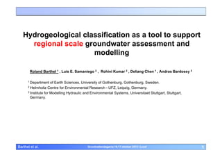
- 1. Hydrogeological classification as a tool to support regional scale groundwater assessment and modelling Roland Barthel 1 , Luis E. Samaniego 2 , Rohini Kumar 2 , Deliang Chen 1 , Andras Bardossy 3 1 Department of Earth Sciences, University of Gothenburg, Gothenburg, Sweden. 2 Helmholtz Centre for Environmental Research - UFZ, Leipzig, Germany. 3 Institute for Modelling Hydraulic and Environmental Systems, Universitaet Stuttgart, Stuttgart, Germany. Barthel et al. Grundvattendagarna 16-17 oktober 2013 i Lund 1
- 2. Starting point and motivation • Why the regional scale? – Integrated water resources management – European Water Framework Directive – Climate Change impact assessment Barthel et al. Grundvattendagarna 16-17 oktober 2013 i Lund 2
- 3. Starting point and motivation • Problems with regional scale hydrogeology: – Groundwater observations wells provide very local information at distinct points and are usually scarce and/or clustered – It is often difficult to decide how representative a groundwater observation well is – It is often difficult to decide if changes in groundwater observations are the result of natural or anthropogenic sources – Groundwater models are needed but require detailed representative data for parameterization and calibration everywhere Barthel et al. Grundvattendagarna 16-17 oktober 2013 i Lund 3
- 4. Summary of the challenges at the regional scale: High demand for regional scale groundwater assessment and modeling; but the available “raw” data does often not support this task • Is it possible to make predictions and assessments on the regional scale without using complex numerical models? • Can we improve numerical models using “unconventional” information? • How can we make better use of the existing information, of all the groundwater data we find in our archives? Barthel et al. Grundvattendagarna 16-17 oktober 2013 i Lund 4
- 5. Example data set: Upper Danube Catchment (Germany) Barthel et al. Grundvattendagarna 16-17 oktober 2013 i Lund 5
- 6. Data availability and spatial distribution Upper Danube Catchment, Southern Germany, 80,000 km2, ~2000 Groundwater observation wells >10years, at least weekly measurements Shallow alluvial aquifer Obs. well River Regional unconfined aquifer ? Regional, confined aquifer ? Barthel et al. Grundvattendagarna 16-17 oktober 2013 i Lund 6
- 7. Research Question • Is it possible to fill these “white spaces” using hydrogeological classification? Barthel et al. Grundvattendagarna 16-17 oktober 2013 i Lund 7
- 8. Groundwater “behavior” (time series of groundwater observations): Southern Germany GlowaID: 373 GlowaID: 324 GlowaID: 233 4 4 2 2 2 0 -2 -4 1979 GWL 6 GWL 6 4 GWL 6 0 -2 1983 1987 1991 1995 1999 2003 2007 -4 1979 0 -2 1983 GlowaID: 260 1987 1991 1995 1999 2003 -4 1979 2007 1995 1999 2003 2007 1999 2003 2007 1999 2003 2007 2 2 0 -4 1979 GWL 4 2 -2 0 -2 1983 1987 1991 1995 1999 2003 2007 -4 1979 0 -2 1983 GlowaID: 1285 1987 1991 1995 1999 2003 -4 1979 2007 1983 GlowaID: 1252 1987 1991 1995 GlowaID: 95 6 4 4 4 2 2 2 0 GWL 6 GWL 6 GWL 1991 6 4 GWL GWL 6 4 0 -2 -2 -4 1979 -4 1979 1983 1987 1991 1995 1999 2003 2007 0 -2 1983 GlowaID: 1693 1987 1991 1995 1999 2003 -4 1979 2007 1983 GlowaID: 1714 1987 1991 1995 GlowaID: 2454 6 4 4 2 2 2 0 -2 -4 1979 GWL 6 4 GWL 6 GWL 1987 GlowaID: 1440 6 0 -2 1983 1987 1991 1995 1999 2003 2007 -4 1979 0 -2 1983 GlowaID: 2563 1987 1991 1995 1999 2003 -4 1979 2007 1983 GlowaID: 1618 1987 1991 1995 1999 2003 2007 1999 2003 4 2 2 2 0 -2 -4 1979 GWL 6 4 GWL 6 4 All time series are 30 years long and normalized so that mean = 0 and standard deviation = 1 2007 GlowaID: 4417 6 GWL 1983 GlowaID: 564 0 -2 1983 1987 1991 Barthel et al. 1995 1999 2003 2007 -4 1979 0 -2 1983 1987 1991 1995 1999 2003 2007 -4 1979 1983 1987 1991 1995 Grundvattendagarna 16-17 oktober 2013 i Lund 8
- 9. Classification of time series GlowaID: 373 GlowaID: 324 GlowaID: 233 4 4 2 2 2 0 -2 -4 1979 GWL 6 GWL 6 4 GWL 6 0 -2 1983 1987 1991 1995 1999 2003 2007 -4 1979 0 -2 1983 GlowaID: 260 1987 1991 1995 1999 2003 -4 1979 2007 1995 1999 2003 2007 1999 2003 2007 1999 2003 2007 2 2 0 -4 1979 GWL 4 2 -2 0 -2 1983 1987 1991 1995 1999 2003 2007 -4 1979 0 -2 1983 GlowaID: 1285 1987 1991 1995 1999 2003 -4 1979 2007 1983 GlowaID: 1252 1987 1991 1995 GlowaID: 95 6 4 4 4 2 2 2 0 GWL 6 GWL 6 GWL 1991 6 4 GWL GWL 6 4 0 -2 -2 -4 1979 -4 1979 1983 1987 1991 1995 1999 2003 2007 0 -2 1983 GlowaID: 1693 1987 1991 1995 1999 2003 -4 1979 2007 1983 GlowaID: 1714 1987 1991 1995 GlowaID: 2454 6 4 4 2 2 2 0 GWL 6 4 GWL 6 GWL 1987 GlowaID: 1440 6 0 -2 -2 -4 1979 -4 1979 1983 1987 1991 1995 1999 2003 2007 0 -2 1983 GlowaID: 2563 1987 1991 1995 1999 2003 -4 1979 2007 1983 GlowaID: 1618 1987 1991 1995 1999 2003 2007 1999 2003 4 2 2 2 0 -2 -4 1979 GWL 6 4 GWL 6 4 7 main groups of different behavior based on spectral analysis 2007 GlowaID: 4417 6 GWL 1983 GlowaID: 564 0 -2 1983 1987 1991 Barthel et al. 1995 1999 2003 2007 -4 1979 0 -2 1983 1987 1991 1995 1999 2003 2007 -4 1979 1983 1987 1991 1995 Grundvattendagarna 16-17 oktober 2013 i Lund 9
- 10. Why are some time series more similar than others? 1. Often, but not always, similar time series are from observation wells which are close to each other 2. Very often, similar time series are from observation wells which are located in similar hydrogeological settings Similar hydrogeological settings similar behavior, similar time series Barthel et al. Grundvattendagarna 16-17 oktober 2013 i Lund 10
- 11. How can classification help? Classified Input Type: Recharge Classified Groundwater System Type Classifiable / Predictable Response Type: Groundwater Level 6 1 GWL 4 0 Jan Dec unconfined shallow 2 0 -2 -4 1979 1983 1987 1991 1995 1999 2003 2007 long term time series (30 years) 1 6 0 GWL 4 Jan Dec 2 0 -2 -4 1979 1983 1987 1991 1995 1999 2003 2007 unconfined deep Barthel et al. Grundvattendagarna 16-17 oktober 2013 i Lund 11
- 12. Groundwater “behavior” (time series of groundwater observations): Southern Germany GlowaID: 373 GlowaID: 324 GlowaID: 233 4 4 2 2 2 0 -2 -4 1979 GWL 6 GWL 6 4 GWL 6 0 -2 1983 1987 1991 1995 1999 2003 2007 -4 1979 0 -2 1983 GlowaID: 260 1987 1991 1995 1999 2003 -4 1979 2007 1995 1999 2003 2007 1999 2003 2007 1999 2003 2007 2 2 0 -4 1979 GWL 4 2 -2 0 -2 1983 1987 1991 1995 1999 2003 2007 -4 1979 0 -2 1983 GlowaID: 1285 1987 1991 1995 1999 2003 -4 1979 2007 1983 GlowaID: 1252 1987 1991 1995 GlowaID: 95 6 4 4 4 2 2 2 0 GWL 6 GWL 6 GWL 1991 6 4 GWL GWL 6 4 0 -2 -2 -4 1979 -4 1979 1983 1987 1991 1995 1999 2003 2007 0 -2 1983 GlowaID: 1693 1987 1991 1995 1999 2003 -4 1979 2007 1983 GlowaID: 1714 1987 1991 1995 GlowaID: 2454 6 4 4 2 2 2 0 -2 -4 1979 GWL 6 4 GWL 6 GWL 1987 GlowaID: 1440 6 0 -2 1983 1987 1991 1995 1999 2003 2007 -4 1979 0 -2 1983 GlowaID: 2563 1987 1991 1995 1999 2003 -4 1979 2007 1983 GlowaID: 1618 1987 1991 1995 1999 2003 2007 1999 2003 4 2 2 2 0 -2 -4 1979 GWL 6 4 GWL 6 4 All time series are 30 years long and normalized so that mean = 0 and standard deviation = 1 2007 GlowaID: 4417 6 GWL 1983 GlowaID: 564 0 -2 1983 1987 1991 Barthel et al. 1995 1999 2003 2007 -4 1979 0 -2 1983 1987 1991 1995 1999 2003 2007 -4 1979 1983 1987 1991 1995 Grundvattendagarna 16-17 oktober 2013 i Lund 12
- 13. Is all this particular to the data sets from Southern Germany? ? All time series are 30 years long and normalized so that mean = 0 and standard deviation = 1 Barthel et al. Grundvattendagarna 16-17 oktober 2013 i Lund 13
- 14. Summary 1. It becomes obvious that many groundwater observation wells show similar behavior, so that we can form groups of groundwater observation wells that behave the same way. 2. The similarity of the behavior can be related to a similarity of the hydrogeological setting Similar hydrogeology creates similar behavior knowing this allows us to predict the behavior of groundwater at a location with known hydrogeology but no observations Barthel et al. Grundvattendagarna 16-17 oktober 2013 i Lund 14
- 15. Workflow of our proposed research approach: 1. Comparative analysis and classification of groundwater time series group groundwater observations together based on their similarity 2. Classification of groundwater systems group hydrogeological settings based on the similarity of the hydrogeological situation 3. Determine the dependencies between the resulting groups 4. Predict the behavior of locations with no observations based on the found dependencies Barthel et al. Grundvattendagarna 16-17 oktober 2013 i Lund 15
- 16. Workflow of our proposed research approach: 1. Comparative analysis and classification of groundwater time series group groundwater observations together based on their similarity 2. Classification of groundwater systems group hydrogeological settings based on the similarity of the hydrogeological situation 3. Determine the dependencies between the resulting groups 4. Predict the behavior of locations with no observations based on the found dependencies Barthel et al. Grundvattendagarna 16-17 oktober 2013 i Lund 16
- 17. Making use of existing classification schemes Hydrogeological type settings Stejmar-Eklund, H., 2002 Barthel et al. Grundvattendagarna 16-17 oktober 2013 i Lund 17
- 18. Predictions of behavior based on classification hydrogeological settings Swedish National Atlas, Volume12, Berg och Jord, SNA, 2009 Barthel et al. Grundvattendagarna 16-17 oktober 2013 i Lund 18
- 19. Groundwater chemistry as additional information Correlation between NO3- and groundwater level GWS (m ü. NN) NO3 (mg/l) 46 44 42 40 38 36 34 32 30 28 26 NO3 (mg/l) NO3 (mg/l) 55 90 50 80 70 45 60 40 50 40 35 30 30 20 groundwaterlevel (m a.s.l) 572.0 571.5 571.0 570.5 570.0 569.5 569.0 568.5 568.0 567.5 567.0 GWS (m ü. NN) 582.0 219.0 581.5 218.0 581.0 217.0 580.5 216.0 215.0 580.0 214.0 579.5 NO3 (mg/l) 213.0 groundwaterlevel (m a.s.l) 10 579.0 25 NO3 (mg/l) groundwaterlevel (m a.s.l) 0 1990 1992 1994 1996 1998 1999 2001 2003 2005 2007 212.0 1990 1992 1994 1996 1998 e tim1999 2001 2003 2005 2007 Barthel et al. Grundvattendagarna 16-17 oktober 2013 i Lund 19
- 20. Groundwater chemistry: additional information to classify groundwater observations StationID: 5154 6 NO3, EC , O2 4 Nitrate Dissolved Oxygen Electric Conductivity 2 0 -2 -4 1990 1994 1998 2002 2006 Time [Date] StationID: 7196 StationID: 16839 4 NO3, EC , O2 6 4 NO3, EC , O2 6 2 0 2 0 -2 -2 -4 1990 -4 1990 1994 1998 Time [Date] 2002 2006 1994 1998 2002 2006 Time [Date] All positively correlated - only two out of three correlated etc. Barthel et al. Grundvattendagarna 16-17 oktober 2013 i Lund 20
- 21. Conclusions • Hydrogeological classification is possible, and can be based on existing concepts • What is new, is the combination of hydrogeological classification with the classification of the dynamic behavior (quantity and chemistry) • It requires both: – Advanced statistical tools – And “traditional” geological expertise • Classification of groundwater systems and systematic use of similarity of groundwater observations: – Might help to replace complex numerical models where they are not feasible – Can provide tools for the improvement and validation of numerical models • A wide range of applications in regional hydrogeology is possible, e.g. – Prediction of climate change impacts – Separation of natural and human impacts – Assessment of regional planning instruments (RBMs, WFD) Barthel et al. Grundvattendagarna 16-17 oktober 2013 i Lund 21
- 22. Hydrogeological classification as a tool to support regional scale groundwater assessment and modelling Roland Barthel 1 , Luis E. Samaniego 2 , Rohini Kumar 2 , Deliang Chen 1 , Andras Bardossy 3 1 Department of Earth Sciences, University of Gothenburg, Gothenburg, Sweden. 2 Helmholtz Centre for Environmental Research - UFZ, Leipzig, Germany. 3 Institute for Modelling Hydraulic and Environmental Systems, Universitaet Stuttgart, Stuttgart, Germany. Thank you for your attention! Barthel et al. Grundvattendagarna 16-17 oktober 2013 i Lund 22
- 23. How to deal with anthropogenic influences GlowaID: 81 GlowaID: 179 4 GlowaID: 183 4 2 2 2 0 GWL GWL GWL 0 -2 -2 -4 1979 -2 -4 1983 1987 1991 1995 1999 -4 1979 2003 1983 1987 GlowaID: 376 1991 1995 1999 2003 -6 1979 2007 4 -2 -4 2 -2 1988 1999 2003 2007 2 0 1992 GlowaID: 284 1996 2000 -2 1973 1977 1981 1985 1989 1993 1997 2001 2005 2004 GlowaID: 797 GlowaID: 1667 6 4 4 4 2 2 2 0 -2 -4 1979 GWL 6 GWL 6 GWL 1995 4 0 -6 1967 1971 1975 1979 1983 1987 1991 1995 1999 1991 6 GWL GWL 6 0 1987 GlowaID: 1717 8 2 0 -2 1983 1987 1991 1995 1999 2003 -4 1979 2007 Quasi-continuously 0 -2 1983 GlowaID: 1939 1987 1991 1995 1999 2003 -4 1979 2007 1983 GlowaID: 765 1987 1991 1995 1999 2003 2007 GlowaID: 530 6 4 4 2 2 Changes of variance 4 2 0 -2 -4 1979 GWL 6 GWL 6 GWL 1983 GlowaID: 677 4 GWL 0 0 -2 1983 1987 1991 Barthel et al. 1995 1999 2003 2007 -4 1979 0 Dis-continuously -2 1983 1987 1991 1995 1999 2003 2007 -4 1979 1983 1987 1991 1995 Grundvattendagarna 16-17 oktober 2013 i Lund 1999 2003 2007 23
- 24. Factors controlling the transient response and dependencies of parameters Z ? X Barthel et al. Grundvattendagarna 16-17 oktober 2013 i Lund 24