International Journal of Computational Engineering Research(IJCER)
Poster AGU 2013
1. Abstract
Optimal water management practices and strategies, in arid and semi-arid environments,
are often hindered by a lack of quantitative and qualitative understanding of
hydrological processes. Moreover, progressive overexploitation of groundwater
resources to meet agricultural, industrial, and domestic requirements is drawing concern
over the sustainability of such exhaustive abstraction levels, especially in environments
where groundwater is a major source of water. NASA’s GRACE (gravity recovery and
climate change experiment) mission, since March 2002, has advanced the understanding
of hydrological events, especially groundwater depletion, through integrated
measurements and modeling of terrestrial water mass. In this study, GLDAS variables
(rainfall rate, evapotranspiration rate, average soil moisture), were used in combination
with GRACE-generated gravitational anomalies maps, to quantify total water storage
change (TWSC) and groundwater storage change (GWSC) from January 2003 to
December 2010 (excluding June 2003), in the North-Western Sahara Aquifer System
(NWSAS) in northwestern Africa. Separately processed and computed GRACE products
by JPL (Jet Propulsion Laboratory, NASA), CSR (Center of Space Research, UT
Austin), GFZ (German Research Centre for Geoscience, Potsdam), and GRGS (Groupe
de recherches en geodesie spatiale), were used to determine which GRACE dataset(s)
best reflect total water storage and ground water changes in northwest Africa. First-
order estimates of annual TWSC for NWSAS (JPL: +5.3 BCM; CSR: -5.33 BCM; GFZ:
-10 BCM: GRGS: -10.5), were computed using zonal averaging over a span of eight
years. Preliminary findings of annual GWSC for NWSAS (JPL: +5.33 BCM; CSR: -6
BCM; GFZ: -9.47 BCM; GRGS: -9.8 BCM), were calculating using a water budget
approach, parameterized by GLDAS-derived soil moisture and evapotranspiration
values with GRACE-based TWSC. Initial results suggest CSR-processed datasets as
being most representative of TWSC/GWSC values in the NWSAS, given groundwater
abstraction estimates of 5 BCM/year, a conservative estimate considering it does not
include unaccounted abstractions or increased consumption in recent years. Conversely,
high abstraction rates and negligibly low recharge rates indicate the positive
TWSC/GWSC values generated from JPL-processed datasets are not accurately
representative of hydrologic changes in NWSAS. GFZ and GRGS groundwater
abstraction levels converge on an plausible estimate of -7.5 BCM/year, considering the
significant number of unregistered wells and groundwater abstraction in the NWSAS.
Results and DiscussionData
ConclusionsObjectives
The primary objective of this study is to quantify the impact of overpumping in the
North-Western Sahara Aquifer System (NWSAS) in Northwest and groundwater storage
change (GWSC) using GRACE satellite data. A secondary objective is the comparison
of 4 different GRACE products from a numerical and statistical perspective.
Study Area (Mamou, et al., 2006)
Location: Algeria, Libya, and Tunisia
Area: 1,064,833 sq. km
Biomes: Desert
Climate: hyper arid
Annual Rainfall: 20 to 100 mm
Economic Activity: Agriculture
Total water storage change (TWSC) maps were provided by level-3 GRACE products
from the following 4 GRACE processing centers:
Precipitation (P), Evapotranspiration (ET), and Soil Moisture (SM) were obtained
from 3-hourly, 1 degree GLDAS-1 (Noah 2.7.1) datasets.
Methodology
Remote Sensing
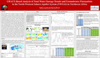
Changes in groundwater storage levels between 2003 and 2010 primarily display
conformity in fluctuation trends, yet vary in amplitude. The JPL dataset (blue) is
a clear example. Results suggest that differently processed GWSC estimates
could either overestimate or underestimate actual changes in groundwater, and
need to be calibrated.
CumulativeGWSC(cm)
Water Column (cm) Volumetric (BCM)
JPL CSR GFZ GRGS JPL CSR GFZ GRGS
2003 4.23 -2.35 -3.91 0.88 45.02 -25.02 -41.63 9.32
2004 2.91 -1.96 -3.67 -1.35 30.98 -20.89 -39.09 -14.42
2005 -3.75 -1.37 -2.51 0.15 -39.90 -14.63 -26.71 1.63
2006 -0.07 4.41 4.30 1.70 -0.72 46.98 45.81 18.10
2007 -4.26 0.20 0.62 0.08 -45.31 2.15 6.63 0.86
2008 -4.02 -3.13 -2.52 -2.62 -42.79 -33.31 -26.87 -27.95
2009 8.33 1.01 2.93 -0.63 88.74 10.71 31.22 -6.74
2010 0.62 -1.31 -2.36 -5.57 6.61 -13.93 -25.13 -59.26
Annual Average 0.50 -0.56 -0.89 -0.92 5.33 -5.99 -9.47 -9.81
Annual Groundwater Storage Changes Between 2003 and 2010
Goodness-of-Fit Analysis of TWSC Trend Components
Δ Groundwater Storage : A water balance approach was used to calculate GWSC in the
NWSAS. In hyper-arid environments characterized by the paucity of vegetation, surface
water bodies, and snow cover, the TWSC signal is dominated by: soil moisture and
groundwater storage. GWSC was calculated using the following equation:
Δ Groundwater Storage = Δ Total Water Storage – Δ Soil Moisture Storage
(modified from Rodell et. Al, 2007)
GRACE-Based Analysis of Total Water Storage Trends and Groundwater Fluctuations
in the North-Western Sahara Aquifer System (NWSAS) in Northwest Africa
Khalil A. Lezzaik and Adam M. Milewski
Department of Geology, University of Georgia, Athens, GA, USA
Scaled Annual Groundwater Storage Change Between 2003 and 2010
Groundwater abstraction values in the NWSAS,
provided by UNESCO and the “SAHARAAND
SAHEL OBSERVATORY”, were used to calculate an
annual groundwater withdrawal average.
Given an abstraction estimate of 2.5 BCM in 2000
(UNESCO, 2006), and a projected estimate of 8 BCM
in 2030 (OSS, 2006), an average withdrawal estimate
of 3.42 BCM was calculated for 2003-2010 (assuming a
linear increase in withdrawals).
Scale factors were applied to GWSC values to estimate
corrected GWSC values.
Year
Projection-Based
Annual Withdrawal
(BCM)
2000 2.50
2001 2.68
2002 2.87
2003 3.05
2004 3.23
2005 3.42
2006 3.60
2007 3.78
2008 3.96
2009 4.15
2010 4.33
Average 3.42
Preliminary results, from separately processed and computed GRACE products
(JPL, CSR, GFZ, and GRGS), were presented to estimate of annual GWSC in
the NWSAS (-0.92 cm/yr by the GRGS dataset, to +0.5 cm/yr by the JPL
product). Based on groundwater withdrawal estimates provided by international
agencies and scientific groups, the CSR GWSC estimate of -0.56 cm/yr is the
most definitive and corroborated assessment of actual groundwater change in
the NWSAS. Goodness-of-Fit tests on GWSC trends displayed a high degree
of fit between the CSR and GFZ trend. Lower measures of fit between the CSR
trend, and GFZ and GRGS trends, reflect significant differences in water height
amplitude which is indicative of possible overestimation/ underestimation of
GWSC by specific GRACE products. Annual GWSC were calculated for
countries within NWSAS’s boundaries (Algeria: -2.2 BCM; Libya: -2.32 BCM;
Tunisia: -0.368 BCM).
Future work
• Collecting in-situ groundwater withdrawal data and piezometric data in the
NWSAS to calibrate different GRACE products
• Evaluate the Spatial relationship of TWSC and GWSC in the NWSAS
Unscaled GRACE Image Scaled GRACE Image Processed GRACE Image
Annual TWSC Averages are shown from 2003 to 2010
GWSC timeseries from 2003 to 2010 for the 4 processing centers
Comparison of GRACE Products
Goodness-of-Fit tests conducted on
GWSC trends of the different GRACE
products displayed a high degree of fitness
(𝑅2
= 0.83, NSE= 0.72) between CSR
trends and GFZ trends.
GW Validation and Correction
Water Column (cm) Volumetric (BCM)
JPL CSR GFZ GRGS JPL CSR GFZ GRGS
Correction 57.58%
2003 2.44 -1.35 -2.25 0.51 25.92 -14.41 -23.97 5.37
2004 1.68 -1.13 -2.11 -0.78 17.84 -12.03 -22.51 -8.30
2005 -2.16 -0.79 -1.45 0.09 -22.97 -8.42 -15.38 0.94
2006 -0.04 2.54 2.48 0.98 -0.41 27.05 26.38 10.42
2007 -2.45 0.12 0.36 0.05 -26.09 1.24 3.82 0.50
2008 -2.31 -1.80 -1.45 -1.51 -24.64 -19.18 -15.47 -16.09
2009 4.80 0.58 1.69 -0.36 51.10 6.17 17.98 -3.88
2010 0.36 -0.75 -1.36 -3.21 3.81 -8.02 -14.47 -34.12
Annual Average 0.29 -0.32 -0.51 -0.53 3.07 -3.45 -5.45 -5.65
References:
Mamou, A. et al. (2006): North-Western Sahara Aquifer System (NWSAS), in: S. Foster / D. P. Loucks (eds.), Non-renewable Groundwater Resources: A
guidebook on socially sustainable management for water-policy makers, Paris: United Nations Educational, Scientific and Cultural Organization (IHP-VI
Series on Groundwater 10), 68–74
OSS (Observatoire du Sahara et du Sahel) (2004): Water Resources in the OSS Countries, Paris: United Nations
Educational, Scientific and Cultural Organization, 41