
Recommended
Recommended
More Related Content
What's hot
What's hot (20)
Similar to Barcelona_Urban Planning.docx
Similar to Barcelona_Urban Planning.docx (20)
Recently uploaded
Recently uploaded (20)
Barcelona_Urban Planning.docx
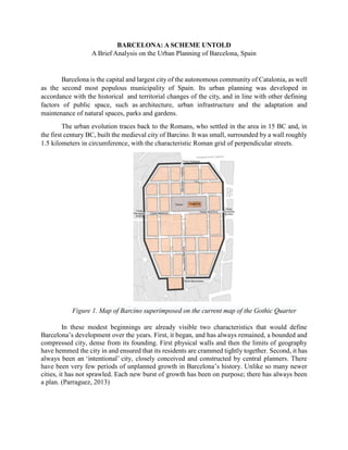
- 1. BARCELONA: A SCHEME UNTOLD A Brief Analysis on the Urban Planning of Barcelona, Spain Barcelona is the capital and largest city of the autonomous community of Catalonia, as well as the second most populous municipality of Spain. Its urban planning was developed in accordance with the historical and territorial changes of the city, and in line with other defining factors of public space, such as architecture, urban infrastructure and the adaptation and maintenance of natural spaces, parks and gardens. The urban evolution traces back to the Romans, who settled in the area in 15 BC and, in the first century BC, built the medieval city of Barcino. It was small, surrounded by a wall roughly 1.5 kilometers in circumference, with the characteristic Roman grid of perpendicular streets. Figure 1. Map of Barcino superimposed on the current map of the Gothic Quarter In these modest beginnings are already visible two characteristics that would define Barcelona’s development over the years. First, it began, and has always remained, a bounded and compressed city, dense from its founding. First physical walls and then the limits of geography have hemmed the city in and ensured that its residents are crammed tightly together. Second, it has always been an ‘intentional’ city, closely conceived and constructed by central planners. There have been very few periods of unplanned growth in Barcelona’s history. Unlike so many newer cities, it has not sprawled. Each new burst of growth has been on purpose; there has always been a plan. (Parraguez, 2013)
- 2. Over the centuries, the city has been transformed again and again at the hands of visionaries, mostly notably architect Ildefons Cerdà, still considered one of history’s great urban planners. Exploring that history can help illuminate the promise and perils that face Barcelona’s modern-day visionary, urban planner Salvador Rueda, who is now attempting to transform the city again, to prepare it for the coming rigors of climate change by making it less noisy, less polluted, and more walkable and sociable — all of which involves pushing back the tide of cars. Barcelona has been at the forefront of innovative urban planning and design over the years, incorporating various urban planning theories and strategies to shape its development. One of the prominent theories and approaches used in Barcelona's urban planning is the concept of "superblocks" or "superilles" in Catalan. These are a key feature of Barcelona's urban planning strategy. This concept was introduced as part of the "Plan Cerdà" in the mid-19th century, which aimed to create a more organized and efficient urban layout (EBRD, n.d.). In recent years, Barcelona has reimagined and implemented the superblock concept with a modern twist. Figure 2. Barcelona’s Eixample district showcasing the superblock neighborhoods A superblock is essentially a large city block that combines several smaller blocks within it. The idea is to reclaim space from cars and allocate it for pedestrians, green areas, and community activities. The following is a brief overview of how superblocks work in Barcelona: Restricts Traffic: Superblocks are designed to limit vehicular traffic within their boundaries. The perimeter of the superblock is often equipped with barriers to discourage through-traffic, creating a more pedestrian-friendly environment. Prioritizes Pedestrians: With reduced car traffic, superblocks prioritize pedestrians and cyclists. This encourages walking, cycling, and the use of public transportation, contributing to a more sustainable and healthier urban lifestyle. Enhances Public Spaces: Superblocks typically feature more public spaces, such as parks, plazas, and courtyards. These areas are designed for recreational activities, social
- 3. gatherings, and community events, fostering a sense of belonging and community engagement. Promotes Mixed Land Use: Barcelona's superblocks aim to mix land uses within each block. This can include a blend of residential, commercial, and cultural spaces, creating vibrant, mixed-use neighborhoods that reduce the need for long commutes. Greens the City: Superblocks often incorporate greenery, such as trees and plants, to improve air quality and aesthetics. This not only beautifies the urban environment but also contributes to a more sustainable and resilient city. Its innovative approach to urban planning through superblocks has garnered international attention for its potential to improve quality of life, reduce pollution, and address urban challenges. While not without its challenges and criticisms, this urban planning theory reflects Barcelona's commitment to creating more livable and sustainable urban spaces for its residents. Barcelona’s current administrative boundaries define the extent of the city, and these boundaries are made up of several districts, neighborhoods, and suburbs. As of 2018, below are the main districts and neighborhoods that constitute the city of Barcelona (Ajuntament de Barcelona, 2021): Figure 3. Map of ten districts that constitutes Barcelona 1. Ciutat Vella: This is the historic old town of Barcelona and includes neighborhoods like the Gothic Quarter (Barri Gòtic), El Raval, El Born, and Barceloneta. 2. Eixample: Known for its grid layout and Modernist architecture, this district is divided into Eixample Esquerra (left) and Eixample Dreta (right). 3. Sants-Montjuïc: This district includes the Montjuïc hill, the neighborhoods of Sants, Poble Sec, and the area around the Sants train station. 4. Les Corts: Home to the Camp Nou stadium (FC Barcelona's home), this district also includes the neighborhoods of Les Corts and La Maternitat i Sant Ramon.
- 4. 5. Sarrià-Sant Gervasi: Located in the northern part of the city, this district includes affluent neighborhoods such as Sarrià, Sant Gervasi, and parts of Gràcia. 6. Gràcia: A trendy and artistic district known for its vibrant nightlife and cultural scene. 7. Horta-Guinardó: Located in the northeastern part of Barcelona, this district includes Horta and Guinardó neighborhoods. 8. Nou Barris: Situated in the northern part of the city, this district includes neighborhoods like Vilapicina i la Torre Llobeta and Roquetes. 9. Sant Andreu: Located in the northern part of Barcelona, this district includes neighborhoods such as Sant Andreu de Palomar and La Sagrera. 10. Sant Martí: Situated in the eastern part of the city, this district includes neighborhoods like Poblenou, El Clot, and Diagonal Mar. As already noted, the original Cerdà plan of 1855 for the extension of Barcelona is famous for its grid array of large blocks and wide streets to promote circulation. Each block was originally intended to have an area of open space in the center to provide for the needs of residents. Already by the 1920s, however, the center of the blocks had been filled with buildings. Barcelona currently suffers from a chronic lack of open space, excess noise, and air pollution that exceeds European Union law. In recent years, it has been grappling with the consequences of its spiraling success, familiar to many growing cities: It is overrun by tourists, real estate prices are rising due to foreign speculation, gentrification is pushing out longtime residents, and there are too many cars, bringing noise, air pollution, and congestion. In a city as compressed and crowded as Barcelona, these problems are no longer tolerable. The task for urban planners now is to harness the city’s success in service of yet another transformation, into a model for the 21st century, designed around people and public spaces rather than motor vehicles. References: Ajuntament de Barcelona. (2021). Estadística i Difusió de Dades. https://ajuntament.barcelona. cat/estadistica/catala/Territori/sup/a2018/S02.htm Parraguez, Nicolás (2013), Modelo Barcelona de espacio público y diseño urbano. El mobiliario urbano en la cualificación del espacio público (in Spanish), Barcelona: Universitat de Barcelona, ISBN 978-84-7739-179-1 EBRD. (n.d.). Urban planning with superblocks: Barcelona, Spain. https://www.ebrdgreencities.com/policy-tool/urban-planning-with- superblocks- barcelona-spain-2/