IkeGPS Katrina Case Study
•
1 like•298 views

The US Army Corps of Engineers used ikeGPS mobile mapping technology to assist with damage assessment efforts following Hurricane Katrina in 2005. ikeGPS allowed USACE operators to safely collect data on hazardous sites from a distance. The collected data was integrated into GIS databases to map damaged areas and plan relief missions. ikeGPS proved to be an effective solution for fast and efficient data collection at scale, supporting optimal decision making during disaster recovery.

Recommended
More Related Content
What's hot
What's hot (20)
Viewers also liked
Similar to IkeGPS Katrina Case Study
Similar to IkeGPS Katrina Case Study (20)
Recently uploaded
Recently uploaded (20)
IkeGPS Katrina Case Study
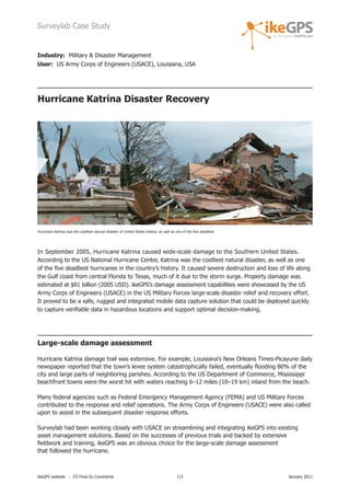
- 1. Surveylab Case Study Industry: Military & Disaster Management User: US Army Corps of Engineers (USACE), Louisiana, USA Hurricane Katrina Disaster Recovery Hurricane Katrina was the costliest natural disaster of United States history, as well as one of the five deadliest. In September 2005, Hurricane Katrina caused wide-scale damage to the Southern United States. According to the US National Hurricane Center, Katrina was the costliest natural disaster, as well as one of the five deadliest hurricanes in the country’s history. It caused severe destruction and loss of life along the Gulf coast from central Florida to Texas, much of it due to the storm surge. Property damage was estimated at $81 billion (2005 USD). ikeGPS’s damage assessment capabilities were showcased by the US Army Corps of Engineers (USACE) in the US Military Forces large-scale disaster relief and recovery effort. It proved to be a safe, rugged and integrated mobile data capture solution that could be deployed quickly to capture verifiable data in hazardous locations and support optimal decision-making. Large-scale damage assessment Hurricane Katrina damage trail was extensive. For example, Louisiana’s New Orleans Times-Picayune daily newspaper reported that the town’s levee system catastrophically failed, eventually flooding 80% of the city and large parts of neighboring parishes. According to the US Department of Commerce, Mississippi beachfront towns were the worst hit with waters reaching 6–12 miles (10–19 km) inland from the beach. Many federal agencies such as Federal Emergency Management Agency (FEMA) and US Military Forces contributed to the response and relief operations. The Army Corps of Engineers (USACE) were also called upon to assist in the subsequent disaster response efforts. Surveylab had been working closely with USACE on streamlining and integrating ikeGPS into existing asset management solutions. Based on the successes of previous trials and backed by extensive fieldwork and training, ikeGPS was an obvious choice for the large-scale damage assessment that followed the hurricane. ikeGPS website - CS Final Ex Comments 1|3 January 2011
- 2. Surveylab Case Study In the immediate aftermath, it was vital to know the precise location of particular landmarks deep within the disaster zones and their geospatial relationship to each other. The enormity of the damage meant that many features of importance had been altered or obstructed. Pre-hurricane information and digital data wasn’t complete and reliable enough to guarantee safe access for recovery workers in the worst hit disaster areas. Comprehensive, detailed and fast field data collection was therefore required to map damaged areas, obstacles and hazard zones before effective relief missions were planned and teams deployed. USACE operators kept safe while recording data on hazardous sites USACE was faced with numerous site access problems during the relief efforts. A large number of potential biohazards such as oil spills needed to be located as specific planning or responses were required for these areas. ikeGPS was deployed to survey these sites, collect photos and crucial location data for the recovery planning process. ikeGPS’s ability to capture detailed geographic information and field notes from a distance meant that dangerous sites or sites with unsafe access Hurricane Katrina’s aftermath. could be identified and recorded from afar by USACE while keeping ikeGPS operators safe at all times. The ikeGPS laser range finder allowed operators to efficiently capture information on multiple sites located up to 1000 meters away from a single, safe and secure location. Following damage assessment of critical infrastructure during the emergency, additional site assessments and further collection of infrastructure data were carried out in downtown New Orleans, along with surveys of damaged canals and levees on the Mississippi River. Quick, fast and efficient ikeGPS deployment ensured effective decision-making Once USACE ikeGPS operators completed fieldwork, data collected via a user-specific application was transferred directly to the US Engineering Infrastructure Intelligence Reachback Centre (EI2RC) centralized ESRI ArcGIS geo-database. Field data and photographs were integrated and verified against existing geo information. Data was quickly processed to create up-to-date maps of the areas surveyed. The maps were posted online and used to plan and coordinate rescue efforts, allowing efficient decision-making. The use of ikeGPS mobile data capture solution in such a large scale recovery effort highlights the quality and reliability of ikeGPS as a field information collection and mapping tool in emergency situations. Its simplicity allows for fast and efficient large-scale unit deployment, whilst its flexibility allows operators to quickly adapt the device for the task at hand. ikeGPS website - CS Katrina Traps Final Ex Comments 2|3 January 2011
- 3. Surveylab Case Study AT A GLANCE Key reasons USACE selected ikeGPS • Allowed quick assessment and verifiable data to be collected on hazardous sites, or sites with restricted access • Site assessments performed before planning and coordinating disaster response missions and sending rescue teams • ikeGPS had already performed well in previous asset management trials • ikeGPS to corporate GIS database workflow already successfully tested in pre-Katrina missions and backed by extensive fieldwork and training Key benefits for USACE • Laser-range finder allowed operators to efficiently capture information on multiple sites located up to 1000 meters away, from a single safe and secure location • Fast data collection system and easily deployed in the field • Ease-of-use and integrated features into a single handheld rugged device • Could be deployed quickly and integrated seamlessly with current ArcGIS systems for optimal decision-making Technology used • ikeGPS field data collection solution from Surveylab • ESRI ArcGIS • ArcPad Mobile GIS software For more information please contact: Richard Taylor Vice President - ikeGPS Americas richard.taylor@ikegps.com office: (281) 681 0356 fax: (281) 681 9252 www.ikeGPS.com ikeGPS website - CS Katrina Final Ex Comments 3|3 January 2011