SlideShare a Scribd company logo
1 of 7
Download to read offline
Install DSM software
• QGIS
• SAGA
• R
• Rstudio
• ILWIS
Create DSM workspace
 C:DSM - where we will work
 C:DSMInput - where to keep input data
 C:DSMOutput - where to keep output data
Familiarity with MS Office
Example: Soil profile data from ISRIC
Explore data and develop database
• Import maps in QGIS and explore
• Open MS Office data and explore
• Scan hard copy maps and explore
• Exploration
– Legend
– Contents (codes, classes, missing, range, etc.)
– Georeferencing (Projection, coordinates, tie-points)
– Documentation (report, methods, etc)
• Classify data quality
Building geo-database
• Geo-reference the images
• Digitize boundaries where possible
• Enter/convert the point-data into CSV
database
• Re-project the maps to common datum
– MODIS (in Sinusoidal-Sphere projection) : convert
+proj=sinu +lon_0=30 +x_0=0 +y_0=0 +a=6370997
+b=6371000 +units=m +no_defs
• Save all the project/database in one folder
Example geo-database
• Use tie-points to georeference the jpeg image
• Digitize and build geo-database where possible
(and clean using topology clean tool)
• Import other layers (environmental factors)
• Import MS Excel files into geo-database (use CSV)
and convert to shapefiles
• Document all the data in the database
Assignment: Building geo-database for
DSM application-STEP 1
• Use your own data
• Explore the data
• Follow the steps for building the geo-database
• Build the DSM geo-database
• Save the database (C:DSMInput)
• Remember to hand in your work by Next
Morning before start of the session

More Related Content

What's hot

Using R to Visualize Spatial Data: R as GIS - Guy Lansley
Using R to Visualize Spatial Data: R as GIS - Guy LansleyUsing R to Visualize Spatial Data: R as GIS - Guy Lansley
Using R to Visualize Spatial Data: R as GIS - Guy LansleyGuy Lansley
 
Spatial Data Science with R
Spatial Data Science with RSpatial Data Science with R
Spatial Data Science with Ramsantac
 
Lecture 1b introduction to arc gis
Lecture 1b  introduction to arc gisLecture 1b  introduction to arc gis
Lecture 1b introduction to arc gisAbir Mohammad
 
Defination of gis and components of arc gis
Defination of gis and components of arc gisDefination of gis and components of arc gis
Defination of gis and components of arc gisSreedhar Siddhu
 
The National Soil Information System of Sudan
The National Soil Information System of SudanThe National Soil Information System of Sudan
The National Soil Information System of SudanExternalEvents
 
R Spatial Analysis using SP
R Spatial Analysis using SPR Spatial Analysis using SP
R Spatial Analysis using SPtjagger
 
Exploring spatial data in GIS Environment
Exploring spatial data in GIS Environment Exploring spatial data in GIS Environment
Exploring spatial data in GIS Environment NAXA-Developers
 
e-SOTER Regional pilot platform as EU contribution to a Global Soil observing...
e-SOTER Regional pilot platform as EU contribution to a Global Soil observing...e-SOTER Regional pilot platform as EU contribution to a Global Soil observing...
e-SOTER Regional pilot platform as EU contribution to a Global Soil observing...FAO
 
Dr Richard Fry - Using R as a GIS
Dr Richard Fry - Using R as a GISDr Richard Fry - Using R as a GIS
Dr Richard Fry - Using R as a GISShaun Lewis
 
GIS and QGIS training notes
GIS and QGIS training notesGIS and QGIS training notes
GIS and QGIS training notesArnold Kilaini
 
GIS and Mapping Software Introduction
GIS and Mapping Software IntroductionGIS and Mapping Software Introduction
GIS and Mapping Software IntroductionMEASURE Evaluation
 

What's hot (20)

Using R to Visualize Spatial Data: R as GIS - Guy Lansley
Using R to Visualize Spatial Data: R as GIS - Guy LansleyUsing R to Visualize Spatial Data: R as GIS - Guy Lansley
Using R to Visualize Spatial Data: R as GIS - Guy Lansley
 
Spatial Data Science with R
Spatial Data Science with RSpatial Data Science with R
Spatial Data Science with R
 
Portfolio_Gis_others
Portfolio_Gis_othersPortfolio_Gis_others
Portfolio_Gis_others
 
Adding data into GIS
Adding  data into GISAdding  data into GIS
Adding data into GIS
 
Józsa e.
Józsa e.Józsa e.
Józsa e.
 
Spatial is Not Special ?
Spatial is Not Special ?Spatial is Not Special ?
Spatial is Not Special ?
 
Lecture 1b introduction to arc gis
Lecture 1b  introduction to arc gisLecture 1b  introduction to arc gis
Lecture 1b introduction to arc gis
 
Defination of gis and components of arc gis
Defination of gis and components of arc gisDefination of gis and components of arc gis
Defination of gis and components of arc gis
 
The National Soil Information System of Sudan
The National Soil Information System of SudanThe National Soil Information System of Sudan
The National Soil Information System of Sudan
 
R Spatial Analysis using SP
R Spatial Analysis using SPR Spatial Analysis using SP
R Spatial Analysis using SP
 
Georeferencing
GeoreferencingGeoreferencing
Georeferencing
 
Exploring spatial data in GIS Environment
Exploring spatial data in GIS Environment Exploring spatial data in GIS Environment
Exploring spatial data in GIS Environment
 
e-SOTER Regional pilot platform as EU contribution to a Global Soil observing...
e-SOTER Regional pilot platform as EU contribution to a Global Soil observing...e-SOTER Regional pilot platform as EU contribution to a Global Soil observing...
e-SOTER Regional pilot platform as EU contribution to a Global Soil observing...
 
Dr Richard Fry - Using R as a GIS
Dr Richard Fry - Using R as a GISDr Richard Fry - Using R as a GIS
Dr Richard Fry - Using R as a GIS
 
Projections
ProjectionsProjections
Projections
 
The Analogues R-Package - Ramirez-Villegas
The Analogues R-Package - Ramirez-VillegasThe Analogues R-Package - Ramirez-Villegas
The Analogues R-Package - Ramirez-Villegas
 
Os Percy
Os PercyOs Percy
Os Percy
 
GIS fundamentals - raster
GIS fundamentals - rasterGIS fundamentals - raster
GIS fundamentals - raster
 
GIS and QGIS training notes
GIS and QGIS training notesGIS and QGIS training notes
GIS and QGIS training notes
 
GIS and Mapping Software Introduction
GIS and Mapping Software IntroductionGIS and Mapping Software Introduction
GIS and Mapping Software Introduction
 

Similar to Install Digital Soil Mapping Software

Building Location Aware Apps - Get Started with PostGIS, PART II
Building Location Aware Apps - Get Started with PostGIS, PART IIBuilding Location Aware Apps - Get Started with PostGIS, PART II
Building Location Aware Apps - Get Started with PostGIS, PART IIlasmasi
 
GIS for Recorders
GIS for RecordersGIS for Recorders
GIS for RecordersSK53
 
GIS_Whirlwind_Tour.ppt
GIS_Whirlwind_Tour.pptGIS_Whirlwind_Tour.ppt
GIS_Whirlwind_Tour.pptFatima891926
 
GIS_Whirlwind_Tour.ppt
GIS_Whirlwind_Tour.pptGIS_Whirlwind_Tour.ppt
GIS_Whirlwind_Tour.pptsafayetmim1
 
GIS_Whirlwind_Tour.ppt
GIS_Whirlwind_Tour.pptGIS_Whirlwind_Tour.ppt
GIS_Whirlwind_Tour.pptvikramvsu
 
Gis and digital_map_fundamentals
Gis and digital_map_fundamentalsGis and digital_map_fundamentals
Gis and digital_map_fundamentalsSumant Diwakar
 
Databases Basics and Spacial Matrix - Discussig Geographic Potentials of Data...
Databases Basics and Spacial Matrix - Discussig Geographic Potentials of Data...Databases Basics and Spacial Matrix - Discussig Geographic Potentials of Data...
Databases Basics and Spacial Matrix - Discussig Geographic Potentials of Data...Jerin John
 
Modelling complex geometry structures using SAP2000 API
Modelling complex geometry structures using SAP2000 APIModelling complex geometry structures using SAP2000 API
Modelling complex geometry structures using SAP2000 APIValerio Stuart
 
Efficient Query Processing in Geographic Web Search Engines
Efficient Query Processing in Geographic Web Search EnginesEfficient Query Processing in Geographic Web Search Engines
Efficient Query Processing in Geographic Web Search EnginesYen-Yu Chen
 
ITResumeKlonWaldrip
ITResumeKlonWaldripITResumeKlonWaldrip
ITResumeKlonWaldripKlon Waldrip
 
Vancouver AWS Meetup Slides 11-20-2018 Apache Spark with Amazon EMR
Vancouver AWS Meetup Slides 11-20-2018 Apache Spark with Amazon EMRVancouver AWS Meetup Slides 11-20-2018 Apache Spark with Amazon EMR
Vancouver AWS Meetup Slides 11-20-2018 Apache Spark with Amazon EMRAllice Shandler
 
Large Scale Geo Processing on Hadoop
Large Scale Geo Processing on HadoopLarge Scale Geo Processing on Hadoop
Large Scale Geo Processing on HadoopChristoph Körner
 

Similar to Install Digital Soil Mapping Software (20)

ArcGIS and Multi-D: Tools & Roadmap
ArcGIS and Multi-D: Tools & RoadmapArcGIS and Multi-D: Tools & Roadmap
ArcGIS and Multi-D: Tools & Roadmap
 
Day 6 - PostGIS
Day 6 - PostGISDay 6 - PostGIS
Day 6 - PostGIS
 
Building Location Aware Apps - Get Started with PostGIS, PART II
Building Location Aware Apps - Get Started with PostGIS, PART IIBuilding Location Aware Apps - Get Started with PostGIS, PART II
Building Location Aware Apps - Get Started with PostGIS, PART II
 
GIS for Recorders
GIS for RecordersGIS for Recorders
GIS for Recorders
 
GIS_Whirlwind_Tour.ppt
GIS_Whirlwind_Tour.pptGIS_Whirlwind_Tour.ppt
GIS_Whirlwind_Tour.ppt
 
GIS_Whirlwind_Tour.ppt
GIS_Whirlwind_Tour.pptGIS_Whirlwind_Tour.ppt
GIS_Whirlwind_Tour.ppt
 
GIS_Whirlwind_Tour.ppt
GIS_Whirlwind_Tour.pptGIS_Whirlwind_Tour.ppt
GIS_Whirlwind_Tour.ppt
 
GIS_Whirlwind_Tour.ppt
GIS_Whirlwind_Tour.pptGIS_Whirlwind_Tour.ppt
GIS_Whirlwind_Tour.ppt
 
Gis and digital_map_fundamentals
Gis and digital_map_fundamentalsGis and digital_map_fundamentals
Gis and digital_map_fundamentals
 
Databases Basics and Spacial Matrix - Discussig Geographic Potentials of Data...
Databases Basics and Spacial Matrix - Discussig Geographic Potentials of Data...Databases Basics and Spacial Matrix - Discussig Geographic Potentials of Data...
Databases Basics and Spacial Matrix - Discussig Geographic Potentials of Data...
 
Modelling complex geometry structures using SAP2000 API
Modelling complex geometry structures using SAP2000 APIModelling complex geometry structures using SAP2000 API
Modelling complex geometry structures using SAP2000 API
 
Efficient Query Processing in Geographic Web Search Engines
Efficient Query Processing in Geographic Web Search EnginesEfficient Query Processing in Geographic Web Search Engines
Efficient Query Processing in Geographic Web Search Engines
 
Q GIS Training Presentation
Q GIS Training PresentationQ GIS Training Presentation
Q GIS Training Presentation
 
Scala and spark
Scala and sparkScala and spark
Scala and spark
 
Essentials of R
Essentials of REssentials of R
Essentials of R
 
ITResumeKlonWaldrip
ITResumeKlonWaldripITResumeKlonWaldrip
ITResumeKlonWaldrip
 
Advancing Scientific Data Support in ArcGIS
Advancing Scientific Data Support in ArcGISAdvancing Scientific Data Support in ArcGIS
Advancing Scientific Data Support in ArcGIS
 
Geocart workshop
Geocart workshopGeocart workshop
Geocart workshop
 
Vancouver AWS Meetup Slides 11-20-2018 Apache Spark with Amazon EMR
Vancouver AWS Meetup Slides 11-20-2018 Apache Spark with Amazon EMRVancouver AWS Meetup Slides 11-20-2018 Apache Spark with Amazon EMR
Vancouver AWS Meetup Slides 11-20-2018 Apache Spark with Amazon EMR
 
Large Scale Geo Processing on Hadoop
Large Scale Geo Processing on HadoopLarge Scale Geo Processing on Hadoop
Large Scale Geo Processing on Hadoop
 

More from FAO

Nigeria
NigeriaNigeria
NigeriaFAO
 
Niger
NigerNiger
NigerFAO
 
Namibia
NamibiaNamibia
NamibiaFAO
 
Mozambique
MozambiqueMozambique
MozambiqueFAO
 
Zimbabwe takesure
Zimbabwe takesureZimbabwe takesure
Zimbabwe takesureFAO
 
Zimbabwe
ZimbabweZimbabwe
ZimbabweFAO
 
Zambia
ZambiaZambia
ZambiaFAO
 
Togo
TogoTogo
TogoFAO
 
Tanzania
TanzaniaTanzania
TanzaniaFAO
 
Spal presentation
Spal presentationSpal presentation
Spal presentationFAO
 
Rwanda
RwandaRwanda
RwandaFAO
 
Nigeria uponi
Nigeria uponiNigeria uponi
Nigeria uponiFAO
 
The multi-faced role of soil in the NENA regions (part 2)
The multi-faced role of soil in the NENA regions (part 2)The multi-faced role of soil in the NENA regions (part 2)
The multi-faced role of soil in the NENA regions (part 2)FAO
 
The multi-faced role of soil in the NENA regions (part 1)
The multi-faced role of soil in the NENA regions (part 1)The multi-faced role of soil in the NENA regions (part 1)
The multi-faced role of soil in the NENA regions (part 1)FAO
 
Agenda of the launch of the soil policy brief at the Land&Water Days
Agenda of the launch of the soil policy brief at the Land&Water DaysAgenda of the launch of the soil policy brief at the Land&Water Days
Agenda of the launch of the soil policy brief at the Land&Water DaysFAO
 
Agenda of the 5th NENA Soil Partnership meeting
Agenda of the 5th NENA Soil Partnership meetingAgenda of the 5th NENA Soil Partnership meeting
Agenda of the 5th NENA Soil Partnership meetingFAO
 
The Voluntary Guidelines for Sustainable Soil Management
The Voluntary Guidelines for Sustainable Soil ManagementThe Voluntary Guidelines for Sustainable Soil Management
The Voluntary Guidelines for Sustainable Soil ManagementFAO
 
GLOSOLAN - Mission, status and way forward
GLOSOLAN - Mission, status and way forwardGLOSOLAN - Mission, status and way forward
GLOSOLAN - Mission, status and way forwardFAO
 
Towards a Global Soil Information System (GLOSIS)
Towards a Global Soil Information System (GLOSIS)Towards a Global Soil Information System (GLOSIS)
Towards a Global Soil Information System (GLOSIS)FAO
 
GSP developments of regional interest in 2019
GSP developments of regional interest in 2019GSP developments of regional interest in 2019
GSP developments of regional interest in 2019FAO
 

More from FAO (20)

Nigeria
NigeriaNigeria
Nigeria
 
Niger
NigerNiger
Niger
 
Namibia
NamibiaNamibia
Namibia
 
Mozambique
MozambiqueMozambique
Mozambique
 
Zimbabwe takesure
Zimbabwe takesureZimbabwe takesure
Zimbabwe takesure
 
Zimbabwe
ZimbabweZimbabwe
Zimbabwe
 
Zambia
ZambiaZambia
Zambia
 
Togo
TogoTogo
Togo
 
Tanzania
TanzaniaTanzania
Tanzania
 
Spal presentation
Spal presentationSpal presentation
Spal presentation
 
Rwanda
RwandaRwanda
Rwanda
 
Nigeria uponi
Nigeria uponiNigeria uponi
Nigeria uponi
 
The multi-faced role of soil in the NENA regions (part 2)
The multi-faced role of soil in the NENA regions (part 2)The multi-faced role of soil in the NENA regions (part 2)
The multi-faced role of soil in the NENA regions (part 2)
 
The multi-faced role of soil in the NENA regions (part 1)
The multi-faced role of soil in the NENA regions (part 1)The multi-faced role of soil in the NENA regions (part 1)
The multi-faced role of soil in the NENA regions (part 1)
 
Agenda of the launch of the soil policy brief at the Land&Water Days
Agenda of the launch of the soil policy brief at the Land&Water DaysAgenda of the launch of the soil policy brief at the Land&Water Days
Agenda of the launch of the soil policy brief at the Land&Water Days
 
Agenda of the 5th NENA Soil Partnership meeting
Agenda of the 5th NENA Soil Partnership meetingAgenda of the 5th NENA Soil Partnership meeting
Agenda of the 5th NENA Soil Partnership meeting
 
The Voluntary Guidelines for Sustainable Soil Management
The Voluntary Guidelines for Sustainable Soil ManagementThe Voluntary Guidelines for Sustainable Soil Management
The Voluntary Guidelines for Sustainable Soil Management
 
GLOSOLAN - Mission, status and way forward
GLOSOLAN - Mission, status and way forwardGLOSOLAN - Mission, status and way forward
GLOSOLAN - Mission, status and way forward
 
Towards a Global Soil Information System (GLOSIS)
Towards a Global Soil Information System (GLOSIS)Towards a Global Soil Information System (GLOSIS)
Towards a Global Soil Information System (GLOSIS)
 
GSP developments of regional interest in 2019
GSP developments of regional interest in 2019GSP developments of regional interest in 2019
GSP developments of regional interest in 2019
 

Recently uploaded

call girls in Kamla Market (DELHI) 🔝 >༒9953330565🔝 genuine Escort Service 🔝✔️✔️
call girls in Kamla Market (DELHI) 🔝 >༒9953330565🔝 genuine Escort Service 🔝✔️✔️call girls in Kamla Market (DELHI) 🔝 >༒9953330565🔝 genuine Escort Service 🔝✔️✔️
call girls in Kamla Market (DELHI) 🔝 >༒9953330565🔝 genuine Escort Service 🔝✔️✔️9953056974 Low Rate Call Girls In Saket, Delhi NCR
 
Paris 2024 Olympic Geographies - an activity
Paris 2024 Olympic Geographies - an activityParis 2024 Olympic Geographies - an activity
Paris 2024 Olympic Geographies - an activityGeoBlogs
 
Introduction to ArtificiaI Intelligence in Higher Education
Introduction to ArtificiaI Intelligence in Higher EducationIntroduction to ArtificiaI Intelligence in Higher Education
Introduction to ArtificiaI Intelligence in Higher Educationpboyjonauth
 
Computed Fields and api Depends in the Odoo 17
Computed Fields and api Depends in the Odoo 17Computed Fields and api Depends in the Odoo 17
Computed Fields and api Depends in the Odoo 17Celine George
 
भारत-रोम व्यापार.pptx, Indo-Roman Trade,
भारत-रोम व्यापार.pptx, Indo-Roman Trade,भारत-रोम व्यापार.pptx, Indo-Roman Trade,
भारत-रोम व्यापार.pptx, Indo-Roman Trade,Virag Sontakke
 
BASLIQ CURRENT LOOKBOOK LOOKBOOK(1) (1).pdf
BASLIQ CURRENT LOOKBOOK  LOOKBOOK(1) (1).pdfBASLIQ CURRENT LOOKBOOK  LOOKBOOK(1) (1).pdf
BASLIQ CURRENT LOOKBOOK LOOKBOOK(1) (1).pdfSoniaTolstoy
 
EPANDING THE CONTENT OF AN OUTLINE using notes.pptx
EPANDING THE CONTENT OF AN OUTLINE using notes.pptxEPANDING THE CONTENT OF AN OUTLINE using notes.pptx
EPANDING THE CONTENT OF AN OUTLINE using notes.pptxRaymartEstabillo3
 
Alper Gobel In Media Res Media Component
Alper Gobel In Media Res Media ComponentAlper Gobel In Media Res Media Component
Alper Gobel In Media Res Media ComponentInMediaRes1
 
Mastering the Unannounced Regulatory Inspection
Mastering the Unannounced Regulatory InspectionMastering the Unannounced Regulatory Inspection
Mastering the Unannounced Regulatory InspectionSafetyChain Software
 
Sanyam Choudhary Chemistry practical.pdf
Sanyam Choudhary Chemistry practical.pdfSanyam Choudhary Chemistry practical.pdf
Sanyam Choudhary Chemistry practical.pdfsanyamsingh5019
 
Incoming and Outgoing Shipments in 1 STEP Using Odoo 17
Incoming and Outgoing Shipments in 1 STEP Using Odoo 17Incoming and Outgoing Shipments in 1 STEP Using Odoo 17
Incoming and Outgoing Shipments in 1 STEP Using Odoo 17Celine George
 
Call Girls in Dwarka Mor Delhi Contact Us 9654467111
Call Girls in Dwarka Mor Delhi Contact Us 9654467111Call Girls in Dwarka Mor Delhi Contact Us 9654467111
Call Girls in Dwarka Mor Delhi Contact Us 9654467111Sapana Sha
 
Software Engineering Methodologies (overview)
Software Engineering Methodologies (overview)Software Engineering Methodologies (overview)
Software Engineering Methodologies (overview)eniolaolutunde
 
Class 11 Legal Studies Ch-1 Concept of State .pdf
Class 11 Legal Studies Ch-1 Concept of State .pdfClass 11 Legal Studies Ch-1 Concept of State .pdf
Class 11 Legal Studies Ch-1 Concept of State .pdfakmcokerachita
 
Kisan Call Centre - To harness potential of ICT in Agriculture by answer farm...
Kisan Call Centre - To harness potential of ICT in Agriculture by answer farm...Kisan Call Centre - To harness potential of ICT in Agriculture by answer farm...
Kisan Call Centre - To harness potential of ICT in Agriculture by answer farm...Krashi Coaching
 
How to Make a Pirate ship Primary Education.pptx
How to Make a Pirate ship Primary Education.pptxHow to Make a Pirate ship Primary Education.pptx
How to Make a Pirate ship Primary Education.pptxmanuelaromero2013
 
Pharmacognosy Flower 3. Compositae 2023.pdf
Pharmacognosy Flower 3. Compositae 2023.pdfPharmacognosy Flower 3. Compositae 2023.pdf
Pharmacognosy Flower 3. Compositae 2023.pdfMahmoud M. Sallam
 

Recently uploaded (20)

call girls in Kamla Market (DELHI) 🔝 >༒9953330565🔝 genuine Escort Service 🔝✔️✔️
call girls in Kamla Market (DELHI) 🔝 >༒9953330565🔝 genuine Escort Service 🔝✔️✔️call girls in Kamla Market (DELHI) 🔝 >༒9953330565🔝 genuine Escort Service 🔝✔️✔️
call girls in Kamla Market (DELHI) 🔝 >༒9953330565🔝 genuine Escort Service 🔝✔️✔️
 
Model Call Girl in Tilak Nagar Delhi reach out to us at 🔝9953056974🔝
Model Call Girl in Tilak Nagar Delhi reach out to us at 🔝9953056974🔝Model Call Girl in Tilak Nagar Delhi reach out to us at 🔝9953056974🔝
Model Call Girl in Tilak Nagar Delhi reach out to us at 🔝9953056974🔝
 
Paris 2024 Olympic Geographies - an activity
Paris 2024 Olympic Geographies - an activityParis 2024 Olympic Geographies - an activity
Paris 2024 Olympic Geographies - an activity
 
Introduction to ArtificiaI Intelligence in Higher Education
Introduction to ArtificiaI Intelligence in Higher EducationIntroduction to ArtificiaI Intelligence in Higher Education
Introduction to ArtificiaI Intelligence in Higher Education
 
Computed Fields and api Depends in the Odoo 17
Computed Fields and api Depends in the Odoo 17Computed Fields and api Depends in the Odoo 17
Computed Fields and api Depends in the Odoo 17
 
भारत-रोम व्यापार.pptx, Indo-Roman Trade,
भारत-रोम व्यापार.pptx, Indo-Roman Trade,भारत-रोम व्यापार.pptx, Indo-Roman Trade,
भारत-रोम व्यापार.pptx, Indo-Roman Trade,
 
BASLIQ CURRENT LOOKBOOK LOOKBOOK(1) (1).pdf
BASLIQ CURRENT LOOKBOOK  LOOKBOOK(1) (1).pdfBASLIQ CURRENT LOOKBOOK  LOOKBOOK(1) (1).pdf
BASLIQ CURRENT LOOKBOOK LOOKBOOK(1) (1).pdf
 
EPANDING THE CONTENT OF AN OUTLINE using notes.pptx
EPANDING THE CONTENT OF AN OUTLINE using notes.pptxEPANDING THE CONTENT OF AN OUTLINE using notes.pptx
EPANDING THE CONTENT OF AN OUTLINE using notes.pptx
 
Alper Gobel In Media Res Media Component
Alper Gobel In Media Res Media ComponentAlper Gobel In Media Res Media Component
Alper Gobel In Media Res Media Component
 
Mastering the Unannounced Regulatory Inspection
Mastering the Unannounced Regulatory InspectionMastering the Unannounced Regulatory Inspection
Mastering the Unannounced Regulatory Inspection
 
Sanyam Choudhary Chemistry practical.pdf
Sanyam Choudhary Chemistry practical.pdfSanyam Choudhary Chemistry practical.pdf
Sanyam Choudhary Chemistry practical.pdf
 
Incoming and Outgoing Shipments in 1 STEP Using Odoo 17
Incoming and Outgoing Shipments in 1 STEP Using Odoo 17Incoming and Outgoing Shipments in 1 STEP Using Odoo 17
Incoming and Outgoing Shipments in 1 STEP Using Odoo 17
 
Call Girls in Dwarka Mor Delhi Contact Us 9654467111
Call Girls in Dwarka Mor Delhi Contact Us 9654467111Call Girls in Dwarka Mor Delhi Contact Us 9654467111
Call Girls in Dwarka Mor Delhi Contact Us 9654467111
 
TataKelola dan KamSiber Kecerdasan Buatan v022.pdf
TataKelola dan KamSiber Kecerdasan Buatan v022.pdfTataKelola dan KamSiber Kecerdasan Buatan v022.pdf
TataKelola dan KamSiber Kecerdasan Buatan v022.pdf
 
Software Engineering Methodologies (overview)
Software Engineering Methodologies (overview)Software Engineering Methodologies (overview)
Software Engineering Methodologies (overview)
 
Class 11 Legal Studies Ch-1 Concept of State .pdf
Class 11 Legal Studies Ch-1 Concept of State .pdfClass 11 Legal Studies Ch-1 Concept of State .pdf
Class 11 Legal Studies Ch-1 Concept of State .pdf
 
Kisan Call Centre - To harness potential of ICT in Agriculture by answer farm...
Kisan Call Centre - To harness potential of ICT in Agriculture by answer farm...Kisan Call Centre - To harness potential of ICT in Agriculture by answer farm...
Kisan Call Centre - To harness potential of ICT in Agriculture by answer farm...
 
How to Make a Pirate ship Primary Education.pptx
How to Make a Pirate ship Primary Education.pptxHow to Make a Pirate ship Primary Education.pptx
How to Make a Pirate ship Primary Education.pptx
 
Pharmacognosy Flower 3. Compositae 2023.pdf
Pharmacognosy Flower 3. Compositae 2023.pdfPharmacognosy Flower 3. Compositae 2023.pdf
Pharmacognosy Flower 3. Compositae 2023.pdf
 
Staff of Color (SOC) Retention Efforts DDSD
Staff of Color (SOC) Retention Efforts DDSDStaff of Color (SOC) Retention Efforts DDSD
Staff of Color (SOC) Retention Efforts DDSD
 

Install Digital Soil Mapping Software

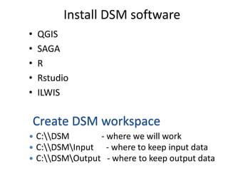
  • 1. Install DSM software • QGIS • SAGA • R • Rstudio • ILWIS Create DSM workspace  C:DSM - where we will work  C:DSMInput - where to keep input data  C:DSMOutput - where to keep output data
  • 3. Example: Soil profile data from ISRIC
  • 4. Explore data and develop database • Import maps in QGIS and explore • Open MS Office data and explore • Scan hard copy maps and explore • Exploration – Legend – Contents (codes, classes, missing, range, etc.) – Georeferencing (Projection, coordinates, tie-points) – Documentation (report, methods, etc) • Classify data quality
  • 5. Building geo-database • Geo-reference the images • Digitize boundaries where possible • Enter/convert the point-data into CSV database • Re-project the maps to common datum – MODIS (in Sinusoidal-Sphere projection) : convert +proj=sinu +lon_0=30 +x_0=0 +y_0=0 +a=6370997 +b=6371000 +units=m +no_defs • Save all the project/database in one folder
  • 6. Example geo-database • Use tie-points to georeference the jpeg image • Digitize and build geo-database where possible (and clean using topology clean tool) • Import other layers (environmental factors) • Import MS Excel files into geo-database (use CSV) and convert to shapefiles • Document all the data in the database
  • 7. Assignment: Building geo-database for DSM application-STEP 1 • Use your own data • Explore the data • Follow the steps for building the geo-database • Build the DSM geo-database • Save the database (C:DSMInput) • Remember to hand in your work by Next Morning before start of the session