
Recommended
Recommended
More Related Content
What's hot
What's hot (20)
Similar to Madurai temple town.pptx
Similar to Madurai temple town.pptx (20)
Recently uploaded
Recently uploaded (20)
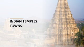
Madurai temple town.pptx
- 2. TEMPLE TOWN - MADURAI • Madurai -olderly known as Koodal • Become the Capital of Pandyan Kingdom on 600 BC • Megasthenes visited the city being referred to as ‘Methora’ • After Sangam age, most of the present day Tamil Nadu, including Madurai came under the rule of the Kalabhras Dynasty which were ousted by the Pandyas around 550 BC. • The Pandyas were in their turn removed from power by the Chola dynasty during the early 9th Century.
- 3. • City planning according to Rajdhani plan Described in Manasara. • Manasara It is one of the silpasastra. • Fivefold concentric rectangular formation with Meenakshi temple at the very centre point. • City planned with Basaars, broad roads with high and luxurious mansion on both sides. • Temple complex was the Focal point. • Combination of Concentric street pattern TEMPLE TOWN - MADURAI
- 4. •The streets concentric to the temple complex formed the major streets viz., Chithirai Street, Avani Moola Streets and Masi Street. •The developments within and beyond these streets are on an irregular pattern. A definite hierarchy of street pattern was adopted with the width of the streets decreasing as they branched out, ending up in stone paved streets and lanes. •The width of some being just 0.6m. The entire City was enclosed within the fort wall and surrounded by the moat •The fort walls have been razed down and the filled up form the present day Veli Street. TEMPLE TOWN - MADURAI
- 6. TEMPLE TOWN - MADURAI MADURAI - EVOLUTION
- 7. TEMPLE TOWN - MADURAI 1900 1937
- 8. TEMPLE TOWN - MADURAI ELEMENTS OF PLANNING OF OLDER CORE CITY •Meenakshi temple’s planning was the basis of core city’s planning. It extends from the temple till periphery. •Residences with its traditional planning with courtyards and thinnai helps with the hot weather and provides natural surveillance.
- 10. •The settlement pattern of Madurai is planned according to the ancient system of town planning which is based on case and occupational hierarchies. •The map shows the present settlement and pattern and its relevance with the ancient town planning system ancient. •South Indian temple towns are designed by placing the temple complex at the centre which concentric rectangle pattern of streets around. •This can be seen in another southern temple Srirangam also. TEMPLE TOWN - MADURAI
- 11. • Older core city was a fortified settlement on the southern banks of river Vaigai, few scattered buildings and agricultural farm lands outside the fort area. After the 1900s, the city’s growth started towards Northern part with the advent of the railways and other public services. The administration centre of the city also shifted to the Northern part as a decongestion measure. While the Northern part of the city provides administrative and civic services, the South city provides commercial and socio-cultural activities. MADURAI - URBAN GROWTH AND EVOLUTION There is a distinct demarcation in the city as Old and New city, North and South city.
- 13. TEMPLE TOWN - SRIRANGAM ●Vellithirumutha gramam. An island connected with trichy. ●Famous for the population of Sri Vaishnavites. One of the Divya prabandham temple ●Dravidian Style of Architecture ●The temple complex is the biggest functioning Hindu temple in the world as it covers an area about 6,79,000 sq ft with a perimeter of 4km ●The complex is composed of 7 concentric walled sections and 21 magnificent towers or gopurams. ●Raja gopuram is 235ft -72m tall built in 8 years by Ahobila Mutt ●Tallest Gopuram in the asia. ●The 1000 pillar hall is made of granite and was constructed in Vijayanagara period 1336 -1565 on