SlideShare a Scribd company logo
1 of 7
BALANCED ROCK (I)
(Buhl, Twin Falls County, Idaho)
Dr. R.M. de Jonge ©, drsrmdejonge@hotmail.com
July, 2013
Summary
Balanced Rock is generally considered as a geological anomality. However, it appears the
Rock was dressed to shape in antiquity. It strongly resembles the shape of the continent of
Africa. The 40th latitude line connects this continent with North America. The monument
tells the story of the Egyptian discovery of America via the Bering Sea by king Menkaure of
the Fourth Dynasty (c.2570 BC). The four Atlantic crossings were subsequently discovered
by three kings of the Fifth Dynasty. It appears the carved Rock dates from the 12th or 13th
Dynasty (c.1800 BC).
Introduction
“Balanced Rock” is located in south Idaho, west of the Rocky Mountains. The Site is situated
10 miles (16 km) WSW of Buhl, Twin Falls County, a town of about 4,000 inhabitants. It is in
the Salmon Falls Creek Canyon, 3,800 feet (1,160 meters) above sea level, on top of a bed-
rock formation some 200 feet (60 m) above the canyon floor.
It is usely described as a natural Rock, over 48 feet (15 m) tall and equally wide, which balan-
ces on a pedestal only 3 feet (1 m) long, and 17 inches (0.5 m) wide. The rock type appears to
be rhyolite, and it weighs about 40 tons. - Fig.1 shows the Rock is highly asymmetrical, and it
is quite amazing this wind-carved formation has never toppled from its stand.
Fig.1 Balanced Rock in south Idaho (c.1800 BC)
(Courtesy: Tom Foster, Ref.1)
Egyptian discovery of America
King Menkaure
Balanced Rock closely resembles a coast map of the continent of Africa (Fig.1). The Medi-
terranean Sea is in the North, the Red Sea in the North-East, the Indian Ocean in the East, and
the Atlantic Ocean in the West. Egypt is located in the north-eastern corner of Africa, where
the Med meets the Red Sea.
It is quite obvious the ancient Egyptians tried to use this Rock as a monument for their early
discovery of America. - Balanced Rock, Idaho, is located at 42.5°N. The North Cape of Afri-
ca is located near the town of Bizerte, Tunesia, at 37.5°N (Fig.1). Latitudes were already
known c.4800 BC, as shown by the monument of Barnénez, Brittany, France.
The average latitude of exactly 40°N refers to the 40th latitude line, which connects both con-
tinents. It strongly suggests America was discovered in the Fourth Dynasty. Tens of megali-
thic monuments all over the World tell the same story!
It happened at the southern Aleutian islands, at the south side of the Bering Sea, at the com-
plementary latitude of 90-40= c.50°N by the 5th king Menkaure (Mycerinos, c.2580-2562 BC)
of this dynasty. In antiquity the use of complementary latitudes was very common.
Balanced Rock, ID, is located 42.5-37.5= 5° above the North Cape of Africa, confirming it.
The length of the 40th latitude line from coast to coast across North America equals 50°, con-
firming it, again. - The exact latitude of the southern Aleutian islands is 1° higher, at 50+1 =
51°N.
The holy Arctic Circle, at 67°N, is the northernmost line the Sun still shines at midwinter day
(Sun religion). It shows king Menkaure returned via the Bering Strait, 1° below it, at 67-1=
66°N. He discovered this crossing, too, 66-51= 15° above the southern Aleutian islands. - The
two mentioned continents, Africa and North America, confirm this King discovered two cros-
sings. (Refs.3-6)
Crossings of the Atlantic
King Sahure
The southern Cape Verde islands, off shore West Africa (Fig.1), are situated at 15°N (see abo-
ve). The Nile Delta (Fig.1), at 30°N, encodes the sailing direction of the Southern Crossing of
the Atlantic, with the wind and the current, 30° SSW. The 50th latitude line near the southern
Aleutians encodes the point of arrival, Cape São Rock (the Holy Rock), Brazil, at 5°S, as well
as the Fifth Dynasty. The sailing distance of 2 Moiras, or 20°, encodes the 2nd king Sahure
(c.2510-2498 BC), who discovered it. The two mentioned continents, Africa and North Ame-
rica, confirm this discovery by the 2nd king. - Cape Guardafuy, the east cape of Africa near
the town of Caluula (Fig.1), at 12°N, confirms his 12 years of reign.
This King had to return. Balanced Rock is located at c.43°N. It shows he returned from Cape
Race, the SE Cape of Newfoundland, at the complementary latitude of 90-43= 47°N. The ini-
tial sailing direction, with the wind and the current, is 20° ESE, and the sailing distance is 2
Moiras, or 20°, to the two islands of the West Azores. It illustrates this Crossing was disco-
vered by this 2nd king, as well.
The West Azores are located at the complementary latitude of the southern Aleutian islands,
at 90-51= 39°N. The five islands of the Central Azores, at 38°N, confirm it happened in the
Fifth Dynasty. Its complementary latitude of 90-38= 50+2= 52°N confirms the two southern
crossings of the Ocean were discovered by the 2nd king Sahure of this dynasty.
The Strait of Gibraltar is located in the north-western corner of Africa (Fig.1), at 36°N, where
the Med meets the Atlantic. The meridian, or north-south line of Balanced Rock runs south to
Lake Mead (Colorado River), at 36°N, confirming it. It refers to the circumference of the pla-
net Earth of 36 Moiras, or 360° (1 Egyptian Moira= 10 moiras= 10°). It shows the 2nd king
Sahure was the first king who circumnavigated the planet Earth. (Refs.7-11)
King Neferirkare
The Nile Delta is located at 30°N (Fig.1). It encodes the Northern Crossing of the Ocean from
the Shetland Islands, via the South Cape of Greenland, to Cape Chidley, Canada, at the com-
plementary latitude of 90-30= 60°N. It was discovered by the 3rd king Neferirkare (c.2498-
2478 BC). So, the third crossing of the Ocean was discovered by this 3rd king. – The meridian
of Balanced Rock runs to the coast of the North Arm of Great Slave Lake, Canada, 62.5-42.5
= 20° above the Site, which confirms the 20 years of reign of this King.
King Unas
The last discovered crossing starts at Abaco Island, northern Bahama’s, 3° below the Missis-
sippi Delta, at 30-3= 27°N. The 2nd king Sahure (c.2510-2498 BC) reigned for 12 years. It
shows the sailing distance to Bermuda, at 30+2= 32°N, was 12 moiras, or 12°. This island is
located 9° above the holy Tropic of Cancer, at 23+9= 32°N. At midsummer day the Sun is
there at right angles above (Sun religion).
It shows the Crossing from Bermuda to the nine islands of the Azores was discovered by the
9th and last king Unas (c.2403-2370 BC) of this dynasty. The 40th latitude line between Afri-
ca and North America (Fig.1) confirms this fourth King. The three island groups of the Azo-
res (the East, Central, and West Azores) encode the long sailing distance, with the wind and
the current: 3 Moiras, or 30°.
The 2nd king Sahure of the Fifth Dynasty sailed from the five islands of the Central Azores to
the two islands of Madeira, at 38-5= 33°N. Their latitude encodes the 33 years of reign of
king Unas (c.2403-2370 BC). He discovered the island of Bermuda, 50-32= 18° below the 50-
th latitude line, confirming the 18 years of reign of king Menkaure (c.2580-2562 BC), who
discovered America.
The 40th latitude line between Africa and North America plays an important role, because it
honors the four Egyptian Kings who were involved in the discovery of America. However, it
also celebrates the four discovered crossings of the Atlantic Ocean. (Refs.12-17)
Fig.2 The 5th king Menkaure (c.2580-2562 BC) of the Fourth Dynasty, who discovered
America via the Bering Sea. (Boston Museum of Fine Arts)
Religion
The 18 years of reign of king Menkaure refer to the ancient civilization around the south point
of the Gulf of Campeche, Mexico, at 18°N. It was the place where the Olmec civilization star-
ted, the holiest place of the America’s. It is the center of the Underworld, “the Realm of the
Dead, at the other side of the waters (the Ocean), in the land where the Sun sets (America).”
It is located at half the latitude of the Strait of Gibraltar, at 36/2= 18°N. It is the center of the
Land of Punt, at a symbolic distance of half the circumference of the planet Earth, 18 Moiras,
or 180° from the Land of the Living (Egypt). The ancient Egyptian “Book of the Dead” con-
tains c.180 Spells for the Afterlife, confirming it. It is the oldest book on Earth. (Refs.18-33)
Date
Balanced Rock is usely considered to be a completely natural, wind-carved rock formation, a
geological anomality. However, we believe this is not true. It appears in
antiquity the original rock was modified for its aimed function as a
monument. At a variety of places rock was re-moved, especially at the base,
with the goal to dress it in the shape of a coast map of the con-tinent of
Africa. - What might be the date of this carved Rock?
North and South America were colonies of Egypt between c.2500 and 1200 BC. Together,
they formed the empire of Atlantis. It was the time period of the metal trade
from America to the Old World. Copper from Upper Michigan and Isle
Royale, and tin, silver and gold from Bolivia were shipped across the Ocean
to the Mediterranean (Fig.1). Balanced Rock dates from this time period.
In an other article we will show Balanced Rock also tells the story of the Comet Catastrophe
(or Flood) in the Sixth Dynasty (c.2344 BC). Megalithic monuments of this type were usely
constructed in the Twelfth Dynasty. The Site is located 42.5-30= 12.5° above the Nile Delta,
encoding a probable date in the 12th or 13th Dynasty (c.2007-1794 BC or c.1793-1641 BC)
(Middle Kingdom). So, the estimated date is c.1800 BC.
References
1. Tom Foster, Website: http://hugefloods.com/Bonneville.html
2. Molina, Y., FB Group: “Mystery Mountain, West Virginia”
3. De Jonge, R.M., and Wakefield, J.S., How the SunGod Reached America c.2500 BC, A Guide to Megalithic
Sites, 2002 (ISBN 0-917054-19-9). Available: MCS Inc., Box 3392, Kirkland, Wa 98083, also on CD.
Website: www.howthesungod.com
4. Wakefield, J.S., and De Jonge, R.M., Rocks & Rows, Sailing Routes across the Atlantic and the Copper
Trade, MCS Inc, 2010 (ISBN 0-917054-20-2). Available: MCS Inc, Box 3392, Kirkland, Wa USA 98083.
Website: www.rocksandrows.com
5. De Jonge, R.M., Website: www.slideshare.net/rmdejonge
6. Pellech, Chr., Website: www.migration-diffusion.info
7. De Jonge, R.M., “The Discovery of Three Continents (Santo Stefano, North Sardinia, Italy, c.2300 BC)”, An-
cient American, Vol.12, No.76, pgs.28-29 (2007), Ref.5.
8. De Jonge, R.M., “Houghton’s Petroglyph (Copper Country, Michigan, 2500-1200 BC)” (2009), Ref.5.
9. De Jonge, R.M., “The Mystic Symbol, mark of the Michigan Mound Builders” (2009), Ref.5.
10. De Jonge, R.M., “A Sword for America (Kirkburn, East Yorkshire, England, c.250 BC)” (2009), Ref.5.
11. De Jonge, R.M., “The Battersea Shield (River Thames, London, c.190 BC)” (2009), Ref.5, to be published.
12. De Jonge, R.M., and Wakefield, J.S., “Discovery of the Islands in the Ocean (Cairn T, Loughcrew, Co.
Meath, Ireland, c.3200 BC)” (2011), Ref.5.
13. De Jonge, R.M., and Wakefield, J.S., "The Passage Grave of Karleby, Encoding the Islands Discovered in the
Ocean, c.2950 BC", Migration & Diffusion, Vol.5, No.18, pgs.64-74 (2004), Ref.6.
14. De Jonge, R.M., and Wakefield, J.S., "The Three Rivers Petroglyph, A Guide-post for River Travel in Ame-
rica", Migration & Diffusion, Vol.3, No.12, pgs.74-100 (2002), Ref.6.
15. De Jonge, R.M., and Wakefield, J.S., “A Nautical Center for Crossing the Ocean, America’s Stonehenge,
New Hampshire, c.2200 BC”, Migration & Diffusion, Vol.4, No.15, pgs.60-100 (2003), Ref.6.
16. De Jonge, R.M., “Stonehenge, Monument for the Discovery of America (Salisbury Plain, South England,
c.2000 BC)” (2011), Refs.5,6.
17. De Jonge, R.M., “Tripod Rock, Pyramid Mountain (Morris County, New Jersey, c.1900 BC)” (2011), Refs.-
5,6.
18. De Jonge, R.M., “The Comet Catastrophe of c.2345 BC”, (sixteen articles),
Webpage: http://www.barry.warmkessel.com/dejonge.html
19. De Jonge, R.M., “Gold Ring (Grand Canyon, Arizona, c.1450 BC)” (2010), Ref.5.
20. De Jonge, R.M., “Sentinel Rock, Vermont (Discovery of America and Biblical Flood, c.1900 BC)” (2011),
Refs.5,6.
21. De Jonge, R.M., “Oil City Glyphs (Pennsylvania, c. 2000 BC)” (2012), Ref.5.
22. Rydholm, C.F., Michigan Copper, The Untold Story, Winter Cabin Books, Marquette, 2006 (ISBN 0-
9744679-2-8).
23. De Jonge, R.M., “Megaliths of Arrowhead Region I (Minnesota, c.1900 BC)” (2012), Ref.5.
24. De Jonge, R.M., “Megaliths of Arrowhead Region II (Minnesota, c.1900 and c.770 BC BC)” (2012).
25. De Jonge, R.M., “Grave Creek Mound (I) (Moundville, Marshall County, WV)” (2012), Ref.5.
26. De Jonge, R.M., “Grave Creek Mound (II) (c.720 BC, Moundville, Marshall County, WV)” (2012), Ref.5.
27. De Jonge, R.M., “Copper Spear Tip, (Crow Wing County, MN, c.1500 BC)”, (2013), Ref.5.
28. De Jonge, R.M., “Ancient Stone Balls, (Redwood Co. and Stevens Co., MN, c.1900 BC)”, (2013), Ref.5.
29. De Jonge, R.M., “Circle Cross Symbol, (Copper Harbor, Upper Michigan, c.1900 BC)”, (2013), Ref.5.
30. Faulkner, R.O., The Ancient Egyptian Book of the Dead, British Museum Press (2010) (ISBN 978-0-7141-
1992-2).
31. Robin Mueller, FB Group: “Old Copper Complex and Ancient Waterways America”.
32. Susan English, Yahoo Group of the Ancient Waterways Society.
33. De Jonge, R.M., http://independent.academia.edu/ReinoudDeJonge

More Related Content

What's hot

What's hot (19)

MONKS MOUND, CAHOKIA, ILLINOIS
MONKS MOUND, CAHOKIA, ILLINOISMONKS MOUND, CAHOKIA, ILLINOIS
MONKS MOUND, CAHOKIA, ILLINOIS
 
GRAVE CREEK MOUND II, WV
GRAVE CREEK MOUND II, WVGRAVE CREEK MOUND II, WV
GRAVE CREEK MOUND II, WV
 
DISCOVERY OF THREE CONTINENTS, SARDINIA
DISCOVERY OF THREE CONTINENTS, SARDINIADISCOVERY OF THREE CONTINENTS, SARDINIA
DISCOVERY OF THREE CONTINENTS, SARDINIA
 
FOUR CHAMBERS (I), CO
FOUR CHAMBERS (I), COFOUR CHAMBERS (I), CO
FOUR CHAMBERS (I), CO
 
LONGYOU CAVES, CHINA
LONGYOU CAVES, CHINALONGYOU CAVES, CHINA
LONGYOU CAVES, CHINA
 
EARLY DISCOVERY OF THE WORLD (I)
EARLY DISCOVERY OF THE WORLD (I)EARLY DISCOVERY OF THE WORLD (I)
EARLY DISCOVERY OF THE WORLD (I)
 
SPHERICAL ROCK, WI
SPHERICAL ROCK, WISPHERICAL ROCK, WI
SPHERICAL ROCK, WI
 
PREHISTORY OF AZORES (3600-1200 BC)
PREHISTORY OF AZORES (3600-1200 BC)PREHISTORY OF AZORES (3600-1200 BC)
PREHISTORY OF AZORES (3600-1200 BC)
 
CIRCLE CROSS CARVING, MI
CIRCLE CROSS CARVING, MICIRCLE CROSS CARVING, MI
CIRCLE CROSS CARVING, MI
 
EARLY DISCOVERY OF THE WORLD (II)
EARLY DISCOVERY OF THE WORLD (II)EARLY DISCOVERY OF THE WORLD (II)
EARLY DISCOVERY OF THE WORLD (II)
 
Lennox head 5
Lennox head 5Lennox head 5
Lennox head 5
 
DISCOVERY OF AMERICA
DISCOVERY OF AMERICADISCOVERY OF AMERICA
DISCOVERY OF AMERICA
 
ITA LETRA, PARAGUAY
ITA LETRA, PARAGUAYITA LETRA, PARAGUAY
ITA LETRA, PARAGUAY
 
MEGALITHIC WRITING (II), ORKNEY'S
MEGALITHIC WRITING (II), ORKNEY'SMEGALITHIC WRITING (II), ORKNEY'S
MEGALITHIC WRITING (II), ORKNEY'S
 
MEGALITHIC WRITING (I), ORKNEY'S
MEGALITHIC WRITING (I), ORKNEY'SMEGALITHIC WRITING (I), ORKNEY'S
MEGALITHIC WRITING (I), ORKNEY'S
 
OMAK ROCK (II), WA
OMAK ROCK (II), WAOMAK ROCK (II), WA
OMAK ROCK (II), WA
 
HOUGHTON’S PETROGLYPH
HOUGHTON’S PETROGLYPHHOUGHTON’S PETROGLYPH
HOUGHTON’S PETROGLYPH
 
Eyb5
Eyb5Eyb5
Eyb5
 
A SWORD FOR AMERICA
A SWORD FOR AMERICAA SWORD FOR AMERICA
A SWORD FOR AMERICA
 

Similar to BALANCED ROCK (I), ID (13)

ANGLO-SAXON ARTIFACTS
ANGLO-SAXON ARTIFACTSANGLO-SAXON ARTIFACTS
ANGLO-SAXON ARTIFACTS
 
COPPER SPEAR TIP, MN
COPPER SPEAR TIP, MNCOPPER SPEAR TIP, MN
COPPER SPEAR TIP, MN
 
INDIAN ROCK HOUSE, ARKANSAS
INDIAN ROCK HOUSE, ARKANSASINDIAN ROCK HOUSE, ARKANSAS
INDIAN ROCK HOUSE, ARKANSAS
 
SWAN STONE, ILLINOIS
SWAN STONE, ILLINOISSWAN STONE, ILLINOIS
SWAN STONE, ILLINOIS
 
GOLD RING, ARIZONA
GOLD RING, ARIZONAGOLD RING, ARIZONA
GOLD RING, ARIZONA
 
BALANCED ROCK (II), ID
BALANCED ROCK (II), IDBALANCED ROCK (II), ID
BALANCED ROCK (II), ID
 
POVERTY POINT, NE LOUISIANA
POVERTY POINT, NE LOUISIANAPOVERTY POINT, NE LOUISIANA
POVERTY POINT, NE LOUISIANA
 
THE BATTERSEA SHIELD (LV)
THE BATTERSEA SHIELD (LV)THE BATTERSEA SHIELD (LV)
THE BATTERSEA SHIELD (LV)
 
MEGALITHS ON ICELAND
MEGALITHS ON ICELANDMEGALITHS ON ICELAND
MEGALITHS ON ICELAND
 
IKOM AND DARDANUS FLOOD
IKOM AND DARDANUS FLOODIKOM AND DARDANUS FLOOD
IKOM AND DARDANUS FLOOD
 
DISCOVERY OF AUSTRALIA
DISCOVERY OF AUSTRALIADISCOVERY OF AUSTRALIA
DISCOVERY OF AUSTRALIA
 
CAHOKIA, ILLINOIS
CAHOKIA, ILLINOISCAHOKIA, ILLINOIS
CAHOKIA, ILLINOIS
 
SERPENT MOUND, OHIO
SERPENT MOUND, OHIOSERPENT MOUND, OHIO
SERPENT MOUND, OHIO
 

More from INSTITUTE OF MEGALITHIC RESEARCH (6)

SAILING FROM NEW ZEALAND TO AUSTRALIA
SAILING FROM NEW ZEALAND TO AUSTRALIASAILING FROM NEW ZEALAND TO AUSTRALIA
SAILING FROM NEW ZEALAND TO AUSTRALIA
 
MAN OF BACKA, SWEDEN
MAN OF BACKA, SWEDENMAN OF BACKA, SWEDEN
MAN OF BACKA, SWEDEN
 
Could it be just a rock?
Could it be just a rock?Could it be just a rock?
Could it be just a rock?
 
RATTLESNAKE DISC (MOUNDVILLE, AL)
RATTLESNAKE DISC (MOUNDVILLE, AL)RATTLESNAKE DISC (MOUNDVILLE, AL)
RATTLESNAKE DISC (MOUNDVILLE, AL)
 
OIL CITY GLYPHS II, PA
OIL CITY GLYPHS II, PAOIL CITY GLYPHS II, PA
OIL CITY GLYPHS II, PA
 
NARRAGANSETT RUNE STONE
NARRAGANSETT RUNE STONENARRAGANSETT RUNE STONE
NARRAGANSETT RUNE STONE
 

Recently uploaded

Advanced Views - Calendar View in Odoo 17
Advanced Views - Calendar View in Odoo 17Advanced Views - Calendar View in Odoo 17
Advanced Views - Calendar View in Odoo 17Celine George
 
“Oh GOSH! Reflecting on Hackteria's Collaborative Practices in a Global Do-It...
“Oh GOSH! Reflecting on Hackteria's Collaborative Practices in a Global Do-It...“Oh GOSH! Reflecting on Hackteria's Collaborative Practices in a Global Do-It...
“Oh GOSH! Reflecting on Hackteria's Collaborative Practices in a Global Do-It...Marc Dusseiller Dusjagr
 
Privatization and Disinvestment - Meaning, Objectives, Advantages and Disadva...
Privatization and Disinvestment - Meaning, Objectives, Advantages and Disadva...Privatization and Disinvestment - Meaning, Objectives, Advantages and Disadva...
Privatization and Disinvestment - Meaning, Objectives, Advantages and Disadva...RKavithamani
 
Sanyam Choudhary Chemistry practical.pdf
Sanyam Choudhary Chemistry practical.pdfSanyam Choudhary Chemistry practical.pdf
Sanyam Choudhary Chemistry practical.pdfsanyamsingh5019
 
Call Girls in Dwarka Mor Delhi Contact Us 9654467111
Call Girls in Dwarka Mor Delhi Contact Us 9654467111Call Girls in Dwarka Mor Delhi Contact Us 9654467111
Call Girls in Dwarka Mor Delhi Contact Us 9654467111Sapana Sha
 
Introduction to ArtificiaI Intelligence in Higher Education
Introduction to ArtificiaI Intelligence in Higher EducationIntroduction to ArtificiaI Intelligence in Higher Education
Introduction to ArtificiaI Intelligence in Higher Educationpboyjonauth
 
Student login on Anyboli platform.helpin
Student login on Anyboli platform.helpinStudent login on Anyboli platform.helpin
Student login on Anyboli platform.helpinRaunakKeshri1
 
Nutritional Needs Presentation - HLTH 104
Nutritional Needs Presentation - HLTH 104Nutritional Needs Presentation - HLTH 104
Nutritional Needs Presentation - HLTH 104misteraugie
 
Presentation by Andreas Schleicher Tackling the School Absenteeism Crisis 30 ...
Presentation by Andreas Schleicher Tackling the School Absenteeism Crisis 30 ...Presentation by Andreas Schleicher Tackling the School Absenteeism Crisis 30 ...
Presentation by Andreas Schleicher Tackling the School Absenteeism Crisis 30 ...EduSkills OECD
 
Introduction to AI in Higher Education_draft.pptx
Introduction to AI in Higher Education_draft.pptxIntroduction to AI in Higher Education_draft.pptx
Introduction to AI in Higher Education_draft.pptxpboyjonauth
 
Hybridoma Technology ( Production , Purification , and Application )
Hybridoma Technology  ( Production , Purification , and Application  ) Hybridoma Technology  ( Production , Purification , and Application  )
Hybridoma Technology ( Production , Purification , and Application ) Sakshi Ghasle
 
Accessible design: Minimum effort, maximum impact
Accessible design: Minimum effort, maximum impactAccessible design: Minimum effort, maximum impact
Accessible design: Minimum effort, maximum impactdawncurless
 
mini mental status format.docx
mini    mental       status     format.docxmini    mental       status     format.docx
mini mental status format.docxPoojaSen20
 
Software Engineering Methodologies (overview)
Software Engineering Methodologies (overview)Software Engineering Methodologies (overview)
Software Engineering Methodologies (overview)eniolaolutunde
 
How to Make a Pirate ship Primary Education.pptx
How to Make a Pirate ship Primary Education.pptxHow to Make a Pirate ship Primary Education.pptx
How to Make a Pirate ship Primary Education.pptxmanuelaromero2013
 
Paris 2024 Olympic Geographies - an activity
Paris 2024 Olympic Geographies - an activityParis 2024 Olympic Geographies - an activity
Paris 2024 Olympic Geographies - an activityGeoBlogs
 
Contemporary philippine arts from the regions_PPT_Module_12 [Autosaved] (1).pptx
Contemporary philippine arts from the regions_PPT_Module_12 [Autosaved] (1).pptxContemporary philippine arts from the regions_PPT_Module_12 [Autosaved] (1).pptx
Contemporary philippine arts from the regions_PPT_Module_12 [Autosaved] (1).pptxRoyAbrique
 

Recently uploaded (20)

Advanced Views - Calendar View in Odoo 17
Advanced Views - Calendar View in Odoo 17Advanced Views - Calendar View in Odoo 17
Advanced Views - Calendar View in Odoo 17
 
“Oh GOSH! Reflecting on Hackteria's Collaborative Practices in a Global Do-It...
“Oh GOSH! Reflecting on Hackteria's Collaborative Practices in a Global Do-It...“Oh GOSH! Reflecting on Hackteria's Collaborative Practices in a Global Do-It...
“Oh GOSH! Reflecting on Hackteria's Collaborative Practices in a Global Do-It...
 
Privatization and Disinvestment - Meaning, Objectives, Advantages and Disadva...
Privatization and Disinvestment - Meaning, Objectives, Advantages and Disadva...Privatization and Disinvestment - Meaning, Objectives, Advantages and Disadva...
Privatization and Disinvestment - Meaning, Objectives, Advantages and Disadva...
 
Sanyam Choudhary Chemistry practical.pdf
Sanyam Choudhary Chemistry practical.pdfSanyam Choudhary Chemistry practical.pdf
Sanyam Choudhary Chemistry practical.pdf
 
Call Girls in Dwarka Mor Delhi Contact Us 9654467111
Call Girls in Dwarka Mor Delhi Contact Us 9654467111Call Girls in Dwarka Mor Delhi Contact Us 9654467111
Call Girls in Dwarka Mor Delhi Contact Us 9654467111
 
Introduction to ArtificiaI Intelligence in Higher Education
Introduction to ArtificiaI Intelligence in Higher EducationIntroduction to ArtificiaI Intelligence in Higher Education
Introduction to ArtificiaI Intelligence in Higher Education
 
Student login on Anyboli platform.helpin
Student login on Anyboli platform.helpinStudent login on Anyboli platform.helpin
Student login on Anyboli platform.helpin
 
Nutritional Needs Presentation - HLTH 104
Nutritional Needs Presentation - HLTH 104Nutritional Needs Presentation - HLTH 104
Nutritional Needs Presentation - HLTH 104
 
Presentation by Andreas Schleicher Tackling the School Absenteeism Crisis 30 ...
Presentation by Andreas Schleicher Tackling the School Absenteeism Crisis 30 ...Presentation by Andreas Schleicher Tackling the School Absenteeism Crisis 30 ...
Presentation by Andreas Schleicher Tackling the School Absenteeism Crisis 30 ...
 
Código Creativo y Arte de Software | Unidad 1
Código Creativo y Arte de Software | Unidad 1Código Creativo y Arte de Software | Unidad 1
Código Creativo y Arte de Software | Unidad 1
 
Mattingly "AI & Prompt Design: The Basics of Prompt Design"
Mattingly "AI & Prompt Design: The Basics of Prompt Design"Mattingly "AI & Prompt Design: The Basics of Prompt Design"
Mattingly "AI & Prompt Design: The Basics of Prompt Design"
 
Introduction to AI in Higher Education_draft.pptx
Introduction to AI in Higher Education_draft.pptxIntroduction to AI in Higher Education_draft.pptx
Introduction to AI in Higher Education_draft.pptx
 
Hybridoma Technology ( Production , Purification , and Application )
Hybridoma Technology  ( Production , Purification , and Application  ) Hybridoma Technology  ( Production , Purification , and Application  )
Hybridoma Technology ( Production , Purification , and Application )
 
Accessible design: Minimum effort, maximum impact
Accessible design: Minimum effort, maximum impactAccessible design: Minimum effort, maximum impact
Accessible design: Minimum effort, maximum impact
 
mini mental status format.docx
mini    mental       status     format.docxmini    mental       status     format.docx
mini mental status format.docx
 
Software Engineering Methodologies (overview)
Software Engineering Methodologies (overview)Software Engineering Methodologies (overview)
Software Engineering Methodologies (overview)
 
How to Make a Pirate ship Primary Education.pptx
How to Make a Pirate ship Primary Education.pptxHow to Make a Pirate ship Primary Education.pptx
How to Make a Pirate ship Primary Education.pptx
 
Mattingly "AI & Prompt Design: Structured Data, Assistants, & RAG"
Mattingly "AI & Prompt Design: Structured Data, Assistants, & RAG"Mattingly "AI & Prompt Design: Structured Data, Assistants, & RAG"
Mattingly "AI & Prompt Design: Structured Data, Assistants, & RAG"
 
Paris 2024 Olympic Geographies - an activity
Paris 2024 Olympic Geographies - an activityParis 2024 Olympic Geographies - an activity
Paris 2024 Olympic Geographies - an activity
 
Contemporary philippine arts from the regions_PPT_Module_12 [Autosaved] (1).pptx
Contemporary philippine arts from the regions_PPT_Module_12 [Autosaved] (1).pptxContemporary philippine arts from the regions_PPT_Module_12 [Autosaved] (1).pptx
Contemporary philippine arts from the regions_PPT_Module_12 [Autosaved] (1).pptx
 

BALANCED ROCK (I), ID

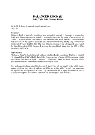
  • 1. BALANCED ROCK (I) (Buhl, Twin Falls County, Idaho) Dr. R.M. de Jonge ©, drsrmdejonge@hotmail.com July, 2013 Summary Balanced Rock is generally considered as a geological anomality. However, it appears the Rock was dressed to shape in antiquity. It strongly resembles the shape of the continent of Africa. The 40th latitude line connects this continent with North America. The monument tells the story of the Egyptian discovery of America via the Bering Sea by king Menkaure of the Fourth Dynasty (c.2570 BC). The four Atlantic crossings were subsequently discovered by three kings of the Fifth Dynasty. It appears the carved Rock dates from the 12th or 13th Dynasty (c.1800 BC). Introduction “Balanced Rock” is located in south Idaho, west of the Rocky Mountains. The Site is situated 10 miles (16 km) WSW of Buhl, Twin Falls County, a town of about 4,000 inhabitants. It is in the Salmon Falls Creek Canyon, 3,800 feet (1,160 meters) above sea level, on top of a bed- rock formation some 200 feet (60 m) above the canyon floor. It is usely described as a natural Rock, over 48 feet (15 m) tall and equally wide, which balan- ces on a pedestal only 3 feet (1 m) long, and 17 inches (0.5 m) wide. The rock type appears to be rhyolite, and it weighs about 40 tons. - Fig.1 shows the Rock is highly asymmetrical, and it is quite amazing this wind-carved formation has never toppled from its stand.
  • 2. Fig.1 Balanced Rock in south Idaho (c.1800 BC) (Courtesy: Tom Foster, Ref.1) Egyptian discovery of America King Menkaure Balanced Rock closely resembles a coast map of the continent of Africa (Fig.1). The Medi- terranean Sea is in the North, the Red Sea in the North-East, the Indian Ocean in the East, and the Atlantic Ocean in the West. Egypt is located in the north-eastern corner of Africa, where the Med meets the Red Sea. It is quite obvious the ancient Egyptians tried to use this Rock as a monument for their early discovery of America. - Balanced Rock, Idaho, is located at 42.5°N. The North Cape of Afri- ca is located near the town of Bizerte, Tunesia, at 37.5°N (Fig.1). Latitudes were already known c.4800 BC, as shown by the monument of Barnénez, Brittany, France. The average latitude of exactly 40°N refers to the 40th latitude line, which connects both con- tinents. It strongly suggests America was discovered in the Fourth Dynasty. Tens of megali- thic monuments all over the World tell the same story!
  • 3. It happened at the southern Aleutian islands, at the south side of the Bering Sea, at the com- plementary latitude of 90-40= c.50°N by the 5th king Menkaure (Mycerinos, c.2580-2562 BC) of this dynasty. In antiquity the use of complementary latitudes was very common. Balanced Rock, ID, is located 42.5-37.5= 5° above the North Cape of Africa, confirming it. The length of the 40th latitude line from coast to coast across North America equals 50°, con- firming it, again. - The exact latitude of the southern Aleutian islands is 1° higher, at 50+1 = 51°N. The holy Arctic Circle, at 67°N, is the northernmost line the Sun still shines at midwinter day (Sun religion). It shows king Menkaure returned via the Bering Strait, 1° below it, at 67-1= 66°N. He discovered this crossing, too, 66-51= 15° above the southern Aleutian islands. - The two mentioned continents, Africa and North America, confirm this King discovered two cros- sings. (Refs.3-6) Crossings of the Atlantic King Sahure The southern Cape Verde islands, off shore West Africa (Fig.1), are situated at 15°N (see abo- ve). The Nile Delta (Fig.1), at 30°N, encodes the sailing direction of the Southern Crossing of the Atlantic, with the wind and the current, 30° SSW. The 50th latitude line near the southern Aleutians encodes the point of arrival, Cape São Rock (the Holy Rock), Brazil, at 5°S, as well as the Fifth Dynasty. The sailing distance of 2 Moiras, or 20°, encodes the 2nd king Sahure (c.2510-2498 BC), who discovered it. The two mentioned continents, Africa and North Ame- rica, confirm this discovery by the 2nd king. - Cape Guardafuy, the east cape of Africa near the town of Caluula (Fig.1), at 12°N, confirms his 12 years of reign. This King had to return. Balanced Rock is located at c.43°N. It shows he returned from Cape Race, the SE Cape of Newfoundland, at the complementary latitude of 90-43= 47°N. The ini- tial sailing direction, with the wind and the current, is 20° ESE, and the sailing distance is 2 Moiras, or 20°, to the two islands of the West Azores. It illustrates this Crossing was disco- vered by this 2nd king, as well. The West Azores are located at the complementary latitude of the southern Aleutian islands, at 90-51= 39°N. The five islands of the Central Azores, at 38°N, confirm it happened in the Fifth Dynasty. Its complementary latitude of 90-38= 50+2= 52°N confirms the two southern crossings of the Ocean were discovered by the 2nd king Sahure of this dynasty. The Strait of Gibraltar is located in the north-western corner of Africa (Fig.1), at 36°N, where the Med meets the Atlantic. The meridian, or north-south line of Balanced Rock runs south to Lake Mead (Colorado River), at 36°N, confirming it. It refers to the circumference of the pla- net Earth of 36 Moiras, or 360° (1 Egyptian Moira= 10 moiras= 10°). It shows the 2nd king Sahure was the first king who circumnavigated the planet Earth. (Refs.7-11) King Neferirkare The Nile Delta is located at 30°N (Fig.1). It encodes the Northern Crossing of the Ocean from the Shetland Islands, via the South Cape of Greenland, to Cape Chidley, Canada, at the com- plementary latitude of 90-30= 60°N. It was discovered by the 3rd king Neferirkare (c.2498- 2478 BC). So, the third crossing of the Ocean was discovered by this 3rd king. – The meridian of Balanced Rock runs to the coast of the North Arm of Great Slave Lake, Canada, 62.5-42.5 = 20° above the Site, which confirms the 20 years of reign of this King.
  • 4. King Unas The last discovered crossing starts at Abaco Island, northern Bahama’s, 3° below the Missis- sippi Delta, at 30-3= 27°N. The 2nd king Sahure (c.2510-2498 BC) reigned for 12 years. It shows the sailing distance to Bermuda, at 30+2= 32°N, was 12 moiras, or 12°. This island is located 9° above the holy Tropic of Cancer, at 23+9= 32°N. At midsummer day the Sun is there at right angles above (Sun religion). It shows the Crossing from Bermuda to the nine islands of the Azores was discovered by the 9th and last king Unas (c.2403-2370 BC) of this dynasty. The 40th latitude line between Afri- ca and North America (Fig.1) confirms this fourth King. The three island groups of the Azo- res (the East, Central, and West Azores) encode the long sailing distance, with the wind and the current: 3 Moiras, or 30°. The 2nd king Sahure of the Fifth Dynasty sailed from the five islands of the Central Azores to the two islands of Madeira, at 38-5= 33°N. Their latitude encodes the 33 years of reign of king Unas (c.2403-2370 BC). He discovered the island of Bermuda, 50-32= 18° below the 50- th latitude line, confirming the 18 years of reign of king Menkaure (c.2580-2562 BC), who discovered America. The 40th latitude line between Africa and North America plays an important role, because it honors the four Egyptian Kings who were involved in the discovery of America. However, it also celebrates the four discovered crossings of the Atlantic Ocean. (Refs.12-17) Fig.2 The 5th king Menkaure (c.2580-2562 BC) of the Fourth Dynasty, who discovered America via the Bering Sea. (Boston Museum of Fine Arts)
  • 5. Religion The 18 years of reign of king Menkaure refer to the ancient civilization around the south point of the Gulf of Campeche, Mexico, at 18°N. It was the place where the Olmec civilization star- ted, the holiest place of the America’s. It is the center of the Underworld, “the Realm of the Dead, at the other side of the waters (the Ocean), in the land where the Sun sets (America).” It is located at half the latitude of the Strait of Gibraltar, at 36/2= 18°N. It is the center of the Land of Punt, at a symbolic distance of half the circumference of the planet Earth, 18 Moiras, or 180° from the Land of the Living (Egypt). The ancient Egyptian “Book of the Dead” con- tains c.180 Spells for the Afterlife, confirming it. It is the oldest book on Earth. (Refs.18-33) Date Balanced Rock is usely considered to be a completely natural, wind-carved rock formation, a geological anomality. However, we believe this is not true. It appears in antiquity the original rock was modified for its aimed function as a monument. At a variety of places rock was re-moved, especially at the base, with the goal to dress it in the shape of a coast map of the con-tinent of Africa. - What might be the date of this carved Rock? North and South America were colonies of Egypt between c.2500 and 1200 BC. Together, they formed the empire of Atlantis. It was the time period of the metal trade from America to the Old World. Copper from Upper Michigan and Isle Royale, and tin, silver and gold from Bolivia were shipped across the Ocean to the Mediterranean (Fig.1). Balanced Rock dates from this time period. In an other article we will show Balanced Rock also tells the story of the Comet Catastrophe (or Flood) in the Sixth Dynasty (c.2344 BC). Megalithic monuments of this type were usely constructed in the Twelfth Dynasty. The Site is located 42.5-30= 12.5° above the Nile Delta, encoding a probable date in the 12th or 13th Dynasty (c.2007-1794 BC or c.1793-1641 BC) (Middle Kingdom). So, the estimated date is c.1800 BC. References 1. Tom Foster, Website: http://hugefloods.com/Bonneville.html 2. Molina, Y., FB Group: “Mystery Mountain, West Virginia” 3. De Jonge, R.M., and Wakefield, J.S., How the SunGod Reached America c.2500 BC, A Guide to Megalithic Sites, 2002 (ISBN 0-917054-19-9). Available: MCS Inc., Box 3392, Kirkland, Wa 98083, also on CD. Website: www.howthesungod.com 4. Wakefield, J.S., and De Jonge, R.M., Rocks & Rows, Sailing Routes across the Atlantic and the Copper Trade, MCS Inc, 2010 (ISBN 0-917054-20-2). Available: MCS Inc, Box 3392, Kirkland, Wa USA 98083. Website: www.rocksandrows.com 5. De Jonge, R.M., Website: www.slideshare.net/rmdejonge 6. Pellech, Chr., Website: www.migration-diffusion.info 7. De Jonge, R.M., “The Discovery of Three Continents (Santo Stefano, North Sardinia, Italy, c.2300 BC)”, An- cient American, Vol.12, No.76, pgs.28-29 (2007), Ref.5. 8. De Jonge, R.M., “Houghton’s Petroglyph (Copper Country, Michigan, 2500-1200 BC)” (2009), Ref.5. 9. De Jonge, R.M., “The Mystic Symbol, mark of the Michigan Mound Builders” (2009), Ref.5. 10. De Jonge, R.M., “A Sword for America (Kirkburn, East Yorkshire, England, c.250 BC)” (2009), Ref.5. 11. De Jonge, R.M., “The Battersea Shield (River Thames, London, c.190 BC)” (2009), Ref.5, to be published. 12. De Jonge, R.M., and Wakefield, J.S., “Discovery of the Islands in the Ocean (Cairn T, Loughcrew, Co. Meath, Ireland, c.3200 BC)” (2011), Ref.5. 13. De Jonge, R.M., and Wakefield, J.S., "The Passage Grave of Karleby, Encoding the Islands Discovered in the Ocean, c.2950 BC", Migration & Diffusion, Vol.5, No.18, pgs.64-74 (2004), Ref.6. 14. De Jonge, R.M., and Wakefield, J.S., "The Three Rivers Petroglyph, A Guide-post for River Travel in Ame- rica", Migration & Diffusion, Vol.3, No.12, pgs.74-100 (2002), Ref.6.
  • 6. 15. De Jonge, R.M., and Wakefield, J.S., “A Nautical Center for Crossing the Ocean, America’s Stonehenge, New Hampshire, c.2200 BC”, Migration & Diffusion, Vol.4, No.15, pgs.60-100 (2003), Ref.6. 16. De Jonge, R.M., “Stonehenge, Monument for the Discovery of America (Salisbury Plain, South England, c.2000 BC)” (2011), Refs.5,6. 17. De Jonge, R.M., “Tripod Rock, Pyramid Mountain (Morris County, New Jersey, c.1900 BC)” (2011), Refs.- 5,6. 18. De Jonge, R.M., “The Comet Catastrophe of c.2345 BC”, (sixteen articles), Webpage: http://www.barry.warmkessel.com/dejonge.html 19. De Jonge, R.M., “Gold Ring (Grand Canyon, Arizona, c.1450 BC)” (2010), Ref.5. 20. De Jonge, R.M., “Sentinel Rock, Vermont (Discovery of America and Biblical Flood, c.1900 BC)” (2011), Refs.5,6. 21. De Jonge, R.M., “Oil City Glyphs (Pennsylvania, c. 2000 BC)” (2012), Ref.5. 22. Rydholm, C.F., Michigan Copper, The Untold Story, Winter Cabin Books, Marquette, 2006 (ISBN 0- 9744679-2-8). 23. De Jonge, R.M., “Megaliths of Arrowhead Region I (Minnesota, c.1900 BC)” (2012), Ref.5. 24. De Jonge, R.M., “Megaliths of Arrowhead Region II (Minnesota, c.1900 and c.770 BC BC)” (2012). 25. De Jonge, R.M., “Grave Creek Mound (I) (Moundville, Marshall County, WV)” (2012), Ref.5. 26. De Jonge, R.M., “Grave Creek Mound (II) (c.720 BC, Moundville, Marshall County, WV)” (2012), Ref.5. 27. De Jonge, R.M., “Copper Spear Tip, (Crow Wing County, MN, c.1500 BC)”, (2013), Ref.5. 28. De Jonge, R.M., “Ancient Stone Balls, (Redwood Co. and Stevens Co., MN, c.1900 BC)”, (2013), Ref.5. 29. De Jonge, R.M., “Circle Cross Symbol, (Copper Harbor, Upper Michigan, c.1900 BC)”, (2013), Ref.5. 30. Faulkner, R.O., The Ancient Egyptian Book of the Dead, British Museum Press (2010) (ISBN 978-0-7141- 1992-2). 31. Robin Mueller, FB Group: “Old Copper Complex and Ancient Waterways America”. 32. Susan English, Yahoo Group of the Ancient Waterways Society. 33. De Jonge, R.M., http://independent.academia.edu/ReinoudDeJonge
  • 7. 15. De Jonge, R.M., and Wakefield, J.S., “A Nautical Center for Crossing the Ocean, America’s Stonehenge, New Hampshire, c.2200 BC”, Migration & Diffusion, Vol.4, No.15, pgs.60-100 (2003), Ref.6. 16. De Jonge, R.M., “Stonehenge, Monument for the Discovery of America (Salisbury Plain, South England, c.2000 BC)” (2011), Refs.5,6. 17. De Jonge, R.M., “Tripod Rock, Pyramid Mountain (Morris County, New Jersey, c.1900 BC)” (2011), Refs.- 5,6. 18. De Jonge, R.M., “The Comet Catastrophe of c.2345 BC”, (sixteen articles), Webpage: http://www.barry.warmkessel.com/dejonge.html 19. De Jonge, R.M., “Gold Ring (Grand Canyon, Arizona, c.1450 BC)” (2010), Ref.5. 20. De Jonge, R.M., “Sentinel Rock, Vermont (Discovery of America and Biblical Flood, c.1900 BC)” (2011), Refs.5,6. 21. De Jonge, R.M., “Oil City Glyphs (Pennsylvania, c. 2000 BC)” (2012), Ref.5. 22. Rydholm, C.F., Michigan Copper, The Untold Story, Winter Cabin Books, Marquette, 2006 (ISBN 0- 9744679-2-8). 23. De Jonge, R.M., “Megaliths of Arrowhead Region I (Minnesota, c.1900 BC)” (2012), Ref.5. 24. De Jonge, R.M., “Megaliths of Arrowhead Region II (Minnesota, c.1900 and c.770 BC BC)” (2012). 25. De Jonge, R.M., “Grave Creek Mound (I) (Moundville, Marshall County, WV)” (2012), Ref.5. 26. De Jonge, R.M., “Grave Creek Mound (II) (c.720 BC, Moundville, Marshall County, WV)” (2012), Ref.5. 27. De Jonge, R.M., “Copper Spear Tip, (Crow Wing County, MN, c.1500 BC)”, (2013), Ref.5. 28. De Jonge, R.M., “Ancient Stone Balls, (Redwood Co. and Stevens Co., MN, c.1900 BC)”, (2013), Ref.5. 29. De Jonge, R.M., “Circle Cross Symbol, (Copper Harbor, Upper Michigan, c.1900 BC)”, (2013), Ref.5. 30. Faulkner, R.O., The Ancient Egyptian Book of the Dead, British Museum Press (2010) (ISBN 978-0-7141- 1992-2). 31. Robin Mueller, FB Group: “Old Copper Complex and Ancient Waterways America”. 32. Susan English, Yahoo Group of the Ancient Waterways Society. 33. De Jonge, R.M., http://independent.academia.edu/ReinoudDeJonge