T10 karuppan sakadevan on land and water management in near east and north africa exec summary
•Download as DOC, PDF•
1 like•331 views


Recommended
Recommended
More Related Content
What's hot
What's hot (20)
Viewers also liked
Viewers also liked (20)
Similar to T10 karuppan sakadevan on land and water management in near east and north africa exec summary
Similar to T10 karuppan sakadevan on land and water management in near east and north africa exec summary (20)
More from NENAwaterscarcity
More from NENAwaterscarcity (20)
Recently uploaded
Recently uploaded (20)
T10 karuppan sakadevan on land and water management in near east and north africa exec summary
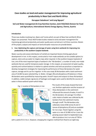
- 1. Case studies on land and water management for improving agricultural productivity in Near East and North Africa Karuppan Sakadevan1 and Long Nguyen1 Soil and Water management & Crop Nutrition Section, Joint FAO/IAEA Division for Food and Agriculture, International Atomic Energy Agency, Vienna, Austria Introduction Three case studies involving Iran, Qatar and Tunisia which are part of Near East and North Africa Region are presented. These IAEA funded studies related to land and water management for improving agricultural productivity and water quality were carried out in all three countries. Details of the project, outputs and impacts on land and water resources are provide below: 1. Iran: Optimizing the capture and storage of water using farm wetlands for improving rice productivity in the southern Caspian lowlands Water scarcity and uneven distribution of rainfall are important factors limiting agricultural development in Iran. In this respect, constructed or man-made wetlands can be suitable options to capture, store and use water to irrigate crops when required. In the southern Caspian lowlands of Iran, one of the most important types of wetland is the "Ab-bandans", a number of small, man-made wetlands that are used for temporary water storage. In this respect, an assessment of water quality, quantity and nutrient balance in relation to upland activities and land use practices is important to develop management strategies for improving the performance of these Ab-bandans for water capture, storage and its use for irrigation. In this case study 30 Ab-bandans with a total catchment area of 14,583 ha were selected (Fig. 1). Water, nitrogen (N) and phosphorus (P) balances in these Ab-bandans were quantified by measuring water, N and P inputs and outputs to these Ab-bandans. In addition, stable isotopic signatures of hydrogen and oxygen were used to identify the sources of water in these wetland system which helps. The results of the study showed that land use, fertilizer application and the location of these Ab-bandans in the catchment influenced the amount of water, N and P in the Ab-bandans. On average 7.6 million cubic meters of water was collected by Ab- bandans from the catchment mainly through runoff. The Ab-bandans also collected a total of 86 tonnes N and 17 tonnes of phosphorus (P) and are available for rice crops. Flood irrigation using this water at a rate of 10 000 m3 ha-1 over the growing season (April to September) was able to produce rice in an area of 730 ha with a yield of 3.5 t ha-1. However, changing the irrigation method from flood to an eight-day Fig. 1. Location of Ab-bandans in Iran
- 2. irrigation interval was able to cultivate 1 500 ha with a similar yield and a significantly increased water use efficiency and reduced energy use (Fig. 2). Fig.2. Influence of irrigation methods on (a) amount of water used and (b) total rice production of Ab-Bandans The stable isotopic signatures of water showed that these Ab-bandans do not receive sufficient inputs of water (runoff or groundwater discharge) to minimize the effects of summer evaporation and irrigation requirements. Run-off from precipitation (rainfall and snow melt) during autumn and winter (September to March) was the main contributor to the Ab-bandan water. These results will be useful for improving water management in these Ab-bandans. 2. Qatar: Changing Sabkha’s into potential farmlands for enhancing livestock production and land and water resources protection Sabkhas are among the most degraded lands in Qatar with soil salinity (electrical conductivity, EC=110 dS/m) greater than the salinity of sea water. These Sabkhas also have saline groundwater (EC>95 dS/m) within the top one meter of the surface. The soils are characterised by poor organic matter and lack of essential macro and micro nutrients with the soil profiles mostly consist of calcium carbonate and gypsum. Farming in Sabkhas is extremely difficult and farmers ignore these lands for cultivation. With relatively high calcium carbonate (12 to 17%) and gypsum (3 to 9%) these soils are loose, sandy gravels and can be susceptible to both wind and water erosion. An estimated 300 agricultural farms have already been abandoned due to high salt concentration of the soil. Currently the cultivated land in Qatar accounts for about 8000 ha and it is virtually impossible to do agriculture without irrigation. With an extremely unpredictable, highly erratic, and low intensity rainfall both in time and space, surface water is not considered reliable for supplementing irrigation and managing agriculture. Therefore all irrigation water is extracted from groundwater with a crop water use efficiency of less than 45%. The continuous use of saline groundwater also led to increased salinization of the soil and groundwater and agricultural lands are continuously being abandoned. In this project, an integrated approach to water management was successfully introduced in which salt affected soils, saline water, treated sewage water and drip irrigation technology were used to grow salt tolerant vegetables and fodder crops for animals. Results showed that the introduction of integrated water management in these salt affected soils saved water by 20-30% and reduced the overall need of ground water for irrigation and reduced salt input by 50-60%. In addition, up to 35 tonnes/ha biomass can be produced through this integrated approach. The nutrient contained in the treated sewage water (nitrogen and phosphorus) will enhance soil fertility of these Sabkhas. The soil quality will also be significantly improved through the
- 3. addition of organic matter present in the treated sewage water which binds the soil particles together and provide a healthy environment for vegetation establishment. The Qatar Ministry of Environment is planning to use about 100 million m3 of saline groundwater mixed with 60 million m3 of treated sewage water to irrigate about 80,000 ha of coastal and inland Sabkhas that are currently rated as unsuitable for cultivation. This will potentially increase the arable land in Qatar from 8,000 to 91,000 ha (Fig. 3). Fig. 3. A deserted land (a) has been converted into a fertile cropland (b) 3. Tunisia: Enhancing water harvest through land and water conservation measures to improve agricultural productivity and reduce nutrient pollution This case study aimed at enhancing soil, water and nutrient conservation of the hill farm pond in the Kamech Catchment located at the northwest mountains of the peninsula of Cap Bon, Eastern Tunisia. Irregular water availability is one of the major constraints for agricultural production and socioeconomic development in Tunisia. Small hill ponds are considered as an important part of water resources conservation strategies and had been widely build for various purposes including underlying groundwater recharge and providing surface water for local farming needs. Kamech catchment (265 ha) with a hilly landscape is a representative of this region. It represents a headwater catchment of one of the main surface water resources of the Cap Bon area, the Lebna wadi (218 km²) that runs in to a dam of 24.7 million cubic meters (Fig.4). Optimizing water conservation in the Kamech farm pond helps improve water quality and quantity of Lebna Wadi that is used for agricultural irrigation. Stable isotopic signatures of hydrogen and oxygen were used to identify sources of water to the farm pond. Similarly cations and anions in soil and water in and around the farm pond were used to characterise nutrient retention and source of nutrients to the farm pond. Fig. 4. Kamech Lake and vegetable farming in the Kamech catchment a b
- 4. Results of isotopic signatures of hydrogen and oxygen and water balances for the farm pond showed that the farm pond is a major source of water for groundwater recharge. For an initial pond volume of 46,780 m3 approximately 85,000 m3 of pond water was recharged to the groundwater between September 2009 and August 2010. However, during the dry period the groundwater discharges approximately 6,600 m3 suggesting that the farm pond is an important water conservation area that provides sufficient irrigation water for crops during the growing period and enhance the quantity and quality of downstream water. The isotopic signatures of different sources of water in the catchment (Table 1) showed that stream flow have the same range as those of rainfall indicating that direct run-off from rainfall is the major contributor to stream flow. Isotopic signatures along with water balance calculations indicate that run-off from the catchment is the major source (>90%) of water to the farm pond. Table 1. Isotopic signatures of various source waters in the Kamech catchment Isotope Rainfall Stream flow Farm Pond Run-off δ18 O -14 to 0.1 -7 to +3 -4 to +5 -6 to -3 δ2 H -89 to +5 -37 to +3 -199 to +219 Water quality monitoring of the piezometers, runoff water, pond water showed that nitrate concentrations remained rather low, particularly in the pond (around 1 mg N/L) which reduces the risk of downstream nitrate pollution. The results from this case study will be useful to develop land and water resources management practices that lead to the capture of entire runoff water generated from the catchment and maximize its use for agricultural activities in the catchment.