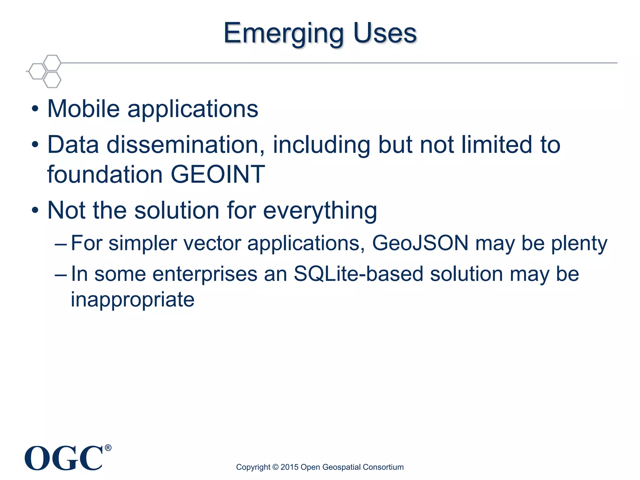
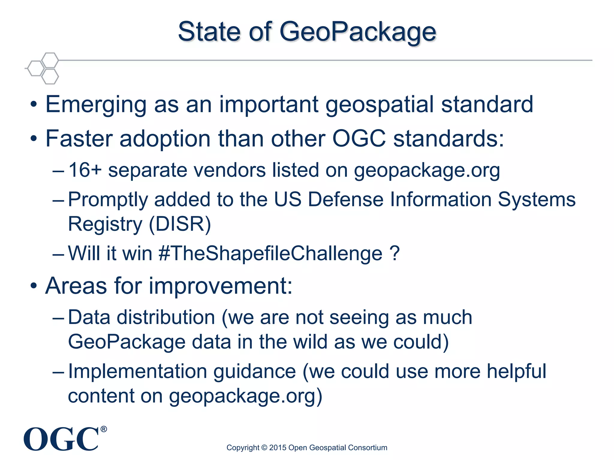
®
Sponsored by
GeoPackage Standards Working Group
98th OGC Technical Committee
Washington, DC USA
08 March 2016
Copyright © 2016 Open Geospatial Consortium
OGC
®
Agenda
• Introductions – JY (10 minutes)
• GeoPackage 1.1 – JY (30 minutes)
• GeoPackage Elevation Extension Interoperability
Experiment – Carl Reed (20 minutes)
• NSG Profile – Roy Rathbun (15 minutes)
• GeoPackage Compliance – Matt Sorenson (10
minutes)
• Future Considerations – JY (10 minutes)
• Implications for an OGC GeoPackage Symbology
Encoding Standard (Discussion Paper) – JY (10
minutes)
Copyright © 2015 Open Geospatial Consortium
OGC
®
Introductions and Roll Call
• Jeff Yutzler, Image Matters LLC (chair)
• Thomas Nierynck, Luciad (vice chair)
Copyright © 2015 Open Geospatial Consortium
OGC
®
Patent Call
INTELLECTUAL PROPERTY RIGHTS POLICY of the Open Geospatial
Consortium, Inc. as approved on 19 December 2008
Please be aware that this meeting is being held under the Intellectual Property
Rights Policy adopted by OGC. If you do not have a copy of this policy, please
see me (the meeting Chair) during this meeting. You may also view and
download a copy of that policy at:
http://portal.opengeospatial.org/files/?artifact_id=32268
At this time, I would ask that anyone in attendance inform me if they are
personally aware of any claims under any patent applications or issued patents
that would be likely to be infringed by an implementation of the standard or other
work product which is the subject of this meeting. You need not be the inventor of
such patent or patent application in order to inform us of its existence, nor will you
be held responsible for expressing a belief that turns out to be inaccurate.
Copyright © 2015 Open Geospatial Consortium
OGC
®
Tile Pyramids
24 zoom levels
GeoPackage:
Raster Maps, Images and Feature Data in One File
Raster Maps:
Small – Large Scale
Imagery
Low – High Resolution
Single File Sqlite Database
containing all data for direct-use on mobile platforms & handheld devices
Feature
Data
OGC
®
What is GeoPackage
• Open format for geospatial information
– Vector geospatial features
– Raster tile matrix sets (pyramids) of imagery and raster
maps at various scales
– Extensions
• SQLite database schema
– Table definitions
– Integrity assertions
– Format limitations
– Content constraints
Copyright © 2015 Open Geospatial Consortium
OGC
®
geopackage.org
• Go here first!
• Web version of specification
• News, implementations, sample data, and FAQ
• Hyperlinks for participants (quickest way to portal,
Wiki, etc.)
Copyright © 2015 Open Geospatial Consortium
OGC
®
GitHub Hosting
• https://github.com/opengeospatial/geopackage
• We’re the first SWG to do as much as possible on GitHub
– Encourages public input
– Provides more modern tools
– Portal, Wiki, and email list still used to conduct SWG business and
to protect participants’ intellectual property
• Issue Tracker
– https://github.com/opengeospatial/geopackage/issues
• http://geopackage.org hosted by GH Pages
– Suggestions welcome
– Pull requests too! See the gh-pages branch.
Copyright © 2015 Open Geospatial Consortium
OGC
®
Vector Tables
• Similar to other relational databases
• Built on existing standards
– OGC Simple Features
– Well-known Binary (WKB)
• Not subject to many of Shapefile’s limitations
Copyright © 2015 Open Geospatial Consortium
OGC
®
Raster Tile Matrix Sets (Pyramids)
Raster Basemaps and Imagery available online from raster
tile servers (WMS, WMTS) and offline in GeoPackages
Raster Maps:
Small – Large Scale
Imagery
Low – High Resolution
Single Raster Tile Server
w/ raster basemap & imagery data.
Tile Pyramid
24 zoom levels
Geopackage w/
Raster Tile Data
Tile Pyramid
24 zoom levels
OGC Web Services
to online clients/apps
WMS, WMTS, WFS
OGC
®
Brief History
• Foundations established prior to 2012
– SQLite3 (sqlite.org) – SpatiaLite (https://www.gaia-gis.it/fossil/libspatialite/home)
– MBTiles (https://github.com/mapbox/mbtiles-spec/blob/master/1.2/spec.md)
• 2012 – Concept initiated by USACE’s AGC/TEC and NGA at
a hosted TEM with FOSS / commercial software developers
– Started as Google Groups; moved to OGC due to need for standards
development structure and potential IPR concerns
• Oct. 2012 – SWG charter established
• 2013-present – OGC Web Services (OWS) Testbeds
– Phase 9 developed initial draft spec; others built prototype applications
• Feb. 2014 – Encoding Standard (1.0) adopted by OGC
– Mandated as of DISR* 14-2
• Early 2015 – Corrigendum (1.0.1) adopted by OGC
Copyright © 2015 Open Geospatial Consortium
* Defense Information Systems Registry
OGC
®
Benefits
• Supports sharing of raster and vector geospatial
information in a single container
• Supports direct use
– Avoid intermediate format translations (extract, transform, load)
– SQLite is a true relational database with built-in indexing
• Platform independent, supporting multiple computing
environments (hardware and operating system)
– Local storage reduces power requirements and supports
disconnected/intermittent/limited connectivity
– Conserves storage space by allowing multiple applications to
access the same data store
Copyright © 2015 Open Geospatial Consortium
OGC
®
Emerging Uses
• Mobile applications
• Data dissemination, including but not limited to
foundation GEOINT
• Not the solution for everything
– For simpler vector applications, GeoJSON may be plenty
– In some enterprises an SQLite-based solution may be
inappropriate
Copyright © 2015 Open Geospatial Consortium
OGC
®
State of GeoPackage
• Emerging as an important geospatial standard
• Faster adoption than other OGC standards:
– 16+ separate vendors listed on geopackage.org
– Promptly added to the US Defense Information Systems
Registry (DISR)
– Will it win #TheShapefileChallenge ?
• Areas for improvement:
– Data distribution (we are not seeing as much
GeoPackage data in the wild as we could)
– Implementation guidance (we could use more helpful
content on geopackage.org)
Copyright © 2015 Open Geospatial Consortium
OGC
®
GeoPackage Implementation Examples
• GDAL
• Luciad Lightspeed, Mobile, and Fusion
• QGIS
• Esri ArcGIS (10.2.2 for vector, 10.3 for tiles)
• NGA
• SpatiaLite (4.2.0)
• GeoServer
• Compusult
• GeoTools
• US Army ERDC
• Envitia MapLink
• Terrago (GeoPDF)
OGC
®
GeoPackage 1.1
• The SWG has developed a Technical Amendment
to the GeoPackage Encoding Standard
“Where…an OGC Standard is used…but technical changes are
needed, a deliverable may be proposed for amendment. An
amendment alters and/or adds to an existing OGC standard [and
results] in a new version number of the document. An amendment
may consist of additional reference examples, use cases, schema
changes, and other normative and informative content or
clarifications.” (http://docs.opengeospatial.org/pol/05-020r20/05-
020r20.html#125)
• Technical Amendment – more than corrigenda, but
less than a completely new edition of the standard.
Copyright © 2015 Open Geospatial Consortium
OGC
®
GeoPackage 1.1 (continued)
• Goal: Improve the standard (especially readability
and interoperability) without harming existing
implementations
• Requires:
Release Notes (15-123r1 posted on Pending
Documents)
SWG Approval
OGC Architecture Board review and approval
– IPR review period
– TC Vote (at TC meeting or by e-vote)
• The plan is for the vote to occur this week.
Copyright © 2015 Open Geospatial Consortium
OGC
®
Review of Substantive Changes
• All work was done in GitHub (see geopackage.org)
• #102 – Add REQ 45 to describe tile matrix width
and height to eliminate interoperability failure
• #132 – Collapse all extensions under Annex F. for
improved readability
• #137 – Add new extension for CRS WKT support
(OGC 12-063r5)
• #147 – Demote metadata / schema to extensions
• #130 – Fix casing of column names for Schema
• #189 – Update Application ID to 1.1
Copyright © 2015 Open Geospatial Consortium
OGC
®
Requirement 45
• Interoperability issue discovered during
GeoPackage Plugfest (2014-5)
– Tile numbering was inconsistent between
implementations – some used “tight” bounds and others
used “potential” bounds to allow sharing between tile sets
• We added the following:
The width of a tile matrix (the difference between min_x and
max_x in gpkg_tile_matrix_set) SHALL equal the product of
matrix_width, tile_width, and pixel_x_size for that zoom level.
Similarly, height of a tile matrix (the difference between min_y
and max_y in gpkg_tile_matrix_set) SHALL equal the product of
matrix_height, tile_height, and pixel_y_size for that zoom level.
Copyright © 2015 Open Geospatial Consortium
This won.
OGC
®
CRS WKT Support
• OGC recently adopted 12-063r5 to address
shortcomings in previous documents
• We want to provide a migration path while not
breaking existing implementations
• Solution: Create a new extension
– Implementations that support this extension add a
column to gpkg_spatial_ref_sys called
“definition_12_063”
– Implementations shall populate both this column and the
original “definition” column
– In some cases, one or the other may be “undefined”
Copyright © 2015 Open Geospatial Consortium
OGC
®
Questions
Copyright © 2015 Open Geospatial Consortium
OGC
®
GPKG-EE IE
Copyright © 2015 Open Geospatial Consortium
OGC
®
NSG Profile
Copyright © 2015 Open Geospatial Consortium
OGC
®
GeoPackage Compliance
Copyright © 2015 Open Geospatial Consortium
OGC
®
Future Considerations
• Over the summer, we conducted an on-line survey to
gauge interest in potential extensions.
• We asked about the following:
– Symbology/Styling
– Multi-Resolution Geometries
– Routing
– New Geometry Types
– New Image Types
– Point Clouds
– UTFGrid
– Synchronization
– Coverages
© 2016 Open Geospatial Consortium 25
OGC
®
Survey Results
Copyright © 2015 Open Geospatial Consortium
OGC
®
Testbed 12
• Testbed 12 is at least partially addressing some of
our proposed topic areas
– Symbology/Styling
– Routing
– Others?
© 2016 Open Geospatial Consortium 27
OGC
®
Testbed 12 Engineering Reports
• As an aside, the Testbed sponsors have requested
that at least three GeoPackage-related
Engineering Reports be produced
– A082 GeoPackage Routing and Symbology
– A083 GeoPackage Mobile Apps Integration
– A085 GeoPackage Change Request Evaluations
• We will bring these to the SWG for review as per
– https://portal.opengeospatial.org/files/?artifact_id=66923
© 2016 Open Geospatial Consortium 28
OGC
®
Implications for a Symbology Extension
• OGC 15-122r1 evaluated this topic and proposed
the following next steps:
– Discuss this proposal in the broader community (outside
the SWG itself) to reach a consensus on approach.
– Prioritize the use cases and pursue design and
reference implementations of the viable use case(s).
– Establish a separate working group, coordinating with
the GeoPackage SWG (composed of interested
GeoPackage SWG members and other stakeholders)
– Analyze applicable informative references to apply
towards defining a draft specification to address viable
use cases identified.
© 2016 Open Geospatial Consortium 29
OGC
®
Motion
• The GeoPackage SWG recommends that OGC
15-122r1 be recommended to the Technical
Committee for release as a Discussion Paper.
– Motion: Jeff Yutzler
– Second: ???
– Discussion?
– Objection to Unanimous Consent?
© 2016 Open Geospatial Consortium 30
OGC
®
Multi-Resolution Geometries
• The SWG has determined that the best way to
address this issue is through data modeling as
opposed to a change to the standard
– https://github.com/opengeospatial/geopackage/issues/77
• In response, we posted the following:
– http://www.geopackage.org/modeling_guidelines.html
© 2016 Open Geospatial Consortium 31
OGC
®
New Geometry Types
• This capability is already available through two
extensions:
– GeoPackage Non-Linear Geometry Types (F.1)
– User Defined Geometry Types Extension of
GeoPackageBinary Geometry Encoding
• At this time we do not have clear guidance on using
these extensions
– https://github.com/opengeospatial/geopackage/issues/173
• There is some concern that these extensions are
unusable in their current form
• We are looking for volunteers
© 2016 Open Geospatial Consortium 32
OGC
®
Other Topic Areas Not Under Development
• New Image Types
• Point Clouds – maybe ask the Point Cloud DWG?
• UTFGrid
• Synchronization
• Coverages
• These can all be handled through extensions…if
we have the will
© 2016 Open Geospatial Consortium 33
OGC
®
Making Good Extensions
• May be developed by the SWG or brought in from
outside
• Must have:
Clear Use Case
Sound technical approach
– Must be compatible with clients that just implement the
core
Commitment from critical mass of vendors (usually
3) to implement
Copyright © 2015 Open Geospatial Consortium

GeoPackage SWG Overview

  • 1.
    ® Sponsored by GeoPackage StandardsWorking Group 98th OGC Technical Committee Washington, DC USA 08 March 2016 Copyright © 2016 Open Geospatial Consortium
  • 2.
    OGC ® Agenda • Introductions –JY (10 minutes) • GeoPackage 1.1 – JY (30 minutes) • GeoPackage Elevation Extension Interoperability Experiment – Carl Reed (20 minutes) • NSG Profile – Roy Rathbun (15 minutes) • GeoPackage Compliance – Matt Sorenson (10 minutes) • Future Considerations – JY (10 minutes) • Implications for an OGC GeoPackage Symbology Encoding Standard (Discussion Paper) – JY (10 minutes) Copyright © 2015 Open Geospatial Consortium
  • 3.
    OGC ® Introductions and RollCall • Jeff Yutzler, Image Matters LLC (chair) • Thomas Nierynck, Luciad (vice chair) Copyright © 2015 Open Geospatial Consortium
  • 4.
    OGC ® Patent Call INTELLECTUAL PROPERTYRIGHTS POLICY of the Open Geospatial Consortium, Inc. as approved on 19 December 2008 Please be aware that this meeting is being held under the Intellectual Property Rights Policy adopted by OGC. If you do not have a copy of this policy, please see me (the meeting Chair) during this meeting. You may also view and download a copy of that policy at: http://portal.opengeospatial.org/files/?artifact_id=32268 At this time, I would ask that anyone in attendance inform me if they are personally aware of any claims under any patent applications or issued patents that would be likely to be infringed by an implementation of the standard or other work product which is the subject of this meeting. You need not be the inventor of such patent or patent application in order to inform us of its existence, nor will you be held responsible for expressing a belief that turns out to be inaccurate. Copyright © 2015 Open Geospatial Consortium
  • 5.
    OGC ® Tile Pyramids 24 zoomlevels GeoPackage: Raster Maps, Images and Feature Data in One File Raster Maps: Small – Large Scale Imagery Low – High Resolution Single File Sqlite Database containing all data for direct-use on mobile platforms & handheld devices Feature Data
  • 6.
    OGC ® What is GeoPackage •Open format for geospatial information – Vector geospatial features – Raster tile matrix sets (pyramids) of imagery and raster maps at various scales – Extensions • SQLite database schema – Table definitions – Integrity assertions – Format limitations – Content constraints Copyright © 2015 Open Geospatial Consortium
  • 7.
    OGC ® geopackage.org • Go herefirst! • Web version of specification • News, implementations, sample data, and FAQ • Hyperlinks for participants (quickest way to portal, Wiki, etc.) Copyright © 2015 Open Geospatial Consortium
  • 8.
    OGC ® GitHub Hosting • https://github.com/opengeospatial/geopackage •We’re the first SWG to do as much as possible on GitHub – Encourages public input – Provides more modern tools – Portal, Wiki, and email list still used to conduct SWG business and to protect participants’ intellectual property • Issue Tracker – https://github.com/opengeospatial/geopackage/issues • http://geopackage.org hosted by GH Pages – Suggestions welcome – Pull requests too! See the gh-pages branch. Copyright © 2015 Open Geospatial Consortium
  • 9.
    OGC ® Vector Tables • Similarto other relational databases • Built on existing standards – OGC Simple Features – Well-known Binary (WKB) • Not subject to many of Shapefile’s limitations Copyright © 2015 Open Geospatial Consortium
  • 10.
    OGC ® Raster Tile MatrixSets (Pyramids) Raster Basemaps and Imagery available online from raster tile servers (WMS, WMTS) and offline in GeoPackages Raster Maps: Small – Large Scale Imagery Low – High Resolution Single Raster Tile Server w/ raster basemap & imagery data. Tile Pyramid 24 zoom levels Geopackage w/ Raster Tile Data Tile Pyramid 24 zoom levels OGC Web Services to online clients/apps WMS, WMTS, WFS
  • 11.
    OGC ® Brief History • Foundationsestablished prior to 2012 – SQLite3 (sqlite.org) – SpatiaLite (https://www.gaia-gis.it/fossil/libspatialite/home) – MBTiles (https://github.com/mapbox/mbtiles-spec/blob/master/1.2/spec.md) • 2012 – Concept initiated by USACE’s AGC/TEC and NGA at a hosted TEM with FOSS / commercial software developers – Started as Google Groups; moved to OGC due to need for standards development structure and potential IPR concerns • Oct. 2012 – SWG charter established • 2013-present – OGC Web Services (OWS) Testbeds – Phase 9 developed initial draft spec; others built prototype applications • Feb. 2014 – Encoding Standard (1.0) adopted by OGC – Mandated as of DISR* 14-2 • Early 2015 – Corrigendum (1.0.1) adopted by OGC Copyright © 2015 Open Geospatial Consortium * Defense Information Systems Registry
  • 12.
    OGC ® Benefits • Supports sharingof raster and vector geospatial information in a single container • Supports direct use – Avoid intermediate format translations (extract, transform, load) – SQLite is a true relational database with built-in indexing • Platform independent, supporting multiple computing environments (hardware and operating system) – Local storage reduces power requirements and supports disconnected/intermittent/limited connectivity – Conserves storage space by allowing multiple applications to access the same data store Copyright © 2015 Open Geospatial Consortium
  • 13.
    OGC ® Emerging Uses • Mobileapplications • Data dissemination, including but not limited to foundation GEOINT • Not the solution for everything – For simpler vector applications, GeoJSON may be plenty – In some enterprises an SQLite-based solution may be inappropriate Copyright © 2015 Open Geospatial Consortium
  • 14.
    OGC ® State of GeoPackage •Emerging as an important geospatial standard • Faster adoption than other OGC standards: – 16+ separate vendors listed on geopackage.org – Promptly added to the US Defense Information Systems Registry (DISR) – Will it win #TheShapefileChallenge ? • Areas for improvement: – Data distribution (we are not seeing as much GeoPackage data in the wild as we could) – Implementation guidance (we could use more helpful content on geopackage.org) Copyright © 2015 Open Geospatial Consortium
  • 15.
    OGC ® GeoPackage Implementation Examples •GDAL • Luciad Lightspeed, Mobile, and Fusion • QGIS • Esri ArcGIS (10.2.2 for vector, 10.3 for tiles) • NGA • SpatiaLite (4.2.0) • GeoServer • Compusult • GeoTools • US Army ERDC • Envitia MapLink • Terrago (GeoPDF)
  • 16.
    OGC ® GeoPackage 1.1 • TheSWG has developed a Technical Amendment to the GeoPackage Encoding Standard “Where…an OGC Standard is used…but technical changes are needed, a deliverable may be proposed for amendment. An amendment alters and/or adds to an existing OGC standard [and results] in a new version number of the document. An amendment may consist of additional reference examples, use cases, schema changes, and other normative and informative content or clarifications.” (http://docs.opengeospatial.org/pol/05-020r20/05- 020r20.html#125) • Technical Amendment – more than corrigenda, but less than a completely new edition of the standard. Copyright © 2015 Open Geospatial Consortium
  • 17.
    OGC ® GeoPackage 1.1 (continued) •Goal: Improve the standard (especially readability and interoperability) without harming existing implementations • Requires: Release Notes (15-123r1 posted on Pending Documents) SWG Approval OGC Architecture Board review and approval – IPR review period – TC Vote (at TC meeting or by e-vote) • The plan is for the vote to occur this week. Copyright © 2015 Open Geospatial Consortium
  • 18.
    OGC ® Review of SubstantiveChanges • All work was done in GitHub (see geopackage.org) • #102 – Add REQ 45 to describe tile matrix width and height to eliminate interoperability failure • #132 – Collapse all extensions under Annex F. for improved readability • #137 – Add new extension for CRS WKT support (OGC 12-063r5) • #147 – Demote metadata / schema to extensions • #130 – Fix casing of column names for Schema • #189 – Update Application ID to 1.1 Copyright © 2015 Open Geospatial Consortium
  • 19.
    OGC ® Requirement 45 • Interoperabilityissue discovered during GeoPackage Plugfest (2014-5) – Tile numbering was inconsistent between implementations – some used “tight” bounds and others used “potential” bounds to allow sharing between tile sets • We added the following: The width of a tile matrix (the difference between min_x and max_x in gpkg_tile_matrix_set) SHALL equal the product of matrix_width, tile_width, and pixel_x_size for that zoom level. Similarly, height of a tile matrix (the difference between min_y and max_y in gpkg_tile_matrix_set) SHALL equal the product of matrix_height, tile_height, and pixel_y_size for that zoom level. Copyright © 2015 Open Geospatial Consortium This won.
  • 20.
    OGC ® CRS WKT Support •OGC recently adopted 12-063r5 to address shortcomings in previous documents • We want to provide a migration path while not breaking existing implementations • Solution: Create a new extension – Implementations that support this extension add a column to gpkg_spatial_ref_sys called “definition_12_063” – Implementations shall populate both this column and the original “definition” column – In some cases, one or the other may be “undefined” Copyright © 2015 Open Geospatial Consortium
  • 21.
    OGC ® Questions Copyright © 2015Open Geospatial Consortium
  • 22.
    OGC ® GPKG-EE IE Copyright ©2015 Open Geospatial Consortium
  • 23.
    OGC ® NSG Profile Copyright ©2015 Open Geospatial Consortium
  • 24.
    OGC ® GeoPackage Compliance Copyright ©2015 Open Geospatial Consortium
  • 25.
    OGC ® Future Considerations • Overthe summer, we conducted an on-line survey to gauge interest in potential extensions. • We asked about the following: – Symbology/Styling – Multi-Resolution Geometries – Routing – New Geometry Types – New Image Types – Point Clouds – UTFGrid – Synchronization – Coverages © 2016 Open Geospatial Consortium 25
  • 26.
    OGC ® Survey Results Copyright ©2015 Open Geospatial Consortium
  • 27.
    OGC ® Testbed 12 • Testbed12 is at least partially addressing some of our proposed topic areas – Symbology/Styling – Routing – Others? © 2016 Open Geospatial Consortium 27
  • 28.
    OGC ® Testbed 12 EngineeringReports • As an aside, the Testbed sponsors have requested that at least three GeoPackage-related Engineering Reports be produced – A082 GeoPackage Routing and Symbology – A083 GeoPackage Mobile Apps Integration – A085 GeoPackage Change Request Evaluations • We will bring these to the SWG for review as per – https://portal.opengeospatial.org/files/?artifact_id=66923 © 2016 Open Geospatial Consortium 28
  • 29.
    OGC ® Implications for aSymbology Extension • OGC 15-122r1 evaluated this topic and proposed the following next steps: – Discuss this proposal in the broader community (outside the SWG itself) to reach a consensus on approach. – Prioritize the use cases and pursue design and reference implementations of the viable use case(s). – Establish a separate working group, coordinating with the GeoPackage SWG (composed of interested GeoPackage SWG members and other stakeholders) – Analyze applicable informative references to apply towards defining a draft specification to address viable use cases identified. © 2016 Open Geospatial Consortium 29
  • 30.
    OGC ® Motion • The GeoPackageSWG recommends that OGC 15-122r1 be recommended to the Technical Committee for release as a Discussion Paper. – Motion: Jeff Yutzler – Second: ??? – Discussion? – Objection to Unanimous Consent? © 2016 Open Geospatial Consortium 30
  • 31.
    OGC ® Multi-Resolution Geometries • TheSWG has determined that the best way to address this issue is through data modeling as opposed to a change to the standard – https://github.com/opengeospatial/geopackage/issues/77 • In response, we posted the following: – http://www.geopackage.org/modeling_guidelines.html © 2016 Open Geospatial Consortium 31
  • 32.
    OGC ® New Geometry Types •This capability is already available through two extensions: – GeoPackage Non-Linear Geometry Types (F.1) – User Defined Geometry Types Extension of GeoPackageBinary Geometry Encoding • At this time we do not have clear guidance on using these extensions – https://github.com/opengeospatial/geopackage/issues/173 • There is some concern that these extensions are unusable in their current form • We are looking for volunteers © 2016 Open Geospatial Consortium 32
  • 33.
    OGC ® Other Topic AreasNot Under Development • New Image Types • Point Clouds – maybe ask the Point Cloud DWG? • UTFGrid • Synchronization • Coverages • These can all be handled through extensions…if we have the will © 2016 Open Geospatial Consortium 33
  • 34.
    OGC ® Making Good Extensions •May be developed by the SWG or brought in from outside • Must have: Clear Use Case Sound technical approach – Must be compatible with clients that just implement the core Commitment from critical mass of vendors (usually 3) to implement Copyright © 2015 Open Geospatial Consortium