Gardiner East EA Public Forum 3 (Feb062014) - panels
1. Introduction to the Study
Futureof theGardinerEast
Environmental Assessment & Urban Design Study
The Gardiner Expressway East and Lake Shore Boulevard are important
transportation infrastructure in the City of Toronto. Nearly 20 years
ago, the initial Crombie Commission recommended the removal of the
entire elevated Gardiner Expressway. It wasn’t until 2003 that the first
section of the Gardiner (east of Bouchette Street) was removed.
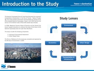
Study Lenses
In 2008, Waterfront Toronto’s Board of Directors and the Toronto City
Council passed resolutions to comence the study of the future of the
Gardiner Expressway East and Lake Shore Boulevard.
Environment
The study includes the following components:
• Individual Environmental Assessment
• Urban Design Study
The Terms of Reference for the study was completed and approved by
the Ministry of Environment in 2009.
Urban Design
Economics
Transportation &
Infrastructure
2. Study Area
Futureof theGardinerEast
Environmental Assessment & Urban Design Study
La
Harbourfront
Centre
Jarvis Street
Church Street
Toronto Inner Harbour
Leslie Street
Spadina Avenue
Yonge Street
Lower Younge
Precinct
East Bayfront
Precinct
way
Gardiner Expressway
Sho
ke
Blvd
re
West Don
Lands Precinct
ark
CN Tower
King Street
yP
Union Station
le
Val
Central Busines
District
Don
Queen Street
Logan Avenue
The section of the Gardiner Expressway East / Lake Shore Boulevard that is being studied for reconfiguration extends from approximately west of
Lower Jarvis Street to approximately Leslie Street. It includes areas south of King Street to the waterfront.
ating
h Ke
Nort
cinct
Pre
Lower Don Lands
e
Lak
hore
S
Port Lands
B
vard
oule
3. Historical Context
The F.G. Gardiner Expressway (Gardiner) was named
after the first chair of the former Metro Council,
Frederick G. Gardiner who was a strong advocate for
the project.
1929: View of Toronto’s Waterfront
Futureof theGardinerEast
Environmental Assessment & Urban Design Study
Construction on the Gardiner began in 1956. It was built in
segments and completed in 1965 at a cost of approximately
$103 million.
1956: Building of the Gardiner Expressway, routed through
industrial waterfront, completed in 1965
The Gardiner runs for about 20 kilometres from the foot of
Highway 427 and the Queen Elizabeth Way in the west to
the Don Valley Parkway in the east.
2000: Demolition of the Gardiner East from Don Valley Parkway to
Leslie Street
1987
1990
1996
2001
2003 - 2006
2008
Study of potential
modifications to the
Gardiner Expressway
ramps in the downtown
area, titled the Central
Bayfront Ramp Study.
The study recommended
several modifications to
the Gardiner Expressway
ramps.
The Crombie
Commission suggested
the removal of the
entire elevated Gardiner
Expressway and its
replacement with a
network of tunnels and
surface roads.
Planning began for the
removal of the 1.3 km
section of the Gardiner
Expressway east of the
Don River, between
Bouchette Street and
Leslie Street, which was
completed in 2003.
The Toronto Waterfront
Revitalization Task Force
proposed that the rest of
the elevated Gardiner
Expressway be replaced.
Recommendations included
a tunnel, improved road
network, construction of
the Front Street Extension,
widening of the Richmond /
Adelaide DVP ramps.
Waterfront Toronto examined
options for the reconfiguration
of the Gardiner / Lake Shore
to stimulate waterfront
revitalization. Studies
demonstrated the cost of
removing the entire Gardiner
was too high. Other scenarios
demonstrated a lower cost;
including the least congested
portion of the expressway from
Lower Jarvis Street to the DVP.
Waterfront Toronto Board of
Directors and City Council
adopted the proposal to
complete an Individual
Environmental Assessment and
Integrated Urban Design study
to explore the feasibility of
removing part of the elevated
Gardiner Expressway from
approximately Jarvis Street to
Logan Avenue.
4. Waterfront Revitalization
Waterfront Toronto’s mandate is to put Toronto at the forefront of
global cities in the 21st century by transforming the waterfront
into beautiful and sustainable communities, fostering economic
growth in knowledge-based, creative industries, and ultimately
redefining how Toronto, Ontario and Canada are perceived by
the world.
A core part of that mission includes building high-quality public
infrastructure, including parks, promenades, boulevards, and
other amenities needed to generate vibrant urban activity.
Corus Quay, East Bay Front
West Don Lands
Spadina WaveDeck, completed 2008
5. This 55
acre site is located on the
Inner Harbour and is within
walking distance of downtown
Toronto. It includes established
neighbourhoods and many
entertainment and cultural
attractions.
The new district will have
7,000 residential units, jobs
for 8,000 people and 1.5
km of continuous water’s
edge promenade.
Quay:
Queens Quay
East Bayfront
A AVE.
JARVIS ST.
YONGE ST.
Expected
to be completed in Spring
2015, the Queens Quay area
will be transformed into an
iconic boulevard where the
needs of all users will be
accommodated.
From recreational and transit,
to bicycle, pedestrian and
vehicular traffic, the overall
landscape and public realm
will be enhanced within the
Queens Quay corridor.
SPADIN
Queens
East Bayfront:
6. Futureof theGardinerEast
Environmental Assessment & Urban Design Study
Don Mouth Naturalization:
Naturalizing
the mouth of the Don River and providing
flood protection to the Port Lands were
identified as one of the top priorities for all three
levels of government when they first announced the
establishment of Waterfront Toronto in 2001. This
project proposes to transform the existing mouth
of the Don River including the Keating Channel,
into a healthier, more naturalized river outlet to the
lake, while at the same time, removing the risk of
flooding to 230 hectares of urban land to the east
and south of the river.
West Don Lands: The West Don Lands’ 80
acre site is immediately adjacent to the Distillery
District and has strong connections to the St.
Lawrence and Corktown neighbourhoods.
Once completed, it will have 5,800 residential
units, including 1,200 units of affordable rental
housing, 1,000,000 square feet of commercial
space, 23 acres of parks and public spaces,
a new transit line, an elementary school, a
recreation centre, and childcare centres.
West Don Lands
Lower Don Lands
Keating Channel (Lower Don Lands): A
Municipal Class EA and Precinct Plan is
being undertaken for the Lower Don
Lands area. This initiative incorporates
approximately 25,000 residents in 12,000
units, mixed use and varied densities.
10,000 jobs are also planned. The Keating
Channel precinct will be the first developed
community of the Lower Don Lands and will
draw the City around the northeast corner of
the Toronto Inner Harbour.
7. Study Goals and Principles
GOAL 1:
REVITALIZE THE WATERFRONT
A public realm that provides adequate
access to open space, landscape, light and
air, and contributes to the revitalization of
the waterfront needs to be created. The
project should:
Prioritize urban design excellence, placemaking, and quality of life as integral
components of project design and
evaluation.
Contribute to the creation of the waterfront
as a regional / tourist destination.
Rejuvenate the underutilized and
derelict lands under and adjacent to the
expressway.
Balance provision of new amenities for
both local and regional users, recognizing
that local and regional stakeholders may
value amenities and infrastructure in
different ways.
Build on existing planning initiatives and
conclusions. The EA study will coordinate
and seek opportunities of mutual benefit
with those initiatives.
Acknowledge this project as an
opportunity for City-building. Evaluate
city-building investments, outcomes,
and benefits in local, regional, and global
contexts.
GOAL 2:
Futureof theGardinerEast
Environmental Assessment & Urban Design Study
RECONNECT THE CITY WITH THE LAKE
The Gardiner Expressway East and Lake
Shore Boulevard pair have long been
perceived as a barrier that disconnects
the downtown from its waterfront. The
railroad viaduct is a physical barrier,
limiting waterfront area access to four
underpasses. Any reconfiguration of the
Gardiner East and Lake Shore Blvd will
need to include welcoming and accessible
routes to the waterfront, breaking down
the psychological and physical barriers
that exist today. The project should:
Create physical, visual, and cognitive
connections to the waterfront for
downtown, the City, and region. The
waterfront is an amenity that belongs
and should be accessible to the
public.
Design the public realm to be attractive,
accessible and connected. The qualities
of experience offered by streets,
plazas, parks, promenades, pathways,
bicycle routes, and visual corridors
will be major drivers of design
decisions. Public spaces should be
accessible and perceived as public.
The new urban fabric should become a
connector between the downtown and
new waterfront communities, one that
uses transit, street design and new
mixed-use communities to stitch the
city with its unique waterfront
experience.
8. Study Goals and Principles
GOAL 3:
BALANCE MODES OF TRAVEL
Any new configuration of the Gardiner Expressway
East and Lake Shore Blvd will need to maintain an
effective local and regional transportation system,
including commuters and freight, and minimize
negative impacts by balancing alternative travel
modes, including transit (local and regional),
cycling and walking within the system. The project
should:
Acknowledge transportation initiatives – both
positive and negative – on regional economic
competitiveness,
land-use,
development
character,
settlement
patterns,
and
environmental issues such as air quality and
ambient noise.
Maintain reliable access to the City and its
neighborhoods for local residents, commuters,
freight trucks, and regional travelers.
The corridor plays an important role in the
movement of traffic through the City and larger
region. The reconfiguration alternatives will
address the through-traffic function of the
Gardiner Expressway East and Lake Shore Blvd.
Acknowledge and integrate other planned transit
(local and regional) initiatives being proposed
for the City.
Consider a combination of supply, system
and
demand
management
measures.
Creatively maximize the performance of
infrastructure through management and
operation.
GOAL 4:
Futureof theGardinerEast
Environmental Assessment & Urban Design Study
ACHIEVE SUSTAINABILITY
This project should advance the City’s and
Waterfront Toronto’s commitment to green,
healthy, and energy efficient development.
Sustainable design solutions can improve
environmental quality and biodiversity, and
minimize public health risks. The project will:
Consider Waterfront Toronto’s and the City’s
sustainability policies and frameworks.
Help contribute to development that has an
overall positive impact. These benefits are
to result in environmental enhancements,
economic security, and social/cultural gains.
Contribute
to
the
improvement
of
environmental quality and public health,
including air quality.
Complement if not enhance other waterfront
environmental naturalization initiatives.
Accommodate the plans for flood conveyance
and flood protection to lands in the Don
River mouth area, the Port Lands and south
Riverdale community.
Promote social engagement and interaction.
Promote the City’s initiatives to reduce
greenhouse gas emissions.
Promote public awareness and education on
environmental issues through the physical
design of infrastructure and public realm.
Integrate ecology and natural systems with
urbanism.
9. Study Goals and Principles
GOAL 5:
CREATE VALUE
The future reconfiguration of the Gardiner Expressway East and
Lake Shore Boulevard can act as a catalyst for good development
and contribute to an integrated, vibrant, and successful
waterfront. Further, any changes to the Gardiner Expressway
East and Lake Shore Blvd pair will require a significant public
investment, whether in rehabilitation and enhancement of the
existing structure or replacement with a new or alternative facility.
That investment should be targeted to maximize opportunities
for revitalization, and to leverage the economic benefits of the
project, rather than simply preserving the single purpose Gardiner
Expressway. The project should:.
Plan and design for positive net value creation in local, regional,
and global contexts.
Define a public and private investment structure that creates
and captures value for the public sector. The public sector,
through these city-building initiatives, creates value for the
community, in terms of streets, open space, and catalysts for
private development.
Maximize net economic and environmental benefits.
Futureof theGardinerEast
Environmental Assessment & Urban Design Study
10. ORIGIN / DESTINATION STUDY – DOWNTOWN VS. THROUGH TRIPS
AM Peak Hour EASTBOUND
Spadina/YorkBay-Yonge
3,000
54%
Eastbound
@ Dufferin
5,650
per hour
5,650
Primary function is not as a regional connection:
Jarvis/
Sherbourne
1,400
25%
2,600
DVP
900
16%
1,200
Gardiner East
Study Area
Spadina/YorkBay-Yonge
2,600
35%
To
Dufferin
/Hwy 427
5,650
21%
1,500
Richmond
1,800
24%
Jarvis/ Sherbourne
500
7%
Lake Shore
350
6%
DVP
4,500 per hour
2,700
AM Peak Hour WESTBOUND
•
4,500
Gardiner East
Study Area
Lake Shore
2,900
Most eastbound Gardiner trips are destined for
downtown locations. Only 22% of eastbound trips
use the Gardiner to bypass the city
•
Most westbound and southbound (from DVP)
Gardiner trips are destined for downtown locations.
Only 21% of westbound and southbound trips use
the Gardiner to bypass the city.
11. How Commuters get Downtown
(AM Peak Hour 2011)
Gardiner East Passes Through Five Emerging
Neighbourhoods
Walk/Cycle
4%
(5,900)
Auto (Gardiner
Eastbound @
Bathurst)
4%
(6,100)
Don River
GO Transit
19%
(29,500)
Bathurst
TTC Transit
49%
(77,700)
Auto (All Other
Routes)
21%
(33,500)
Dupont
4.2km – Lake Shore Blvd East (Yonge to Leslie)
•
Most eastbound Gardiner trips are destined for
e.g. locations. Only Jarvis
downtown Ossington to22% of eastbound trips
use the Gardiner to bypass the city
South Riverdale
2.4km
Auto (Gardiner
Westbound @
DVP)
3%
(5,200)
157,200 Total
2.4km – Gardiner Expressway Elevated Structure
e.g. King to Bloor
Lower
Yonge
East Bayfront
Keating
Port Lands
Source: AM Peak Hour Inbound to Downtown: Transportation City Cordon Count (2011)
Downtown: Defined as Bathurst to Don River and Waterfront to the rail corridor north of Bloor
Transportation Demand Growth
Downtown Population & Employment Growth
250,000
+237,900 Total
Total Trips
200,000
+157,200 Total
150,000
100,000
+115,500 Total
Actual
Projection
50,000
Populatoin/ Employment
AM Peak Hour Inbound to Downtown
600,000
500,000
400,000
300,000
200,000
100,000
0
0
1975 1981 1985 1991 1995 2001 2006 2011 2016 2021 2026 2031
Auto (Gardiner Westbound @ DVP)
Auto (Gardiner Eastbound @ Bathurst)
Auto (All Other Routes)
TTC Transit
GO Transit
Walk/ Cycle
Source: AM Peak Hour Inbound to Downtown: 1) Transportation City Cordon Count (1975-2011); 2) Transportation Model EMME2 Forecast (2011-2031); 3) 2006 Transportation Tomorrow Survey (TTS) for Walk/Cycle Mode and Other Data;
Downtown: Defined as Bathurst to Don River and Waterfront to the rail corridor north of Bloor
Population
Employment
Source: Downtown Employment/ Population: 1) Census Canada (1981-2011); and 2) Employment/ Population City's Flash Forward Report (2011-2031).
Downtown: Defined as Bathurst to Don River and Waterfront to the rail corridor north of Bloor
12. CONSULTATION ACTIVITIES
Consultation for the Gardiner East EA has included
the following activities:
•
stakeholder advisory committee meetings;
•
public forums;
•
web-enabled consultations; and
•
social media.
To date we have successfully engaged over
5,000 individuals.
ROUND ONE CONSULTATION
ROUND TWO CONSULTATION
Round One of the public consultation process was held
between May 28th and June 28th, 2013, and
successfully engaged over 1,000 individuals.
Round Two of the public consultation process occurred
between October 1st and October 31st, 2013, and
successfully engaged over 1,500 individuals.
The purpose of Round One of the consultation process
was to:
•
Reintroduce the EA and Study process and
provide a refresher on the approved EA Terms of
Reference;
•
Identify any changes to the Study since the
approved 2010 Terms of Reference (i.e. Study
Area extents);
•
Obtain feedback from participants to inform the
development of alternative solutions; and
•
Share information on case studies and
innovative options.
The purpose of Round Two of the consultation process
was to:
•
Present the Four Draft Alternative Solutions for
consideration: Maintain, Improve, Replace,
Remove;
•
Identify the Evaluation Process and
opportunities for input;
•
Obtain feedback from participants to refine the
alternative solutions and complete the
evaluation.
Round One consultation focused on 14 “key ideas” for
reconfiguring the Gardiner and Lake Shore Boulevard
that were categorized according to the four
alternatives – Maintain, Improve, Replace and
Remove.
NEXT STEPS
Documentation of the input received during the first
two rounds of consultation is available on the project
website: www.gardinereast.ca
3
13. Maintain the elevated expressway
No Changes to the Previous
Plan
BEFORE
• Move ahead with the Gardiner
rehabilitation program
• Reconstruct deck of
expressway
• Realign Lake Shore Blvd
through the Keating Precinct
(east of Cherry Street, south of
the rail corridor)
AFTER
Improve the urban fabric while maintaining the existing expressway
Previous Plan
• Relocate and rebuild Lake
Shore Blvd under the Gardiner
• Rebuild Gardiner deck with 4
lanes; open in the middle
Revised Plan
• Rebuild Gardiner deck with 4
lanes open on the south side
• Lake Shore largely stays as is
with:
• Intersection improvements
• Remove southern
eastbound lane east of
Jarvis Street
• New east-west walking and
cycling trail
BEFORE
AFTER
Replace with a new expressway
No Changes to the Previous
Plan
• New elevated 4-lane
expressway – ending at Don
River
• Single column design, 5m
higher
• 4 lane Lake Shore Boulevard
• Opens up land for public realm,
parks, green space and
increased development
• Opens up more light and air at
street level
• New east-west walking and
cycling trail
BEFORE
AFTER
Remove the elevated expressway and build a new boulevard
Revised Plan with a
Two Sided Street
• Improved cross section to allow
for an 8 lane boulevard with
development along 85% of the
north and south sides of the
street
• North side development
provides a buffer from rail
corridor
• Opens up entire ground level to
light and air
• Extensively treed boulevard
• New east-west walking and
cycling trail
BEFORE
AFTER
14. Maintain
the elevated expressway
LAKE SHORE BOULEVARD @ SHERBOURNE STREET
•
Gardiner rehab program maintains existing auto capacity
•
No public realm improvements on Lake Shore Boulevard
•
Numerous turn restrictions / conflict points on Lake Shore Boulevard
•
6 years of lane closures on the Gardiner Expressway
•
$300M Cost (NPV), $870M Cost (2013$)
15. Improve
the urban fabric while maintaining the existing expressway
LAKE SHORE BOULEVARD @ SHERBOURNE STREET
•
Modified Gardiner rehab program with reduced lanes and standard shoulders
•
Public realm improvements on Lake Shore Boulevard and new cycling trail
•
Reduction of turn restrictions and conflicts between autos, pedestrians and cyclists
•
6 years of lane closures on the Gardiner Expressway and Lake Shore Boulevard
•
$360M Cost (NPV), $865M Cost (2013$)
16. Replace
with a new expressway
LAKE SHORE BOULEVARD @ SHERBOURNE STREET
•
New elevated structure built to today’s highway standards
•
Public realm improvements on Lake Shore Boulevard and new cycling trail
•
Requires full closure of the corridor for construction
•
$700M Cost (NPV), $1,390M Cost (2013$)
•
$65-70M Revenue (NPV), $150-160M (2013$)
17. Remove
the elevated expressway and build a new boulevard
LAKE SHORE BOULEVARD @ SHERBOURNE STREET
•
•
•
•
•
New 8 lane boulevard – greatest impact to auto travel times
Boulevard lined with 1,200 new trees, dedicated turning lanes, sidewalks, retail frontage and
cycling trail
3 years of lane closures in the expressway corridor
$240M Cost (NPV), $470M Cost (2013$)
$80-90M Revenue (NPV), $220-240M (2013$)
21. Study Lenses
Criteria Group
Planning
Urban Design
Public Realm
Built Form
Regional Economics
Economics
Local Economics
Direct Cost & Benefit
Automobiles
Transit
Pedestrians
Transportation &
Infrastructure
Cycling
Movement of Goods
Safety
Constructability
Social & Health
Natural Environment
Environment
Cultural Resources
Criteria
Consistency with Official Plans
Consistency with Precinct Plans
Streetscape
View Corridors
Public Realm Space (open space, landscape, multi-use paths, plazas, etc.)
Rail Corridor and Berm
Street Frontage
City Competitiveness
Congestion
Business Activity
Visitor/Tourism Attractiveness
On Street Parking
Capital Funding & Cost
Lifecycle Cost
Land Value Creation
Commuter Travel Time
Impact on Average Auto Travel Time within Downtown
Vehicle Volumes/Speed
Road Network Flexibility/Choice
Transit Impact
North-South Sidewalks (crossing times)
East-West sidewalks
East-West Movement
Vehicle Operations
Access Opportunity
Safety Risk for Pedestrians
Safety Risk for Pedestrians and Cyclist
Safety Risk for Cyclists and Motorists
Safety Risks for Motorists on the Gardiner
Duration
Transportation Management
Construction Impact on Private Property
Health (Noise and Air Quality including Greenhouse Gas Emissions)
Terrestrial Environment
Aquatic Environment
Water Quality (stormwater management)
Water Quantity (surface water run-off)
Microclimate
Tree-Lined Shaded Street
Built Heritage
12
Cultural Landscapes
Archaeology
22. Buffalo Skyway, Buffalo
Maintain E. River Waterfront Esplanade, New York Improve
Age of
Infrastructure
Age of
Infrastructure
Decision Made
Decision
Made
Project Cost
Key Impacts
Tourism and city
building, new
access, new
community and
creation of jobs
$117 million (USD)
Rehabilitation for a
safe and reliable
travel route
$165 million
(USD)
Key Impacts
Maintain
(rehabilitate)
existing highway
Improve street
section and
reconfigure
space under
elevated
highway
Project Cost
60 years
59 years
Central Artery / “Big Dig”, Boston
Age of
Infrastructure
45 years
Decision Made
Replace with cutand-cover tunnel
with at-grade
boulevard with
greenway placed
over tunnel
Project Cost
Key Impacts
Embarcadero Freeway, San Francisco
Age of
Infrastructure
32 years
Decision Made
Remove highway
and provide 6-lane
at grade urban
boulevard
Project Cost
$80 million (USD)
Key Impacts
Increased property
values, increase in
jobs, increase in
housing units and
new public space
$22 billion (USD)
Improved travel
times, costly,
increased tourism
and increased
property values
Replace
Remove
23. Contact Us
Participate in Online Discussions
The Gardiner East consultation website provides information as well as hosting
public discussion forums where you can read, rate, post and reply to public
comments on the project.
Visit our website today:
www.GardinerEast.ca
Futureof theGardinerEast
Environmental Assessment & Urban Design Study
CONTACT US
Facilitator’s Office
505 Consumers Road, Suite 1005,
Toronto, Ontario, M2J 4V8
Phone: 416-479-0662
Call, Email or Send Us a Letter
The project team will respond to concerns and requests for information through
the telephone hotline, email, fax, or post. See contact information to the right.
Email: info@gardinereast.ca
Website: www.GardinerEast.ca