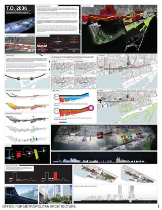
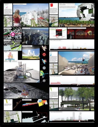
1. 1OFFICE FOR METROPOLITAN ARCHITECTURE
ST. LAWRENCE HALL
DAVID CROMBIE PARK
MILL STREET BREWERY
DISTILLERY DISTRICT
YOUNG CENTER FOR THE
PERFORMING ARTS
ST. LAWRENCE CENTER
FOR THE ARTS
SONY PERFORMING
ARTS CENTER
DOMINION
PUBLIC
COMMERCE
COURT
HOCKEY
HALL OF
FAME
ST. LAWRENCE
NORTH MARKET
ST. LAWRENCE
MARKET
CANADA’S
SUGAR BEACH
(FUTURE)
DON RIVER
PARK / PAN
AM GAMES
(FUTURE)
WETLANDS
(FUTURE)
SHERBOURNE
PARK
(FUTURE)
BAY ADELAIDE
CENTRE
CITY OF
TORONTO
ARCHIVES
CHURCH OF THE
HOLY TRINITY
OLD CITY HALL
CANADIAN OPERA
COMPANY
ROY THOMPSON HALL
UNION STATION
AIR CANADA CENTER
TORONTO
ISLAND
FERRY
REDPATH SUGAR
MUSEUM
DUNDAS SQUARE
ST. MICHAEL’S
HOSPITAL
CITY HALL
T.O. 2036Innovative Design Options for the Gardiner
Expressway and Lake Shore Boulevard
Reconfiguration Environmental Assessment
Toronto’s quality of life and economic development, even post crisis, have kept pace with or out-
stripped its neighbors. Its economic successes are matched by its environmental successes, includ-
ing the extensive green belt surrounding the city.
Like many North American cities, Toronto has grown away from its urban center and waterfront. A
dense core and suburban periphery form a collection of nodes linked through a road network and to
a lesser degree by subway and commuter rail. Despite its competitive mix of auto and public trans-
port, Toronto suffers from the worst commute times in North America. At the junction of the down-
town, the periphery and the waterfront, the areas to the east and west of downtown are missing
links within the city’s network.
Could the key to unlocking the potential of Toronto’s waterfront be to create a new, more potent link
between the core and the periphery? Can reducing the Gardiner’s footprint simultaneously remove
an impediment to the development of its surroundings and INCREASE downtown’s connection its
periphery?
Removing the Gardiner as an obstacle is an important first step towards reorienting Toronto’s
growth, but only a first step...Of the available options to lessen the Gardiner’s impact, removing the
upper deck offers both the best integration of the New Gardiner with its surroundings and the great-
est number of opportunities for navigating across it. The resulting reduction in road capacity—a
reduction that will exacerbate an already congested road network—begs the question of what can
step in to fill the void.
Understanding Toronto Site Potential
GARDINER EXPRESSWAY
LAKESHORE
BOULEVARD
5760 per hour
TOTAL CAPACITY
(12 Lanes)
3600 per hour
CAPACITY
(8 Lanes)
Streecar
Subway
Train
GARDINER EXPRESSWAY
LAKESHORE
BOULEVARD
5760 per hour
TOTAL CAPACITY
(12 Lanes)
3600 per hour
CAPACITY
(8 Lanes)
2160 per hour
CAPACITY
?
Removing the Gardiner How to fill the void?
Reimagining the Gardiner creates opportunities for new north-south connections between the neigh-
borhoods north of the highway and the waterfront, but these connections, while necessary, will not be
sufficient to support the growth of the area surrounding the Gardiner. Our proposal looks not only at
crossing the Gardiner, but at the potential new transit modes along it.
By harnessing the potential of new east-west links between downtown and the rest of Toronto, and
providing a new intermodal link between them (the transferium), it unlocks the untapped promise of
Toronto’s waterfront not only as an environmental amenity but as a new ground for Toronto’s future
growth in an age that has learned the limits of growth through sprawl.
Our proposal uses the opportunity of the Gardiner’s alteration to imagine a new “smart growth” strat-
egy for the city. This strategy offers the city a new dynamic between the old and new, development
and the environment, focusing development adjacent to the city’s core.
Smart Growth
BATHHURSTSTREET
BATHHURSTSTREET
BATHHURSTSTREET
SPADINAAVENUE
JOHNSTREET/REESSTREET
UNIVERSITYAVE/YORKSTREET
BAYSTREET
YONGESTREET
JARVISSTREET
SHERBOURNESTREET
PARLIAMENTSTREET
CHERRYSTREET
DONPARKWAY
CARLAWAVENUE
LESLIESTREET
DONVALLEY
GARDINER EXPRESSWAY
North-South Connections
East-West Connections
T T
T
T
UNION STATION
LAKESHORE BLVD
GARDINER
DONRIVERPARKWAY
STOUFFVILLELINE
LAKESHOREEASTLINE
RICHMONDLINE
Connection
Districts
ELEVATED GARDINER EXPRESSWAY
RAILWAY
RAILWAY
WATERFRONT
WATERFRONT
+ -
VALUE
$$$ $
SUBWAY
TDOWNTOWN
T
DOWNTOWN
TRANSFERIUM
Land Value
BEFORE: The elevated Gardiner suppressed land values
around it...
AFTER: The new multi-nodal transit corridor acts as an attractor
for new development.
HERITAGE MARKET
LAKE-
SHORE BLVD/
METRO
PARK STRIP
ARTS DISTRICT
TRANSFERIUM
ICT BAR
CONFERENCE
GATE
Districts
LAKESHORE BLVD
QUEENS QUAY BLVDGARDINER
CHEERYST
CARLAWST
LESLIEST
PARLIAMENTST
SHERBOURNEST
JARVISST
YOUNGEST
DONRIVERPARKWAY
LAKESHORE BLVD
QUEENS QUAY BLVDGARDINER
CHEERYST
CARLAWST
LESLIEST
PARLIAMENTST
SHERBOURNEST
JARVISST
YOUNGEST
DONRIVERPARKWAY
LAKESHORE BLVD
QUEENS QUAY BLVDGARDINER
CHEERYST
CARLAWST
LESLIEST
PARLIAMENTST
SHERBOURNEST
JARVISST
YOUNGEST
DONRIVERPARKWAY
T T
T
T
T
The east end of the site is a crossroads of two highways, the future relief subway
line, commuter rail, etc. By creating a new transit hub at their conjunction, these
various transport modes can be reorganized and amplified.
Street Car Line Bus Route
Subway Road Network
The removal of the Gardiner allows for the development of the
space of land between rail tracks and road structure, creating a
new spine that links elements of the city.
Lakeshore Boulevard
1. Before 2. After
Existing View Potential
0 50 100 200
Section through Lakeshore Boulevard
2. OFFICE FOR METROPOLITAN ARCHITECTURE
T
LAKESHORE BLVD
DONRIVERPARKWAY
STOUFFVILLELINE
LAKESHOREEASTLINE
RICHMONDLINE
Residential
Mix
Leisure
Culture/Education
Commercial
Office
Hotel
Industry
Program Distribution
1
2
Reorganize Infrastructue
The park strip connects the
David Crombie parks which
run East West along Front
St, to the proposed Sher-
bourne Park. A fragment of
the Gardiner is kept, provid-
ing an elevated pedestrian
platform.
The Heritage Market, links two
the St. Lawrence market and
the Redpath Sugar Factory
located on the waterfront still
operates, period in Toronto’s
history. A series of outdoor
markets, organic in their growth
provide a continuous link be-
tween the two buildings.
ICAE
SILO PARK AND
SLIPHEAD
VICTORY SOYA
MILLS SILO
DAVID CROMBIE PARK
TRINITY STREET
BRIDGE
CHERRY STREET
BRIDGE
DON RIVER PARK
EXISTING
DISTILLERY
The transferium clarifies the cur-
rent infrastructure network, facili-
tating the removal of the Gardiner
by increasing modal use, provid-
ing connections to Subway, GO
Trains (Richmond, Stouffville and
Lakeshore East lines), Street car
(along Queens Quay Boulevard)
aswell as regular bus.
View from the Transferium
P
Don River Valley
Below the Transferium
Transportation Hub View from CN Tower
mum tower height of 120m. In order to encourage a mix development, the tower has
been developed specifically to accomodate office, residential.
Historically, the Distillery District
stands in the location of the first
settlements of Toronto. A complex
of different Distillers, during the
1860’s it was one of the largest
Whiskey distillerys in the world.
Now the area has been converted
into an arts district. With a mix of
cultural arts, galleries and
Transferium
The ICA&E museum located on the Waterfront, provides a clear counter-
point to the Distillery District in the North of the zone. Access to these two
destinations creates a series of clearly defined routes through the site.
ICA&E - Institute of Contemporary Arts and
The Environment
Gathering Space Embedded within the Railway Berm
Section through the Arts District
Connective Trajectories
0 50 100 200
0 50 100 200
Creative city provides a link between
the downtown creative city and the
waterfront, while encouraging inno-
vation in Toronto.
Parking
Ground
Subway
F7
F8
Tower
TRAIN CONNECTION
TRAMWAY
TRAIN
CONVENTION
CENTER
GYM
TOBUSINESSCENTER
TO PAN AM STATION
VISITOR
FACILITIES
CONCOURSE
WATER
PARK&FER
RY
CONVENTION
CENTER
CONVENTION
CENTER
CONVENTION
CENTER
CONVENTION
CENTER
RETAIL
UP
DOW
N
DOWN
UP
OFFICE
SKY LOBBY
CONFERENCE
RETAIL
PARKINGPARKING
CONCOURSECONCOURSE
RETAIL
HOTEL
SUBWAY
GO
TRAIN
STREET
CAR
OFFICE
Program
0 50 100 2000 50 100 2000 50 100 200
Section through Sherbourne Park
Section through Heritage Park
3. 3OFFICE FOR METROPOLITAN ARCHITECTURE
Waterfront Area
Grid Layout
Transportation
Green
Program Distribution
Proposed Buildings
TRANSPORTATION INFRASTRUCTURE
GRID LAYOUT
WATERFRONT AREA
GREEN INFRASTRUCTURE
PROGRAM DISTRIBUTION
BUILDINGS PROPOSED
T
T
T
T
0 50 100 200
The Gardiner has long been acknowledged as a barrier between Toronto and its waterfront, sequestering the city from one of its key ecological assets
and limiting development along its path. Removing the upper deck of the Gardiner offers both the best integration of the roadway with its surroundings
and the greatest number of opportunities for navigating across it.
Reimagining the Gardiner as a grade-level boulevard—Lakeshore Boulevard—we have elaborated several key connections across it. Each of these
navigates the new Lakeshore Boulevard in a different way, passing over, under or across it to create links between key cultural and urban points and
the waterfront.
These connections, while necessary, will not be sufficient to support the growth of the area. Our proposal looks not only at crossing the Gardiner, but
at potential new transit modes along it. The east end of the site is a crossroads of the highway, the future relief subway line, and the commuter rail. By
creating a new transit hub at their conjunction—a Transferium that combines 6,000 parking spaces with stations for various modes of public transit—
transportation to and from downtown can be reorganized and amplified, unlocking the untapped promise of Toronto’s waterfront as not only an environ-
mental amenity but as a new ground for Toronto’s future growth.
In an age that has learned the limits of growth through sprawl, our proposal uses the opportunity of the Gardiner’s alteration to imagine a new “smart
growth” strategy for the city. This strategy offers a new dynamic between the past and the future, development and the environment, focusing develop-
ment adjacent to the city’s core and linking it with the city as a whole.
T.O. 2036
5. 5OFFICE FOR METROPOLITAN ARCHITECTURE
SIDEWALK SIDEWALK
4.5 1.5 3.1 1.5 1.5 1.5 1.5 1.5 1.5 1.5 1.5 1.5 1.5 1.5 1.5
BIKE
WAY
BIKE
WAY
SWALE LANE LANE LANE LANE LANE LANE LANE LANE LANE LANE
SUBWAY RIGHT OF WAY
TYPICAL CONDITION
ALONG BOULEVARD
PLATFORMPLATFORM
Section through Lakeshore Boulevard