Importing Survey Data | ACAD Civil 3D | Total Station |
•
6 likes•2,344 views

A report prepared and compiled using AutoCAD Civil 3D 2016. This report contents are Import of survey points or data into the computer, Creating Alignment, Making A Profile of road, and so on. Road Alignment | Road Profile | Contour | Box Culvert | Add Labels | Pick Coordinates | Center Line Coordinates | Surface | Survey | Incremental Station Report |

Recommended
More Related Content
What's hot
What's hot (20)
Similar to Importing Survey Data | ACAD Civil 3D | Total Station |
Similar to Importing Survey Data | ACAD Civil 3D | Total Station | (20)
More from Zakaria Yahya
More from Zakaria Yahya (13)
Recently uploaded
Recently uploaded (20)
Importing Survey Data | ACAD Civil 3D | Total Station |
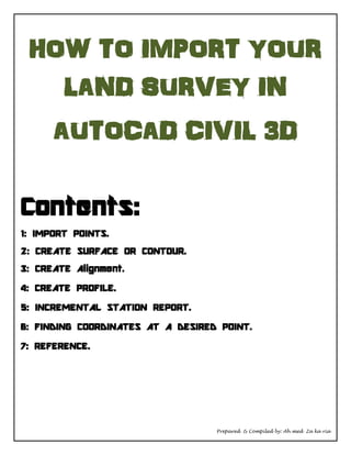
- 1. Prepared & Compiled by: Ah med Za ka ria HOW TO IMPORT YOUR LAND SURVEY IN AUTOCAD CIVIL 3D Contents: 1: IMPORT POINTS. 2: CREATE SURFACE OR CONTOUR. 3: CREATE Alignment. 4: CREATE PROFILE. 5: INCREMENTAL STATION REPORT. 6: FINDING COORDINATES AT A DESIRED POINT. 7: REFERENCE.
- 2. Prepared & Compiled by: Ah med Za ka ria OFFICE WORK AND DATA IMPORT FROM EQUIPMENT TO COMPUTER AND THEN TO AUTOCAD CIVIL 3D 2016. 1: IMPORT POINTS: First import points from total station to PC using USB or data cable. Now you will be requiring software of equipment, we are using LEICA TOTAL STATION. Now open the file which has been imported from Total Station. Using Leica software, now select all points, copy them all and paste it in excel file. When you paste points in the excel file they will be in order of DENZ, whereas we need them in PENZD. Here PENZD stands for: P = Point E = Easting N = Northing Z = Elevation
- 3. Prepared & Compiled by: Ah med Za ka ria D = Description So the file is in DENZ format. Shift the D column to the extreme last right side, and make point no in the first column to make it PENZD format. Set its formation in PENZD. Save file in PENZD comma delaminate format. Open ACAD Import points.
- 4. Prepared & Compiled by: Ah med Za ka ria Add file, with PENZD comma delaminate format Here is the example of series of survey pints, a collection of thousand points for contour and designing purpose.
- 5. Prepared & Compiled by: Ah med Za ka ria 2: CREATE SURFACE OR CONTOUR: To create a contour: Click on Surface, then create surface. Now, you have created a surface in AutoCAD with a desired name head to: Toolspace Click Surfaces Open your created surface file which you have added Go to definition Right click on point files and add the file You have to add the same which we added earlier for points import Steps are shown below in the picture
- 6. Prepared & Compiled by: Ah med Za ka ria The program has created a contour as shown in the picture. Now delete the excess lines by going to contour or surface properties. Highlight the surface, after right clicking go to the surface properties as and proceed as shown in the picture. Set contour and triangles in the surface style.
- 7. Prepared & Compiled by: Ah med Za ka ria Delete all excessive lines. Below pictures showing excessive lines and deleted lines. Open surface properties again and change surface style from triangles to “Contour Design” as shown in picture.
- 8. Prepared & Compiled by: Ah med Za ka ria Here is the Final contour display in Contour Design 1m to 5m. 3: CREATE Alignment. Join all points using Polyline. Green arrow shows all the points, whereas orange arrow shows Polyline. Now make it Alignment Open Alignment tab from task bar. After clicking on any of the first two options, select the polyline, it will ask for direction, tap enter, twice. On this window click ok, as shown in picture below.
- 9. Prepared & Compiled by: Ah med Za ka ria Here comes the alignment 4: CREATE PROFILE. Save Station and Elevation from excel in a Text tab (to notepad)
- 10. Prepared & Compiled by: Ah med Za ka ria Here is the notepad file Now for profile first load file, Open file and name it, then save it It will be loaded on the program. Now Create profile from surface (surface file has been uploaded already). Click on draw in profile view
- 11. Prepared & Compiled by: Ah med Za ka ria Here comes the profile as shown in pic below Now setting it up using bands. Right click on profile then select properties and goto bands. Now for setting bands there are three things, NGL,DG and Stations where DG= Design Grade . NGL= Natural Ground Level.
- 12. Prepared & Compiled by: Ah med Za ka ria Add three files from already presented files for DG,NGL and Stations Again goto, then bands
- 13. Prepared & Compiled by: Ah med Za ka ria Then change format for DG (Design Grade), from surface to layout Now, Click on the drop down corner left menu and click on tangent with curves. Now draw your own profile by balancing cut and fill. Here it is showing DG, NGL, Stations.
- 14. Prepared & Compiled by: Ah med Za ka ria 5: INCREMENTAL STATION REPORT. For marking of center line on site you will need coordinates of Alignment for every 12.5M, 20M or 25M as per requirement. Go to tool space and then follow steps below as seen in the pic below. Double tab the 5th step and then select Alignment no for which you need Co-ordinates. Select Alignment for which you need coordinates. Enter station distance in station increment box. Create report and then paste that report in MS EXCEL.
- 15. Prepared & Compiled by: Ah med Za ka ria 6: FINDING COORDINATES AT A DESIRED POINT. For marking purpose you will require coordinates of any plot or obstacles on any location from drawing. Select Alignment which is located close to your desire location. Then go to add labels and select “station offset at fixed point”. Now start picking points using the pointer. To remove extra information, Explode the box and delete all extra information and keep only Easting and Northing. 7: REFERENCE: Data collected and prepared from AutoCAD help. Coordinates used in this file are real and exist.