Downloaded 41 times
![Atmospheric Stability
Hot Air Rises (and Cold Air Falls)
• Rising air expands because of less (atmospheric) pressure.
• The expansion causes the air to cool.
Eventually the parcel of air will stabilize.
Warming from below reduces stability.
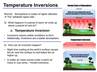
The decrease in temperature as you go up in altitude
is known as the “lapse rate”. (“adiabatic lapse rate”)
Q: Is it colder in town or at the top
of Pikes Peak? -- How much?
The average lapse rate is: 2°C (3.5°F) per 1000 ft.
- Water vapor is lighter than air. → Adding moisture causes a parcel of air to rise.
- Moist air cools at a slower rate than dry air. [science: due to condensation]
- The actual lapse rate is: less in moist air and higher in dry air.
as low as: 1.1°C(2°F) to 3°C(5.4°F)](https://image.slidesharecdn.com/aefco-class6-weathertheory-141206001354-conversion-gate01/85/Weather-Theory-Class-6-AEFCO-2-320.jpg)
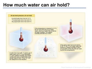
![Humidity
Q: What is Humidity? -- A: Moisture (water) in the air
Relative Humidity is measured between 0% and 100%
Q: What happens at 100% humidity?
A: The air is “full” of moisture Condensation (Clouds, Fog)
The moisture ‘beyond’ 100% humidity can not remain as a gas
(vapor) and condenses out as liquid. Liquid water is visible. It
is know by many names: “steam”, “clouds”, “fog”.
Q: How much water can a cubic foot of air hold?
A: It depends!
1. It depends on the Temperature of the air
(and)
2. It depends on the Pressure of the air. [pressure = Altitude]](https://image.slidesharecdn.com/aefco-class6-weathertheory-141206001354-conversion-gate01/85/Weather-Theory-Class-6-AEFCO-5-320.jpg)

This document discusses various weather theory topics including atmospheric stability, temperature inversions, relative humidity, dew point, and cloud classification. It explains how temperature and moisture levels change with altitude and the conditions required for different cloud types to form. Temperature inversions occur when warm air is above cold air rather than the normal cooling with increasing altitude. Relative humidity is measured as a percentage and condensation occurs at 100% humidity. Dew point indicates the temperature at which the air becomes saturated with moisture. Clouds are grouped into low, middle, and high altitude categories based on their composition and heights.


![18.2[1] cloud formation](https://cdn.slidesharecdn.com/ss_thumbnails/18-21cloudformation-100415125441-phpapp01-thumbnail.jpg?width=640&height=640&fit=bounds)


