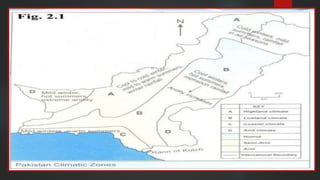
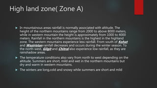
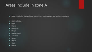
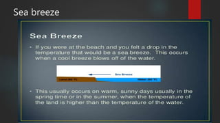
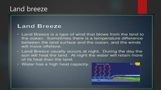
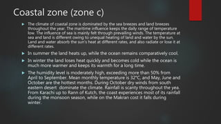
Weather & Climate
TEAM MEMBERS: MUHAMMAD HUSNAIN, TAHA KAMAL, MAHNOOR
JANJUA, ZEESHAM, ZURDAT BATOOL
Topics to be discussed:
 What is weather?
 What is Climate?
 What are climatic zones? (In Pakistan)
 What are highland zones and their climate?
 What are lowland zones and their climate?
 What are arid zones and their climate?
 What are coastal zones and their climate?
 What is river flood and what destruction can it possibly cause?
 What are storms and there causes?
Weather
 Weather refers to atmospheric conditions
(temperature, rainfall, humidity, and pressure) of any
place for a short period of time. It is often localized.
 Example: Weather of Jhelum is sunny today.
 Weather in Jhelum is rainy today.
 Weather in Jhelum is windy today.
Climate
 Climate is a generalization of the day to day weather
conditions over a long period of time, that is usually
30-40 years.
 Example: The climate of Jhelum is really humid.
 Bahawalpur is really dry city.
 Climate of Africa is really dry.
Climatic Zones:
 A country’s climate is divided into different zones
when its topographical area is highly diverse.
 E.g. Pakistan’s topographical area ranges from lofty
mountains to low lying Indus plains and as there
areas with different altitudes , there humidity and
temperature is also different, leading to a different
climate from other areas.
Climatic Zones of Pakistan
 Highland zone
 Lowland zone (semi-arid to arid)
 Arid zone
 Coastal zone
High land zone( Zone A)
 In mountainous areas rainfall is normally associated with altitude. The
height of the northern mountains range from 2000 to above 8000 meters,
while in western mountain the height is approximately from 1000 to 4000
meters. Rainfall in the northern mountains is the highest in the highland
zone. The western mountains experience less rainfall. From south of Kohat
and Waziristan rainfall decreases and occurs during the winter season. To
the north-west, Gilgit and Chitral also experience low rainfall, as they are
rainshadow areas.
 The temperature conditions also vary from north to west depending on the
altitude. Summers are short, mild and wet in the northern mountains but
dry and warm in western mountains.
 The winters are long,cold and snowy while summers are short and mild
Areas include in zone A
 Areas included in highland zone are northern, north-western and western mountains.
 Gilgit Baltistan
 Gilgit
 Skardu
 Ghangche
 Shigar
 Makhan pura
 Asqurdas
 Sumo
 Nagar
 Gupi
 Gultari
Economical and agricultural activities:
 Due to freezing temperatures growth of tress is retarded.
 Due to the climatic properties farming is impossible, due to the train
steepness and due to temperature.
 Transhumance is carried out
 Most of the pathan tribes men are nomadic herders.
 To the south the temperature and the rainfall increases making it possible
to grow fruits including apples, mangoes, apricots and grapes.
 People are involved in indoor activites such as
Lowland zone (Zone B)
 Lowland zone has an arid and extreme climate with hot summers, cool
winters and summer monsoon rainfall. The amount of rainfall differs from
north to south. The foothills of the northern mountains and the potwar
plateau are wetter then the Indus plain, and also receive rainfall from
western dipressions.
 Thunderstorms are also common in the north and north-west of the Indus
Plain. The Southern Upper Indus plain and whole of the lower Indus plain
have much less rainfall and spells of very high temperature.
Areas included in lowland zones:
 This region includes the whole of the indus plain except the coastal areas
 Punjab
 Multan
 Jhelum
 Islamabad
 Sargodha
 Lahore
 Faisalabad
Economical and agricultural activities:
 The fertile plain of Punjab, drained by the Indus and its four
tributaries has a continental or extreme type of climate. It is
because of the northerly position of the Punjab Plain. In the
daytime summers are extremely hot. Wineters are cool to
mild. Economically, the Punjab plain is the most productive
agricultural region of Pakistan. In view of the generally varied
and irregular rainfall; there is a well-developed canal irrigation
system to raise crops like wheat, millet, cotton and sugar-
cane.
Sea breeze
Land breeze
Coastal zone (zone c)
 The climate of coastal zone is dominated by the sea breezes and land breezes
throughout the year. The maritime influence keeps the daily range of temperature
low. The influence of sea is mainly felt through prevailing winds. The temperature at
sea and land is different owing to unequal heating of land and water by the sun.
Land and water absorb the sun’s heat at different rates, and also radiate or lose it at
different rates.
 In summer the land heats up, while the ocean remains comparatively cool.
 In winter the land loses heat quickly and becomes cold while the ocean is
much more warmer and keeps its warmth for a long time.
 The humidity level is moderately high, exceeding more than 50% from
April to September. Mean monthly temperature is 32°C, and May, June and
October are the hottest months. During October dry winds from south
eastern desert dominate the climate. Rainfall is scanty throughout the yea.
From Karachi up to Rann of Kutch, the coast experiences most of its rainfall
during the monsoon season, while on the Makran cost it falls during
winter.
Areas included in coastal zone
 Port of Karachi.
 Gwadar Port.
 Port Qasim.
 Bundal Island.
 Manora.
 Astola Island.
Agricultural and economic activities:
 The main vegetation found around the coastal areas are mangrove forests.
Mangroves provide breeding ground for variety of fish, shrimps, crabs and
other invertebrates and also are of great significance as a source of nutrients
for fisheries. Since majority of the people residing near or around the coastal
areas are engaged in fishing and related activities, mangroves make an
important contribution to the local and national economy.
 The most commonly distributed specie is Avicennia marina (Grey mangrove or
Timar) that comprises 99% of the total vegetation.
 The coastal wetlands attract a number of migratory birds, particularly
waterfowl. Two species of turtles are also found in the shores of the Karachi
coastline. These are the Green Turtle (Cheldnoia mydas) ad Olive Ridley Turtles
(Lapidochely).
Makran Coast
 Makran s a semi-desert coastal strip in Balochistan, in Pakistan and Iran,
along the coast of the Persian Gulf and the Gulf of Oman.
 The narrow coastal plain rises rapidly into several mountain ranges. Of the
1,000 kilometres (620 mi) coastline, around 750 kilometres (470 mi) is in
Pakistan. The climate is dry with little rainfall. Makran is very sparsely
inhabited, with much of the population concentrated in a string of small
ports including Chabahar, Gwatar, Jiwani, Jask, Sirik, Gwadar (not to be
confused with Gwatar), Pasni, Ormara and many smaller fishing villages.
 There is only one island off the coast of Makran, Astola Island, near Pasni
although there are several small islets. The coastline can be divided into an
eastern lagoon coastline and a western embayed coastline. The main
lagoons are Miani Hor and Kalamat Hor. The main bays of the embayed
coast are Gwadar Bay and Gwatar Bay. This latter bay shelters a large
mangrove forest and the nesting grounds of endangered turtle species.
The Mirani Dam provides irrigation, flood prevention and water supply to
Gwadar city.
Arid zone (Zone D)
 An arid climate is markedly dry and hot. Hot dusty winds prevail almost
continuously from mid-May to mid-September. Most of the scanty rainfall
in south-western Balochistan takes place during winter season. In the
south-eastern desert, summer monsoon bring little rainfall. Extreme heat,
dryness and dust storms are the main features of this arid climate.
 A region is arid when it is characterized by a severe lack of available water,
to the extent of hindering or preventing the growth and development of
plant and animal life. Environments subject to arid climates tend to lack
vegetation and are called xeric or desertic.
 The whole of Sindh(except coastal zone) receive only 100 mm of annual
rainfall and the average monthly temperatures are 38°C.
Areas included in Arid zone
 South-western Balochistan
 South-eastern desert
 Kharan desert
 Chagai hills
 Sindh (except coastal zone)
 Extreme southern Punjab desert
Agricultural and Economic activities:
 Region is so hot that the water flowing in exposed irrigation
system cant reach the crops before it is evaporated. To
overcome this problem an underground irrigation system of
karez is built to protect water from evaporating.
 Most crops and fruits are grown in orchards. As they hold
water for much longer than plain irrigation fields.
 Most of the arid zones are famous due to their dry fruit
production and, it is from it that the people earn money.
River Floods:
 Floods are natural events. They mainly happen when the river catchment,
(that is the area of land that feeds water into the river and the streams that
flow into the main river) receives greater than usual amounts of water (for
example through rainfall or melting snow).
Why are river floods caused?
 Floods are natural events. They mainly happen when the river catchment, (that
is the area of land that feeds water into the river and the streams that flow into
the main river) receives greater than usual amounts of water (for example
through rainfall or melting snow). The river cannot cope and this extra water
causes the level of the water in the river to rise and a flood to take place. This
flooding may take place at any point along the river course and not necessarily
at the place where the extra water has entered.
 In 1947 a severe winter blew into Europe from Russia. "When it began to thaw
the River Trent burst its banks and brought floods to Nottingham. Fifty
thousands acres of farmland were engulfed by water with hundreds of homes
cut off from dry land. Two and a half thousand acres of the city were
waterlogged, submerging 28 miles (45 km) of streets."
Ways to reduce flood risk:
 Planting trees on the foothills to check the flow of running water.
 Enlarging the river channel so that it can hold more water.
 Building embankments on either side of the channel to prevent the spread of
floodwater.
 Building extra channels to take floodwater away from the town.
 Building reservoirs on the river to store water and control peak discharge.
 Preventing building in areas where flooding is most likely.
 Publicizing flood warnings through radio, televisions and newspapers.
 Evacuation of flooded areas and providing necessary facilities for rehabilitation.
Benefits of floods:
 Floods return nutrients to barren land which makes it fertile and cultivable.
 Transport of alluvium, that increases land fertility.
 Flooded fields can be used for rice plantation.
 Allowing rivers to overflood with dry and barren land proves to be
beneficial than letting it flood narrow areas downstream.
 Increase in nutrients of delta due to river flooding promotes aquatic life.
 Floods recharge ground water supplies.
Storms:
 Thunderstorms are common in north and north-western areas of Pakistan.
In the summer (April-June) and the post-monsoon season(Sept-Oct), the
atmospheric pressure falls and convectional currents cause sporadic and
localized rainfall in the extreme north and the Safed Koh Mountains. This is
accompanied by strong winds from 60-80 km per hour. Stormy rainfalls
and hail occurs as a result of these winds, which cause the destruction of
apples, pears and other crops grown there.
 In the summer season, in southern plains and north-western parts of
Balochistan, due to low pressure, dust storms and strong winds are also
experienced..
Damage of thunderstorms:
 Sometimes, such dust storms also hit the upper Indus Plain and, like
floods, damage crops and orchards. When the windstorm is high of high
intensity, the roofs of the houses are badly affected and electricity and
communication systems are badly affected.
How to minimize damage from
thunderstorms:
 following tips to prevent damage to property:
 Hail
 “Cover all glass or delicate outdoor items and furniture.
 Close all windows and doors during a hailstorm.
 Install UL 2218 or FM 4473 as Class 3 or 4 shingles, for better protection.
 Put vehicles in the garage during hailstorms or cover with a thick blanket.
 Move flowers and flower pots under cover.
 Water
CONTD
 Inspect home roofs regularly for loose or curled shingles (this also applies for wind).
 Properly grade lot to avoid water seeping back into house.
 Clear gutters and downspouts of debris to ensure proper drainage.
 Ensure downspouts are located and facing away from the house.
 Reduce air and water leaks with weather stripping around doors and windows.
 Locate and seal any cracks in foundation walls and basement floor.
 Wind
 Replace rock and gravel landscaping material with shredded bark.
 Install impact-resistant shutters over large windows and glass doors.
 Secure all moveable outdoor items or relocate them indoors.
 Keep trees and shrubbery trimmed and remove weak trees that may fall.
 Avoid parking vehicles near or below trees, lampposts or power lines.
 Secure all HVAC units, skylights and pipes to avoid being blown away.”
References:
 The Environment of Pakistan (New Edition) (Huma naz sethi)
 INTERNET 
THE END
THANKS FOR YOUR PRECIOUS TIME!!!!!!!!

Weather and climate IG

  • 1.
    Weather & Climate TEAMMEMBERS: MUHAMMAD HUSNAIN, TAHA KAMAL, MAHNOOR JANJUA, ZEESHAM, ZURDAT BATOOL
  • 2.
    Topics to bediscussed:  What is weather?  What is Climate?  What are climatic zones? (In Pakistan)  What are highland zones and their climate?  What are lowland zones and their climate?  What are arid zones and their climate?  What are coastal zones and their climate?  What is river flood and what destruction can it possibly cause?  What are storms and there causes?
  • 3.
    Weather  Weather refersto atmospheric conditions (temperature, rainfall, humidity, and pressure) of any place for a short period of time. It is often localized.  Example: Weather of Jhelum is sunny today.  Weather in Jhelum is rainy today.  Weather in Jhelum is windy today.
  • 4.
    Climate  Climate isa generalization of the day to day weather conditions over a long period of time, that is usually 30-40 years.  Example: The climate of Jhelum is really humid.  Bahawalpur is really dry city.  Climate of Africa is really dry.
  • 5.
    Climatic Zones:  Acountry’s climate is divided into different zones when its topographical area is highly diverse.  E.g. Pakistan’s topographical area ranges from lofty mountains to low lying Indus plains and as there areas with different altitudes , there humidity and temperature is also different, leading to a different climate from other areas.
  • 6.
    Climatic Zones ofPakistan  Highland zone  Lowland zone (semi-arid to arid)  Arid zone  Coastal zone
  • 8.
    High land zone(Zone A)  In mountainous areas rainfall is normally associated with altitude. The height of the northern mountains range from 2000 to above 8000 meters, while in western mountain the height is approximately from 1000 to 4000 meters. Rainfall in the northern mountains is the highest in the highland zone. The western mountains experience less rainfall. From south of Kohat and Waziristan rainfall decreases and occurs during the winter season. To the north-west, Gilgit and Chitral also experience low rainfall, as they are rainshadow areas.  The temperature conditions also vary from north to west depending on the altitude. Summers are short, mild and wet in the northern mountains but dry and warm in western mountains.  The winters are long,cold and snowy while summers are short and mild
  • 9.
    Areas include inzone A  Areas included in highland zone are northern, north-western and western mountains.  Gilgit Baltistan  Gilgit  Skardu  Ghangche  Shigar  Makhan pura  Asqurdas  Sumo  Nagar  Gupi  Gultari
  • 10.
    Economical and agriculturalactivities:  Due to freezing temperatures growth of tress is retarded.  Due to the climatic properties farming is impossible, due to the train steepness and due to temperature.  Transhumance is carried out  Most of the pathan tribes men are nomadic herders.  To the south the temperature and the rainfall increases making it possible to grow fruits including apples, mangoes, apricots and grapes.  People are involved in indoor activites such as
  • 11.
    Lowland zone (ZoneB)  Lowland zone has an arid and extreme climate with hot summers, cool winters and summer monsoon rainfall. The amount of rainfall differs from north to south. The foothills of the northern mountains and the potwar plateau are wetter then the Indus plain, and also receive rainfall from western dipressions.  Thunderstorms are also common in the north and north-west of the Indus Plain. The Southern Upper Indus plain and whole of the lower Indus plain have much less rainfall and spells of very high temperature.
  • 12.
    Areas included inlowland zones:  This region includes the whole of the indus plain except the coastal areas  Punjab  Multan  Jhelum  Islamabad  Sargodha  Lahore  Faisalabad
  • 13.
    Economical and agriculturalactivities:  The fertile plain of Punjab, drained by the Indus and its four tributaries has a continental or extreme type of climate. It is because of the northerly position of the Punjab Plain. In the daytime summers are extremely hot. Wineters are cool to mild. Economically, the Punjab plain is the most productive agricultural region of Pakistan. In view of the generally varied and irregular rainfall; there is a well-developed canal irrigation system to raise crops like wheat, millet, cotton and sugar- cane.
  • 14.
  • 15.
  • 16.
    Coastal zone (zonec)  The climate of coastal zone is dominated by the sea breezes and land breezes throughout the year. The maritime influence keeps the daily range of temperature low. The influence of sea is mainly felt through prevailing winds. The temperature at sea and land is different owing to unequal heating of land and water by the sun. Land and water absorb the sun’s heat at different rates, and also radiate or lose it at different rates.  In summer the land heats up, while the ocean remains comparatively cool.  In winter the land loses heat quickly and becomes cold while the ocean is much more warmer and keeps its warmth for a long time.  The humidity level is moderately high, exceeding more than 50% from April to September. Mean monthly temperature is 32°C, and May, June and October are the hottest months. During October dry winds from south eastern desert dominate the climate. Rainfall is scanty throughout the yea. From Karachi up to Rann of Kutch, the coast experiences most of its rainfall during the monsoon season, while on the Makran cost it falls during winter.
  • 17.
    Areas included incoastal zone  Port of Karachi.  Gwadar Port.  Port Qasim.  Bundal Island.  Manora.  Astola Island.
  • 18.
    Agricultural and economicactivities:  The main vegetation found around the coastal areas are mangrove forests. Mangroves provide breeding ground for variety of fish, shrimps, crabs and other invertebrates and also are of great significance as a source of nutrients for fisheries. Since majority of the people residing near or around the coastal areas are engaged in fishing and related activities, mangroves make an important contribution to the local and national economy.  The most commonly distributed specie is Avicennia marina (Grey mangrove or Timar) that comprises 99% of the total vegetation.  The coastal wetlands attract a number of migratory birds, particularly waterfowl. Two species of turtles are also found in the shores of the Karachi coastline. These are the Green Turtle (Cheldnoia mydas) ad Olive Ridley Turtles (Lapidochely).
  • 19.
    Makran Coast  Makrans a semi-desert coastal strip in Balochistan, in Pakistan and Iran, along the coast of the Persian Gulf and the Gulf of Oman.  The narrow coastal plain rises rapidly into several mountain ranges. Of the 1,000 kilometres (620 mi) coastline, around 750 kilometres (470 mi) is in Pakistan. The climate is dry with little rainfall. Makran is very sparsely inhabited, with much of the population concentrated in a string of small ports including Chabahar, Gwatar, Jiwani, Jask, Sirik, Gwadar (not to be confused with Gwatar), Pasni, Ormara and many smaller fishing villages.  There is only one island off the coast of Makran, Astola Island, near Pasni although there are several small islets. The coastline can be divided into an eastern lagoon coastline and a western embayed coastline. The main lagoons are Miani Hor and Kalamat Hor. The main bays of the embayed coast are Gwadar Bay and Gwatar Bay. This latter bay shelters a large mangrove forest and the nesting grounds of endangered turtle species. The Mirani Dam provides irrigation, flood prevention and water supply to Gwadar city.
  • 20.
    Arid zone (ZoneD)  An arid climate is markedly dry and hot. Hot dusty winds prevail almost continuously from mid-May to mid-September. Most of the scanty rainfall in south-western Balochistan takes place during winter season. In the south-eastern desert, summer monsoon bring little rainfall. Extreme heat, dryness and dust storms are the main features of this arid climate.  A region is arid when it is characterized by a severe lack of available water, to the extent of hindering or preventing the growth and development of plant and animal life. Environments subject to arid climates tend to lack vegetation and are called xeric or desertic.  The whole of Sindh(except coastal zone) receive only 100 mm of annual rainfall and the average monthly temperatures are 38°C.
  • 21.
    Areas included inArid zone  South-western Balochistan  South-eastern desert  Kharan desert  Chagai hills  Sindh (except coastal zone)  Extreme southern Punjab desert
  • 22.
    Agricultural and Economicactivities:  Region is so hot that the water flowing in exposed irrigation system cant reach the crops before it is evaporated. To overcome this problem an underground irrigation system of karez is built to protect water from evaporating.  Most crops and fruits are grown in orchards. As they hold water for much longer than plain irrigation fields.  Most of the arid zones are famous due to their dry fruit production and, it is from it that the people earn money.
  • 23.
    River Floods:  Floodsare natural events. They mainly happen when the river catchment, (that is the area of land that feeds water into the river and the streams that flow into the main river) receives greater than usual amounts of water (for example through rainfall or melting snow).
  • 24.
    Why are riverfloods caused?  Floods are natural events. They mainly happen when the river catchment, (that is the area of land that feeds water into the river and the streams that flow into the main river) receives greater than usual amounts of water (for example through rainfall or melting snow). The river cannot cope and this extra water causes the level of the water in the river to rise and a flood to take place. This flooding may take place at any point along the river course and not necessarily at the place where the extra water has entered.  In 1947 a severe winter blew into Europe from Russia. "When it began to thaw the River Trent burst its banks and brought floods to Nottingham. Fifty thousands acres of farmland were engulfed by water with hundreds of homes cut off from dry land. Two and a half thousand acres of the city were waterlogged, submerging 28 miles (45 km) of streets."
  • 25.
    Ways to reduceflood risk:  Planting trees on the foothills to check the flow of running water.  Enlarging the river channel so that it can hold more water.  Building embankments on either side of the channel to prevent the spread of floodwater.  Building extra channels to take floodwater away from the town.  Building reservoirs on the river to store water and control peak discharge.  Preventing building in areas where flooding is most likely.  Publicizing flood warnings through radio, televisions and newspapers.  Evacuation of flooded areas and providing necessary facilities for rehabilitation.
  • 26.
    Benefits of floods: Floods return nutrients to barren land which makes it fertile and cultivable.  Transport of alluvium, that increases land fertility.  Flooded fields can be used for rice plantation.  Allowing rivers to overflood with dry and barren land proves to be beneficial than letting it flood narrow areas downstream.  Increase in nutrients of delta due to river flooding promotes aquatic life.  Floods recharge ground water supplies.
  • 27.
    Storms:  Thunderstorms arecommon in north and north-western areas of Pakistan. In the summer (April-June) and the post-monsoon season(Sept-Oct), the atmospheric pressure falls and convectional currents cause sporadic and localized rainfall in the extreme north and the Safed Koh Mountains. This is accompanied by strong winds from 60-80 km per hour. Stormy rainfalls and hail occurs as a result of these winds, which cause the destruction of apples, pears and other crops grown there.  In the summer season, in southern plains and north-western parts of Balochistan, due to low pressure, dust storms and strong winds are also experienced..
  • 28.
    Damage of thunderstorms: Sometimes, such dust storms also hit the upper Indus Plain and, like floods, damage crops and orchards. When the windstorm is high of high intensity, the roofs of the houses are badly affected and electricity and communication systems are badly affected.
  • 29.
    How to minimizedamage from thunderstorms:  following tips to prevent damage to property:  Hail  “Cover all glass or delicate outdoor items and furniture.  Close all windows and doors during a hailstorm.  Install UL 2218 or FM 4473 as Class 3 or 4 shingles, for better protection.  Put vehicles in the garage during hailstorms or cover with a thick blanket.  Move flowers and flower pots under cover.  Water
  • 30.
    CONTD  Inspect homeroofs regularly for loose or curled shingles (this also applies for wind).  Properly grade lot to avoid water seeping back into house.  Clear gutters and downspouts of debris to ensure proper drainage.  Ensure downspouts are located and facing away from the house.  Reduce air and water leaks with weather stripping around doors and windows.  Locate and seal any cracks in foundation walls and basement floor.  Wind  Replace rock and gravel landscaping material with shredded bark.  Install impact-resistant shutters over large windows and glass doors.  Secure all moveable outdoor items or relocate them indoors.  Keep trees and shrubbery trimmed and remove weak trees that may fall.  Avoid parking vehicles near or below trees, lampposts or power lines.  Secure all HVAC units, skylights and pipes to avoid being blown away.”
  • 31.
    References:  The Environmentof Pakistan (New Edition) (Huma naz sethi)  INTERNET 
  • 32.
    THE END THANKS FORYOUR PRECIOUS TIME!!!!!!!!