SlideShare a Scribd company logo
Walking routes to school in new urban and suburban neighborhoods: An
environmental walkability analysis of blocks and routes
Jonathan M. Gallimore a,*, Barbara B. Brown a,b
, Carol M. Werner b,c
a
Department of Family & Consumer Studies, 225 S 1400 E RM 228, University of Utah, Salt Lake City, UT 84112-0080, USA
b
Institute for Public and International Affairs, University of Utah, Salt Lake City, UT 84112, USA
c
Department of Psychology, 380 South 1530 East, Room 502, University of Utah, Salt Lake City, UT 84112, USA
a r t i c l e i n f o
Article history:
Available online 13 January 2011
Keywords:
Walkability
Urban design
New urbanism
Environmental perceptions
Walk to school
a b s t r a c t
We assessed environmental and perceptual correlates of walking and walkability for fifth graders from
three communities attending two schools: A new urban/LEED-ND pilot community, mixed, and standard
suburban community. Irvine-Minnesota Inventory (IMI) walkability audits showed that new urban
blocks provided more traffic safety, pleasurability, crime safety, density, and diversity. New urban routes
offered greater traffic safety, accessibility, pleasurability, crime safety, and diversity, but suburban routes
had greater housing density, net of controls (parental education, rooms in the home, home ownership,
parent preference for child to walk to school). Parents and children perceived new urban routes to be
more walkable and children walked more when they lived on more walkable routes. The suburban
hierarchical street design exposed children to varied traffic safety conditions by funneling their walks
from cul-de-sacs to arterials. The new urban routes to a centrally located school passed by pleasant open
spaces, suggesting how community organization can create better walking conditions.
Ó 2011 Elsevier Ltd. All rights reserved.
1. Introduction
Between 1969 and 2001 in the U.S., walking to school decreased
from 40.7% to 12.9% (McDonald, 2007), a dramatic decline of over
two-thirds. Since the 1960s and 1970s, children’s overall levels of
physical activity have also declined (Salmon & Timperio, 2007) and
youth obesity prevalence has tripled (LaFontaine, 2008). A recent
review showed that walking to school was associated with
healthier levels of measured physical activity (Lee, Orenstein, &
Richardson, 2008).
To restore the option of healthy walks to school, communities
must overcome three types of barriers: Macro level environmental
barriers (e.g., long, indirect routes often associated with discon-
nected streets in low density suburban neighborhoods); micro level
environmental barriers (e.g., insufficient crosswalks and traffic
lights on a block); and perceived barriers (e.g., parent and student
traffic concerns). We compared micro environmental barriers and
perceived barriers for communities representing two distinct
macro level design philosophies: Two standard suburban
communities and one new urban LEED-ND pilot community (U.S.
Green Building Council, 2007). We expected the new urban
community to be more walkable according to environmental audits
of micro level environmental features along both individual blocks
and walking routes, especially with respect to consistency of traffic
safety conditions. We anticipated that routes rated as more walk-
able by the audits would be perceived as more walkable by parents
and students, and support more walking to school.
2. Macro walkability designs
Adults often walk more when they live in communities designed
with “3Ds” of macro level walking supports: Greater residential
Density, pedestrian-friendly Design, and Diversity of land uses and
destinations (Cervero & Kockelman, 1997; Saelens & Handy, 2008).
Although fewer studies have examined children’s walks, research
has suggested that the 3Ds support their walks as well. Residential
density brings more students withinwalking distance of their school,
and pedestrian-friendly street designs allow for short and conve-
nient walks. Land use diversity, although important for adults’ walks
to multiple destinations, might be less important for children’s walks
to school. Instead, siting homes and schools within walking distance
would be the crucial aspect of land use diversity needed for walking
to school. With few exceptions (Ewing, Schroeer, & Greene, 2004;
Larsen et al., 2009), most studies have shown that walking to
school is related to density (Braza, Shoemaker, & Seeley, 2004; Kerr
et al., 2006) or similar measures, such as short distances to school
* Corresponding author. Tel.: þ1 801 581 7111.
E-mail addresses: jonathan.gallimore@email.wsu.edu (J.M. Gallimore), Barbara.
brown@fcs.utah.edu (B.B. Brown), carol.werner@psych.utah.edu (C.M. Werner).
Contents lists available at ScienceDirect
Journal of Environmental Psychology
journal homepage: www.elsevier.com/locate/jep
0272-4944/$ e see front matter Ó 2011 Elsevier Ltd. All rights reserved.
doi:10.1016/j.jenvp.2011.01.001
Journal of Environmental Psychology 31 (2011) 184e191
(Larsen et al., 2009; 5 studies in review by Pont, Ziviani, Wadley,
Bennett, & Abbott, 2009; Rodriguez & Vogt, 2009; Ziviani, Scott, &
Wadley, 2004). Pedestrian-friendly design, measured as intersec-
tion density or fewer dead end streets has related to walking to
school in some studies (Braza et al., 2004; Larsen et al., 2009;
Schlossberg, Greene, Phillips, Johnson, & Parker, 2006) but not in
others (for route directness, Kerr et al., 2006; Schlossberg et al., 2006;
Timperio et al., 2006). Diverse land uses have sometimes related to
walking to school (Larsen et al., 2009; McMillan, 2007) but some-
times not (Ewing et al., 2004; Kerr et al., 2006; Yarlagadda &
Srinivasan, 2008).Thus, macro level environmental design features,
especially density-related measures, often but not always relate to
walking to school.
New urban design philosophy encourages walkability through
dense housing forms, diversity of land uses, and well-connected,
accessible streets. Furthermore, the new urban charter states:
“Schools should be sized and located to enable children to walk or
bicycle to them” (Leccese & McCormick, 2000, p. 105). Daybreak,
Utah, the new urban site in the current study, was planned by
Fregonese-Calthorpe Associates (Riggs, 2006), and is one of over
500 recognized new urban sites (Steuteville, 2008). Daybreak also
was a LEED-ND pilot community, which involved work on the first
national certification program for energy efficient and walkable
communities (U.S. Green Building Council, 2007). Daybreak
provides greater residential density and more interconnected
streets than surrounding suburbs. Land use diversity at Daybreak is
evolving with the elementary school, parks, and a community
recreation center completed and sited close to homes, but at the
time of the study other non-residential uses were still under
construction.
Standard suburban communities are often designed with lower
residential densities, little land use diversity, and poorly connected
streets. These features translate into long walking distances, few
necessities within walking distance, and indirect walking routes
(Southworth & Ben-Joseph, 1997), which should mean fewer
students walking to school. Studies of adults have shown less
walking in standard suburban than new urban neighborhoods
(Brown & Cropper, 2001; Rodriguez, Khattak, & Evenson, 2006), but
few studies examine children’s walks in new urban communities.
An earlier analysis of this area documented more reported walks to/
from school at Daybreak than the suburban communities (Napier,
Brown, Werner, & Gallimore, 2011), but did not analyze micro
environmental walking supports.
3. Micro walkability designs
The use of reliable walkability audits by trained raters to assess
walkability for street blocks is a relatively new technique but
provides a good way to operationalize walkability concepts and
may enable planners to identify specific sites for walkability
improvements. For example, when audits revealed poor walkability
conditions in Safe Routes to Schools programs, children walked to
school more after poor walkability street blocks received sidewalks,
crosswalks, or other micro level improvements (Boarnet, Anderson,
Day, McMillan, & Alfonzo, 2005a, 2005b). Research has also shown
that poor quality micro level walkability can exist in neighborhoods
that have good quality macro level walkability (Zhu & Lee, 2008), so
it is important to assess both levels.
We chose the Irvine-Minnesota Inventory (IMI) audit tool
because it is comprehensive, reliable (Boarnet, Day, Alfonzo, Forsyth,
& Oakes, 2006; Day, Boarnet, Alfonzo, & Forsyth, 2006), and valid
(Brown, Werner, Amburgey, & Szalay, 2007). The IMI can measure six
conceptually derived features on the block face, which is both sides
of one block, typically terminated by intersections (Brown et al.,
2007). Three are block-level measures that are similar to the macro
level 3Dsddensity, land use diversity, and pedestrian accessibility.
However, micro audits are more comprehensive than the 3Ds and
assess additional indicators important to pedestrians’ street level
experiences: Traffic safety, pleasantness, and crime safety.
We anticipate the design philosophy of new urbanism will
support walkability, although audits of new urban communities
have not yet been conducted. New urbanists advocate designs that
include more walkability features than standard suburban designs,
such as fewer vehicle lanes, lower speed limits, and more traffic
calming devices, like bulb outs and traffic circles (Calthorpe, 1993).
The new urban emphasis on providing good public spaces, such as
small neighborhood parks, might also provide diverse and pleasant
scenery en route, as would front porches and rear orientation
garages (Calthorpe, 1993). New urbanists argue that their macro
level well-connected streets provide better walking conditions at
the micro level because they allow for manageable traffic levels
across a broad area of the community (Calthorpe, 1993). Thus,
when children walk to school in a new urban community, they
might face local traffic but avoid high-traffic, arterial streets.
We expect the standard suburban communities will offer fewer
micro level walkability features. Furthermore, suburban street
networks at the macro level may create poor micro level traffic
conditions for part of the walk to school because they often have
a particular hierarchical design that includes poor walking condi-
tions. Specifically, suburban zoning often restricts non-residential
land uses to high-traffic arterial roads, which provide connector
streets into residential areas, then finally into residential streets
designed with poor connectivity to discourage automotive traffic
(e.g., cul-de-sacs). This hierarchical design should create varied
traffic safety conditions along the route to school. Suburban youth
might be very safe from traffic while on a residential cul-de-sac, for
example, but face substantial traffic hazards if their route to school
traverses an arterial street. In an Australian study, where about half
of students walked to school, fewer children walked to school when
a busy road intersected their walking routes (Timperio et al., 2006).
However, in a U.S. study, children’s walks to school were unrelated
to whether arterials intersected their walking routes (Schlossberg
et al., 2006), perhaps due to the smaller sample size, lower inci-
dence of walking (30%), and smaller study area. Thus, the role of
traffic safety in school walks still merits research using block by
block audits.
4. Parent and student perceptions of barriers
Sometimes parental reports have confirmed the importance of
macro level environmental design features like the 3Ds. For
example, parents reported that long distances, often associated
with low residential densities, discouraged walking to school
(McDonald, 2007, 2008a, b; McMillan, 2007; MMWR, 2005; Ziviani
et al., 2004). However, parents also cite micro level environmental
barriers not included in macro level 3D measures. For example,
parents reported concerns about traffic safety (e.g., dangerous
street crossings; Hubsmith, 2006; MMWR, 2005; Timperio et al.,
2006), poor pedestrian access to school (e.g., missing or incom-
plete sidewalks; Ahlport, 2008; MMWR, 2005), and crime threats
(e.g., bullies; Ahlport, 2008; MMWR, 2005). The few studies that
examined student perceptions of barriers suggested fewer consis-
tent relationships with walkability, and sometimes even counter-
intuitive relationships (see review in Napier et al., 2011). We
examine both parent and student perceptions of walking route
barriers in relationship to IMI audits of walking routes.
In sum, research is needed to document whether new urban
designs support better walking conditions. This study contrasts
three groups of students attending two middle class Salt Lake
County elementary schools: Walkable (students living in Daybreak
J.M. Gallimore et al. / Journal of Environmental Psychology 31 (2011) 184e191 185
and attending the Daybreak school), mixed (students living in
standard suburban areas just outside Daybreak boundaries but who
attend Daybreak school and would walk through part of Daybreak
on their way to school) and less walkable (students live in and
attend school in a less walkable standard suburban community).
We hypothesize that new urban blocks and routes are more walk-
able than suburban ones and offer more consistent traffic condi-
tions across the route to school. We also hypothesize that more
audited walkability relates to children and their parents perceiving
fewer barriers to walking to school and to more children reporting
walking to school.
5. Methods
5.1. Community sites and walking routes
The selected communities’ macro level environmental features
were good representations of new urban and suburban forms. For
example, the new urban community had smaller median lot sizes:
New urban community ¼ 0.12 acres, mixed community ¼ 0.25 acres,
suburban community ¼ 0.35 acres (Napier et al., 2011). The new
urban community had well-connected streets (rectilinear and
curvilinear grids), no cul-de-sacs, several small parks, protected
open spaces, single family and town home residences, and land
designated for a commercial town center. In contrast, the mixed
community, just outside of the new urban community, contained
some standard suburban features: Long curvilinear streets, many
(12.76 per 100 residential acres) cul-de-sacs, and mostly single-
family detached homes. It also contained some walkable features,
including both large and small parks, and pedestrian pathways to
connect cul-de-sacs to other streets. The suburban community had
some (6.56 per 100 residential acres) cul-de-sacs, two parks, no
connecting pathways, and curvilinear connector streets that
funneled cars onto high-traffic arterials with commercial facilities,
and mostly single family residences.
Each child’s estimated walking route from home to school was
mapped following the shortest street route, based on addresses
obtained from parent surveys. Students within 1.5 miles road
network distance to school were selected because bus service was
provided beyond this distance (Jordan School District, 2009).
5.2. Micro environmental measurements
The IMI measures 160 features at the block level. This block is
both sides of a street, typically terminated at cross-streets (details
in Gallimore, Brown, & Werner, 2010); note that this use of the term
block is distinct from a 4-sided census block. Items are scored for
presence (yes/no) or quantity (none, few, a lot) of walkability
features. The IMI developers suggested combining IMI items into
four conceptually derived scales: Accessibility, pleasurability,
perceived safety from crime, and perceived safety from traffic
(Boarnet et al., 2006). Following past practice (Brown et al., 2007),
we divided “accessibility” into three scales e density, diversity, and
accessibility e to maintain these conceptually important distinc-
tions. Data for the resulting six micro level scales were collected
during sunny daylight conditions during summer and fall of
2007e2008. Raters were trained with an orienting slideshow
(Alfonzo, Day, & Boarnet, 2005), handouts, field practice sessions,
and training by an experienced rater.
Two trained raters independently assessed 224 street blocks in
the three communities. Due to some infrequently occurring items,
the IMI developers recommended assessing inter-rater reliability
with percent agreement scores (Boarnet et al., 2006). Percent
agreements for the current study were greater than 0.65 for all but
eight IMI items, which were dropped. Many items were also
dropped from further consideration because they always occurred
or never occurred, as described below.
Traffic safety: This scale assesses traffic features that facilitate or
discourage pedestrian travel, e.g., stop lights, crosswalks, and
speed limit signs (39/52 items used; 13 never present).
Accessibility: This scale measures features that ease or impede
walking from one area to another, e.g., sidewalks, ditches, and
pedestrian access points in cul-de-sacs (9/12 items used;
3 never present).
Pleasurability: This scale assesses the pleasantness or unpleas-
antness of a pedestrian environment, e.g., street trees, overhead
electric wires, and prominent garages (22/54 items used;
25 never present; 1 always present; 6 unreliable).
Crime safety: This scale measures features related to crime safety
or fear, e.g., bars on windows, outdoor lighting, and abandoned
buildings (7/14 items used; 5 never present; 2 unreliable).
Density of housing: This scale records the type and size of build-
ings, e.g., single family detached homes, apartment buildings,
and building height in stories (3/6 items used; 3 never present).
Diverse destinations: This scale provides a list of destinations
that reflect land use diversity, e.g., religious buildings, green
spaces, and schools (21/38 items used; 17 never present).
5.3. IMI computations for blocks, walking routes, and traffic safety
variability
The six IMI scales were computed for each block, reverse coding
items as needed so that high values indicated more walkable
features. We used data from one of the pair of raters. Values were
converted to z-scores to achieve the same metric and then aver-
aged. Analyses of block-level IMI ratings included 40 new urban,
75 mixed, and 109 suburban blocks.
To characterize each student’s estimated walking route, the six
IMI block scales were weighted proportional to the total route
length (i.e., 0.3 mile block/1.2 mile route ¼ 0.25 weight), then
summed. A total of 161 walking routes, 30 new urban, 69 mixed,
and 62 suburban, were analyzed.
Finally, the traffic safety variability for a student’s walking route
to school was calculated by a Traffic Safety Difference score (Most
traffic safe block e least safe block along the walking route to
school). Thus, larger numbers indicate a wider range of traffic safety
conditions en route.
5.4. Parent and child barriers
The surveys, approved by the school district’s and University’s
Institutional Review Board (IRB), provide two parallel scales for
student and parent perceptions of path barriers that might prevent
a walk to school (from Napier et al., 2011). The five items described
the walk to school as too distant, too difficult, unsafe from crime,
unsafe from traffic, and unsafe to cross streets (rated 1, strongly
disagree, to 4, strongly agree). Principal component analyses veri-
fied a single scale and coefficient alphas indicate adequate internal
consistency (parents a ¼ 0.85; students a ¼ 0.80).
5.5. Other variables
Covariates included three sociodemographic variables: “How
many rooms, not including your bathroom(s), does your home
have?”; “Do you rent or own your home?” (0e1, 1 ¼ own); “What is
the highest level of education you have completed?” (0e1,1 ¼ some
college and above). One attitudinal variable controlled for whether
parents might be differentially selected into the new urban
community: “Ideally, my child would walk to school” (1, “strongly
disagree”, to 4, “strongly agree”). Mean substitution of covariates
J.M. Gallimore et al. / Journal of Environmental Psychology 31 (2011) 184e191186
(16% of cases due to missing/incomplete parent surveys) was
employed to maximize cases. A comparison of results with and
without mean substitution showed only one significant effect was
lost (Table 2, accessibility p ¼ 0.0003 becomes p ¼ 0.0128). Finally,
students who reported any walking to/from school during a typical
week were defined as walkers.
5.6. Data assumptions and planned analyses
Before analyses, covariates and variables were checked for
assumptions (normality, outliers, and covariate by factor interac-
tions). Two skewed covariates e ideally would walk and room-
sdwere normalized (by Log10 transformations). The IMI scales
were top and bottom coded at 2 SD from the mean to reduce
outliers (applied to 6% of block and 3% of route values). Multiple
significant Levene’s tests for unequal variances necessitated
the use of Type I sum of squares. For route and walker analyses,
which could be tied to a particular person, sociodemographic
covariates were used. The assumption was met for no significant
covariate by walker (walkers versus non walkers) interaction, but
covariate by community type (new urban, mixed, and suburban)
interactions were significant. Given similar results for analyses with
and without the adjustment for factor by covariate heterogeneity,
the simpler unadjusted analysis will be presented (SPSS, 1988).
For the block, walking route, and walker analyses, two analytic
strategies were used. First, given the conceptual and applied
importance of the six walkability factors, univariate analyses of
variance (ANOVAs) or covariance (ANCOVAs) tested the six IMI
scales by communities, employing Bonferroni adjusted significance
level of p < 0.008 (calculated from 0.05/6). Two planned contrasts
(weighted for unequal group size to assure orthogonality)
compared 1) the new urban community to the other two
communities and 2) the mixed to the suburban community.
Second, given substantial correlations among IMI scales (abso-
lute values of simple r for blocks average 0.72 and for routes
average 0.60), IMI data are reduced through principal components
analyses. Both factors are internally consistent, with Cronbach’s
coefficient alpha for blocks ¼ 0.94 and routes ¼ 0.66.
6. Results
6.1. Community differences in walkability of blocks
The new urban community was more walkable than the other
two communities on five of the six IMI block scales: Traffic safety,
pleasurability, crime safety, density, and diversity (see ANOVA
results, Table 1, first planned contrast column). As expected, that the
blocks in the mixed community did not differ from the blocks in the
suburban community (ps ¼ n.s. from Table 1, second contrast
column). The same analysis, substituting the block factor score in the
last row of Table 1 for the separate 6 IMI walkability scores, shows
that new urban blocks were more walkable than the mixed and
suburban blocks (contrast 1), which did not differ from each other
(contrast 2).
6.2. Community differences in walkability of routes
Although the block analysis demonstrated greater general
walkability for new urban blocks, it was important to assess
walkability for routes as well. Routes reflect how the community
design structures walks to school with children’s experiences being
more influenced by heavily used routes. Regardless of the walk-
ability of the child’s residential block, walking routes reflect the
children’s phenomenal experience of walking to school. These
analyses, tied to individuals, control for parental sociodemo-
graphics and preferences using ANCOVAs (Table 2).
The new urban routes were more walkable than other two
communities’ routes on five walkability measures: Traffic safety,
accessibility, pleasurability, crime safety, and diversity. However,
the suburban routes had significantly higher density than the other
routes (Table 2, contrast 1). Mixed community routes, which star-
ted in a suburban designed community but ended in the new urban
community at the school, showed the same pattern when con-
trasted with suburban routes were more walkable than the
suburban routes on the same five IMI walking route scales (Table 2,
contrast 2). They were more walkable on traffic safety, accessibility,
pleasurability, crime safety, and diversity but had less housing
density than suburban routes.
When all 6 IMI walkability scores are reduced to one factor
score, the final row of Table 2 shows that the results are similar to
those discussed above for the separate walkability features. The
walkability features were highest for new urban routes, lowest for
suburban routes, with mixed routes (reflecting the presence of both
new urban and suburban blocks en route) scoring in between.
6.3. Traffic safety variability
The traffic safety difference score was tested to see whether the
suburban community offered both safe and dangerous traffic
conditions, albeit at different points along the route to school.
Table 1
Walkability by community for blocks: Means, standard deviations, and univariate planned contrasts for individual walkability subscales and a single factor.
Walkability scale
Mean
SD
F (2, 221) ¼ Partial h2
Planned contrast significance level
New urban Mixed Sub urban New urban versus Mixed þ Suburban Mixed versus Suburban
Traffic safety 0.10 À0.01 À0.04 7.50** 0.06 0.0003 0.3163
0.22 0.20 0.19
Accessibility 0.07 0.08 À0.03 2.82 0.03 0.3882 0.0337
0.24 0.31 0.38
Pleasurability 0.10 À0.02 À0.04 7.41** 0.06 0.0003 0.3705
0.23 0.21 0.20
Crime safety 0.13 À0.01 À0.04 8.49** 0.07 0.0001 0.4090
0.28 0.22 0.20
Density 0.13 À0.01 À0.04 8.77** 0.07 0.0001 0.4165
0.30 0.22 0.20
Diversity 0.10 À0.01 À0.04 7.44** 0.06 0.0003 0.3406
0.22 0.21 0.19
Block factor 0.54 À0.03 À0.18 8.11** 0.07 0.0002 0.3243
1.12 0.98 0.90
Note. Type I sum of squares corrected for unequal variances. Bonferroni adjusted significance levels were used (a/6 tests) to correspond to p < 0.05, p < 0.01, and p < 0.001.
*p < 0.008. **p < 0.002. ***p < 0.0002.
J.M. Gallimore et al. / Journal of Environmental Psychology 31 (2011) 184e191 187
Communities differed on traffic safety variability, ANCOVA F(2,
154) ¼ 11.44, p ¼ 0.00002, h2
¼ 0.13. Suburban walking routes had
more traffic safety variability than the new urban (p ¼ 0.00003) or
mixed routes (p ¼ 0.00142) according to Bonferroni pairwise
comparisons on adjusted means (Table 3). For descriptive purposes,
the means for the least and most traffic safe block along walking
routes for each community are also shown in Table 3. The extreme
scores indicated that all the walking routes in the new urban
community traversed blocks that were all above the mean (0.00) for
traffic safety. In contrast, routes from suburban homes traversed
both low (À0.41) and high (0.62) traffic safety blocks.
6.4. Perceived barriers and walking routes
We next address whether the micro level IMI audits of walk-
ability converge with student and parent perceptions of the
walking route to school, controlling for demographic and attitu-
dinal covariates. As expected, the general pattern was that greater
IMI walkability along the route to school related to greater parent
and student perceptions of walkability, according to partial corre-
lations in Table 4. The exception to this general pattern was that
higher IMI-rated density along the routes was related to more
perceived barriers for both parents and students.
6.5. Walking and walkability
Setting aside community design differences, we turn to the
walkability of routes for those who did and did not report ever
walking to school. Walkers had more walkable routes for 4 of the
6 IMI qualities: Traffic safety, accessibility, pleasureability, and
crime safety. However, walkers also experienced significantly lower
density along their routes (Table 5). Walkers and non-walkers
routes did not differ in diversity.
6.6. Walking route funneling: Density and traffic versus parks
Suburban and new urban planning principles created different
patterns of routes to school that, at first glance, yield unexpected
results. Walkability research suggests that higher density should
characterize new urban communities and be related to more
walking. But we found above that suburban walking routes had
higher housing density; non-walkers had more e not less dense
routes, and higher density was correlated with more perceived
walking barriers for both children and parents. A comparison of
how density operates at block and route levels helps clarify these
findings. As expected, new urban blocks had the greatest residential
density (Table 1 density means: New urban ¼ 0.13, mixed ¼ À0.01,
suburban ¼ À0.04). But we were initially surprised that suburban
walking routes had the highest density (Table 2 density means:
New urban ¼ À0.15, mixed ¼ À0.13, suburban ¼ 0.43). These
contradictory findings were due to many suburban routes (n ¼ 31/
62) converging onto an arterial street that had some duplex
housing, which made the relevant block denser than the other
sampled suburban blocks that had only single-family detached
homes. In our case, as expected, the new urban community offered
greater housing density overall than the suburban community. But
in the suburban community, both the duplex housing and the
school were located on busy streets with poor pedestrian accessi-
bility (À0.62), and children were funneled along this street to reach
the school. This funneling serves to increase the density of the
Table 2
Walkability by community for routes to school: Adjusted means, standard errors, and univariate planned contrasts for individual scales and a single factor.
Walkability scale
Adjusted mean
SE
F ¼ (2, 154) Partial h2
Planned contrast significance levels
New urban Mixed Sub urban New urban versus mixed þ suburban Mixed versus suburban
Traffic safety 0.29 0.21 0.03 26.55*** 0.26 <0.0001 <0.0001
0.03 0.02 0.02
Accessibility 0.02 0.06 À0.32 65.41*** 0.46 0.0003 <0.0001
0.04 0.02 0.02
Pleasurability 0.19 0.10 À0.07 77.58*** 0.50 <0.0001 <0.0001
0.02 0.01 0.01
Crime safety 0.15 0.14 À0.33 123.11*** 0.62 <0.0001 <0.0001
0.03 0.02 0.02
Density À0.18 À0.15 0.47 46.54*** 0.38 <0.0001 <0.0001
0.07 0.04 0.05
Diversity 0.45 0.23 0.12 48.62*** 0.39 <0.0001 <0.0001
0.03 0.02 0.02
Route factor 0.94 0.50 À1.01 140.91*** 0.65 <0.0001 <0.0001
0.11 0.06 0.07
Note. Type I sum of squares corrected for unequal variances. Covariates were rooms in home, home owner, parental education level, and ideally walk. Bonferroni adjusted
significance levels were used (a/number of tests) to correspond to p < 0.05, p < 0.01, and p < 0.001. *p < 0.008. **p < 0.002. ***p < 0.0002.
Table 3
Traffic safety for walking routes: Difference, least, and most safe block means.
Community
New urban Mixed Suburban
Mean
SE
Mean
SE
Mean
SE
Traffic safety difference 0.65a
0.06
0.80a
0.03
1.00b
0.04
Least safe block 0.06
0.03
À0.17
0.02
À0.41
0.03
Most safe block 0.67
0.06
0.61
0.03
0.62
0.00
Note. Difference score was most safe minus least safe block per route, so that larger
scores indicate greater variability of traffic safety on the route. Covariates were
rooms in home, home owner, parental education level, and ideally walk. Different
subscripts on Traffic safety difference indicate means differ at p < 0.001 using
Bonferroni pairwise comparisons.
Table 4
Partial correlations among parent and child perceptions of barriers to walking to
school and Irvine-Minnesota Inventory walkability scales for routes.
Walkability scales Parent barriers Student barriers
Traffic safety À0.46*** À0.42***
Accessibility À0.44*** À0.27*
Pleasurability À0.39*** À0.30**
Crime safety À0.45*** À0.26*
Density 0.50*** 0.31**
Diversity À0.33*** À0.34***
Note. Covariates were rooms in home, home owner, parental education level,
and ideally walk. *p < 0.008, **p < 0.002 ***p < 0.0002 to correspond to p < 0.05,
p < 0.01, and p < 0.001.
J.M. Gallimore et al. / Journal of Environmental Psychology 31 (2011) 184e191188
suburban walking routes despite little density actually existing in
the community. The poor pedestrian access and density along this
part of the route may help account for the relationship between
high density and perceived barriers to walking along the suburban
route. In contrast, in the new urban community, many students’
walking routes (n ¼ 20/30) converged along blocks that featured
parks or community gardens, thus creating diverse and pleasant
land uses en route.
7. Discussion
Our analyses of blocks address whether broad areas around
students’ homes and schools differed in walkability for each
community. In contrast, the analyses of walking routes address
whether students are exposed to good or poor walkability along
commonly used pathways. The new urban community has a more
walkable design than the mixed and suburban communities,
according to our multiple types of walkability assessments. First,
according to trained raters’ assessments with the IMI, new urban
blocks and walking routes (except for density) are more walkable
and new urban routes have more consistent and pedestrian-
friendly traffic safety features. Not only are new urban blocks more
walkable than suburban blocks, when entire routes to school are
considered, the route walkability amplifies the already significant
differences found at the block level of analysis. Second, parents,
students, and IMI environmental audits all agree about the walk-
ability of routes to school. Third, students who report walking to
school have more IMI-rated walkable routes than non-walkers.
Our walking routes data illuminated planned but perhaps
unanticipated consequences of suburban design. This study’s
findings suggest that it does not matter if 90% of the community has
walkable blocks. If the non-walkable 10% of the community’s blocks
are on many children’s routes to school then these few non-walk-
able blocks can act as barriers to walking for many children.
Suburban children’s routes to school often originated in cul-de-sacs
but ended up funneled onto an unpleasant arterial with some
denser housing and poor pedestrian access. The hierarchical street
forms in our study created variability in traffic conditions as
suburban students emerged from low-traffic cul-de-sacs to high-
traffic arterials where all non-residential necessities were sited.
This combination provided too great a barrier to support walking to
school. We have depicted this funneling effect in Fig. 1 (top), not
replicating our exact sites (we keep the non-walkable school
identity confidential), but illustrating this phenomenon more
generally. Arterials often have many poor walkability features. In
our case, pedestrian access was poor (sidewalks were provided on
only one side of the busy streets around the suburban school) and
traffic safety was variable. In other communities arterials might
replicate these walking barriers or create new ones, such as signs of
crime or less pleasureability. Thus, perceived walkability of
suburban routes may be low, not because of unsafe suburban
residential blocks but because the structure of disconnected
suburban streets necessitates funneling routes along or across
arterials to reach any non-residential destination.
Urban planners, health officials, and other policy makers may
want to take steps to avoid these problems in future designs. Iden-
tifying and avoiding these “hot spots” of pedestrian barriers may
facilitate walking for children, elders, and others. New communities
might promote walking to school by incorporating pedestrian
routes that do not include arterial streets. If a community must have
arterial streets, central siting of elementary schools inside the
community might enable more children to walk to school.
One implication is that when children in standard suburban
communities are too young to walk along arterials, they will be
limited to walking among the cul-de-sacs and other interior blocks
that offer little diversity of land use. If suburban children want to go
to schools, stores, or visit friends who live in apartment complexes,
many will require chauffeuring to reach those destinations safely. It
would be interesting to examine whether the constrained pedes-
trian experiences of suburban children socialize them to expect and
prefer neighborhood homogeneity and automobile dependence as
normative.
In contrast, the design of the new urban community resulted in
a more pleasant routing for children going to school. Although the
new urban community blocks had higher overall residential
densities than the other two communities, that density was
internal to the community, not relegated to a highly trafficked
exterior arterial and not sited to receive the major pedestrian flow
to school. Instead, the walking routes in the new urban community
were notable for their relatively high scores on diversity, pleasur-
ability, crime safety and traffic safety (Table 2). Daybreak has
a centrally sited school/community center, multiple small gardens,
parks, and open spaces near homes, and walking paths. Thus chil-
dren walking to school in the new urban community encounter
high levels of traffic safety along with diverse and scenic land uses.
Perhaps these early walking experiences will socialize children to
expect high quality open spaces and community amenities, and to
consider walking a natural form of transportation.
Researchers who consider using the IMI in the future may
wonder whether to use the separate, conceptually driven IMI scales
or reduce walkability scores to one common factor. We like aspects
of both approaches. The separate features approach may highlight
aspects of community design that are under control by separate
policies, such as zoning or design standards and represent distinct
conceptual orientations from past research. However, an overall
score provides appealing simplicity as well. In past research, density,
diversity, and well-connected street designs sometimes correlate
strongly (Cervero & Kockelman, 1997; Frank, Schmid, Sallis,
Chapman, & Saelens, 2005), but sometimes do not (Smith et al.,
2008). Future research is needed to elucidate how urban design
policies and practices create patterns of walkability features and
how they vary across communities and geographic levels of scale.
Although this study provides considerable evidence for the
walkability of the new urban community, limitations are inevitable.
Residents were not randomly assigned to a community. However, as
a partial counter to potential selection bias, both sociodemographic
and an attitudinal control are used. We also studied the children’s
shortest routes to school and could not verify whether those routes
Table 5
Walkability along Routes for Walkers versus Nonwalkers: Adjusted Means and
Univariate Results.
Walkability scales
Adjusted mean
SE
F (1, 137) ¼ Partial h2
Walkers Non walkers
Traffic safety 0.22a 0.05b 28.90*** 0.17
0.02 0.02
Accessibility 0.00a À0.23b 31.42*** 0.19
0.02 0.03
Pleasurability 0.09a À0.01b 23.00*** 0.14
0.01 0.02
Crime safety 0.05a À0.17b 23.12*** 0.14
0.03 0.03
Density À0.11a 0.36b 40.02*** 0.23
0.04 0.05
Diversity 0.26 0.18 7.03 0.05
0.02 0.02
Note. Bonferroni adjusted (a/number of tests) to correspond to p < 0.05, p < 0.01, and
p < 0.001. Subscript denotes that adjusted means differ at p < 0.003 using Bonferroni
pairwise comparisons. Type I sum of squares corrected for unequal variances.
Covariates were ideally walk, Rooms in home, Parental education level, and Home
owner. *p < 0.008. **p < 0.002. ***p < 0.0002.
J.M. Gallimore et al. / Journal of Environmental Psychology 31 (2011) 184e191 189
were the ones taken. We examined only three communities within
Salt Lake County, limiting generalizability. Furthermore, the IMI
items offer imprecise measures of some important constructs (e.g.,
density scores are the same for a block with 1 or 15 apartment
complexes).
Past research has suggested that children’s perceptions of
walkability are unrelated or counter-intuitively related to walking
(see review in Napier et al., 2011). However, parents’ and children’s
perceptions of walkability and walking behaviors converged with
trained raters’ walkability audits in this study. Thus parents and
children may be reliable partners in efforts to enhance walkability.
8. Conclusions
This is one of the few studies that assesses micro level environ-
mental walkability features for new urban and standard suburban
communities. Results suggest that new urbanist claims to more
walkable communities are supported. The IMI assesses walkability
features that are consistent with both new urban design philoso-
phies and evolving LEED-ND standards for walkability. Furthermore,
the evidence for walkability in this study is multifaceted, deriving
from environmental audits by trained raters, student perceptions,
parent perceptions, and student reports of walking. Thus both new
urban and LEED-ND designs merit consideration for their ability to
support walking. Wider use of these designs and planning principles
could help re-instate walking to school and within the neighbor-
hood as normal and healthy activities.
Acknowledgments
This study was supported by a 2006 Synergy seed grant for
interdisciplinary urban systems research from the Office of the Vice
Fig. 1. Illustration of the concept of funneling pedestrian traffic in suburban (top) neighborhoods compared to shorter more direct pathways in new urban (bottom) neighborhoods.
J.M. Gallimore et al. / Journal of Environmental Psychology 31 (2011) 184e191190
President for Research at the University of Utah, Craig Forster, PI.
We appreciate the assistance of the school principals and teachers
as well as the children and their parents. We appreciate the data
collection assistance of Melissa Napier, Steve Burton, Rhonda
Dzierzon, Matt Jackman, Gail Meakins, Aaron Norton, Alyssa Mes-
sina, Sofia Ahmed, and Shantel Thomas. We thank J.P. Goates for
artwork on Fig. 1.
References
Ahlport, K. (2008). Barriers to and facilitators of walking and bicycling to school:
Formative results from the non-motorized travel study. Health Education &
Behavior, 35, 221e244.
Alfonzo, M., Day, K., & Boarnet, M. (2005). Irvine Minnesota Inventory for observation
of physical environment features linked to physical activity. (Training protocol).
Boarnet, M. G., Anderson, C. L., Day, K., McMillan, T., & Alfonzo, M. (2005a). Eval-
uation of the California Safe Routes to School legislation: Urban form changes
and children’s active transportation to school. American Journal of Preventive
Medicine, 28, 134e140.
Boarnet, M. G., Day, K., Alfonzo, M., Forsyth, A., & Oakes, M. (2006). The Irvine-
Minnesota Inventory to measure built environments: Reliability tests. American
Journal of Preventive Medicine, 30, 153e159.
Boarnet, M. G., Day, K., Anderson, C., McMillan, T., & Alfonzo, M. (2005b). California’s
safe routes to school program: Impacts on walking, bicycling, and pedestrian
safety. Journal of the American Planning Association, 71, 301e317.
Braza, M., Shoemaker, W., & Seeley, A. (2004). Neighborhood design and rates of
walking and biking to elementary school in 34 California communities. Amer-
ican Journal of Health Promotion, 19, 128e136.
Brown, B. B., & Cropper, V. L. (2001). New urban and standard suburban subdivi-
sions: Evaluating psychological and social goals. Journal of the American Plan-
ning Association, 67, 402e419.
Brown, B. B., Werner, C. M., Amburgey, J. W., & Szalay, C. (2007). Walkable route
perceptions and physical features: Converging evidence for en route walking
experiences. Environment and Behavior, 39, 34e61.
Calthorpe, P. (1993). Next American metropolis. Princeton, NJ: Ecology, community,
and the American dream Princeton University Press.
Cervero, R., & Kockelman, K. (1997). Travel demand and the 3Ds: Density, diversity,
and design. Transportation Research Part D: Transport and Environment, 2,
199e219.
Day, K., Boarnet, M., Alfonzo, M., & Forsyth, A. (2006). The Irvine Minnesota
Inventory to measure built environments: Development. American Journal of
Preventive Medicine, 30, 144e152.
Ewing, R., Schroeer, W., & Greene, W. (2004). School location and student travel e
analysis of factors affecting mode choice. Transportation Planning and Analysis,
2004, 55e63.
Frank, L. D., Schmid, T. L., Sallis, J. F., Chapman, J., & Saelens, B. E. (2005). Linking
objectively measured physical activity with objectively measured urban
form: Findings from SMARTRAQ. American Journal of Preventive Medicine, 28,
117e125.
Gallimore, J. M., Brown, B. B., & Werner, C. M. (2010). Rules and examples for
creating consistent Irvine-Minnesota Inventory (IMI) segments with nonstan-
dard streets. Unpublished manuscript, University of Utah, Salt Lake City, UT.
Hubsmith, D. A. (2006). Safe routes to school in the United States. Children, Youth
and Environments, 16, 168e190.
Jordan School District. (2009). Jordan school district policy manual.
Kerr, J., Rosenberg, D., Sallis, J. F., Saelens, B. E., Frank, L. D., & Conway, T. L. (2006).
Active commuting to school: Associations with environment and parental
concerns. Medicine and Science in Sports and Exercise, 38, 787e794.
LaFontaine, T. (2008). Physical activity: The epidemic of obesity and overweight
among youth: Trends, consequences, and interventions. American Journal of
Lifestyle Medicine, 2, 30e36.
Larsen, K., Gilliland, J., Hess, P., Tucker, P., Irwin, J., & He, M. (2009). The influence of
the physical environment and sociodemographic characteristics on children’s
mode of travel to and from school. American Journal of Public Health, 99,
520e526.
Leccese, M., & McCormick, K. (2000). Charter of the new urbanism. New York:
McGraw Hill.
Lee, M. C., Orenstein, M. R., & Richardson, M. J. (2008). Systematic review of active
commuting to school and children’s physical activity and weight. Journal of
Physical Activity and Health, 5, 930e949.
McDonald, N. (2007). Active transportation to school e trends among US school-
children, 1969e2001. American Journal of Preventive Medicine, 32, 509e516.
McDonald, N. C. (2008a). Children’s mode choice for the school trip: The role of
distance and school location in walking to school. Transportation, 35, 23e35.
McDonald, N. C. (2008b). Critical factors for active transportation to school among
low-income and minority students: Evidence from the 2001 National House-
hold Travel Survey. American Journal of Preventive Medicine, 34, 341e344.
McMillan, T. E. (2007). The relative influence of urban form on a child’s travel mode
to school. Transportation Research Part A: Policy and Practice, 41, 69e79.
MMWR. (2005). Barriers to children walking to or from school: United States, 2004.
Morbidity and Mortality Weekly Report, 54, 949e952.
Napier, M. A., Brown, B. B., Werner, C. M., & Gallimore, J. (2011). Walking to school:
Community design and child and parent barriers. Journal of Environmental
Psychology, 31(1), 45e51.
Pont, K., Ziviani, J., Wadley, D., Bennett, S., & Abbott, R. (2009). Environmental
correlates of children’s active transportation: A systematic literature review.
Health and Place, 15, 827e840.
Riggs, T. (2006). New urbanist pioneer. Washington, DC: Urban Land Institute.
Rodriguez, A., & Vogt, C. A. (2009). Demographic, environmental, access, and atti-
tude factors that influence walking to school by elementary school-aged chil-
dren. Journal of School Health, 79, 255e261.
Rodriguez, D. A., Khattak, A. J., & Evenson, K. R. (2006). Can new urbanism
encourage physical activity? Comparing a new urbanist neighborhood
with conventional suburbs. Journal of the American Planning Association,
72, 43e54.
Saelens, B. E., & Handy, S. L. (2008). Built environment correlates of walking:
A review. Medicine and Science in Sports and Exercise, 40, S550eS566.
Salmon, J., & Timperio, A. (2007). Prevalence, trends and environmental influ-
ences on child and youth physical activity. Medicine and Sport Science, 50,
183e199.
Schlossberg, M., Greene, J., Phillips, P. P., Johnson, B., & Parker, B. (2006). School trips
e effects of urban form and distance on travel mode. Journal of the American
Planning Association, 72, 337e346.
Smith, K. R., Brown, B. B., Yamada, I., Kowaleski-Jones, L., Zick, C. D., & Fan, J. X.
(2008). Walkability and body mass index: Density, design, and new diversity
measures. American Journal of Preventive Medicine, 35, 237e244.
Southworth, M., & Ben-Joseph, E. (1997). Streets for living. In B. Onken (Ed.), Streets
and the shaping of towns and cities (pp. 97e130). New York: R.R. Donnellery &
Sons Company.
SPSS. (1988). SPSS-X user’s guide (3rd ed.). Chicago: SPSS.
Steuteville, R. (2008). Directory of the new urbanism. Ithaca, NY: New Urban News
Publications.
Timperio, A., Ball, K., Salmon, J., Roberts, R., Giles-Corti, B., Simmons, D., et al.
(2006). Personal, family, social, and environmental correlates of active
commuting to school. American Journal of Preventive Medicine, 30, 45e51.
U.S. Green Building Council. (2007). Pilot version: LEED for neighborhood develop-
ment rating system. Washington, DC: U.S. Green Building Council.
Yarlagadda, A., & Srinivasan, S. (2008). Modeling children’s school travel mode and
parental escort decisions. Transportation, 35, 201e218.
Zhu, X. M., & Lee, C. (2008). Walkability and safety around elementary schools:
Economic and ethnic disparities. American Journal of Preventive Medicine, 34,
282e290.
Ziviani, J., Scott, J., & Wadley, D. (2004). Walking to school: Incidental physical
activity in the daily occupations of Australian children. Occupational Therapy
International, 11, 1e11.
J.M. Gallimore et al. / Journal of Environmental Psychology 31 (2011) 184e191 191

More Related Content

Similar to Walking routes to school in new urban and suburban neighborhoods an environmental walkability analysis of blocks and routes

Ewing_Cervero_JAPA_2010_Travel+BE_MetaAnalysis.pdf
Ewing_Cervero_JAPA_2010_Travel+BE_MetaAnalysis.pdfEwing_Cervero_JAPA_2010_Travel+BE_MetaAnalysis.pdf
Ewing_Cervero_JAPA_2010_Travel+BE_MetaAnalysis.pdf
ChetanDoddamani8
 
travel and the built environment- a meta-analysis (2).pdf
travel and the built environment- a meta-analysis (2).pdftravel and the built environment- a meta-analysis (2).pdf
travel and the built environment- a meta-analysis (2).pdf
ChetanDoddamani8
 
Synthesis Paper - Sarah Hooker & Ping Na Huang - Vancouver Transportation
Synthesis Paper - Sarah Hooker & Ping Na Huang - Vancouver TransportationSynthesis Paper - Sarah Hooker & Ping Na Huang - Vancouver Transportation
Synthesis Paper - Sarah Hooker & Ping Na Huang - Vancouver Transportation
Sarah Mae Hooker
 
Bloomington Trail System Analysis
Bloomington Trail System AnalysisBloomington Trail System Analysis
Bloomington Trail System Analysis
Haley Vogel
 
Urban Land-use and Traffic Congestion: Mapping the Interaction
Urban Land-use and Traffic Congestion: Mapping the Interaction Urban Land-use and Traffic Congestion: Mapping the Interaction
Urban Land-use and Traffic Congestion: Mapping the Interaction
Journal of Contemporary Urban Affairs
 
Flemingdraft1revised 090421205001-phpapp02
Flemingdraft1revised 090421205001-phpapp02Flemingdraft1revised 090421205001-phpapp02
Flemingdraft1revised 090421205001-phpapp02
american unıversıty
 

Similar to Walking routes to school in new urban and suburban neighborhoods an environmental walkability analysis of blocks and routes (20)

Home zone by Nastaran Shishegar
Home zone by Nastaran ShishegarHome zone by Nastaran Shishegar
Home zone by Nastaran Shishegar
 
Ewing_Cervero_JAPA_2010_Travel+BE_MetaAnalysis.pdf
Ewing_Cervero_JAPA_2010_Travel+BE_MetaAnalysis.pdfEwing_Cervero_JAPA_2010_Travel+BE_MetaAnalysis.pdf
Ewing_Cervero_JAPA_2010_Travel+BE_MetaAnalysis.pdf
 
travel and the built environment- a meta-analysis (2).pdf
travel and the built environment- a meta-analysis (2).pdftravel and the built environment- a meta-analysis (2).pdf
travel and the built environment- a meta-analysis (2).pdf
 
A review of pedestrian group dynamics and methodologies in modelling pedestri...
A review of pedestrian group dynamics and methodologies in modelling pedestri...A review of pedestrian group dynamics and methodologies in modelling pedestri...
A review of pedestrian group dynamics and methodologies in modelling pedestri...
 
Synthesis Paper - Sarah Hooker & Ping Na Huang - Vancouver Transportation
Synthesis Paper - Sarah Hooker & Ping Na Huang - Vancouver TransportationSynthesis Paper - Sarah Hooker & Ping Na Huang - Vancouver Transportation
Synthesis Paper - Sarah Hooker & Ping Na Huang - Vancouver Transportation
 
Fragmentacion urbana
Fragmentacion urbanaFragmentacion urbana
Fragmentacion urbana
 
Bloomington Trail System Analysis
Bloomington Trail System AnalysisBloomington Trail System Analysis
Bloomington Trail System Analysis
 
C Pulley - Master's Thesis
C Pulley - Master's ThesisC Pulley - Master's Thesis
C Pulley - Master's Thesis
 
Urban Land-use and Traffic Congestion: Mapping the Interaction
Urban Land-use and Traffic Congestion: Mapping the Interaction Urban Land-use and Traffic Congestion: Mapping the Interaction
Urban Land-use and Traffic Congestion: Mapping the Interaction
 
An Examination of the Prior Use of E-Learning Within an Extended Technology A...
An Examination of the Prior Use of E-Learning Within an Extended Technology A...An Examination of the Prior Use of E-Learning Within an Extended Technology A...
An Examination of the Prior Use of E-Learning Within an Extended Technology A...
 
The Impact of Waiting Time on Pedestrian Violations at Signalized Intersections
The Impact of Waiting Time on Pedestrian Violations at Signalized IntersectionsThe Impact of Waiting Time on Pedestrian Violations at Signalized Intersections
The Impact of Waiting Time on Pedestrian Violations at Signalized Intersections
 
IRJET- Mode Choice Behaviour Analysis of Students in Thrissur City
IRJET- Mode Choice Behaviour Analysis of Students in Thrissur CityIRJET- Mode Choice Behaviour Analysis of Students in Thrissur City
IRJET- Mode Choice Behaviour Analysis of Students in Thrissur City
 
15 ite árboles&amp;zd
15 ite árboles&amp;zd15 ite árboles&amp;zd
15 ite árboles&amp;zd
 
A GIS Based Land Use And Public Transport Accessibility Indexing Model
A GIS Based Land Use And Public Transport Accessibility Indexing ModelA GIS Based Land Use And Public Transport Accessibility Indexing Model
A GIS Based Land Use And Public Transport Accessibility Indexing Model
 
PPT - Chetan D - Format for PPT for phase one presentation
PPT - Chetan D - Format for PPT for phase one presentationPPT - Chetan D - Format for PPT for phase one presentation
PPT - Chetan D - Format for PPT for phase one presentation
 
Hurt Park Redesigned_Madhu
Hurt Park Redesigned_MadhuHurt Park Redesigned_Madhu
Hurt Park Redesigned_Madhu
 
Sustainable Transport Best Practices and
Sustainable Transport Best Practices andSustainable Transport Best Practices and
Sustainable Transport Best Practices and
 
Flemingdraft1revised 090421205001-phpapp02
Flemingdraft1revised 090421205001-phpapp02Flemingdraft1revised 090421205001-phpapp02
Flemingdraft1revised 090421205001-phpapp02
 
fulltext.pdf
fulltext.pdffulltext.pdf
fulltext.pdf
 
10.1.1.710.1517.pdf
10.1.1.710.1517.pdf10.1.1.710.1517.pdf
10.1.1.710.1517.pdf
 

More from Dania Abdel-aziz

More from Dania Abdel-aziz (20)

history of contemporary architecture - 15. International-Style-part.ppt
history of contemporary architecture - 15. International-Style-part.ppthistory of contemporary architecture - 15. International-Style-part.ppt
history of contemporary architecture - 15. International-Style-part.ppt
 
history of contemporary architecture - 18. Frank-Lloyd-Wright.ppt
history of contemporary architecture - 18. Frank-Lloyd-Wright.ppthistory of contemporary architecture - 18. Frank-Lloyd-Wright.ppt
history of contemporary architecture - 18. Frank-Lloyd-Wright.ppt
 
history of contemporary architecture - 16. Le Corbusier.ppt
history of contemporary architecture - 16. Le Corbusier.ppthistory of contemporary architecture - 16. Le Corbusier.ppt
history of contemporary architecture - 16. Le Corbusier.ppt
 
history of contemporary architecture - 13.-The-Bauhaus-School(1).ppt
history of contemporary architecture - 13.-The-Bauhaus-School(1).ppthistory of contemporary architecture - 13.-The-Bauhaus-School(1).ppt
history of contemporary architecture - 13.-The-Bauhaus-School(1).ppt
 
history of contemporary architecture - 20. Post Modern Movement, High Tech, P...
history of contemporary architecture - 20. Post Modern Movement, High Tech, P...history of contemporary architecture - 20. Post Modern Movement, High Tech, P...
history of contemporary architecture - 20. Post Modern Movement, High Tech, P...
 
history of contemporary architecture - Modern Architecture.ppt
history of contemporary architecture - Modern Architecture.ppthistory of contemporary architecture - Modern Architecture.ppt
history of contemporary architecture - Modern Architecture.ppt
 
history of contemporary architecture - 18. The capitalist city, Megalopolis, ...
history of contemporary architecture - 18. The capitalist city, Megalopolis, ...history of contemporary architecture - 18. The capitalist city, Megalopolis, ...
history of contemporary architecture - 18. The capitalist city, Megalopolis, ...
 
history of contemporary architecture - 06. Art Nouveau - Part 1.ppt
history of contemporary architecture - 06. Art Nouveau  - Part 1.ppthistory of contemporary architecture - 06. Art Nouveau  - Part 1.ppt
history of contemporary architecture - 06. Art Nouveau - Part 1.ppt
 
history of contemporary architecture - 09.Secession.ppt
history of contemporary architecture - 09.Secession.ppthistory of contemporary architecture - 09.Secession.ppt
history of contemporary architecture - 09.Secession.ppt
 
history of contemporary architecture - 05. Arts and Crafts Movement.ppt
history of contemporary architecture - 05. Arts and Crafts Movement.ppthistory of contemporary architecture - 05. Arts and Crafts Movement.ppt
history of contemporary architecture - 05. Arts and Crafts Movement.ppt
 
history of contemporary architecture - 10. Futurism.ppt
history of contemporary architecture - 10. Futurism.ppthistory of contemporary architecture - 10. Futurism.ppt
history of contemporary architecture - 10. Futurism.ppt
 
history of contemporary architecture - 02. Local Revivals .ppt
history of contemporary architecture - 02. Local Revivals .ppthistory of contemporary architecture - 02. Local Revivals .ppt
history of contemporary architecture - 02. Local Revivals .ppt
 
history of contemporary architecture - 03. Avant-Garde and Beaux Arts.ppt
history of contemporary architecture - 03. Avant-Garde and Beaux Arts.ppthistory of contemporary architecture - 03. Avant-Garde and Beaux Arts.ppt
history of contemporary architecture - 03. Avant-Garde and Beaux Arts.ppt
 
history of contemporary architecture - 02.1 Eclecticism .ppt
history of contemporary architecture - 02.1 Eclecticism .ppthistory of contemporary architecture - 02.1 Eclecticism .ppt
history of contemporary architecture - 02.1 Eclecticism .ppt
 
history of contemporary architecture - 17. Russian-Constructivism.ppt
history of contemporary architecture - 17. Russian-Constructivism.ppthistory of contemporary architecture - 17. Russian-Constructivism.ppt
history of contemporary architecture - 17. Russian-Constructivism.ppt
 
history of contemporary architecture - 13.-The-Bauhaus-School.ppt
history of contemporary architecture - 13.-The-Bauhaus-School.ppthistory of contemporary architecture - 13.-The-Bauhaus-School.ppt
history of contemporary architecture - 13.-The-Bauhaus-School.ppt
 
history of contemporary architecture - 04. Structural Changes for Cities.ppt
history of contemporary architecture - 04. Structural Changes for Cities.ppthistory of contemporary architecture - 04. Structural Changes for Cities.ppt
history of contemporary architecture - 04. Structural Changes for Cities.ppt
 
history of contemporary architecture - 11. Expressionism.ppt
history of contemporary architecture - 11. Expressionism.ppthistory of contemporary architecture - 11. Expressionism.ppt
history of contemporary architecture - 11. Expressionism.ppt
 
history of contemporary architecture - 14. Cubism + De Stijl.ppt
history of contemporary architecture - 14. Cubism +  De Stijl.ppthistory of contemporary architecture - 14. Cubism +  De Stijl.ppt
history of contemporary architecture - 14. Cubism + De Stijl.ppt
 
history of contemporary architecture - 01. Neo Classicism.ppt
history of contemporary architecture - 01. Neo Classicism.ppthistory of contemporary architecture - 01. Neo Classicism.ppt
history of contemporary architecture - 01. Neo Classicism.ppt
 

Recently uploaded

Additional Benefits for Employee Website.pdf
Additional Benefits for Employee Website.pdfAdditional Benefits for Employee Website.pdf
Additional Benefits for Employee Website.pdf
joachimlavalley1
 
plant breeding methods in asexually or clonally propagated crops
plant breeding methods in asexually or clonally propagated cropsplant breeding methods in asexually or clonally propagated crops
plant breeding methods in asexually or clonally propagated crops
parmarsneha2
 

Recently uploaded (20)

1.4 modern child centered education - mahatma gandhi-2.pptx
1.4 modern child centered education - mahatma gandhi-2.pptx1.4 modern child centered education - mahatma gandhi-2.pptx
1.4 modern child centered education - mahatma gandhi-2.pptx
 
Basic_QTL_Marker-assisted_Selection_Sourabh.ppt
Basic_QTL_Marker-assisted_Selection_Sourabh.pptBasic_QTL_Marker-assisted_Selection_Sourabh.ppt
Basic_QTL_Marker-assisted_Selection_Sourabh.ppt
 
Chapter 3 - Islamic Banking Products and Services.pptx
Chapter 3 - Islamic Banking Products and Services.pptxChapter 3 - Islamic Banking Products and Services.pptx
Chapter 3 - Islamic Banking Products and Services.pptx
 
Welcome to TechSoup New Member Orientation and Q&A (May 2024).pdf
Welcome to TechSoup   New Member Orientation and Q&A (May 2024).pdfWelcome to TechSoup   New Member Orientation and Q&A (May 2024).pdf
Welcome to TechSoup New Member Orientation and Q&A (May 2024).pdf
 
How libraries can support authors with open access requirements for UKRI fund...
How libraries can support authors with open access requirements for UKRI fund...How libraries can support authors with open access requirements for UKRI fund...
How libraries can support authors with open access requirements for UKRI fund...
 
The Challenger.pdf DNHS Official Publication
The Challenger.pdf DNHS Official PublicationThe Challenger.pdf DNHS Official Publication
The Challenger.pdf DNHS Official Publication
 
UNIT – IV_PCI Complaints: Complaints and evaluation of complaints, Handling o...
UNIT – IV_PCI Complaints: Complaints and evaluation of complaints, Handling o...UNIT – IV_PCI Complaints: Complaints and evaluation of complaints, Handling o...
UNIT – IV_PCI Complaints: Complaints and evaluation of complaints, Handling o...
 
Palestine last event orientationfvgnh .pptx
Palestine last event orientationfvgnh .pptxPalestine last event orientationfvgnh .pptx
Palestine last event orientationfvgnh .pptx
 
NCERT Solutions Power Sharing Class 10 Notes pdf
NCERT Solutions Power Sharing Class 10 Notes pdfNCERT Solutions Power Sharing Class 10 Notes pdf
NCERT Solutions Power Sharing Class 10 Notes pdf
 
Basic phrases for greeting and assisting costumers
Basic phrases for greeting and assisting costumersBasic phrases for greeting and assisting costumers
Basic phrases for greeting and assisting costumers
 
PART A. Introduction to Costumer Service
PART A. Introduction to Costumer ServicePART A. Introduction to Costumer Service
PART A. Introduction to Costumer Service
 
Students, digital devices and success - Andreas Schleicher - 27 May 2024..pptx
Students, digital devices and success - Andreas Schleicher - 27 May 2024..pptxStudents, digital devices and success - Andreas Schleicher - 27 May 2024..pptx
Students, digital devices and success - Andreas Schleicher - 27 May 2024..pptx
 
Overview on Edible Vaccine: Pros & Cons with Mechanism
Overview on Edible Vaccine: Pros & Cons with MechanismOverview on Edible Vaccine: Pros & Cons with Mechanism
Overview on Edible Vaccine: Pros & Cons with Mechanism
 
Salient features of Environment protection Act 1986.pptx
Salient features of Environment protection Act 1986.pptxSalient features of Environment protection Act 1986.pptx
Salient features of Environment protection Act 1986.pptx
 
Additional Benefits for Employee Website.pdf
Additional Benefits for Employee Website.pdfAdditional Benefits for Employee Website.pdf
Additional Benefits for Employee Website.pdf
 
How to Split Bills in the Odoo 17 POS Module
How to Split Bills in the Odoo 17 POS ModuleHow to Split Bills in the Odoo 17 POS Module
How to Split Bills in the Odoo 17 POS Module
 
How to Create Map Views in the Odoo 17 ERP
How to Create Map Views in the Odoo 17 ERPHow to Create Map Views in the Odoo 17 ERP
How to Create Map Views in the Odoo 17 ERP
 
Solid waste management & Types of Basic civil Engineering notes by DJ Sir.pptx
Solid waste management & Types of Basic civil Engineering notes by DJ Sir.pptxSolid waste management & Types of Basic civil Engineering notes by DJ Sir.pptx
Solid waste management & Types of Basic civil Engineering notes by DJ Sir.pptx
 
Danh sách HSG Bộ môn cấp trường - Cấp THPT.pdf
Danh sách HSG Bộ môn cấp trường - Cấp THPT.pdfDanh sách HSG Bộ môn cấp trường - Cấp THPT.pdf
Danh sách HSG Bộ môn cấp trường - Cấp THPT.pdf
 
plant breeding methods in asexually or clonally propagated crops
plant breeding methods in asexually or clonally propagated cropsplant breeding methods in asexually or clonally propagated crops
plant breeding methods in asexually or clonally propagated crops
 

Walking routes to school in new urban and suburban neighborhoods an environmental walkability analysis of blocks and routes

  • 1. Walking routes to school in new urban and suburban neighborhoods: An environmental walkability analysis of blocks and routes Jonathan M. Gallimore a,*, Barbara B. Brown a,b , Carol M. Werner b,c a Department of Family & Consumer Studies, 225 S 1400 E RM 228, University of Utah, Salt Lake City, UT 84112-0080, USA b Institute for Public and International Affairs, University of Utah, Salt Lake City, UT 84112, USA c Department of Psychology, 380 South 1530 East, Room 502, University of Utah, Salt Lake City, UT 84112, USA a r t i c l e i n f o Article history: Available online 13 January 2011 Keywords: Walkability Urban design New urbanism Environmental perceptions Walk to school a b s t r a c t We assessed environmental and perceptual correlates of walking and walkability for fifth graders from three communities attending two schools: A new urban/LEED-ND pilot community, mixed, and standard suburban community. Irvine-Minnesota Inventory (IMI) walkability audits showed that new urban blocks provided more traffic safety, pleasurability, crime safety, density, and diversity. New urban routes offered greater traffic safety, accessibility, pleasurability, crime safety, and diversity, but suburban routes had greater housing density, net of controls (parental education, rooms in the home, home ownership, parent preference for child to walk to school). Parents and children perceived new urban routes to be more walkable and children walked more when they lived on more walkable routes. The suburban hierarchical street design exposed children to varied traffic safety conditions by funneling their walks from cul-de-sacs to arterials. The new urban routes to a centrally located school passed by pleasant open spaces, suggesting how community organization can create better walking conditions. Ó 2011 Elsevier Ltd. All rights reserved. 1. Introduction Between 1969 and 2001 in the U.S., walking to school decreased from 40.7% to 12.9% (McDonald, 2007), a dramatic decline of over two-thirds. Since the 1960s and 1970s, children’s overall levels of physical activity have also declined (Salmon & Timperio, 2007) and youth obesity prevalence has tripled (LaFontaine, 2008). A recent review showed that walking to school was associated with healthier levels of measured physical activity (Lee, Orenstein, & Richardson, 2008). To restore the option of healthy walks to school, communities must overcome three types of barriers: Macro level environmental barriers (e.g., long, indirect routes often associated with discon- nected streets in low density suburban neighborhoods); micro level environmental barriers (e.g., insufficient crosswalks and traffic lights on a block); and perceived barriers (e.g., parent and student traffic concerns). We compared micro environmental barriers and perceived barriers for communities representing two distinct macro level design philosophies: Two standard suburban communities and one new urban LEED-ND pilot community (U.S. Green Building Council, 2007). We expected the new urban community to be more walkable according to environmental audits of micro level environmental features along both individual blocks and walking routes, especially with respect to consistency of traffic safety conditions. We anticipated that routes rated as more walk- able by the audits would be perceived as more walkable by parents and students, and support more walking to school. 2. Macro walkability designs Adults often walk more when they live in communities designed with “3Ds” of macro level walking supports: Greater residential Density, pedestrian-friendly Design, and Diversity of land uses and destinations (Cervero & Kockelman, 1997; Saelens & Handy, 2008). Although fewer studies have examined children’s walks, research has suggested that the 3Ds support their walks as well. Residential density brings more students withinwalking distance of their school, and pedestrian-friendly street designs allow for short and conve- nient walks. Land use diversity, although important for adults’ walks to multiple destinations, might be less important for children’s walks to school. Instead, siting homes and schools within walking distance would be the crucial aspect of land use diversity needed for walking to school. With few exceptions (Ewing, Schroeer, & Greene, 2004; Larsen et al., 2009), most studies have shown that walking to school is related to density (Braza, Shoemaker, & Seeley, 2004; Kerr et al., 2006) or similar measures, such as short distances to school * Corresponding author. Tel.: þ1 801 581 7111. E-mail addresses: jonathan.gallimore@email.wsu.edu (J.M. Gallimore), Barbara. brown@fcs.utah.edu (B.B. Brown), carol.werner@psych.utah.edu (C.M. Werner). Contents lists available at ScienceDirect Journal of Environmental Psychology journal homepage: www.elsevier.com/locate/jep 0272-4944/$ e see front matter Ó 2011 Elsevier Ltd. All rights reserved. doi:10.1016/j.jenvp.2011.01.001 Journal of Environmental Psychology 31 (2011) 184e191
  • 2. (Larsen et al., 2009; 5 studies in review by Pont, Ziviani, Wadley, Bennett, & Abbott, 2009; Rodriguez & Vogt, 2009; Ziviani, Scott, & Wadley, 2004). Pedestrian-friendly design, measured as intersec- tion density or fewer dead end streets has related to walking to school in some studies (Braza et al., 2004; Larsen et al., 2009; Schlossberg, Greene, Phillips, Johnson, & Parker, 2006) but not in others (for route directness, Kerr et al., 2006; Schlossberg et al., 2006; Timperio et al., 2006). Diverse land uses have sometimes related to walking to school (Larsen et al., 2009; McMillan, 2007) but some- times not (Ewing et al., 2004; Kerr et al., 2006; Yarlagadda & Srinivasan, 2008).Thus, macro level environmental design features, especially density-related measures, often but not always relate to walking to school. New urban design philosophy encourages walkability through dense housing forms, diversity of land uses, and well-connected, accessible streets. Furthermore, the new urban charter states: “Schools should be sized and located to enable children to walk or bicycle to them” (Leccese & McCormick, 2000, p. 105). Daybreak, Utah, the new urban site in the current study, was planned by Fregonese-Calthorpe Associates (Riggs, 2006), and is one of over 500 recognized new urban sites (Steuteville, 2008). Daybreak also was a LEED-ND pilot community, which involved work on the first national certification program for energy efficient and walkable communities (U.S. Green Building Council, 2007). Daybreak provides greater residential density and more interconnected streets than surrounding suburbs. Land use diversity at Daybreak is evolving with the elementary school, parks, and a community recreation center completed and sited close to homes, but at the time of the study other non-residential uses were still under construction. Standard suburban communities are often designed with lower residential densities, little land use diversity, and poorly connected streets. These features translate into long walking distances, few necessities within walking distance, and indirect walking routes (Southworth & Ben-Joseph, 1997), which should mean fewer students walking to school. Studies of adults have shown less walking in standard suburban than new urban neighborhoods (Brown & Cropper, 2001; Rodriguez, Khattak, & Evenson, 2006), but few studies examine children’s walks in new urban communities. An earlier analysis of this area documented more reported walks to/ from school at Daybreak than the suburban communities (Napier, Brown, Werner, & Gallimore, 2011), but did not analyze micro environmental walking supports. 3. Micro walkability designs The use of reliable walkability audits by trained raters to assess walkability for street blocks is a relatively new technique but provides a good way to operationalize walkability concepts and may enable planners to identify specific sites for walkability improvements. For example, when audits revealed poor walkability conditions in Safe Routes to Schools programs, children walked to school more after poor walkability street blocks received sidewalks, crosswalks, or other micro level improvements (Boarnet, Anderson, Day, McMillan, & Alfonzo, 2005a, 2005b). Research has also shown that poor quality micro level walkability can exist in neighborhoods that have good quality macro level walkability (Zhu & Lee, 2008), so it is important to assess both levels. We chose the Irvine-Minnesota Inventory (IMI) audit tool because it is comprehensive, reliable (Boarnet, Day, Alfonzo, Forsyth, & Oakes, 2006; Day, Boarnet, Alfonzo, & Forsyth, 2006), and valid (Brown, Werner, Amburgey, & Szalay, 2007). The IMI can measure six conceptually derived features on the block face, which is both sides of one block, typically terminated by intersections (Brown et al., 2007). Three are block-level measures that are similar to the macro level 3Dsddensity, land use diversity, and pedestrian accessibility. However, micro audits are more comprehensive than the 3Ds and assess additional indicators important to pedestrians’ street level experiences: Traffic safety, pleasantness, and crime safety. We anticipate the design philosophy of new urbanism will support walkability, although audits of new urban communities have not yet been conducted. New urbanists advocate designs that include more walkability features than standard suburban designs, such as fewer vehicle lanes, lower speed limits, and more traffic calming devices, like bulb outs and traffic circles (Calthorpe, 1993). The new urban emphasis on providing good public spaces, such as small neighborhood parks, might also provide diverse and pleasant scenery en route, as would front porches and rear orientation garages (Calthorpe, 1993). New urbanists argue that their macro level well-connected streets provide better walking conditions at the micro level because they allow for manageable traffic levels across a broad area of the community (Calthorpe, 1993). Thus, when children walk to school in a new urban community, they might face local traffic but avoid high-traffic, arterial streets. We expect the standard suburban communities will offer fewer micro level walkability features. Furthermore, suburban street networks at the macro level may create poor micro level traffic conditions for part of the walk to school because they often have a particular hierarchical design that includes poor walking condi- tions. Specifically, suburban zoning often restricts non-residential land uses to high-traffic arterial roads, which provide connector streets into residential areas, then finally into residential streets designed with poor connectivity to discourage automotive traffic (e.g., cul-de-sacs). This hierarchical design should create varied traffic safety conditions along the route to school. Suburban youth might be very safe from traffic while on a residential cul-de-sac, for example, but face substantial traffic hazards if their route to school traverses an arterial street. In an Australian study, where about half of students walked to school, fewer children walked to school when a busy road intersected their walking routes (Timperio et al., 2006). However, in a U.S. study, children’s walks to school were unrelated to whether arterials intersected their walking routes (Schlossberg et al., 2006), perhaps due to the smaller sample size, lower inci- dence of walking (30%), and smaller study area. Thus, the role of traffic safety in school walks still merits research using block by block audits. 4. Parent and student perceptions of barriers Sometimes parental reports have confirmed the importance of macro level environmental design features like the 3Ds. For example, parents reported that long distances, often associated with low residential densities, discouraged walking to school (McDonald, 2007, 2008a, b; McMillan, 2007; MMWR, 2005; Ziviani et al., 2004). However, parents also cite micro level environmental barriers not included in macro level 3D measures. For example, parents reported concerns about traffic safety (e.g., dangerous street crossings; Hubsmith, 2006; MMWR, 2005; Timperio et al., 2006), poor pedestrian access to school (e.g., missing or incom- plete sidewalks; Ahlport, 2008; MMWR, 2005), and crime threats (e.g., bullies; Ahlport, 2008; MMWR, 2005). The few studies that examined student perceptions of barriers suggested fewer consis- tent relationships with walkability, and sometimes even counter- intuitive relationships (see review in Napier et al., 2011). We examine both parent and student perceptions of walking route barriers in relationship to IMI audits of walking routes. In sum, research is needed to document whether new urban designs support better walking conditions. This study contrasts three groups of students attending two middle class Salt Lake County elementary schools: Walkable (students living in Daybreak J.M. Gallimore et al. / Journal of Environmental Psychology 31 (2011) 184e191 185
  • 3. and attending the Daybreak school), mixed (students living in standard suburban areas just outside Daybreak boundaries but who attend Daybreak school and would walk through part of Daybreak on their way to school) and less walkable (students live in and attend school in a less walkable standard suburban community). We hypothesize that new urban blocks and routes are more walk- able than suburban ones and offer more consistent traffic condi- tions across the route to school. We also hypothesize that more audited walkability relates to children and their parents perceiving fewer barriers to walking to school and to more children reporting walking to school. 5. Methods 5.1. Community sites and walking routes The selected communities’ macro level environmental features were good representations of new urban and suburban forms. For example, the new urban community had smaller median lot sizes: New urban community ¼ 0.12 acres, mixed community ¼ 0.25 acres, suburban community ¼ 0.35 acres (Napier et al., 2011). The new urban community had well-connected streets (rectilinear and curvilinear grids), no cul-de-sacs, several small parks, protected open spaces, single family and town home residences, and land designated for a commercial town center. In contrast, the mixed community, just outside of the new urban community, contained some standard suburban features: Long curvilinear streets, many (12.76 per 100 residential acres) cul-de-sacs, and mostly single- family detached homes. It also contained some walkable features, including both large and small parks, and pedestrian pathways to connect cul-de-sacs to other streets. The suburban community had some (6.56 per 100 residential acres) cul-de-sacs, two parks, no connecting pathways, and curvilinear connector streets that funneled cars onto high-traffic arterials with commercial facilities, and mostly single family residences. Each child’s estimated walking route from home to school was mapped following the shortest street route, based on addresses obtained from parent surveys. Students within 1.5 miles road network distance to school were selected because bus service was provided beyond this distance (Jordan School District, 2009). 5.2. Micro environmental measurements The IMI measures 160 features at the block level. This block is both sides of a street, typically terminated at cross-streets (details in Gallimore, Brown, & Werner, 2010); note that this use of the term block is distinct from a 4-sided census block. Items are scored for presence (yes/no) or quantity (none, few, a lot) of walkability features. The IMI developers suggested combining IMI items into four conceptually derived scales: Accessibility, pleasurability, perceived safety from crime, and perceived safety from traffic (Boarnet et al., 2006). Following past practice (Brown et al., 2007), we divided “accessibility” into three scales e density, diversity, and accessibility e to maintain these conceptually important distinc- tions. Data for the resulting six micro level scales were collected during sunny daylight conditions during summer and fall of 2007e2008. Raters were trained with an orienting slideshow (Alfonzo, Day, & Boarnet, 2005), handouts, field practice sessions, and training by an experienced rater. Two trained raters independently assessed 224 street blocks in the three communities. Due to some infrequently occurring items, the IMI developers recommended assessing inter-rater reliability with percent agreement scores (Boarnet et al., 2006). Percent agreements for the current study were greater than 0.65 for all but eight IMI items, which were dropped. Many items were also dropped from further consideration because they always occurred or never occurred, as described below. Traffic safety: This scale assesses traffic features that facilitate or discourage pedestrian travel, e.g., stop lights, crosswalks, and speed limit signs (39/52 items used; 13 never present). Accessibility: This scale measures features that ease or impede walking from one area to another, e.g., sidewalks, ditches, and pedestrian access points in cul-de-sacs (9/12 items used; 3 never present). Pleasurability: This scale assesses the pleasantness or unpleas- antness of a pedestrian environment, e.g., street trees, overhead electric wires, and prominent garages (22/54 items used; 25 never present; 1 always present; 6 unreliable). Crime safety: This scale measures features related to crime safety or fear, e.g., bars on windows, outdoor lighting, and abandoned buildings (7/14 items used; 5 never present; 2 unreliable). Density of housing: This scale records the type and size of build- ings, e.g., single family detached homes, apartment buildings, and building height in stories (3/6 items used; 3 never present). Diverse destinations: This scale provides a list of destinations that reflect land use diversity, e.g., religious buildings, green spaces, and schools (21/38 items used; 17 never present). 5.3. IMI computations for blocks, walking routes, and traffic safety variability The six IMI scales were computed for each block, reverse coding items as needed so that high values indicated more walkable features. We used data from one of the pair of raters. Values were converted to z-scores to achieve the same metric and then aver- aged. Analyses of block-level IMI ratings included 40 new urban, 75 mixed, and 109 suburban blocks. To characterize each student’s estimated walking route, the six IMI block scales were weighted proportional to the total route length (i.e., 0.3 mile block/1.2 mile route ¼ 0.25 weight), then summed. A total of 161 walking routes, 30 new urban, 69 mixed, and 62 suburban, were analyzed. Finally, the traffic safety variability for a student’s walking route to school was calculated by a Traffic Safety Difference score (Most traffic safe block e least safe block along the walking route to school). Thus, larger numbers indicate a wider range of traffic safety conditions en route. 5.4. Parent and child barriers The surveys, approved by the school district’s and University’s Institutional Review Board (IRB), provide two parallel scales for student and parent perceptions of path barriers that might prevent a walk to school (from Napier et al., 2011). The five items described the walk to school as too distant, too difficult, unsafe from crime, unsafe from traffic, and unsafe to cross streets (rated 1, strongly disagree, to 4, strongly agree). Principal component analyses veri- fied a single scale and coefficient alphas indicate adequate internal consistency (parents a ¼ 0.85; students a ¼ 0.80). 5.5. Other variables Covariates included three sociodemographic variables: “How many rooms, not including your bathroom(s), does your home have?”; “Do you rent or own your home?” (0e1, 1 ¼ own); “What is the highest level of education you have completed?” (0e1,1 ¼ some college and above). One attitudinal variable controlled for whether parents might be differentially selected into the new urban community: “Ideally, my child would walk to school” (1, “strongly disagree”, to 4, “strongly agree”). Mean substitution of covariates J.M. Gallimore et al. / Journal of Environmental Psychology 31 (2011) 184e191186
  • 4. (16% of cases due to missing/incomplete parent surveys) was employed to maximize cases. A comparison of results with and without mean substitution showed only one significant effect was lost (Table 2, accessibility p ¼ 0.0003 becomes p ¼ 0.0128). Finally, students who reported any walking to/from school during a typical week were defined as walkers. 5.6. Data assumptions and planned analyses Before analyses, covariates and variables were checked for assumptions (normality, outliers, and covariate by factor interac- tions). Two skewed covariates e ideally would walk and room- sdwere normalized (by Log10 transformations). The IMI scales were top and bottom coded at 2 SD from the mean to reduce outliers (applied to 6% of block and 3% of route values). Multiple significant Levene’s tests for unequal variances necessitated the use of Type I sum of squares. For route and walker analyses, which could be tied to a particular person, sociodemographic covariates were used. The assumption was met for no significant covariate by walker (walkers versus non walkers) interaction, but covariate by community type (new urban, mixed, and suburban) interactions were significant. Given similar results for analyses with and without the adjustment for factor by covariate heterogeneity, the simpler unadjusted analysis will be presented (SPSS, 1988). For the block, walking route, and walker analyses, two analytic strategies were used. First, given the conceptual and applied importance of the six walkability factors, univariate analyses of variance (ANOVAs) or covariance (ANCOVAs) tested the six IMI scales by communities, employing Bonferroni adjusted significance level of p < 0.008 (calculated from 0.05/6). Two planned contrasts (weighted for unequal group size to assure orthogonality) compared 1) the new urban community to the other two communities and 2) the mixed to the suburban community. Second, given substantial correlations among IMI scales (abso- lute values of simple r for blocks average 0.72 and for routes average 0.60), IMI data are reduced through principal components analyses. Both factors are internally consistent, with Cronbach’s coefficient alpha for blocks ¼ 0.94 and routes ¼ 0.66. 6. Results 6.1. Community differences in walkability of blocks The new urban community was more walkable than the other two communities on five of the six IMI block scales: Traffic safety, pleasurability, crime safety, density, and diversity (see ANOVA results, Table 1, first planned contrast column). As expected, that the blocks in the mixed community did not differ from the blocks in the suburban community (ps ¼ n.s. from Table 1, second contrast column). The same analysis, substituting the block factor score in the last row of Table 1 for the separate 6 IMI walkability scores, shows that new urban blocks were more walkable than the mixed and suburban blocks (contrast 1), which did not differ from each other (contrast 2). 6.2. Community differences in walkability of routes Although the block analysis demonstrated greater general walkability for new urban blocks, it was important to assess walkability for routes as well. Routes reflect how the community design structures walks to school with children’s experiences being more influenced by heavily used routes. Regardless of the walk- ability of the child’s residential block, walking routes reflect the children’s phenomenal experience of walking to school. These analyses, tied to individuals, control for parental sociodemo- graphics and preferences using ANCOVAs (Table 2). The new urban routes were more walkable than other two communities’ routes on five walkability measures: Traffic safety, accessibility, pleasurability, crime safety, and diversity. However, the suburban routes had significantly higher density than the other routes (Table 2, contrast 1). Mixed community routes, which star- ted in a suburban designed community but ended in the new urban community at the school, showed the same pattern when con- trasted with suburban routes were more walkable than the suburban routes on the same five IMI walking route scales (Table 2, contrast 2). They were more walkable on traffic safety, accessibility, pleasurability, crime safety, and diversity but had less housing density than suburban routes. When all 6 IMI walkability scores are reduced to one factor score, the final row of Table 2 shows that the results are similar to those discussed above for the separate walkability features. The walkability features were highest for new urban routes, lowest for suburban routes, with mixed routes (reflecting the presence of both new urban and suburban blocks en route) scoring in between. 6.3. Traffic safety variability The traffic safety difference score was tested to see whether the suburban community offered both safe and dangerous traffic conditions, albeit at different points along the route to school. Table 1 Walkability by community for blocks: Means, standard deviations, and univariate planned contrasts for individual walkability subscales and a single factor. Walkability scale Mean SD F (2, 221) ¼ Partial h2 Planned contrast significance level New urban Mixed Sub urban New urban versus Mixed þ Suburban Mixed versus Suburban Traffic safety 0.10 À0.01 À0.04 7.50** 0.06 0.0003 0.3163 0.22 0.20 0.19 Accessibility 0.07 0.08 À0.03 2.82 0.03 0.3882 0.0337 0.24 0.31 0.38 Pleasurability 0.10 À0.02 À0.04 7.41** 0.06 0.0003 0.3705 0.23 0.21 0.20 Crime safety 0.13 À0.01 À0.04 8.49** 0.07 0.0001 0.4090 0.28 0.22 0.20 Density 0.13 À0.01 À0.04 8.77** 0.07 0.0001 0.4165 0.30 0.22 0.20 Diversity 0.10 À0.01 À0.04 7.44** 0.06 0.0003 0.3406 0.22 0.21 0.19 Block factor 0.54 À0.03 À0.18 8.11** 0.07 0.0002 0.3243 1.12 0.98 0.90 Note. Type I sum of squares corrected for unequal variances. Bonferroni adjusted significance levels were used (a/6 tests) to correspond to p < 0.05, p < 0.01, and p < 0.001. *p < 0.008. **p < 0.002. ***p < 0.0002. J.M. Gallimore et al. / Journal of Environmental Psychology 31 (2011) 184e191 187
  • 5. Communities differed on traffic safety variability, ANCOVA F(2, 154) ¼ 11.44, p ¼ 0.00002, h2 ¼ 0.13. Suburban walking routes had more traffic safety variability than the new urban (p ¼ 0.00003) or mixed routes (p ¼ 0.00142) according to Bonferroni pairwise comparisons on adjusted means (Table 3). For descriptive purposes, the means for the least and most traffic safe block along walking routes for each community are also shown in Table 3. The extreme scores indicated that all the walking routes in the new urban community traversed blocks that were all above the mean (0.00) for traffic safety. In contrast, routes from suburban homes traversed both low (À0.41) and high (0.62) traffic safety blocks. 6.4. Perceived barriers and walking routes We next address whether the micro level IMI audits of walk- ability converge with student and parent perceptions of the walking route to school, controlling for demographic and attitu- dinal covariates. As expected, the general pattern was that greater IMI walkability along the route to school related to greater parent and student perceptions of walkability, according to partial corre- lations in Table 4. The exception to this general pattern was that higher IMI-rated density along the routes was related to more perceived barriers for both parents and students. 6.5. Walking and walkability Setting aside community design differences, we turn to the walkability of routes for those who did and did not report ever walking to school. Walkers had more walkable routes for 4 of the 6 IMI qualities: Traffic safety, accessibility, pleasureability, and crime safety. However, walkers also experienced significantly lower density along their routes (Table 5). Walkers and non-walkers routes did not differ in diversity. 6.6. Walking route funneling: Density and traffic versus parks Suburban and new urban planning principles created different patterns of routes to school that, at first glance, yield unexpected results. Walkability research suggests that higher density should characterize new urban communities and be related to more walking. But we found above that suburban walking routes had higher housing density; non-walkers had more e not less dense routes, and higher density was correlated with more perceived walking barriers for both children and parents. A comparison of how density operates at block and route levels helps clarify these findings. As expected, new urban blocks had the greatest residential density (Table 1 density means: New urban ¼ 0.13, mixed ¼ À0.01, suburban ¼ À0.04). But we were initially surprised that suburban walking routes had the highest density (Table 2 density means: New urban ¼ À0.15, mixed ¼ À0.13, suburban ¼ 0.43). These contradictory findings were due to many suburban routes (n ¼ 31/ 62) converging onto an arterial street that had some duplex housing, which made the relevant block denser than the other sampled suburban blocks that had only single-family detached homes. In our case, as expected, the new urban community offered greater housing density overall than the suburban community. But in the suburban community, both the duplex housing and the school were located on busy streets with poor pedestrian accessi- bility (À0.62), and children were funneled along this street to reach the school. This funneling serves to increase the density of the Table 2 Walkability by community for routes to school: Adjusted means, standard errors, and univariate planned contrasts for individual scales and a single factor. Walkability scale Adjusted mean SE F ¼ (2, 154) Partial h2 Planned contrast significance levels New urban Mixed Sub urban New urban versus mixed þ suburban Mixed versus suburban Traffic safety 0.29 0.21 0.03 26.55*** 0.26 <0.0001 <0.0001 0.03 0.02 0.02 Accessibility 0.02 0.06 À0.32 65.41*** 0.46 0.0003 <0.0001 0.04 0.02 0.02 Pleasurability 0.19 0.10 À0.07 77.58*** 0.50 <0.0001 <0.0001 0.02 0.01 0.01 Crime safety 0.15 0.14 À0.33 123.11*** 0.62 <0.0001 <0.0001 0.03 0.02 0.02 Density À0.18 À0.15 0.47 46.54*** 0.38 <0.0001 <0.0001 0.07 0.04 0.05 Diversity 0.45 0.23 0.12 48.62*** 0.39 <0.0001 <0.0001 0.03 0.02 0.02 Route factor 0.94 0.50 À1.01 140.91*** 0.65 <0.0001 <0.0001 0.11 0.06 0.07 Note. Type I sum of squares corrected for unequal variances. Covariates were rooms in home, home owner, parental education level, and ideally walk. Bonferroni adjusted significance levels were used (a/number of tests) to correspond to p < 0.05, p < 0.01, and p < 0.001. *p < 0.008. **p < 0.002. ***p < 0.0002. Table 3 Traffic safety for walking routes: Difference, least, and most safe block means. Community New urban Mixed Suburban Mean SE Mean SE Mean SE Traffic safety difference 0.65a 0.06 0.80a 0.03 1.00b 0.04 Least safe block 0.06 0.03 À0.17 0.02 À0.41 0.03 Most safe block 0.67 0.06 0.61 0.03 0.62 0.00 Note. Difference score was most safe minus least safe block per route, so that larger scores indicate greater variability of traffic safety on the route. Covariates were rooms in home, home owner, parental education level, and ideally walk. Different subscripts on Traffic safety difference indicate means differ at p < 0.001 using Bonferroni pairwise comparisons. Table 4 Partial correlations among parent and child perceptions of barriers to walking to school and Irvine-Minnesota Inventory walkability scales for routes. Walkability scales Parent barriers Student barriers Traffic safety À0.46*** À0.42*** Accessibility À0.44*** À0.27* Pleasurability À0.39*** À0.30** Crime safety À0.45*** À0.26* Density 0.50*** 0.31** Diversity À0.33*** À0.34*** Note. Covariates were rooms in home, home owner, parental education level, and ideally walk. *p < 0.008, **p < 0.002 ***p < 0.0002 to correspond to p < 0.05, p < 0.01, and p < 0.001. J.M. Gallimore et al. / Journal of Environmental Psychology 31 (2011) 184e191188
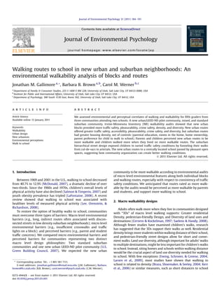
  • 6. suburban walking routes despite little density actually existing in the community. The poor pedestrian access and density along this part of the route may help account for the relationship between high density and perceived barriers to walking along the suburban route. In contrast, in the new urban community, many students’ walking routes (n ¼ 20/30) converged along blocks that featured parks or community gardens, thus creating diverse and pleasant land uses en route. 7. Discussion Our analyses of blocks address whether broad areas around students’ homes and schools differed in walkability for each community. In contrast, the analyses of walking routes address whether students are exposed to good or poor walkability along commonly used pathways. The new urban community has a more walkable design than the mixed and suburban communities, according to our multiple types of walkability assessments. First, according to trained raters’ assessments with the IMI, new urban blocks and walking routes (except for density) are more walkable and new urban routes have more consistent and pedestrian- friendly traffic safety features. Not only are new urban blocks more walkable than suburban blocks, when entire routes to school are considered, the route walkability amplifies the already significant differences found at the block level of analysis. Second, parents, students, and IMI environmental audits all agree about the walk- ability of routes to school. Third, students who report walking to school have more IMI-rated walkable routes than non-walkers. Our walking routes data illuminated planned but perhaps unanticipated consequences of suburban design. This study’s findings suggest that it does not matter if 90% of the community has walkable blocks. If the non-walkable 10% of the community’s blocks are on many children’s routes to school then these few non-walk- able blocks can act as barriers to walking for many children. Suburban children’s routes to school often originated in cul-de-sacs but ended up funneled onto an unpleasant arterial with some denser housing and poor pedestrian access. The hierarchical street forms in our study created variability in traffic conditions as suburban students emerged from low-traffic cul-de-sacs to high- traffic arterials where all non-residential necessities were sited. This combination provided too great a barrier to support walking to school. We have depicted this funneling effect in Fig. 1 (top), not replicating our exact sites (we keep the non-walkable school identity confidential), but illustrating this phenomenon more generally. Arterials often have many poor walkability features. In our case, pedestrian access was poor (sidewalks were provided on only one side of the busy streets around the suburban school) and traffic safety was variable. In other communities arterials might replicate these walking barriers or create new ones, such as signs of crime or less pleasureability. Thus, perceived walkability of suburban routes may be low, not because of unsafe suburban residential blocks but because the structure of disconnected suburban streets necessitates funneling routes along or across arterials to reach any non-residential destination. Urban planners, health officials, and other policy makers may want to take steps to avoid these problems in future designs. Iden- tifying and avoiding these “hot spots” of pedestrian barriers may facilitate walking for children, elders, and others. New communities might promote walking to school by incorporating pedestrian routes that do not include arterial streets. If a community must have arterial streets, central siting of elementary schools inside the community might enable more children to walk to school. One implication is that when children in standard suburban communities are too young to walk along arterials, they will be limited to walking among the cul-de-sacs and other interior blocks that offer little diversity of land use. If suburban children want to go to schools, stores, or visit friends who live in apartment complexes, many will require chauffeuring to reach those destinations safely. It would be interesting to examine whether the constrained pedes- trian experiences of suburban children socialize them to expect and prefer neighborhood homogeneity and automobile dependence as normative. In contrast, the design of the new urban community resulted in a more pleasant routing for children going to school. Although the new urban community blocks had higher overall residential densities than the other two communities, that density was internal to the community, not relegated to a highly trafficked exterior arterial and not sited to receive the major pedestrian flow to school. Instead, the walking routes in the new urban community were notable for their relatively high scores on diversity, pleasur- ability, crime safety and traffic safety (Table 2). Daybreak has a centrally sited school/community center, multiple small gardens, parks, and open spaces near homes, and walking paths. Thus chil- dren walking to school in the new urban community encounter high levels of traffic safety along with diverse and scenic land uses. Perhaps these early walking experiences will socialize children to expect high quality open spaces and community amenities, and to consider walking a natural form of transportation. Researchers who consider using the IMI in the future may wonder whether to use the separate, conceptually driven IMI scales or reduce walkability scores to one common factor. We like aspects of both approaches. The separate features approach may highlight aspects of community design that are under control by separate policies, such as zoning or design standards and represent distinct conceptual orientations from past research. However, an overall score provides appealing simplicity as well. In past research, density, diversity, and well-connected street designs sometimes correlate strongly (Cervero & Kockelman, 1997; Frank, Schmid, Sallis, Chapman, & Saelens, 2005), but sometimes do not (Smith et al., 2008). Future research is needed to elucidate how urban design policies and practices create patterns of walkability features and how they vary across communities and geographic levels of scale. Although this study provides considerable evidence for the walkability of the new urban community, limitations are inevitable. Residents were not randomly assigned to a community. However, as a partial counter to potential selection bias, both sociodemographic and an attitudinal control are used. We also studied the children’s shortest routes to school and could not verify whether those routes Table 5 Walkability along Routes for Walkers versus Nonwalkers: Adjusted Means and Univariate Results. Walkability scales Adjusted mean SE F (1, 137) ¼ Partial h2 Walkers Non walkers Traffic safety 0.22a 0.05b 28.90*** 0.17 0.02 0.02 Accessibility 0.00a À0.23b 31.42*** 0.19 0.02 0.03 Pleasurability 0.09a À0.01b 23.00*** 0.14 0.01 0.02 Crime safety 0.05a À0.17b 23.12*** 0.14 0.03 0.03 Density À0.11a 0.36b 40.02*** 0.23 0.04 0.05 Diversity 0.26 0.18 7.03 0.05 0.02 0.02 Note. Bonferroni adjusted (a/number of tests) to correspond to p < 0.05, p < 0.01, and p < 0.001. Subscript denotes that adjusted means differ at p < 0.003 using Bonferroni pairwise comparisons. Type I sum of squares corrected for unequal variances. Covariates were ideally walk, Rooms in home, Parental education level, and Home owner. *p < 0.008. **p < 0.002. ***p < 0.0002. J.M. Gallimore et al. / Journal of Environmental Psychology 31 (2011) 184e191 189
  • 7. were the ones taken. We examined only three communities within Salt Lake County, limiting generalizability. Furthermore, the IMI items offer imprecise measures of some important constructs (e.g., density scores are the same for a block with 1 or 15 apartment complexes). Past research has suggested that children’s perceptions of walkability are unrelated or counter-intuitively related to walking (see review in Napier et al., 2011). However, parents’ and children’s perceptions of walkability and walking behaviors converged with trained raters’ walkability audits in this study. Thus parents and children may be reliable partners in efforts to enhance walkability. 8. Conclusions This is one of the few studies that assesses micro level environ- mental walkability features for new urban and standard suburban communities. Results suggest that new urbanist claims to more walkable communities are supported. The IMI assesses walkability features that are consistent with both new urban design philoso- phies and evolving LEED-ND standards for walkability. Furthermore, the evidence for walkability in this study is multifaceted, deriving from environmental audits by trained raters, student perceptions, parent perceptions, and student reports of walking. Thus both new urban and LEED-ND designs merit consideration for their ability to support walking. Wider use of these designs and planning principles could help re-instate walking to school and within the neighbor- hood as normal and healthy activities. Acknowledgments This study was supported by a 2006 Synergy seed grant for interdisciplinary urban systems research from the Office of the Vice Fig. 1. Illustration of the concept of funneling pedestrian traffic in suburban (top) neighborhoods compared to shorter more direct pathways in new urban (bottom) neighborhoods. J.M. Gallimore et al. / Journal of Environmental Psychology 31 (2011) 184e191190
  • 8. President for Research at the University of Utah, Craig Forster, PI. We appreciate the assistance of the school principals and teachers as well as the children and their parents. We appreciate the data collection assistance of Melissa Napier, Steve Burton, Rhonda Dzierzon, Matt Jackman, Gail Meakins, Aaron Norton, Alyssa Mes- sina, Sofia Ahmed, and Shantel Thomas. We thank J.P. Goates for artwork on Fig. 1. References Ahlport, K. (2008). Barriers to and facilitators of walking and bicycling to school: Formative results from the non-motorized travel study. Health Education & Behavior, 35, 221e244. Alfonzo, M., Day, K., & Boarnet, M. (2005). Irvine Minnesota Inventory for observation of physical environment features linked to physical activity. (Training protocol). Boarnet, M. G., Anderson, C. L., Day, K., McMillan, T., & Alfonzo, M. (2005a). Eval- uation of the California Safe Routes to School legislation: Urban form changes and children’s active transportation to school. American Journal of Preventive Medicine, 28, 134e140. Boarnet, M. G., Day, K., Alfonzo, M., Forsyth, A., & Oakes, M. (2006). The Irvine- Minnesota Inventory to measure built environments: Reliability tests. American Journal of Preventive Medicine, 30, 153e159. Boarnet, M. G., Day, K., Anderson, C., McMillan, T., & Alfonzo, M. (2005b). California’s safe routes to school program: Impacts on walking, bicycling, and pedestrian safety. Journal of the American Planning Association, 71, 301e317. Braza, M., Shoemaker, W., & Seeley, A. (2004). Neighborhood design and rates of walking and biking to elementary school in 34 California communities. Amer- ican Journal of Health Promotion, 19, 128e136. Brown, B. B., & Cropper, V. L. (2001). New urban and standard suburban subdivi- sions: Evaluating psychological and social goals. Journal of the American Plan- ning Association, 67, 402e419. Brown, B. B., Werner, C. M., Amburgey, J. W., & Szalay, C. (2007). Walkable route perceptions and physical features: Converging evidence for en route walking experiences. Environment and Behavior, 39, 34e61. Calthorpe, P. (1993). Next American metropolis. Princeton, NJ: Ecology, community, and the American dream Princeton University Press. Cervero, R., & Kockelman, K. (1997). Travel demand and the 3Ds: Density, diversity, and design. Transportation Research Part D: Transport and Environment, 2, 199e219. Day, K., Boarnet, M., Alfonzo, M., & Forsyth, A. (2006). The Irvine Minnesota Inventory to measure built environments: Development. American Journal of Preventive Medicine, 30, 144e152. Ewing, R., Schroeer, W., & Greene, W. (2004). School location and student travel e analysis of factors affecting mode choice. Transportation Planning and Analysis, 2004, 55e63. Frank, L. D., Schmid, T. L., Sallis, J. F., Chapman, J., & Saelens, B. E. (2005). Linking objectively measured physical activity with objectively measured urban form: Findings from SMARTRAQ. American Journal of Preventive Medicine, 28, 117e125. Gallimore, J. M., Brown, B. B., & Werner, C. M. (2010). Rules and examples for creating consistent Irvine-Minnesota Inventory (IMI) segments with nonstan- dard streets. Unpublished manuscript, University of Utah, Salt Lake City, UT. Hubsmith, D. A. (2006). Safe routes to school in the United States. Children, Youth and Environments, 16, 168e190. Jordan School District. (2009). Jordan school district policy manual. Kerr, J., Rosenberg, D., Sallis, J. F., Saelens, B. E., Frank, L. D., & Conway, T. L. (2006). Active commuting to school: Associations with environment and parental concerns. Medicine and Science in Sports and Exercise, 38, 787e794. LaFontaine, T. (2008). Physical activity: The epidemic of obesity and overweight among youth: Trends, consequences, and interventions. American Journal of Lifestyle Medicine, 2, 30e36. Larsen, K., Gilliland, J., Hess, P., Tucker, P., Irwin, J., & He, M. (2009). The influence of the physical environment and sociodemographic characteristics on children’s mode of travel to and from school. American Journal of Public Health, 99, 520e526. Leccese, M., & McCormick, K. (2000). Charter of the new urbanism. New York: McGraw Hill. Lee, M. C., Orenstein, M. R., & Richardson, M. J. (2008). Systematic review of active commuting to school and children’s physical activity and weight. Journal of Physical Activity and Health, 5, 930e949. McDonald, N. (2007). Active transportation to school e trends among US school- children, 1969e2001. American Journal of Preventive Medicine, 32, 509e516. McDonald, N. C. (2008a). Children’s mode choice for the school trip: The role of distance and school location in walking to school. Transportation, 35, 23e35. McDonald, N. C. (2008b). Critical factors for active transportation to school among low-income and minority students: Evidence from the 2001 National House- hold Travel Survey. American Journal of Preventive Medicine, 34, 341e344. McMillan, T. E. (2007). The relative influence of urban form on a child’s travel mode to school. Transportation Research Part A: Policy and Practice, 41, 69e79. MMWR. (2005). Barriers to children walking to or from school: United States, 2004. Morbidity and Mortality Weekly Report, 54, 949e952. Napier, M. A., Brown, B. B., Werner, C. M., & Gallimore, J. (2011). Walking to school: Community design and child and parent barriers. Journal of Environmental Psychology, 31(1), 45e51. Pont, K., Ziviani, J., Wadley, D., Bennett, S., & Abbott, R. (2009). Environmental correlates of children’s active transportation: A systematic literature review. Health and Place, 15, 827e840. Riggs, T. (2006). New urbanist pioneer. Washington, DC: Urban Land Institute. Rodriguez, A., & Vogt, C. A. (2009). Demographic, environmental, access, and atti- tude factors that influence walking to school by elementary school-aged chil- dren. Journal of School Health, 79, 255e261. Rodriguez, D. A., Khattak, A. J., & Evenson, K. R. (2006). Can new urbanism encourage physical activity? Comparing a new urbanist neighborhood with conventional suburbs. Journal of the American Planning Association, 72, 43e54. Saelens, B. E., & Handy, S. L. (2008). Built environment correlates of walking: A review. Medicine and Science in Sports and Exercise, 40, S550eS566. Salmon, J., & Timperio, A. (2007). Prevalence, trends and environmental influ- ences on child and youth physical activity. Medicine and Sport Science, 50, 183e199. Schlossberg, M., Greene, J., Phillips, P. P., Johnson, B., & Parker, B. (2006). School trips e effects of urban form and distance on travel mode. Journal of the American Planning Association, 72, 337e346. Smith, K. R., Brown, B. B., Yamada, I., Kowaleski-Jones, L., Zick, C. D., & Fan, J. X. (2008). Walkability and body mass index: Density, design, and new diversity measures. American Journal of Preventive Medicine, 35, 237e244. Southworth, M., & Ben-Joseph, E. (1997). Streets for living. In B. Onken (Ed.), Streets and the shaping of towns and cities (pp. 97e130). New York: R.R. Donnellery & Sons Company. SPSS. (1988). SPSS-X user’s guide (3rd ed.). Chicago: SPSS. Steuteville, R. (2008). Directory of the new urbanism. Ithaca, NY: New Urban News Publications. Timperio, A., Ball, K., Salmon, J., Roberts, R., Giles-Corti, B., Simmons, D., et al. (2006). Personal, family, social, and environmental correlates of active commuting to school. American Journal of Preventive Medicine, 30, 45e51. U.S. Green Building Council. (2007). Pilot version: LEED for neighborhood develop- ment rating system. Washington, DC: U.S. Green Building Council. Yarlagadda, A., & Srinivasan, S. (2008). Modeling children’s school travel mode and parental escort decisions. Transportation, 35, 201e218. Zhu, X. M., & Lee, C. (2008). Walkability and safety around elementary schools: Economic and ethnic disparities. American Journal of Preventive Medicine, 34, 282e290. Ziviani, J., Scott, J., & Wadley, D. (2004). Walking to school: Incidental physical activity in the daily occupations of Australian children. Occupational Therapy International, 11, 1e11. J.M. Gallimore et al. / Journal of Environmental Psychology 31 (2011) 184e191 191