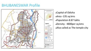
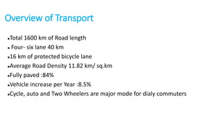
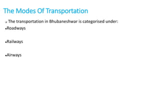
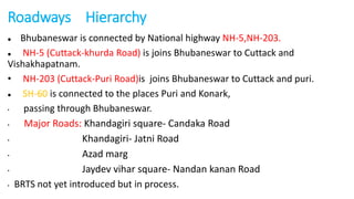
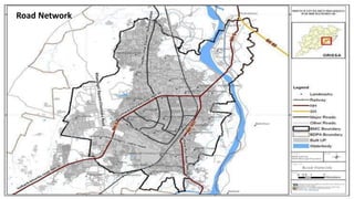
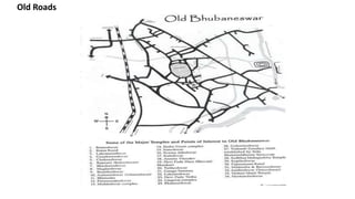
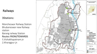
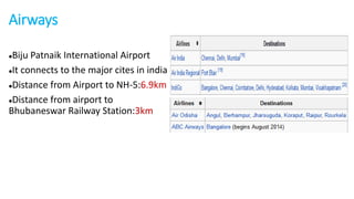
TRANSPORTATION 
IN 
BHUBANESWAR 
Kiran chappa 
2013bpln028
BHUBANESWAR Profile 
Capital of Odisha 
Area -135 sq.kms 
Population-8.87 lakhs 
Density- 4800per sq.kms 
Also called as The temple city
Overview of Transport 
Total 1600 km of Road length 
 Four- six lane 40 km 
16 km of protected bicycle lane 
Average Road Density 11.82 km/ sq.km 
Fully paved :84% 
Vehicle increase per Year :8.5% 
Cycle, auto and Two Wheelers are major mode for dialy commuters
The Modes Of Transportation 
 The transportation in Bhubaneshwar is categorised under: 
Roadways 
Railways 
Airways
Roadways Hierarchy 
 Bhubaneswar is connected by National highway NH-5,NH-203. 
 NH-5 (Cuttack-khurda Road) is joins Bhubaneswar to Cuttack and 
Vishakhapatnam. 
• NH-203 (Cuttack-Puri Road)is joins Bhubaneswar to Cuttack and puri. 
 SH-60 is connected to the places Puri and Konark, 
• passing through Bhubaneswar. 
• Major Roads: Khandagiri square- Candaka Road 
• Khandagiri- Jatni Road 
• Azad marg 
• Jaydev vihar square- Nandan kanan Road 
• BRTS not yet introduced but in process.
Road Network
Bus Stops
Access to Main Areas
Old Roads
Railways 
3Stations: 
Mancheswar Railway Station 
Bhubaneswar new Railway 
station 
Barang railway Station 
Routes FROM/TOWARDS 
1.Vishakhapatnam jn 
2.Kharagpur jn 
Barag 
Mancheswar 
Bhubaneswar
Airways 
Biju Patnaik International Airport 
It connects to the major cites in india 
Distance from Airport to NH-5:6.9km 
Distance from airport to 
Bhubaneswar Railway Station:3km
THANK YOU 
References: 
http://utbenchmark.in/UsersidePages/CityProfile.aspx?City=2 
CDP- Bhubaneshwar

transportation in Bhubaneswar

  • 1.
    TRANSPORTATION IN BHUBANESWAR Kiran chappa 2013bpln028
  • 2.
    BHUBANESWAR Profile Capitalof Odisha Area -135 sq.kms Population-8.87 lakhs Density- 4800per sq.kms Also called as The temple city
  • 3.
    Overview of Transport Total 1600 km of Road length  Four- six lane 40 km 16 km of protected bicycle lane Average Road Density 11.82 km/ sq.km Fully paved :84% Vehicle increase per Year :8.5% Cycle, auto and Two Wheelers are major mode for dialy commuters
  • 4.
    The Modes OfTransportation  The transportation in Bhubaneshwar is categorised under: Roadways Railways Airways
  • 5.
    Roadways Hierarchy Bhubaneswar is connected by National highway NH-5,NH-203.  NH-5 (Cuttack-khurda Road) is joins Bhubaneswar to Cuttack and Vishakhapatnam. • NH-203 (Cuttack-Puri Road)is joins Bhubaneswar to Cuttack and puri.  SH-60 is connected to the places Puri and Konark, • passing through Bhubaneswar. • Major Roads: Khandagiri square- Candaka Road • Khandagiri- Jatni Road • Azad marg • Jaydev vihar square- Nandan kanan Road • BRTS not yet introduced but in process.
  • 6.
  • 7.
  • 8.
  • 9.
  • 10.
    Railways 3Stations: MancheswarRailway Station Bhubaneswar new Railway station Barang railway Station Routes FROM/TOWARDS 1.Vishakhapatnam jn 2.Kharagpur jn Barag Mancheswar Bhubaneswar
  • 11.
    Airways Biju PatnaikInternational Airport It connects to the major cites in india Distance from Airport to NH-5:6.9km Distance from airport to Bhubaneswar Railway Station:3km
  • 12.
    THANK YOU References: http://utbenchmark.in/UsersidePages/CityProfile.aspx?City=2 CDP- Bhubaneshwar