BAG TECHNIQUE Bag technique-a tool making use of public health bag through wh...
The visual dictionary of universe & earth
1. U N I V E R S E &
E A R T H
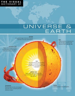
spicules
A narrow jet of gas in the form of a plume
observed in the solar chromosphere.
T H E V I S U A L
DICTION A RY OF
flare
Violent projection of extremely hot
gas into space, provoking polar
auroras on Earth a few days later.
faculae
Luminous region of the photosphere.
prominence
Gas that erupts from the chromosphere
and solar corona, contrasting with the
darkness of space.
core
The innermost part of the Sun where
hydrogen is converted into helium by
nuclear fusion; core temperatures reach
27,000,000°F.
convection zone
Region where hot gas currents
circulate between the hot regions
of the core and the cool surface.
radiation zone
Region where energy produced in the
core cools before migrating in the form of
light and heat.
4. E D I T O R I A L S T A F F
Editor: Jacques Fortin
Authors: Jean-Claude Corbeil and
Ariane Archambault
Editorial Director: François Fortin
Editor-in-Chief: Anne Rouleau
Graphic Designer: Anne Tremblay
P R O D U C T I O N
Nathalie Fréchette
Josée Gagnon
T E R M I N O L O G I C A L R E S E A R C H
Jean Beaumont
Catherine Briand
Nathalie Guillo
E N G L I S H D E F I N I T I O N S
Nancy Butchart
Rita Cloghesy
Tom Donovan
Diana Halfpenny
John Woolfrey
Kathe Roth
I L L U S T R A T I O N S
Artistic Direction: Jocelyn Gardner
Jean-Yves Ahern
Rielle Lévesque
Alain Lemire
Mélanie Boivin
Yan Bohler
Claude Thivierge
Pascal Bilodeau
Michel Rouleau
Anouk Noël
Carl Pelletier
Raymond Martin
L A Y O U T
Pascal Goyette
Danielle Quinty
Émilie Corriveau
Preliminary layout: Émilie Bellemare
Sonia Charette
D O C U M E N T A T I O N
Gilles Vézina
Kathleen Wynd
Stéphane Batigne
Sylvain Robichaud
Jessie Daigle
D A T A M A N A G E M E N T
Programmer: Éric Gagnon
Josée Gagnon
R E V I S I O N
Veronica Schami
Jo Howard
Marie-Nicole Cimon
Liliane Michaud
P R E P R E S S
Karine Lévesque
François Hénault
Julien Brisebois
Patrick Mercure
C O N T R I B U T I O N S
QA International wishes to extend a special thank you to the following people for their contribution to this book:
Jean-Louis Martin, Marc Lalumière, Jacques Perrault, Stéphane Roy, Alice Comtois, Michel Blais, Christiane Beauregard, Mamadou Togola,
Annie Maurice, Charles Campeau, Mivil Deschênes, Jonathan Jacques, Martin Lortie, Frédérick Simard, Yan Tremblay, Mathieu Blouin,
Sébastien Dallaire, Hoang Khanh Le, Martin Desrosiers, Nicolas Oroc, François Escalmel, Danièle Lemay, Pierre Savoie, Benoît Bourdeau,
Marie-Andrée Lemieux, Caroline Soucy, Yves Chabot, Anne-Marie Ouellette, Anne-Marie Villeneuve, Anne-Marie Brault, Nancy Lepage,
Daniel Provost, François Vézina, Guylaine Houle, Daniel Beaulieu, Sophie Pellerin, Tony O'Riley, Mac Thien Nguyen Hoang, Serge D'Amico.
5. IV
EDITORIAL POLICY
The Visual Dictionary takes an inventory of the physical
environment of a person who is part of today's technological age
and who knows and uses a large number of specialized terms in a
wide variety of fields.
Designed for the general public, it responds to the needs of
anyone seeking the precise, correct terms for a wide range of
personal or professional reasons: finding an unknown term,
checking the meaning of a word, translation, advertising, teaching
material, etc.
The target user has guided the choice of contents for The Visual
Dictionary, which aims to bring together in 12 thematic books the
technical terms required to express the contemporary world, in the
specialized fields that shape our daily experience.
STRUCTURE
Each tome has three sections: the preliminary pages, including the
table of contents; the body of the text (i.e. the detailed treatment
of the theme); the index.
Information is presented moving from the most abstract to the
most concrete: sub-theme, title, subtitle, illustration, terminology.
TERMINOLOGY
Each word in The Visual Dictionary has been carefully selected
following examination of high-quality documentation, at the
required level of specialization.
There may be cases where different terms are used to name the
same item. In such instances, the word most frequently used by
the most highly regarded authors has been chosen.
Words are usually referred to in the singular, even if the illustration
shows a number of individual examples. The word designates the
concept, not the actual illustration.
DEFINITIONS
Within the hierarchical format of The Visual Dictionary's
presentation, the definitions fit together like a Russian doll. For
example, the information within the definition for the term insect
at the top of the page does not have to be repeated for each of the
insects illustrated. Instead, the text concentrates on defining the
distinguishing characteristics of each insect (the louse is a
parasite, the female yellow jacket stings, and so forth).
Since the definition leaves out what is obvious from the
illustration, the illustrations and definitions complement one
another.
The vast majority of the terms in the Visual Dictionary are defined.
Terms are not defined when the illustration makes the meaning
absolutely clear, or when the illustration suggests the usual
meaning of the word (for example, the numerous handles).
METHODS OF CONSULTATION
Users may gain access to the contents of The Visual Dictionary in
a variety of ways:
• From the TABLE OF CONTENTS at the end of the preliminary
pages, the user can locate by title the section that is of interest.
• With the INDEX, the user can consult The Visual Dictionary from
a word, so as to see what it corresponds to, or to verify accuracy
by examining the illustration that depicts it.
• The most original aspect of The Visual Dictionary is the fact that
the illustrations enable the user to find a word even if he or she
only has a vague idea of what it is. The dictionary is unique in this
feature, as consultation of any other dictionary requires the user
first to know the word.
I N T R O D U C T I O N
6. 1312
flare
Violent projection of extremely hot gas
into space, provoking polar auroras on
Earth a few days later.
faculae
Luminous region of the photosphere.
chromosphere
The lowest level of the solar
atmosphere, with a temperature of
18,000°F.
spicules
A narrow jet of gas in the form of a
plume observed in the solar
chromosphere.
photosphere
Visible surface of the Sun, with a
temperature of 10,000°F.
corona
The outermost layer of the solar
atmosphere, visible in the form of a halo
during a total eclipse; corona
temperatures can reach 1,800,000°F.
convection zone
Region where hot gas currents
circulate between the hot regions of the
core and the cool surface.
radiation zone
Region where energy produced in the
core cools before migrating in the form
of light and heat.
core
The innermost part of the Sun where
hydrogen is converted into helium by
nuclear fusion; core temperatures
reach 27,000,000°F.
structure of the Sun
From the center to the periphery are the core, the
radiation and convection zones, the photosphere, the
chromosphere and the corona.
Sun
Star composed of 92.1% hydrogen atoms and 7.8% helium atoms, around which the planets gravitate;
represents more than 99.8% of the solar system’s total mass.
sunspot
A dark, slightly cooler zone of the
photosphere where the magnetic field
is more intense.
prominence
Gas that erupts from the chromosphere
and solar corona, contrasting with the
darkness of space.
solar eclipse
Obscuration of the Sun brought about by the
passage of the Moon between Earth and the
Sun.
Moon
Natural satellite of Earth.
Sun
Light source eclipsed by the Moon.
Moon’s orbit
Elliptical path of the Moon revolving
around Earth under the effect of
gravitation.
Earth
Third planet from the Sun, Earth takes
a full day to rotate once on itself, one
year to revolve once around the Sun.
umbra shadow
On Earth, the observer in this region will
see a total or annular eclipse.
penumbra shadow
On Earth, the observer in this region
will see a partial eclipse.
Earth’s orbit
Elliptical path of Earth revolving around the
Sun under the effect of gravitation.
total eclipse
Occurs when the lunar disk completely covers the
solar disk and only the Sun’s corona remains
visible.
annular eclipse
Occurs when the Moon comes between Earth and
the Sun, reducing the latter to a luminous ring.
partial eclipse
Observed by anyone within the penumbra zone
during an eclipse.
types of eclipses
There are three types of solar eclipse, based on
the degree of obscuration.
C E L E S T I A L B O D I E S C E L E S T I A L B O D I E S
Sun
V
ILLUSTRATION
It is an integral part of the
visual definition for each of the
terms that refer to it.
DEFINITION
It explains the inherent qualities,
function, or characteristics of the
element depicted in the illustration.
TITLE
Its definition is found below. If the title
refers to information that continues over
several pages, after the first page it is
shown in a shaded tone with no definition.
NARROW LINES
These link the word to the item
indicated. Where too many lines would
make reading difficult, they have been
replaced by color codes with captions
or, in rare cases, by numbers.
SUB-THEME
These are shown at the end of
the preliminary pages along
with their definitions. They are
then repeated on each page of
a section, but without the
definition.
TERM
Each term appears in the index
with a reference to the pages on
which it appears.
7. VI
C O N T E N T S
48 GEOGRAPHY
48 Configuration of the continents
64 Cartography
76 Remote sensing
82 GEOLOGY
82 Section of the Earth’s crust
84 Structure of the Earth
85 Volcano
88 Tectonic plates
90 Earthquake
92 Mountain
94 Glacier
96 Cave
98 Watercourse
100 Lakes
101 Landslides
102 Wave
104 Ocean floor
106 Ocean trenches and ridges
108 Common coastal features
111 Desert
8 CELESTIAL BODIES
8 Solar system
10 Planets and satellites
12 Sun
14 Moon
16 Comet
18 Meteorite
18 Star
20 Galaxy
22 ASTRONOMICAL OBSERVATION
22 Radio telescope
24 Reflecting telescope
25 Refracting telescope
26 Planetarium
27 Celestial coordinate system
28 Astronomical observatory
30 Hubble space telescope
32 ASTRONAUTICS
32 Space probe
38 Spacesuit
40 International space station
42 Space shuttle
45 Space launcher
8. VII
150 ENVIRONMENT
150 Vegetation and biosphere
151 Food chain
152 Hydrologic cycle
154 Greenhouse effect
158 Air pollution
160 Land pollution
162 Water pollution
164 Acid rain
166 Selective sorting of waste
169 INDEX
114 METEOROLOGY
114 Profile of the Earth’s atmosphere
115 Seasons of the year
116 Meteorological forecast
118 Weather map
120 Station model
121 International weather symbols
126 Meteorological station
128 Meteorological measuring instruments
134 Weather satellites
138 Climates of the world
140 Clouds
142 Tropical cyclone
144 Tornado and waterspout
145 Precipitations
9. 8
Sun
Star around which the planets gravitate;
represents over 99.8% of the total mass
of the solar system.
Jupiter
Fifth planet from the Sun, also the
largest; Jupiter is 1,330 times the size
of Earth.
Saturn
Sixth planet from the Sun, also the
second largest planet; Saturn is
encircled by rings forming a band
about 120,000 mi in diameter.
Kuiper belt
Circular region of the solar system
about 50 astronomical units from the
Sun; thought to be a repository of
small icy bodies, the source of comets.
Neptune
Eighth planet from the Sun; its atmosphere,
composed of hydrogen, helium and methane,
gives Neptune its bluish color. Features four
rings.
Uranus
Seventh planet from the Sun, also the third
largest planet; Uranus is composed mainly
of rock, ice and hydrogen and features
11 rings.
50 astronomical units
Corresponds to about 50 times the
Earth-Sun distance.
C E L E S T I A L B O D I E S
solar system
Region of our galaxy under the influence of the Sun; includes eight planets and their natural satellites as well as
one dwarf planet, two plutoids, asteroids and comets.
outer planets
Planets located beyond the asteroid belt; these
are known as the gas giants.
10. 9
asteroid belt
Circular region between Mars and Jupiter
containing the greatest number of
asteroids; marks the boundary between the
inner and outer planets.
inner planets
Rocky planets closest to the Sun;
located inside the asteroid belt.
Mercury
The planet closest to the Sun; devoid of
atmosphere, heavily cratered and
marked by extreme variations in
temperature (-300°F to 800°F).
Venus
Second planet from the Sun; its density
and chemical composition are similar
to those of Earth.
Mars
Fourth planet from the Sun; its crust
contains iron oxide, giving Mars its
reddish color.
Earth
Third planet from the Sun, inhabited by
humankind; up to now, the only planet with
evidence of life.
1 astronomical unit
Unit of distance equal to the mean
distance between Earth and the Sun,
equivalent to about 93 million mi.
C E L E S T I A L B O D I E S
solar system
11. 10
planets and satellites
Planets, dwarf planets and plutoids orbit the Sun, satellites orbit the planets. They are represented from left to
right from the Sun, based on their relative sizes.
Ceres
Discovered in 1801, it was promoted to
status of dwarf planet in 2006.
Mars
Fourth planet from the Sun; its crust
contains iron oxide, giving Mars its
reddish color.
Earth
Third planet from the Sun, inhabited by
humankind; up to now, the only planet
with evidence of life.
Venus
Second planet from the Sun; its density
and chemical composition are similar
to those of Earth.
Mercury
The planet closest to the Sun; devoid of atmosphere,
heavily cratered and marked by extreme variations in
temperature (-300°F to 800°F).
Ganymede
Satellite of Jupiter; the largest natural
satellite in the solar system; its glacial
surface is thought to cover an ocean
and a mantle.
Callisto
Satellite of Jupiter; its heavily cratered
surface indicates that Callisto is very old.
Europa
Satellite of Jupiter; displays a surface
layer of ice that might cover liquid
water.
Io
Satellite of Jupiter; the celestial body
with the greatest number of active
volcanoes.
Jupiter
Fifth planet from the Sun, also the
largest; Jupiter is 1,330 times the size
of Earth.
Sun
Star around which the planets gravitate;
represents over 99.8% of the total mass
of the solar system.
Moon
Earth’s only natural satellite; devoid of
water and atmosphere and
characterized by a highly uneven
surface.
C E L E S T I A L B O D I E S
12. 11
Saturn
Sixth planet from the Sun, also the
second largest planet; Saturn is
encircled by rings forming a band
about 120,000 mi in diameter.
Titan
Saturn’s largest satellite, 1.5 times the
diameter of the Moon.
Uranus
Seventh planet from the Sun, also the third
largest planet; Uranus is composed mainly
of rock, ice and hydrogen and features
11 rings.
Pluto
Discovered in 1930, it was long considered
the ninth planet of the solar system. Since
2008, it has been classified as a plutoid.
Charon
Pluto’s only satellite; almost equal in
size and mass to the planet itself.
Eris
Plutoid discovered in 2005, with a
diameter bigger than Pluto’s. It has a
satellite, Dysnomia.
Triton
Neptune’s largest satellite; together
with Pluto, Triton is the coldest object
in the solar system.
Neptune
Eighth planet from the Sun; its atmosphere,
composed of hydrogen, helium and methane,
gives Neptune its bluish color. Features four
rings.
Rhea
Satellite of Saturn; its cratered surface
is covered with ice as hard as rock.
Dione
Satellite of Saturn; its cratered surface
features ice deposits.
Tethys
Satellite of Saturn thought to be
composed of ice; visible on its surface
is an immense impact crater named
Odysseus.
Titania
The largest satellite of Uranus; its
surface displays numerous valleys and
faults.
Ariel
Satellite of Uranus; its cratered surface is
composed of numerous long valleys and
extremely high escarpments.
C E L E S T I A L B O D I E S
planets and satellites
13. 12
flare
Violent projection of extremely hot gas
into space, provoking polar auroras on
Earth a few days later.
faculae
Luminous region of the photosphere.
chromosphere
The lowest level of the solar
atmosphere, with a temperature of
18,000°F.
spicules
A narrow jet of gas in the form of a
plume observed in the solar
chromosphere.
photosphere
Visible surface of the Sun, with a
temperature of 10,000°F.
corona
The outermost layer of the solar
atmosphere, visible in the form of a halo
during a total eclipse; corona
temperatures can reach 1,800,000°F.
convection zone
Region where hot gas currents
circulate between the hot regions of the
core and the cool surface.
radiation zone
Region where energy produced in the
core cools before migrating in the form
of light and heat.
core
The innermost part of the Sun where
hydrogen is converted into helium by
nuclear fusion; core temperatures
reach 27,000,000°F.
structure of the Sun
From the center to the periphery are the core, the
radiation and convection zones, the photosphere, the
chromosphere and the corona.
Sun
Star composed of 92.1% hydrogen atoms and 7.8% helium atoms, around which the planets gravitate;
represents more than 99.8% of the solar system’s total mass.
sunspot
A dark, slightly cooler zone of the
photosphere where the magnetic field
is more intense.
prominence
Gas that erupts from the chromosphere
and solar corona, contrasting with the
darkness of space.
C E L E S T I A L B O D I E S
14. 13
solar eclipse
Obscuration of the Sun brought about by the
passage of the Moon between Earth and the
Sun.
Moon
Natural satellite of Earth.
Sun
Light source eclipsed by the Moon.
Moon’s orbit
Elliptical path of the Moon revolving
around Earth under the effect of
gravitation.
Earth
Third planet from the Sun, Earth takes
a full day to rotate once on itself, one
year to revolve once around the Sun.
umbra shadow
On Earth, the observer in this region will
see a total or annular eclipse.
penumbra shadow
On Earth, the observer in this region
will see a partial eclipse.
Earth’s orbit
Elliptical path of Earth revolving around the
Sun under the effect of gravitation.
total eclipse
Occurs when the lunar disk completely covers the
solar disk and only the Sun’s corona remains
visible.
annular eclipse
Occurs when the Moon comes between Earth and
the Sun, reducing the latter to a luminous ring.
partial eclipse
Observed by anyone within the penumbra zone
during an eclipse.
types of eclipses
There are three types of solar eclipse, based on
the degree of obscuration.
C E L E S T I A L B O D I E S
Sun
15. 14
Moon
Earth’s only natural satellite; devoid of water and atmosphere, it displays a highly uneven surface.
cliff
Steep rock face shaped by a sea.
bay
Small plain of hardened lava located
along the edges of a sea.
ocean
A very large sea.
crater
Circular basin dug out by the impact of
a meteorite.
wall
Mountain usually surrounding a cirque.
mountain range
Vestiges of the walls of a once-large
crater; semicircular in shape, it can
span hundreds of miles.
sea
Designates the vast plains of hardened
lava forming the dark regions; younger
than the highlands, these cover 15% of
the surface.
lake
Small isolated plain of hardened lava.
lunar features
Aspect of the Moon determined by past volcanic activity,
meteorite impact and soil fractures. highland
Designates bright regions riddled with
craters; these oldest regions cover
85% of the surface.
crater ray
Band that radiates from a young crater,
the result of matter ejected during a
meteorite impact.
cirque
Vast crater characterized by remarkable
relief; varies between 12 and 120 mi in
diameter.
C E L E S T I A L B O D I E S
16. 15
types of eclipses
There are two types of eclipse based on the degree
of obscuration: partial or total.
partial eclipse
When the Moon enters the umbra
shadow, its bright side diminishes little
by little.
total eclipse
Occurs when the Moon is completely
within the umbra shadow and takes on
a reddish appearance.
Sun
Light source eclipsed by Earth.
lunar eclipse
Eclipse during which the Moon enters Earth’s umbra
shadow in part or in full.
Moon’s orbit
Elliptical path of the Moon revolving
around Earth under the effect of
gravitation.
Earth’s orbit
Elliptical path of Earth revolving
around the Sun under the effect of
gravitation.
umbra shadow
When the Moon is completely in this
region, the Sun’s light no longer
reaches it; the eclipse is therefore total.
Moon
Natural satellite of Earth.
penumbra shadow
When the Moon enters this region, it
slowly ceases to be illuminated by the
Sun.
Earth
Our planet, by coming between the
Sun and the Moon, gives rise to
lunar eclipses.
C E L E S T I A L B O D I E S
Moon
17. 16
phases of the Moon
Changes in the Moon’s appearance over the
course of a month; result from the movement of
the Moon in relation to the Sun, as seen from
Earth.
new moon
The Moon lies directly between Earth and the
Sun; it is not visible, as the Sun’s light is too
brilliant.
new crescent
The Moon is visible in the early evening in the shape of a thin
crescent.
first quarter
The visible face of the Moon grows increasingly
bright; the lunar crescent gradually changes
until it forms a semi-circle after one week.
waxing gibbous
As the Moon moves away from the Sun, its shadow gradually
recedes.
coma
Cloud of gas and dust particles emitted
by the expulsion of gas from the nucleus
when a comet approaches the Sun.
nucleus
Central part of the comet; composed
mainly of ice and rocky matter.
head
Part made up of the nucleus and the
coma.
dust tail
Visible tail formed by dust particles
pushed out of the coma by pressure
from the Sun’s rays; can reach over
6 million mi in length.
C E L E S T I A L B O D I E S
Moon
comet
Small icy body that partially evaporates as it approaches the Sun; made up of a head with a solid core and tails
composed of gas and dust.
18. 17
full moon
The visible face of the Moon is completely
illuminated by the Sun’s rays.
waning gibbous
As the Moon moves closer to the Sun, its shadow begins to
obscure the Sun’s disk.
last quarter
The bright side gradually recedes until it
becomes a half-moon.
old crescent
The Moon lies to the right of the Sun and appears in the sky at
dawn in the form of a thin crescent.
ion tail
Almost invisible tail formed by the gas of
the coma pushed back by the solar wind;
can reach several hundreds of millions of
miles in length.
C E L E S T I A L B O D I E S
Moon
comet
19. 18
iron meteorite
Meteorite consisting mainly of iron and
nickel, marked by small faults.
stony-iron meteorite
The rarest class of meteorites,
characterized by the presence of almost
equal quantities of rocky matter and
metals.
meteorite
Fragment of rock, iron or another mineral that crashes into Earth instead of completely burning up as it crosses
the atmosphere.
achondrite
Meteorite whose composition is
similar to that of certain terrestrial
rocks; believed to come from the Moon
or from Mars.
stony meteorites
Meteorites composed mainly of rocky
matter. Divided into two groups:
chondrites and achondrites.
chondrite
The most common meteorite,
characterized by the presence of rock or
sulfurous matter in the form of
minuscule spheres (chondrules).
main-sequence star
Star whose mass is sufficient to generate a nuclear
reaction.
low-mass stars
Stars whose mass is less than 1.5 times that of
the Sun.
massive stars
Stars whose mass is more than 1.5
times that of the Sun; can be up to 50
times the mass of the Sun.
black hole
Results when the core of a massive star
collapses; the gravitational force is so
strong that not even light can escape.
star
A sphere of gas massive enough to generate light and heat through nuclear reactions that transform hydrogen
into helium in its core.
C E L E S T I A L B O D I E S
20. 19
brown dwarf
Star whose mass is not sufficient to
generate a nuclear reaction.
planetary nebula
Expanding gaseous envelope that
corresponds to the external layer of a red
giant that is gradually fading away.
black dwarf
Dead star, likely the residue of a dwarf
that has totally exhausted its energy
resources.
red giant
An old star whose hydrogen reserve
has been exhausted; its luminosity can
be 100 times that of the Sun.
white dwarf
An old, extremely dense star of faint
luminosity, formed by the nucleus of a
red giant contracting until it reaches
the size of Earth.
nova
A white dwarf that assimilates gaseous
matter from a neighboring star, suddenly
becoming extremely bright before it returns
to its initial brightness.
supergiant
An old, extremely luminous star of
considerable mass; its diameter can be
as much as 100 times that of the Sun.
neutron star
Star formed of compressed neutrons,
believed to be the residue of a
supernova explosion.
supernova
A supergiant that collapses onto itself
and explodes with such force that it
releases more energy than millions of
suns.
pulsar
A neutron star that rotates rapidly on
itself, thereby emitting regular radio
waves.
C E L E S T I A L B O D I E S
star
21. 20
galaxy
Grouping of stars and interstellar matter linked together by gravitation; each galaxy comprises an average of 100
billion stars.
nucleus
Central region of the bulge; the densest
and most luminous region.
spiral arm
Curved grouping of stars influenced by
the rotation of the galaxy around its
nucleus.
Milky Way
Spiral galaxy composed of 200 to 300 billion stars,
including the Sun; thought to be 10 billion years old.
Milky Way (seen from above)
From above, the Milky Way appears as a spiral
that rotates on itself around a nucleus.
Milky Way (side view)
From the side, the Milky Way appears as a
disk because its spiral arms are seen from
the same angle.
disk
The main part of the galaxy, made up of
a bulge and attaching arms.
bulge
The central bulge of the Milky Way’s
disk; the densest region of the
Milky Way, with a depth of
15,000 light-years.
globular cluster
Cluster made up of hundreds of
thousands of old stars.
halo
Region surrounding the galaxy,
inhabited by isolated stars or groupings
called globular clusters; the halo has a
radius of about 50,000 light-years.
C E L E S T I A L B O D I E S
22. 21
elliptical galaxy
Spherical or oval galaxy with no spiral arms.
lenticular galaxy
Flat, lens-shaped galaxy with a large bulge but no
arms.
normal spiral galaxy
Galaxy composed of a large nucleus from which spiral arms emerge.
Hubble’s classification
Classification of galaxies according to their form, devised by astronomer Edwin
Hubble in the 1920s; it is still used today.
barred spiral galaxy
Galaxy crossed by a bar of stars and interstellar matter; the spiral arms
emerge from the ends of the bar.
type II irregular galaxy
Rare type of galaxy whose structure obeys no
specific symmetry.
type I irregular galaxy
Rare type of galaxy that seems to possess spiral
arms without displaying a specific symmetry.
C E L E S T I A L B O D I E S
galaxy
23. 22
circular track
Rail making it possible to turn the radio
telescope horizontally so as to point it
toward a given region of the sky.
radio wave
Invisible electromagnetic waves
emitted by celestial bodies and
collected on Earth using a radio
telescope.
support structure
Structural element on the rim that prevents
the parabolic reflector from becoming
deformed.
steerable parabolic reflector
Type of adjustable radio telescope in the shape of a saucer; its power
depends on its diameter.
rotating track
Rail making it possible to turn the radio
telescope vertically so as to point it toward
a given region of the sky.
radio telescope
Instrument used to capture, concentrate and analyze radio waves emanating from a celestial body or a region of
the celestial sphere.
secondary reflector
Receives waves reflected by the
parabolic reflector and directs them
toward the receiver.
first focal room
Observation capsule used on occasion;
located in the prime focus of the radio
telescope.
parabolic reflector
A surface often composed of fine wire-
mesh that collects radio waves and causes
them to converge on a single point.
A S T R O N O M I C A L O B S E R V AT I O N
24. 23
receiver
Device that amplifies waves before they
are converted into an electrical signal.
upper laboratory
Area where the electrical signal is
filtered, digitized and transmitted to the
laboratory.
counterweight
Weight equal to that of the parabolic
reflector; makes it possible to balance
the whole.
elevator
laboratory
Area where astronomers analyze the
digital signal to obtain information.
second focal room
Secondary focus of the radio telescope
that houses the radio receiver; used
more often than the first focal room.
A S T R O N O M I C A L O B S E R V AT I O N
radio telescope
25. 24
finderscope
Small low-magnification telescope
with a wide field of view; serves to
locate celestial bodies.
eyepiece
Lens or system of lenses meant to
magnify the image when placed before
the eye.
main tube
The barrel of the telescope through which
light rays travel; houses the optical
system.
focusing knob
Adjusting device that makes it possible to obtain a
clear image of the object.
right ascension setting scale
Graduated disk indicating the right ascension of
the observed celestial body.
azimuth clamp
Clamp serving to lock the telescope along its
horizontal axis.
altitude clamp
Clamp serving to lock the telescope along its vertical
axis.
declination setting scale
Graduated disk indicating the declination of the celestial
body observed.
azimuth fine adjustment
Fine-tuning device that serves to position the telescope
horizontally.
altitude fine adjustment
Fine-tuning device that serves to position the
telescope vertically.
reflecting telescope
Optical instrument that uses an objective mirror to observe celestial bodies.
A S T R O N O M I C A L O B S E R V AT I O N
26. 25
refracting telescope
Optical instrument that uses an objective lens to observe celestial bodies.
altitude fine adjustment
Fine-tuning device serving to position the telescope
vertically.
declination setting scale
Graduated disk indicating the declination of the
celestial body observed.
azimuth clamp
Clamp serving to lock the telescope along its
horizontal axis.
altitude clamp
Clamp serving to lock the telescope along its
vertical axis.
right ascension setting scale
Graduated disk indicating the right ascension of the
observed celestial body.
tripod
Stable three-legged stand of variable
height.
azimuth fine adjustment
Fine-tuning device serving to position the telescope
horizontally.
main tube
The barrel of a telescope housing the
optical system; light rays travel
through the main tube.
finderscope
Small low-magnification telescope
with a wide field of view; serves to
locate celestial bodies.
eyepiece
Lens or system of lenses meant to
magnify the image when placed before
the eye.
A S T R O N O M I C A L O B S E R V AT I O N
27. 26
planetarium
Structure where a projector is used to simulate the movement of the celestial bodies on a dome representing half
of the celestial sphere.
zenith
Central point of the projection dome;
simulates the center of the true
celestial dome for an observer on the
ground.
auxiliary projector
Apparatus used to produce special effects.
tweeter
Loudspeaker designed to reproduce the high
frequencies of the sound signal.
projection dome
Screen representing half of the celestial
dome; the aspect of the sky at different
periods is projected onto the screen.
midrange
Loudspeaker designed to reproduce the middle
frequencies of the sound signal.
auditorium
The planetarium’s main room, built to receive
the public during a show.
control room
Premises containing the various control and
monitoring instruments required to produce a
show.
control console
Instrument that serves to manually
execute various commands for
purposes of producing a show.
planetarium projector
Projector that reproduces and simulates the
past, present and future movement of
celestial bodies.
woofer
Loudspeaker designed to reproduce the low
frequencies of the sound signal.
A S T R O N O M I C A L O B S E R V AT I O N
28. 27
A S T R O N O M I C A L O B S E R V AT I O N
celestial coordinate system
Imaginary horizontal and vertical lines used to describe the position of an object on the celestial sphere.
North celestial pole
Projection of the North terrestrial pole onto
the celestial sphere.
declination
One of two coordinates used to locate a
celestial body on the celestial sphere;
similar to terrestrial latitude.
ecliptic
Projection of the Sun’s apparent annual
path onto the celestial sphere.
right ascension
One of two coordinates used to locate a
celestial body on the celestial sphere; similar
to terrestrial longitude.
celestial meridian
Projection of a terrestrial meridian onto the
celestial sphere.
celestial sphere
Imaginary sphere where celestial bodies are
observed and positioned.
celestial equator
Projection of the terrestrial Equator onto the
celestial sphere; serves as the point of
origin for declinations.
vernal equinox
Point at which the ecliptic and the celestial
equator intersect; serves as the point of
origin for right ascensions.
South celestial pole
Projection of the South terrestrial pole onto the
celestial sphere.
Equator
Imaginary circle surrounding Earth at its
widest circumference, dividing it into two
hemispheres: the Northern hemisphere and
the Southern hemisphere.
inclination
Angle formed between an imaginary line
connecting the terrestrial poles and an
imaginary line perpendicular to the ecliptic.
29. 28
astronomical observatory
Building specially designed to house a large telescope.
polar axis
Axis parallel to Earth’s axis of rotation; its
rotation is opposite to that of Earth, making it
possible to capture fixed images of an observed
celestial body.
horseshoe mount
Mount used to support a large telescope and
point it toward the celestial pole.
telescope base
Pedestal on which the telescope mount rests.
flat mirror
Adjustable mirror making it possible to choose the
location of the focus.
hour angle gear
Drive mechanism allowing the telescope to
follow the polar axis.
primary mirror
Mirror that reflects the light of celestial
bodies, directing it toward the prime
focus.
telescope
Optical instrument that uses an
objective mirror to observe celestial
bodies.
Cassegrain focus
Focal point where the image forms;
located behind the primary mirror.
observation post
Area where most observations are carried
out.
cross section of an astronomical observatory
A S T R O N O M I C A L O B S E R V AT I O N
30. 29
dome shutter
Upper part of the dome that opens so
that light can enter the telescope.
rotating dome
Roof of the observatory that pivots on
itself so that all parts of the sky can be
observed.
exterior dome shell
Protects against foul weather.
interior dome shell
Regulates the temperature of the telescope so as to
avoid air turbulence and prevent the mirror from
becoming deformed.
coudé focus
Focal point located at a distance from
the telescope, obtained using a series of
mirrors; stationary, it is used to conduct
complex analyses and experiments.
laboratory
Area where the chemical composition of observed
celestial bodies is studied using spectroscopy.
secondary mirror
Mirror that intercepts light and
redirects it toward the Cassegrain
focus through a hole in the center of
the primary mirror. observatory
prime focus
Focal point of the primary mirror where
the light rays concentrate.
light
Emitted by the celestial body, light is
sent back toward the Cassegrain focus
by the primary and secondary mirrors.
prime focus observing capsule
Area where astronomers once gathered to monitor the
exposure time of photographic plates.
A S T R O N O M I C A L O B S E R V AT I O N
astronomical observatory
31. 30
scientific instruments
These include cameras, spectrographs
and photometers.
primary mirror
Mirror that reflects the light of celestial
bodies, directing it toward the
secondary mirror.
fine guidance system
Makes it possible to point and control the telescope with great
precision.
solar panel
Power supply device that converts solar
energy into immediately usable electrical
energy.
aft shroud
Part containing, in particular, a cooling
system that protects the scientific
instruments.
Hubble space telescope
Telescope placed in orbit above Earth’s atmosphere (370 mi), making it possible to observe the universe as
never before.
A S T R O N O M I C A L O B S E R V AT I O N
32. 31
secondary mirror
Mirror that sends light back toward the
scientific instruments through a hole in
the primary mirror.
light shield
Prevents stray light from entering the
telescope.
antenna
Conductor that transmits images to
Earth by means of a communications
satellite.
aperture door
Panel that opens and closes over the
telescope’s optical system.
A S T R O N O M I C A L O B S E R V AT I O N
Hubble space telescope
33. 32
high gain antenna
Principal antenna pointed toward Earth
to transmit large quantities of scientific
data as well as photographs.
low gain antenna
Secondary antenna used to
communicate with Earth when the high
gain antenna cannot be used.
attitude control thruster
Small rocket engine that directs the orbiter to the
desired position.
camera
Captures thousands of images, thereby
providing an overall view of the
celestial body.
orbiter (Viking)
Part of the probe that flies over a celestial body
before placing itself in orbit around the latter
and studying it; the two Viking orbiters were
launched in 1975.
infrared thermal mapper
Instrument used to analyze the surface and atmosphere of a
celestial body by measuring its temperature variations.
solar panel
Power supply device that converts
solar energy into immediately usable
electrical energy.
star tracker
Instrument that serves to direct the
probe, in Viking’s case pointing it
toward the star Canopus.
thruster engine
Machine that burns a liquid fuel
mixture, thereby providing thrust.
A S T R O N A U T I C S
space probe
Unmanned craft launched in the direction of a celestial body in the solar system for purposes of studying it.
34. 33
furlable boom
Mobile extension arm serving to dig into
the soil and collect samples.
temperature sensor
Instrument that measures the surface
temperature of the celestial body.
terminal descent engine
Rocket engine that allows the lander to
slow down before it touches the
ground.
lander (Viking)
Spacecraft designed to touch down on the
surface of the celestial body so as to study it.
camera
Two cameras make it possible to obtain
three-dimensional color images of the
celestial body’s surface. high gain antenna
Principal antenna pointed toward Earth to
transmit large quantities of scientific data as
well as photographs.
propellant tank
Place where fuel for the descent
engines is stored.
shock absorber
Piece of equipment deployed to
cushion the impact when the lander
touches down.
UHF antenna
Antenna used to establish radio contact with the
orbiter.
collector head
Shovel used to collect soil samples,
which are analyzed on-site.
radioisotope thermoelectric generator
Device that supplies electrical power; converts the heat
released by the radioactive decay of a substance it contains
into electricity.
A S T R O N A U T I C S
space probe
35. 34
examples of space probes
Since the end of the 1950s, over 125 space probes have been
launched to study the planets and satellites of the solar system.
Cassini
The Cassini probe will study Saturn, its rings
and natural satellites; Cassini is scheduled to
release the Huygens probe.
Pioneer
In 1973, Pioneer-10, en route to
Jupiter, became the first probe to cross
the asteroid belt.
Voyager
Voyager 1 and 2 transformed our knowledge of
giant planets; over 27 years after they were
launched in 1977, they continue to explore the
distant confines of the solar system.
Magellan
Placed in orbit around Venus in 1990,
Magellan is mapping 98% of its
surface.
Huygens
Huygens was designed to study Titan,
Saturn’s largest satellite.
NEAR
This probe thrust into orbit around the asteroid Eros
in 2000 and landed on it in 2001.
A S T R O N A U T I C S
space probe
Deep Impact
American probe launched in January
2005; it studied the composition of
Comet Tempel-1 by causing a collision
between the comet and an impactor.
36. 35
Venera
In 1975, Venera-9 transmitted the first
photograph of the Venusian soil before
it was crushed by the planet’s
atmospheric pressure.
A S T R O N A U T I C S
space probe
Mariner
Mariner 10 photographed the surface of
the planet Mercury three times in the
mid-1970s, revealing a world quite
similar to that of our Moon.
Mars Reconnaissance Orbiter
American probe launched in 2005;
placed in orbit around Mars, its
mission is to study the planet’s surface,
atmosphere, and climate.
New Horizons
This American probe, launched in
2006, will be the first to reach Pluto
and its satellite, Charon, in 2015; it will
then study the Kuiper belt.
Phoenix
American probe launched in August
2007, which landed on Mars in May
2008; it is studying the soil in the
planet’s arctic region.
37. 36
Apollo
Manned craft that enabled six crews to land on the
Moon between 1969 and 1972. On July 20, 1969,
Neil Armstrong and Buzz Aldrin became the first men
to explore another world.
lunar module
Inhabited section of the craft; enabled two
men to walk on the Moon and spend a few
days there before returning to dock with the
Apollo capsule.
command module
Section of the craft where the crew resided during
the mission; one astronaut stayed on board during
the Moon landing. It was the only section of the
Apollo craft to return to Earth.
service module
Houses the main propulsion system and supplies
energy, electricity, water and other provisions.
Pathfinder
Pathfinder landed on Mars in the summer of
1997. There, it deployed a small all-terrain
vehicle named Sojourner to study the
composition of the surface.
A S T R O N A U T I C S
space probe
38. 37
Stardust
Stardust’s mission is to collect
fragments of interstellar dust, hence its
name; it returned to Earth in 2006.
Ulysses
Launched in 1990, Ulysses is the only
probe to have observed the two poles
of the Sun; it is studying various types
of solar rays.
Mars Odyssey
Mars Odyssey was put into orbit around
Mars in 2001 to study its geology and
environment and to detect the presence of
underground water.
A S T R O N A U T I C S
space probe
Galileo
The first probe to thrust into orbit
around Jupiter (1995), Galileo is also
exploring the planet’s four largest
satellites.
39. 38
spacesuit
A pressurized watertight suit that provides the astronaut with oxygen and protects against solar rays and
meteorites during space walks.
35 mm still camera
A single-objective reflex camera that uses 35 mm film to capture
an image.
life support system
Module that contains, in particular, a supply of
oxygen, a cooling system and a carbon dioxide
disposal system.
communications volume controls
glove
Covered with silicone at the fingertips to provide
touch sensitivity and insulated so that objects
heated by the Sun can be picked up.
safety tether
Connects the astronaut to the shuttle, also
providing a certain mobility.
protection layer
Protects the astronaut from heat, cold
and small meteorites.
thruster
Gives the astronaut the push needed to
move away from the shuttle and to walk
in space.
A S T R O N A U T I C S
40. 39
solar shield
Translucent part of the helmet that
allows the astronaut to see and
protects against the Sun’s ultraviolet
rays.
helmet
Plastic shell that covers the head,
allowing the astronaut to breathe and
to see. color television camera
procedure checklist
A booklet containing the procedures to follow during
space walks.
helmet ring
tool tether
life support system controls
body temperature control unit
oxygen pressure actuator
manned maneuvering unit
Instrument equipped with outlets used to connect various
instruments and a propulsion system enabling the astronaut to
move around the shuttle.
A S T R O N A U T I C S
spacesuit
41. 40
truss structure
Truss frame attached to the U.S.
laboratory.
radiators
Corrugated panels ensuring heat
evacuation from the station.
photovoltaic arrays
Panels that supply power to the station
by transforming the Sun’s light into
electrical current.
Russian module
Generates the station’s electrical
energy using photovoltaic cells.
mobile remote servicer
Base that supports the arm and allows it to move
about the structure.
international space station
Complex made up of some 10 modules in orbit around Earth; built and assembled by 15 countries, it is used to
conduct scientific and technological research on weightlessness.
A S T R O N A U T I C S
42. 41
Japanese experiment module
Designed to conduct research in the life
sciences and in the science of matter; also
equipped with a platform for outside
experiments.
mating adaptor
Connector on which the space shuttle orbiter
docks during most of the station’s supply and
assembly missions.
European experiment module
Designed to conduct research in the life
and materials sciences, in physics and in
numerous other technologies.
centrifuge module
Module used to create variable
artificial gravity, making it possible to
study the effect of gravity levels on
living organisms.
remote manipulator system
Mechanical arm designed to conduct
scientific experiments on the Japanese
platform.
U.S. laboratory
Designed to carry out scientific
activities, particularly in the life
sciences and in physics.
U.S. habitation module
Designed to accommodate six
persons; contains a kitchen, roomettes,
a bathroom and first-aid equipment.
remote manipulator system
This mechanical arm is used to lift
heavy loads during the assembly of the
station and to perform maintenance
work.
crew return vehicle
Vehicle used to bring the crew back to Earth in
case of emergency.
A S T R O N A U T I C S
international space station
43. 42
orbiter
The only part of the shuttle to fly in orbit; can transport 13 tons of
material and five to seven astronauts.
space shuttle
Reusable manned space vehicle composed of an orbiter, two rockets and a fuel tank.
communication tunnel
Corridor that allows the astronauts to
go from the orbiter crew compartment
to the laboratory.
hatch
Opening that provides access to the
communications tunnel.
remote manipulator system
Mechanical arm used to handle and move shuttle
cargo.
cargo bay
Shuttle compartment that stores various
types of cargo, depending on the mission
(satellite, probe, laboratory, telescope).
flight deck
Forward section of the orbiter housing
the crew, flight-control equipment and
monitor.
surface insulation
Protects against heat so that the orbiter
does not burn up on re-entry into the
atmosphere.
attitude control thrusters
Small rocket engines that direct the orbiter to the desired
position.
heat shield
Protects the orbiter nose from heat caused by
friction when the vehicle enters the
atmosphere; covered with carbon fiber, it can
withstand temperatures over 2,900°F.
side hatch
Door allowing the crew to embark and
disembark before the launch and after
the return to Earth.
A S T R O N A U T I C S
44. 43
scientific air lock
Door making it possible to expose equipment to the space
vacuum.
scientific instruments
Varying for each mission, they make it
possible, for example, to study
meteorological conditions, pollution
and cosmic radiation.
rudder
Mobile vertical part that allows the
orbiter to set its direction when
landing.
maneuvering engine
Used to place the vehicle in orbit, to provide thrust
in case the orbit changes and to take the vehicle out
of orbit.
main engine
Each of the orbiter’s three tail engines
used during takeoff; these only function
for the first 8 min. of flight.
tank
Contains fuel for the maneuvering engines and
the directional control thrusters.
body flap
Part serving as a thermal shield for the motors
during re-entry into the atmosphere.
elevon
Each of the two ailerons controls pitching
during landing.
wing
Horizontal surface acted on by
aerodynamic forces that keep the
orbiter aloft in the atmosphere.
spacelab
Area where scientific experiments on
weightlessness are carried out.
cargo bay door
Remains open in orbit so as to expose the content of
the cargo bay to space.
radiator panel
Discharges into space the heat produced by the
functioning of onboard equipment.
A S T R O N A U T I C S
space shuttle
45. 44
space shuttle at takeoff
On takeoff, the space shuttle is made up of an orbiter, two rockets and an external fuel tank.
external fuel tank
Contains the liquid fuel (oxygen and hydrogen)
that supplies the three engines of the orbiter tail.
booster parachute
Slows the rocket’s fall after it separates from the space
shuttle some two minutes after takeoff.
solid rocket booster
Solid-fuel thruster that provides most of the lift during
the first few minutes of flight, after which it separates.
nozzle
The end portion of a rocket from which
combustion gases escape, thereby
creating the thrust needed to propel the
craft.
orbiter
The only part of the shuttle to fly in orbit;
transports 13 tons of material and five to
seven astronauts.
A S T R O N A U T I C S
space shuttle
46. 45
Delta II
In service since 1989, this highly
versatile launcher places
meteorological and communications
satellites in orbit.
Saturn V
In service from 1967 to 1973, the most
powerful rocket ever built served to launch
the Apollo missions; the only launcher never
to have failed.
Ariane IV
European Space Agency launcher; in
service from 1989 to 1997.
Titan IV
In service since 1989, this U.S.
launcher serves, in particular, to
launch large military satellites.
examples of space launchers
space launcher
Rocket that serves to place satellites in Earth’s orbit or to send probes into the solar system.
A S T R O N A U T I C S
47. 46
liquid hydrogen tank
Hydrogen, burned on contact with liquid
oxygen, serves as engine fuel.
liquid oxygen tank
Serves to burn liquid hydrogen, thereby
providing the energy needed for rocket
propulsion.
payload
Space probe or satellite carried by the
launcher.
dual launch structure
Module used to insert two independent
payloads into orbit.
solid rocket booster
Solid-fuel thruster that provides most
of the lift during the first few minutes of
flight, after which it separates.
nozzle
The end portion of a rocket from which
combustion gases escape, thereby
creating the thrust needed to propel the
craft.
fairing
The tip of the launcher that houses and
protects the payload.
storable propellant upper stage
Upper stage used to propel the payload toward its
final orbit.
main cryogenic stage
Central body that ensures propulsion
after the solid booster stage separates.
solid booster stage
Provides the main thrust during takeoff
before separating from the main cryogenic
stage.
rocket engine
Ensures launcher propulsion by means
of liquid hydrogen combustion in
contact with liquid oxygen.
cross section of a space launcher (Ariane V)
In service since 1996, this European launcher transports heavy
payloads, including the most powerful communications satellites.
A S T R O N A U T I C S
space launcher
48. 47
launch escape system
Makes it possible, in the event of damage, to separate the
command module from the rest of the launcher and to pull it.
command module
Capsule inhabited by the crew during most of an
Apollo mission; the only part of the vehicle to
return to Earth.
service module
Houses the main propulsion system and
supplies energy, electricity, water and
other provisions.
lunar module
Inhabited section of the craft; enabled two
men to walk on the Moon and spend a few
days there before returning to dock with the
Apollo capsule.
instrument unit
The brain of the rocket; includes the
computers and all of the electronic
equipment that controls the rocket during its
launch.
J-2 engine
The second and third stages are equipped with J-
2 engines; these provide thrust using liquid
oxygen-hydrogen combustion.
liquid hydrogen tank
Hydrogen, burned on contact with liquid
oxygen, serves as engine fuel. liquid oxygen tank
Contains liquid oxygen used to burn kerosene.
kerosene tank
Kerosene, burned on contact with liquid
oxygen, serves as fuel for F-1 engines.
F-1 engine
The first stage is equipped with five; it provides
thrust using kerosene-liquid oxygen
combustion.
first stage
Equipped with five F-1 engines that give the launcher the
thrust it needs to leave the launchpad; jettisoned after
2 min. 30 sec. of flight.
second stage
At an altitude of 38.8 mi, the five second-stage
engines ignite, burning for 6 min. 30 sec. before
they are jettisoned.
third stage
At an altitude of 92 mi, the third-stage engine
begins to run, allowing the launcher to place itself
in orbit before making its way toward the Moon.
payload
Includes the Apollo craft, the lunar module and the
third stage; the latter, after being placed in Earth’s
orbit, soars toward the Moon.
cross section of a space launcher (Saturn V)
Saturn V served as the launcher for the U.S. Apollo lunar exploration
program.
A S T R O N A U T I C S
space launcher
49. G E O G R A P H Y
48
configuration of the continents
The continents are vast tracts of land surrounded by water; they cover about 30% of the Earth’s surface.
planisphere
Map depicting the Earth’s two
hemispheres. Arctic
Vast region inside the north polar
circle; it includes the Arctic Ocean and
the lands bordering it.
Greenland Sea
Sea (465,000 mi2
) in the North Atlantic;
it is bordered by the coast of
Greenland.
Antarctica
The only uninhabited continent (5 million mi2
),
located inside the south polar circle; 98% of its
surface is covered with an ice cap. Antarctica holds
90% of the Earth’s freshwater reserves.
Atlantic Ocean
The world’s second largest ocean
(36 million mi2
); it covers 20% of the
Earth’s surface.
Central America
Extends from the Isthmus of
Tehuantepec in Mexico to the Isthmus
of Panama.
Pacific Ocean
The world’s largest ocean
(69 million mi2
), the Pacific covers 30%
of the Earth’s surface, more than all of the
continents put together.
50. 49
Arctic Ocean
The smallest of the oceans
(5.8 million mi2
), bordered by the northern
coasts of Asia, America and Europe; it is
largely covered with pack ice.
Indian Ocean
Relatively small ocean (29 million mi2
)
located between Africa, Asia and Australia;
it has high water temperatures and is dotted
with numerous islands.
Australia
The world’s largest island (3 million mi2
) is
sparsely inhabited in spite of its size;
because of its isolation, Australia’s wildlife
is unique.
North America
Its area (9.3 million mi2
) represents
about 16% of the world’s land; the
Central American isthmus is an
extension of North America.
South America
Represents 12% of the world’s land; linked to
North America by Central America; it includes
the Andes in the west and plains and plateaus
in east and central regions.
Oceania
Continent that represents 6% of the world’s land and
features a great many islands in the Pacific and
Indian oceans; Australia is its true continent.
Europe
Western extremity of the vast Eurasian continent
that, by convention, is separated from Asia by
the Ural Mountains; it covers a relatively small
area.
Asia
The largest and most populous
continent, Asia represents 32% of the
world’s land; it is dominated by
imposing mountain ranges.
Africa
Continent that represents about 20% of the world’s land;
two-thirds of its surface lies north of the Equator.
Characterized by very hot climates, Mediterranean in the
north and south, tropical and arid elsewhere.
Eurasia
Composed of Europe and Asia, Eurasia represents
about 39% of the world’s land; it forms a true continent
that geographers have distinguished for historical and
ethnographic reasons.
Bering Sea
Northern part of the Pacific between
Kamchatka (in Asia) and Alaska; it is
deepest in its southern portion.
configuration of the continents
G E O G R A P H Y
51. 50
Weddell Sea
Sea northwest of Antarctica, partly
delimited by the Antarctic Peninsula;
more than half of its surface is covered
with pack ice.
Antarctic Circle
Parallel of latitude at 66°34’ S that marks the
polar zone, where days and nights last
24 hours during solstices.
Drake Passage
Almost 560 mi wide, it separates Tierra
del Fuego from Antarctica and connects
the Atlantic to the Pacific; its currents
are very powerful.
Antarctic Peninsula
Extends far beyond the polar circle and
includes several mountain systems;
parts that crumble away from its tip
form small islands.
Filchner Ice Shelf
Fed by adjacent continental ice sheets
and by local precipitation; it borders
the Weddell Sea.
Marie Byrd Land
Region at an altitude of over 6,500 feet.
Pacific Ocean
From the polar circle to the continent,
this ocean is called the Antarctic.
Antarctica
The only uninhabited continent (5 million mi2
),
located inside the south polar circle; 98% of its
surface is covered with an ice cap. Antarctica holds
90% of the Earth’s freshwater reserves.
configuration of the continents
G E O G R A P H Y
52. 51
Atlantic Ocean
From the polar circle to the continent,
this ocean is called the Antarctic.
South Pole
Point of the terrestrial surface at the
southern extremity of the Earth’s axis of
rotation; the Norwegian Amundsen and his
expedition first reached it in 1911.
Queen Maud Land
Oldest and largest part of Antarctica,
Queen Maud Land also forms its
continental shelf.
Amery Ice Shelf
Its immense size makes it one of the
world’s most remarkable ice shelves.
Wilkes Land
Region of the Antarctic continent that
takes its name from a 19th-century
American mariner and explorer.
Indian Ocean
From the polar circle to the continent, this
ocean is called the Antarctic.
Ross Ice Shelf
Immense ice shelf beginning at the edge of
the continent’s southern slope.
Transantarctic Mountains
Mountain chain that is an extension of
the Andes Cordillera in South America;
its peaks reach heights of more than
13,000 feet.
configuration of the continents
G E O G R A P H Y
53. 52
Bass Strait
Some 125 mi wide and relatively
shallow, it separates continental
Australia from Tasmania.
Great Australian Bight
Located in the Indian Ocean south of
Australia, it is known for its strong
winds and rough waters.
Tasmania
Island and federal state of Australia,
from which it is separated by the Bass
Strait.
Lake Eyre North
Variable in size, Australia’s largest lake
is a salt lake.
Papua New Guinea
The eastern part of New Guinea belongs
to Oceania, while the western part of the
island is in Asia.
Indian Ocean
Relatively small ocean (29 million mi2
)
located between Africa, Asia and Australia; it
has high water temperatures and is dotted
with numerous islands.
Gulf of Carpentaria
Gulf bounded by Cape York to the east
and Arnhem Land to the west.
Torres Strait
Some 105 mi wide, the Torres Strait
connects the Pacific and Indian
oceans; it is named after a 17th-
century Spanish mariner.
Great Sandy Desert
The northernmost desert of Australia is
also the world’s second largest desert
(730,000 mi2
) after the Sahara.
Great Victoria Desert
Southernmost desert of Australia.
Oceania
Continent that represents about 6% of the world’s
land and features a great many islands scattered
between the Pacific and Indian oceans; Australia is
its true continent.
configuration of the continents
G E O G R A P H Y
54. 53
Tasman Sea
Part of the Pacific Ocean located
between Australia, Tasmania and
New Zealand. Named after a 17th-
century Dutch mariner.
New Zealand
Archipelago composed of a northern volcanic
island, the most populated island, and a
southern island crossed by a mountain range
that is deeply cut with glacial valleys.
Great Dividing Range
Mountain range extending 2,200 mi; it
includes Mount Kosciusko
(7,310 feet), Australia’s highest peak.
Fiji Islands
Archipelago composed of 326 islands,
some 100 of which are inhabited; its
principal islands are Viti Levu and
Vanua Levu.
Coral Sea
Westernmost part of the Pacific Ocean;
its warm waters (from 77°F to 82°F)
are subject to currents that reverse,
depending on the season.
Great Barrier Reef
Coral reef extending over 1,500 mi; a
Unesco World Heritage Site, it provides a
habitat for numerous forms of marine life.
New Caledonia
Mountainous island, humid and
volcanic; it is surrounded by a barrier
reef enclosing the world’s largest
lagoon.
Pacific Ocean
The world’s largest ocean
(69 million mi2
), the Pacific covers 30%
of the Earth’s surface, more than all of the
continents put together.
Melanesia
Part of Oceania (370,000 mi2
) that
includes Papua New Guinea, the
Solomon Islands, Vanuatu, New
Caledonia and Fiji.
Cook Strait
Some 9.3 mi wide, Cook Strait separates
New Zealand’s two islands.
configuration of the continents
G E O G R A P H Y
55. 54
Rocky Mountains
Eastern margin of the western
cordilleras, extending from Alaska to
Mexico.
Bering Strait
Some 62 mi wide, it connects the
Pacific Ocean to the Arctic Ocean.
Beaufort Sea
Part of the Arctic Ocean between
Alaska and the Arctic archipelago.
Mackenzie River
Canada’s longest river (2,635 mi).
Hudson Bay
Vast gulf that opens onto the Atlantic
Ocean through the Hudson Strait; the
bay is frozen seven months a year.
Gulf of Alaska
Northeast part of the Pacific Ocean,
bordering Alaska.
Aleutian Islands
Archipelago that is an extension of
Alaska; it is composed of 150 islands
and islets stretching over more than
1,000 mi.
Mississippi River
The Mississippi (2,350 mi) drainage
basin covers the entire area between
the Rocky Mountains and the
Appalachians.
Central America
Extends from the Isthmus of
Tehuantepec in Mexico to the Isthmus
of Panama.
Yucatan Peninsula
Vast plateau characterized by aridity in
the northwest and abundant
precipitation in the south, where a
dense forest grows.
Gulf of Mexico
Part of the Atlantic located between the
U.S., Mexico and Cuba.
Gulf of California
Separates the Baja California peninsula
from the continent.
Grand Canyon
The longest gorge in the world
(220 mi); the Colorado River flows
through it.
North America
The Appalachians constitute the principal relief on the
eastern part of the continent, while in the west, a high
mountain chain (the Rocky Mountains and the Sierra
Madre) follows the coast from Alaska to Mexico.
configuration of the continents
G E O G R A P H Y
56. 55
Baffin Island
Island in the Arctic archipelago; the Baffin
Sea separates it from Greenland.
Greenland
Second largest island in the world
(over 770,000 mi2
) after Australia.
Great Lakes
These five lakes constitute the world’s
largest reserve of fresh surface water
(95,000 mi2
).
Newfoundland Island
Saint Lawrence River
River (over 680 mi) that drains
southeastern Canada and empties into
the Atlantic Ocean.
Appalachian Mountains
Old massif extending over 1,200 mi
from the Canadian border to Alabama;
its highest peak is Mount Mitchell
(6,684 feet).
West Indies
Archipelago that includes more than 700 islands,
including the Greater Antilles in the north (Cuba,
Haiti, Jamaica, Puerto Rico) and the Lesser Antilles
in the east.
Caribbean Sea
Body of water (1.1 million mi2
) located
between Central America and the
northern portion of South America.
Isthmus of Panama
Cut by a canal with locks that is 50 mi long.
The Panama Canal opened in 1914 allowing
maritime traffic to travel between the Caribbean
Sea and the Pacific Ocean.
configuration of the continents
G E O G R A P H Y
57. 56
South America
Linked to North America by Central America, its
main features are the Andes Cordillera in the
west and the plains and plateaus of the central
and eastern regions.
Orinoco River
River in Venezuela (1,340 mi) that
empties into the Atlantic through a vast
delta; the volume of its flow is
considerable.
Patagonia
Plateau in Chile and Argentina; it is divided into
Andean Patagonia with a humid climate and
abundant vegetation, and the Patagonian plateau,
which is dry and sparse.
Cape Horn
Southernmost point of South America,
only 620 mi from Antarctica; famous for
its storms and dangerous reefs and
shoals.
Tierra del Fuego
Archipelago separated from the continent
by the Magellan Strait; its cold damp
climate results in perpetual snows from as
low as 2,300 feet.
Atacama Desert
Among the driest deserts on the planet,
receiving only a few inches of rain per
year.
Lake Titicaca
Located in the Andes Cordillera
between Peru and Bolivia; at an
elevation of 12,500 feet, it is the
highest navigable lake in the world.
Andes Cordillera
Longest mountain chain in the world (5,000 mi)
and the second highest, it follows the western
coast of South America; its highest peak is
Aconcagua (22,834 feet).
Gulf of Panama
Bounded in the north by the Isthmus of
Panama, its coast is uneven and dotted
with islands.
configuration of the continents
G E O G R A P H Y
58. 57
Amazon River
The largest river in the world in volume of
flow; it rises in the Andes and flows for
4,090 mi through more than 80% of
Brazil’s territory.
Equator
Imaginary circle surrounding Earth at its
widest circumference, dividing it into two
hemispheres: the Northern hemisphere and
the Southern hemisphere.
Paraná River
River (1,860 mi) with most of its course in
Brazil; it marks the boundary between
Brazil and Paraguay, and between
Paraguay and Argentina.
Falkland Islands
Archipelago composed of two main
islands separated by the Falkland
Strait, as well as some 100 islets.
Drake Passage
Almost 560 mi wide, it separates Tierra
del Fuego from Antarctica and connects
the Atlantic to the Pacific; its currents are
very powerful.
configuration of the continents
G E O G R A P H Y
59. 58
Norwegian Sea
Section of the Atlantic between Norway
to Iceland.
Iceland
Volcanic island subject to regular
earthquakes; it has over 3,100 mi of
coastline.
Scandinavian Peninsula
Vast Nordic peninsula that includes
Norway, Sweden and part of Finland.
Strait of Gibraltar
Channel (9 mi wide) between Spain and
Morocco; it connects the Mediterranean
to the Atlantic and is an important
shipping route. Mediterranean Sea
One of the world’s largest inland seas,
bordered by Europe, Africa and Asia; it
connects to the Atlantic Ocean through
the Strait of Gibraltar.
North Sea
Relatively shallow sea (220,000 mi2
) in the
North Atlantic and bordered by the coasts of
Europe; some major European ports are
located along its estuaries.
English Channel
Relatively shallow sea between France
and England; its extreme tides cause
strong currents, making navigation
difficult.
Irish Sea
Section of the Atlantic that separates
Great Britain from Ireland.
Alps
Largest mountain mass in Europe,
extending 750 mi; Mont Blanc
(15,771 feet) is its highest peak.
Pyrenees
Mountain range whose northern slope is
in France and whose southern slope is in
Spain; Pico de Aneto (11,169 feet) is its
highest peak.
Europe
Western extremity of the vast Eurasian
continent that, by convention, is separated from
Asia by the Ural Mountains; it covers a
relatively small area.
configuration of the continents
G E O G R A P H Y
60. 59
Kola Peninsula
Mostly mountainous peninsula located
in Russia, above the Arctic polar circle.
Baltic Sea
Generally shallow inland sea that is
low in salt content and devoid of major
tides; it freezes along its coasts.
Black Sea
Inland sea (162,000 mi2
) between Eastern
Europe and Asia; it opens into the
Mediterranean through two straits, the
Dardanelles and the Bosporus.
Adriatic Sea
Gulf of the Mediterranean, 520 mi long
and 110 mi wide, located between Italy,
the former Yugoslavia and Albania.
Dnieper River
River in Russia (1,350 mi) whose flow
is slow but abundant; it is a major
communications artery.
Volga River
The longest river in Europe (2,300 mi)
is ice-covered three to four months per
year; its spring flood is substantial.
Ural Mountains
Mountain range extending 1,500 mi from
the Caspian Sea to the Arctic; it is
traditionally considered the boundary
between Europe and Asia.
Carpathian Mountains
Mountain range in central Europe,
lower than the Alps; its highest point is
at an elevation of 8,711 feet.
Danube River
Second longest river in Europe
(1,770 mi); it flows into the Black Sea
through a vast delta with three
branches.
Lake Ladoga
Europe’s largest lake (6,800 mi2
) is
located in Russia; it empties into the
Baltic Sea.
Barents Sea
Area of the Arctic Ocean lying north of
the Scandinavian Peninsula and
Russia; it is partially ice-covered.
Aegean Sea
Area of the Mediterranean Sea between
Turkey and Greece; it contains
numerous islands, the largest of which
is Crete.
configuration of the continents
G E O G R A P H Y
61. 60
Asia
The largest and most populous
continent, Asia represents 32% of the
world’s land; it is dominated by
imposing mountain ranges.
Aral Sea
Sea once connected to the Caspian
Sea; it is now an immense salt lake.
Bay of Bengal
Area of the Indian Ocean between India
and the Indochinese Peninsula; the
Ganges River empties into this bay
through the world’s largest delta.
Arabian Sea
Area of the Indian Ocean between India
and the Arabian Peninsula; the Gulf of
Oman is an arm of the Arabian Sea.
Gulf of Oman
The narrowest part of the Arabian Sea;
it connects to the Persian Gulf through
the Strait of Hormuz.
Himalayas
The world’s highest mountain range; it
contains some ten peaks above
26,000 feet, including Everest
(29,035 feet).
Indian Ocean
Relatively small ocean (29 million mi2
)
located between Africa, Asia and Australia; it
has high water temperatures and is dotted
with numerous islands.
Persian Gulf
Gulf (500 mi long) bordered by Saudi
Arabia, Iran and Iraq; it is also called
the Arabian Gulf and is an important
maritime trade route.
Arabian Peninsula
Vast semiarid peninsula; it holds 50%
of the world’s oil supply.
Gulf of Aden
Northwestern arm of the Indian Ocean between
southern Saudi Arabia and northeastern Africa;
it connects to the Red Sea through the strait of
Bab El Mandeb.
Caspian Sea
The world’s largest lake (140,000 mi2
),
located between Europe and Asia; it has no
link to an ocean and is diminishing in size.
configuration of the continents
G E O G R A P H Y
62. 61
Gobi Desert
One of the largest deserts in the world
(400,000 mi2
), shared by China and
Mongolia; the Gobi is a plateau situated at
an elevation of about 3,300 feet.
Lake Baikal
The world’s oldest (25 million years) and
deepest (5,315 feet) lake; Lake Baikal is
370 mi long and 40 to 50 mi wide and is
frozen six months of the year. Kamchatka Peninsula
Russia’s easternmost peninsula
(12,000 mi2
) is characterized by
intense volcanic activity.
Sea of Japan
Area of the Pacific Ocean that separates
Japan from the Asian coast; it is
divided into a warm region and a cold
region.
Pacific Ocean
The world’s largest ocean
(69 million mi2
), the Pacific covers 30%
of the Earth’s surface, more than all of the
continents put together.
Japan
Archipelago made up of 1,000 islands,
including four main islands that
represent 95% of its territory; it is
characterized by intense volcanic activity
and frequent earthquakes.
Korean Peninsula
Peninsula that delimits the Sea of
Japan; its climate is marked by
monsoons in summer and typhoons in
the fall.
East China Sea
Area of the China Sea between Korea,
the Ryukyu Islands (south of Japan)
and Taiwan.
Philippines
Archipelago with more than 7,000
islands and islets; two principal
islands (Luzon and Mindanao) make
up 70% of its territory.
South China Sea
Southern part of the China Sea
bordering the entire southeast coast of
Asia as well as Borneo, the Philippines
and Taiwan.
Indonesia
Archipelago with almost 14,000
islands extending 3,100 mi from west
to east; it is the world’s most active
volcanic zone.
configuration of the continents
G E O G R A P H Y
63. 62
Africa
Continent that represents about 20% of the world’s land;
two-thirds of its surface lies north of the Equator.
Characterized by very hot climates, Mediterranean in the
north and south, tropical and arid elsewhere.
Cape of Good Hope
Former island now connected to the
continent by a ridge of sand; located only
90 mi to the west of Africa’s southernmost
point.
Kalahari Desert
Semiarid region bordering the Namib
Desert; the north is marshy while the
south is characterized by very sparse
vegetation.
Namib Desert
Arid region extending 1,250 mi along
the Atlantic coast. Frequent fog brings
the equivalent of 2 in of annual rainfall.
Atlantic Ocean
The world’s second largest ocean; it
covers 20% of the Earth’s surface.
Congo River
Second longest river in Africa
(2,850 mi) and the world’s second river
in size of drainage basin and volume of
flow.
Gulf of Guinea
Gulf extending from Ivory Coast to
Gabon; its waters are warm.
Niger River
Africa’s third longest river (2,600 mi)
after the Nile and the Congo.
Senegal River
River (1,050 mi) forming the boundary
between Senegal and Mauritania; it empties
into the Atlantic.
Atlas Mountains
Mountain chain composed of several
ranges; it extends from Tunisia to
Morocco, where Jebel Toubkal is its
highest peak (13,665 feet).
Sahara Desert
Largest desert in the world
(3 million mi2
); it covers one-quarter of
Africa.
Lake Chad
Large lake, shallow and marshy, the
vestige of what was once a sea; it
continues to diminish in size and could
one day dry up.
configuration of the continents
G E O G R A P H Y
64. 63
Lake Malawi
Lake shared by Malawi, Tanzania and
Mozambique; it is 310 mi long and
30 mi wide.
Indian Ocean
Relatively small ocean (29 million mi2
)
located between Africa, Asia and Australia; it
has high water temperatures and is dotted
with numerous islands.
Mozambique Channel
Arm of the Indian Ocean between the
African continent and Madagascar.
Madagascar
Island (1,000 mi long); because it is isolated
off the coast of Africa, Madagascar’s flora and
fauna are unique.
Mediterranean Sea
One of the largest inland seas in the world
(965,000 mi2
); it lies between Europe, Africa
and Asia and connects to the Atlantic Ocean
through the Strait of Gibraltar.
Nile
The world’s longest river (4,150 mi) is
known for its summer flooding.
Red Sea
Gulf (165,000 mi2
) located between
Africa and the Arabian Peninsula; it
connects to the Mediterranean through
the Suez Canal.
Gulf of Aden
Northwestern arm of the Indian Ocean between
southern Saudi Arabia and northeastern Africa;
it connects to the Red Sea through the strait of
Bab El Mandeb.
Lake Victoria
Africa’s largest lake (26,000 mi2
) is
relatively shallow; it is bordered by
Uganda, Kenya and Tanzania.
Lake Tanganyika
The world’s deepest lake (4,710 feet) after
Lake Baikal; it empties into the Congo
River.
configuration of the continents
G E O G R A P H Y
65. 64
cartography
A collective term for the techniques and graphic arts used to develop and produce maps based on direct
observation or documentation.
Earth coordinate system
The intersection of two imaginary lines, longitude and
latitude, makes it possible to locate a precise point on the
Earth’s surface.
North Pole
Point on the Earth’s surface at the
northern extremity of the axis of
rotation, where the meridians
converge.
South Pole
Point on the Earth’s surface at the
southern extremity of the axis of
rotation, where the meridians
converge.
Antarctic Circle
Parallel of latitude at 66°34’ S that marks
the polar zone, where days and nights last
24 hours during solstices.
Tropic of Capricorn
Parallel located at 23°26’ N latitude (a
distance of about 1,600 mi from the
Equator).
Equator
Imaginary line encircling the Earth at its
greatest circumference and perpendicular to
the polar axis; its latitude, 0, serves as a
reference point for calculating other latitudes.
Tropic of Cancer
Parallel located at 23°26’ N latitude (a
distance of about 1,600 mi from the
Equator).
Arctic Circle
Parallel of latitude 66°34’ N; it marks the
polar zone, where days and nights last
24 hours during solstices.
G E O G R A P H Y
66. 65
hemispheres
The globe is divided by convention
into four half spheres, using the
Greenwich meridian or the Equator as a
reference point.
Eastern hemisphere
Eastern half of the globe in relation to
the prime meridian.
Northern hemisphere
Northern half of the globe in relation to
the Equator.
Western hemisphere
Western half of the globe in relation to
the prime meridian.
Southern hemisphere
Southern half of the globe in relation to
the Equator.
G E O G R A P H Y
cartography
67. 66
grid system
Collective term for the parallels and
meridians that form an imaginary grid
over the Earth’s surface, making it
possible to locate a specific point.
lines of latitude
Coordinate of a point on the Earth’s
surface indicating, in degrees, its
distance from the Equator.
Tropic of Cancer
Parallel located at 23°26’ N latitude (a
distance of about 1,600 mi from the
Equator).
lines of longitude
Coordinate of a point on the Earth’s
surface indicating, in degrees, its
distance from the prime meridian. Eastern meridian
Imaginary line connecting the poles
and perpendicular to the Equator;
located east of the Greenwich
meridian.
prime meridian
Chosen by convention as the meridian
of origin; its longitude, 0, divides the
Eastern and Western hemispheres.
Western meridian
Imaginary line connecting the poles
and perpendicular to the Equator;
located west of the Greenwich
meridian.
parallel
Imaginary circle whose plane is
parallel to the Equator.
Antarctic Circle
Parallel of latitude at 66°34’ S that marks
the polar zone, where days and nights
last 24 hours during solstices.
Tropic of Capricorn
Parallel located at 23°26’ N latitude (a
distance of about 1,600 mi from the
Equator).
Equator
Imaginary line encircling the Earth at
its greatest circumference and
perpendicular to the polar axis; its
latitude, 0, serves as a reference point
for calculating other latitudes.
Arctic Circle
Parallel of latitude 66°34’ N; it marks
the polar zone, where days and nights
last 24 hours during solstices.
G E O G R A P H Y
cartography
68. 67
map projections
Representation of the Earth’s surface on a plane.
conic projection
Obtained by projecting the Earth’s
surface onto a cone whose base is a
parallel; it can represent only a part of
the globe.
plane projection
Produced on a plane placed in such a
way that it is tangent to a point on the
Earth’s surface; it can represent only
one hemisphere.
cylindrical projection
Obtained by projecting the Earth’s surface
onto a cylinder; the meridians and
parallels are thus straight lines
intersecting at right angles.
interrupted projection
Results in a map that is not continuous but
cut off, the divisions often placed in the
middle of the oceans; it is used to represent
the continents.
G E O G R A P H Y
cartography
69. 68
compass card
Star indicating the cardinal points and
the intermediary directions; it is
reproduced on compass dials, marine
charts and so forth.
North
Northeast
East
Southeast
South
Southwest
West
Northwest
G E O G R A P H Y
cartography
70. C A N A D AEdmonton
Vancouver
San Francisco
Los Angeles
San Diego
Denver Washington
Atlanta
Dallas
Guadalajara
Houston
Monterrey
Miami
New York
Montréal
Toronto
Detroit
Ottawa
Chicago
Calgary
Seattle
Ciudad de México
Winnipeg
U N I T E D S T A T E S
MEXICO
69
political map
Type of map representing various
countries and their territorial or
administrative units.
internal boundary
Boundary marking the territorial limits
of a province or state within a federated
state.
international boundary
Boundary marking a country’s
territorial limits.
country
Territory inhabited by a citizenry and
administered by a government; its
borders are clearly established.
state
Each of the territories constituting a
federation; the United States is divided
into 50 states.
capital
City where the government is located.
city
Major urban center, characterized by a
concentrated settlement whose activities
revolve around industry, commerce,
services and administration.
province
Territorial division run by a government
elected by the population (in Canada) or
appointed by a central authority (China).
G E O G R A P H Y
cartography
71. 70
prairie
Vast expanse of relatively flat land that
is characterized by grasses and is
naturally devoid of trees.
physical map
Type of map representing the Earth’s
surface (topography, watercourses,
aquatic areas) using various techniques
(contour lines, colors).
mountain range
A row of connected mountains
characterized by high summits and
deep valleys.
plain
Vast, relatively flat expanse of land,
lower than the surrounding landscape;
its valleys are wide and shallow.
cape
Massive elevated headland extending into
the sea or a river estuary.
gulf
Long curvature in a coastline; it
reaches far inland and is more or less
open.
plateau
Vast expanse of relatively flat land,
higher than the surrounding region
and bounded by deep valleys with
sheer cliffs.
river
Natural watercourse of minor or
intermediate size that empties into
another watercourse.
mountain mass
Group of closely spaced mountains.
G E O G R A P H Y
cartography
72. 71
bay
Indentation in a shoreline that reaches
far inland and is delimited by two
capes.
sea
Vast body of saltwater at some distance
inland; it is not as deep as an ocean.
strait
Natural arm of a sea between two coasts; it
connects two bodies of water.
island
Expanse of land completely
surrounded by water.
river estuary
Mouth of a river that is influenced by
the tides; it forms an indentation in the
coastline that varies in width and
depth.
lake
Body of water completely surrounded
by land; it varies in size and depth.
archipelago
Group of islands.
peninsula
Vast expanse of land extending into the
sea and connected to a continent.
isthmus
Narrow strip of land between two
bodies of water; it connects two larger
expanses of land.
river
Major watercourse fed by numerous
smaller rivers; it empties into the sea.
ocean
Vast body of saltwater covering a large
part of the Earth’s surface and
separating the continents.
G E O G R A P H Y
cartography
73. 72
urban map
Precise and detailed representation of
an area of a city, usually on a large
scale.
bridge
Structure allowing a communications
route to span a natural obstacle or
another communications route.
railroad station
Collective term for the network of rails and the
structures needed to transport travelers and
goods by train.
railroad line
Communications route composed of
two parallel rails along which trains
travel.
suburbs
All the cities surrounding a big city on
which they depend economically.
river
Major watercourse fed by numerous
smaller rivers; it empties into the sea.
woods
Small tract of land covered with trees.
circular route
High-speed road that circles the
downtown area, making it possible to
divert traffic away from downtown or
connect two outlying communities.
traffic circle
Junction where several roads converge
on a roadway that circles a round,
central island; traffic moves in one
direction only.
avenue
Thoroughfare larger than a street; it
services a district or an area of a city.
G E O G R A P H Y
cartography
74. 73
street
Thoroughfare built inside a city and
usually lined with buildings.
public building
Large building that houses public
services.
boulevard
Very large, high-volume thoroughfare
connecting various parts of a city.
district
Administrative area of a large city.
highway
Large thoroughfare with separate one-
way lanes and no crossing streets;
reserved for high-speed traffic.
monument
Structure that commemorates a
historic event or holds aesthetic,
religious or symbolic value.
cemetery
Place where the dead are buried.
park
Area of a city where trees are planted; it
is used for leisure.
G E O G R A P H Y
cartography
77. 76
echo
Waves reflected by the target and measured
by a remote sensing device.
airborne radar
Radar used aboard an aircraft.
target
Surface or object from which radar
waves reflect.
remote sensing
Technique that uses electromagnetic waves to obtain information about the Earth’s surface and atmosphere from
a distance.
transmitted pulse
Brief emission of electromagnetic
waves produced by a radar.
radar
Detection device that emits
electromagnetic waves and receives
their echoes.
G E O G R A P H Y
78. 77
target
Surface or object from which sonar
waves reflect.
ultrasound waves emission
Production of very high-frequency
sound vibrations whose echo is
captured and analyzed.
ship
sonar
Detection system emitting ultrasound;
it is used for detection mainly in a
marine environment.
echo
Waves reflected by the target and measured
by a remote sensing device.
remote sensing
G E O G R A P H Y
79. 78
support structure
payload module
Section of the satellite that houses
detection materials and maintenance
equipment.
bus module
Section of the satellite connected to the payload
and equipped with the resources needed to make it
function.
Radarsat satellite
Canadian-built Earth observation
satellite used to monitor environmental
changes and natural resource use.
radar antenna
Antenna designed to emit
electromagnetic wave beams and to
capture the echo reflected by the
Earth’s surface.
solar array
Power supply device that converts
solar energy into immediately usable
electrical energy.
remote sensing
G E O G R A P H Y
80. 79
sensor swath
Width of the Earth’s surface observed
during the passage of a satellite.
radar beam
Collective term for the fan-shaped
trajectories of electromagnetic waves
emitted in a given direction by a radar.
X-band antenna
Type of antenna that emits and receives
extremely high-frequency waves.
thruster
Piece of equipment that generates the
impetus required to move the satellite.
Earth sensor
Instrument that locates the Earth’s horizon so that the
radar antenna can be positioned correctly. Sun sensor
Instrument that positions the solar
panels in the direction of the Sun to
capture its energy.
remote command antenna
Type of antenna that allows the ground operation center
to transmit commands to the satellite.
remote sensing
G E O G R A P H Y
81. 80
artificial radiation
When atmospheric conditions hide the
Sun’s rays, the active sensor itself emits
radiation waves.
reflection
Phenomenon by which natural or
artificial waves bounce off the target
and toward the satellite.
target
Surface or object that reflects the Sun’s
rays.
target
Surface or object that reflects the Sun’s
rays.
natural radiation
When the sky is clear, the satellite
captures the reflection of the Sun’s rays
from the Earth’s surface.
satellite remote sensing
Observation of the Earth’s surface and
atmosphere by a satellite equipped with a
sensor.
energy source
At the origin of the remote sensing
process is an energy source, for
example the Sun, used to illuminate
the target.
passive sensor
Instrument that receives the waves
produced when the target reflects the
Sun’s natural rays.
data recording
If the satellite in unable to
communicate with the terrestrial
station, data is registered onboard and
transmitted later.
remote sensing
G E O G R A P H Y
82. 81
data transmission
The sensor transmits raw data, if
possible immediately, to a terrestrial
station for processing.
data recording
If the satellite in unable to
communicate with the terrestrial
station, data is registered onboard and
transmitted later.
data reception
Raw data reaches the terrestrial station
in digital form.
data processing
Raw data is interpreted and analyzed to
extract information about the target.
active sensor
Instrument that itself emits the energy
required to illuminate the target and
receives the waves it reflects.
remote sensing
G E O G R A P H Y
83. 82
G E O L O G Y
section of the Earth’s crust
The Earth’s crust, continental and oceanic, is composed mainly of sedimentary, metamorphic and igneous rock.
sea level
Average height of seawater observed for a
given time (day, month, year); it is used as a
reference point to define coastal features and
measure land elevations.
deep-sea floor
Part of the Earth’s surface beneath the
seas and the oceans; its topography is
highly variable.
basaltic layer
Layer of basalt, a rock denser than
granite, that forms the deep-sea floor
and is covered with various types of
debris.
sedimentary rocks
Rocks formed by the accumulation,
compaction and cementation of fragments
of eroded rock and debris left by living
organisms.
metamorphic rocks
Rocks made from igneous or
sedimentary rocks that have been
subjected to high pressure and very
high temperatures.
84. 83
G E O L O G Y
igneous rocks
Rock formed from molten magma that has cooled and
solidified inside the Earth; also called magmatic rock.
volcano
Landform built up as lava and ash are
ejected from the upper mantle during
successive eruptions, accumulating
and solidifying on the surface.
mountain range
A row of elevated connected landforms
characterized by high summits and
deep valleys.
intrusive rocks
Igneous rocks that have risen close to the
Earth’s surface.
granitic layer
Layer of granite that gives the
continents their essential form.
section of the Earth’s crust
85. 84
upper mantle
Layer of hard rock nearly 390 mi thick;
it is made up of the asthenosphere and
the base of the lithosphere.
Earth’s crust
Solid layer at the Earth’s surface whose
thickness varies from 6 mi beneath the
oceans to 35 mi beneath the
mountains.
oceanic crust
Layer forming the ocean floor; it is
thinner, denser and younger than the
continental crust.
inner core
Composed of iron and nickel, it is subject
to so much pressure that it remains in a
solid state in spite of temperatures higher
than 9,000°F; its diameter is 1,000 mi.
outer core
Composed of molten metal, it is
1,130 mi thick; the magnetic field is
caused by electric currents circulating
inside the outer core.
lower mantle
Little-known layer with a thickness of
about 1,420 mi; its slow-moving
currents, called convection currents,
are caused by temperature variations.
Gutenberg discontinuity
Zone separating the lower mantle from
the core; it is located at a depth of
about 1,800 mi.
Mohorovicic discontinuity
Zone that separates the Earth’s crust
from the asthenosphere. asthenosphere
Layer of the upper mantle with a
thickness of 125 mi; it is composed of
molten rock, on top of which the
lithospheric plates slide.
continental crust
Layer varying in thickness from 20 to
45 mi and composed mainly of granite.
It forms a number of distinct
landforms: the continents.
lithosphere
Layer from 30 to 60 mi thick that
comprises the Earth’s crust and the solid
part of the upper mantle; it is divided
into tectonic plates.
structure of the Earth
The Earth is formed of three concentric layers: the core, the mantle and the crust; these are separated by
transition zones called discontinuities.
G E O L O G Y
86. 85
examples of volcanoes
Various types of volcanoes are characterized by
the viscosity of their lava and the violence of their
eruptions.
explosive volcano
Characterized by viscous lava, it
produces powerful eruptions of rocks,
lava and gas; it also releases
pyroclastic surges.
effusive volcano
Characterized by streams of fluid lava
flowing over large areas.
volcano
Landform built up as lava and ash are ejected from the upper mantle during successive eruptions, accumulating
and solidifying on the surface.
G E O L O G Y
87. 86
cloud of volcanic ash
Ash is formed of particles less than 0.08 in
in diameter; it is composed of pulverized
magma and ground rock.
laccolith
Mass of magma that enters the Earth’s
crust and then solidifies, causing a
deformation on the Earth’s surface.
dike
Mass of magma that enters the Earth’s
crust and then solidifies in the form of
bladelike shafts that are vertical or oblique
to the layers of the Earth.
sill
Layer of magma that has solidified
between the layers of the Earth’s crust; it is
about 30 feet thick and several miles long.
fumarole
Regular emission of gas from a fissure
on the Earth’s surface.
volcano during eruption
Eruption of magmatic matter (molten rock,
ash, gas) from the upper mantle; it can last
several years.
geyser
Hot water spring that ejects sporadic
jets of water and vapor.
G E O L O G Y
volcano
88. 87
crater
Depression whose center features a
chimney through which lava, gas and
volcanic ejecta escape.
volcanic bomb
Mass of magma ejected high into the
air where it solidifies; it can be very
large.
main vent
Conduit along which lava and other
volcanic ejecta rise.
side vent
Small rise that appears on the side of
the volcano and is fed by the main
vent.
lava layer
Layer of volcanic rock formed by
cooled lava.
magma chamber
Pocket where magma accumulates
before rising to the surface.
magma
Molten rock and gas under very high
pressure that can reach extremely high
temperatures.
lava flow
Lava mass pouring from a volcano at
average speeds of 980 feet per hour; it
can reach temperatures as high as
2,200°F.
ash layer
Ash and lava form the layers that shape
the volcano over time.
G E O L O G Y
volcano
89. 88
Pacific Plate
The only entirely oceanic plate, it is
also among the most rapidly shifting
plates (4 in per year).
Caribbean Plate
Plate subducting under the American
plates; the Caribbean Plate created the
islands of the Lesser Antilles.
Nazca Plate
One of the most rapidly shifting plates,
moving 3 in per year.
Scotia Plate
Small plate under which the Antarctic
Plate and part of the South American
Plate are sliding.
South American Plate
Plate that forms the Andes cordillera by
means of subduction with the Nazca
Plate.
North American Plate
Together with the Pacific Plate, this
plate creates the San Andreas Fault
(750 mi), which extends from the Gulf
of California to San Francisco.
Cocos Plate
Plate along the coast of Mexico and
Central America; it is sinking beneath
the North American Plate and the
Caribbean Plate.
tectonic plates
Immense portions of the lithosphere that slide over the asthenosphere; this shifting movement shapes the
Earth’s topography.
G E O L O G Y