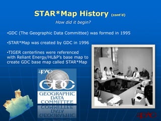
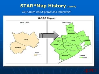
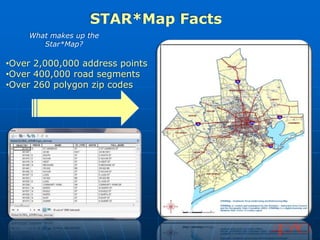
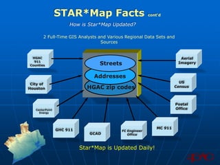
H-GAC’s Regional Base Map:

    STAR*Map


               Robert LaBarbera
               GIS Program Manager
               H-GAC Data Services Department
               Robert.LaBarbera@H-GAC.com
STAR*Map History
               What does it stand for?

The acronym STAR*Map is the trademarked name for
the Southeast Texas Addressing and Referencing Map.


              STAR*Map
STAR*Map History                  (cont’d)

                      How did it begin?

•GDC (The Geographic Data Committee) was formed in 1995

•STAR*Map was created by GDC in 1996

•TIGER centerlines were referenced
with Reliant Energy/HL&P’s base map to
create GDC base map called STAR*Map
STAR*Map History                (cont’d)

How much has it grown and improved?
STAR*Map Current Status
        How is it being improved upon presently?


• Next Generation 911 (NextGen): New National
Emergency Number (NENA) Standard fields being
added as of January 2012

• Transportation Network: New road functional
classes being added and updated as of February
2011
STAR*Map 911 Field Updates
              Fields Added for
 Next Generation 911 Database and Software

•Added EFFECTIVE Date

•Added COUNTRY String 2     Next Generation 911

•Added NO_MSAG L_int

•Added C1_EXCEPTION L_int      MapSAG
STAR*Map 911 Applications
           How is Star*Map saving lives?


•Star*Map 911 Uses:
•Pinpointing Emergency Call
Locations
•Emergency Planning Before
Events
•Damage Assessment After Events
STAR*Map Future
     How will Star*Map Shape the future of transportation
                       in the region?

Star*Map is being developed to assist our region’s
           Major Thoroughfare Plans…
                                               FUNC_CLASS           FC_CODE

                                               INTERSTATE              1

                                               URBAN FREEWAY           2

                                               PRINCIPAL ARTERIAL      3

                                               MINOR ARTERIAL          4

                                               MAJOR COLLECTOR         5

                                               MINOR COLLECTOR         6
STAR*Map Future             cont’d


…And, it will take a bigger role with transportation
                 network analysis!
    H-GAC Transportation GIS Analysts
    currently use the Star*Map to
    update and rectify their modeling
    networks
STAR*Map Facts
    What makes up the
       Star*Map?

•Over 2,000,000 address points
•Over 400,000 road segments
•Over 260 polygon zip codes
STAR*Map Facts                          cont’d

                      How is Star*Map Updated?

        2 Full-Time GIS Analysts and Various Regional Data Sets and
                                  Sources


 HGAC                                                                   Aerial
  911
Counties                          Streets                              Imagery


                                Addresses
                                                                        US
 City of
Houston                      HGAC zip codes                           Census


                                                                      Postal
   CenterPoint                                                        Office
     Energy


                                                             MC 911
                 GHC 911                   FC Engineer
                              GCAD            Office


                           Star*Map is Updated Daily!
STAR*Map Facts                                   cont’d

Who uses the Star*Map besides H-GAC staff?


                  Governments

           Harris, GHC 911,HCAD, TNRIS, TxDOT,etc.


          Private Sector Agencies

      Alterra Technologies Inc, Eureka Cartography, etc.


    Educational and Non-Profit Institutes

       Rice University, Texas A&M , HISD, etc.


                 Consulting Firms

     Transfinder, Pate Engineers Inc, The Goodman corporation, etc.
Any
      Questions?


Robert LaBarbera
GIS Program Manager
H-GAC Data Services Department
Robert.LaBarbera@H-GAC.com

The Star Map

  • 1.
    H-GAC’s Regional BaseMap: STAR*Map Robert LaBarbera GIS Program Manager H-GAC Data Services Department Robert.LaBarbera@H-GAC.com
  • 2.
    STAR*Map History What does it stand for? The acronym STAR*Map is the trademarked name for the Southeast Texas Addressing and Referencing Map. STAR*Map
  • 3.
    STAR*Map History (cont’d) How did it begin? •GDC (The Geographic Data Committee) was formed in 1995 •STAR*Map was created by GDC in 1996 •TIGER centerlines were referenced with Reliant Energy/HL&P’s base map to create GDC base map called STAR*Map
  • 4.
    STAR*Map History (cont’d) How much has it grown and improved?
  • 5.
    STAR*Map Current Status How is it being improved upon presently? • Next Generation 911 (NextGen): New National Emergency Number (NENA) Standard fields being added as of January 2012 • Transportation Network: New road functional classes being added and updated as of February 2011
  • 6.
    STAR*Map 911 FieldUpdates Fields Added for Next Generation 911 Database and Software •Added EFFECTIVE Date •Added COUNTRY String 2 Next Generation 911 •Added NO_MSAG L_int •Added C1_EXCEPTION L_int MapSAG
  • 7.
    STAR*Map 911 Applications How is Star*Map saving lives? •Star*Map 911 Uses: •Pinpointing Emergency Call Locations •Emergency Planning Before Events •Damage Assessment After Events
  • 8.
    STAR*Map Future How will Star*Map Shape the future of transportation in the region? Star*Map is being developed to assist our region’s Major Thoroughfare Plans… FUNC_CLASS FC_CODE INTERSTATE 1 URBAN FREEWAY 2 PRINCIPAL ARTERIAL 3 MINOR ARTERIAL 4 MAJOR COLLECTOR 5 MINOR COLLECTOR 6
  • 9.
    STAR*Map Future cont’d …And, it will take a bigger role with transportation network analysis! H-GAC Transportation GIS Analysts currently use the Star*Map to update and rectify their modeling networks
  • 10.
    STAR*Map Facts What makes up the Star*Map? •Over 2,000,000 address points •Over 400,000 road segments •Over 260 polygon zip codes
  • 11.
    STAR*Map Facts cont’d How is Star*Map Updated? 2 Full-Time GIS Analysts and Various Regional Data Sets and Sources HGAC Aerial 911 Counties Streets Imagery Addresses US City of Houston HGAC zip codes Census Postal CenterPoint Office Energy MC 911 GHC 911 FC Engineer GCAD Office Star*Map is Updated Daily!
  • 12.
    STAR*Map Facts cont’d Who uses the Star*Map besides H-GAC staff? Governments Harris, GHC 911,HCAD, TNRIS, TxDOT,etc. Private Sector Agencies Alterra Technologies Inc, Eureka Cartography, etc. Educational and Non-Profit Institutes Rice University, Texas A&M , HISD, etc. Consulting Firms Transfinder, Pate Engineers Inc, The Goodman corporation, etc.
  • 13.
    Any Questions? Robert LaBarbera GIS Program Manager H-GAC Data Services Department Robert.LaBarbera@H-GAC.com