TGS EUR- East Shetland Basin 3D
•
0 likes•383 views

This document provides information about new 3D seismic surveys conducted in the East Shetland Basin by TGS and PGS. It notes that the surveys covered 2,800 square km and provide higher density data that improves imaging and resolution to further explore hydrocarbon potential. The surveys are expected to better image faults, flanks, and other structures that are key to plays in the basin. They may also help identify new opportunities in areas like fault terraces and slumped blocks.

More Related Content
Similar to TGS EUR- East Shetland Basin 3D
Similar to TGS EUR- East Shetland Basin 3D (20)
More from TGS
More from TGS (20)
Recently uploaded
Recently uploaded (20)
TGS EUR- East Shetland Basin 3D
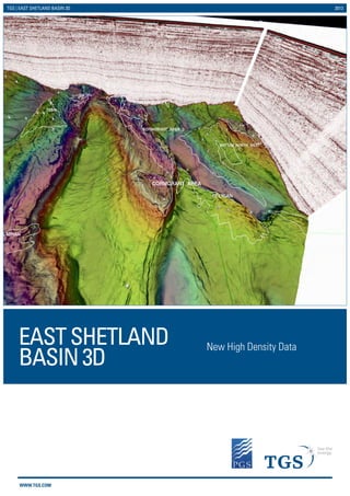
- 1. WWW.TGS.COM TGS | EAST SHETLAND BASIN 3D 2013 New High Density Data EASTSHETLAND BASIN3D
- 2. WWW.TGS.COM EAST SHETLAND BASIN !( !( !( !( !( !( !( !( !( !( !( !( !( !( !( !( !( !( !( !( !( !( !( !( !( !( !( !( !( !( !( !( !( !( !( !( !( !( !( !( !( !( !( !( !( !( !( !( !( !( !( !( !( !( !( !( !( !( !( !( !( !( !( !( !( !( !( !( !( !( !( !( !( !( !( !( !( !( !( !( !( !( !( !( !( !( !( !( !( !( !( !( !( !( !( !( !( !( !( !( !( !( !( !( !( !( !( !( !( !( !( !( !( !( !( !( !( !( !( !( !( !( !( !( !( !( !( !( !( !( !( !( !( !( !( !( !( !( !( !( !( !( !( !( !( !( !( !( !( !( !( !( !( !( !( !( !( !( !( !( !( !( !( !( !( !( !( !( !( !( !( !( !( !( !( !( !( !( !( !( !( !( !( !( !( !( !( !( !( !( !( !( !( !( !( !( !( !( !( !( !( !( !( !( !( !( !( !( !( !( !( !( !( !( !( !( !( !( !( !( !( !( !( !( !( !( !( !( !( !( !( !( !( !( !( !( !( !( !( !( !( !( !( !( !( !( !( !( !( !( !( !( !( !( !( !( !( !( !( !( !( !( !( !( !( !( !( !( !( !( !( !( !( !( !( !( !( !( !( !( !( !( !( !( !( !( !( !( !( !( !( !( !( !( !( !( !( !( !( !( !( !( !( !( !( !( !( !( !( !( !( !( !( !( !( !( !( !( !( !( !( !( !( !( !( !( !( !( !( !( !( !( !( !( !( !( !( !( !( !( !( !( !( !( !( !( !( !( !( !( !( !(!( !( !( !( !( !( !( !( !( !( !( !( !( !( !( !( !( !( !( !( !( !( !( !( !( !( !( !( !( !( !( !( !( !( !( !( !( !( !( !( !( !( !( !( !( !( !( !( !( !( !( !( !( !( !( !( !( !( !( !( !( !( !( !( !( !( !( !( !( !( !( !( !( !( !( !( !( !( !( !( !( !( !( !( !( !( !( !( !( !( !( !( !( !( !( !( !( !( !( !( !( !( !( !( !( !( !( !( !( !( !( !( !( !( !( !( !( !( !( !( !( !( !( !( !( !( !( !( !( !( !( !( !( !( !( !( !( !( !( !( !( !( !( !( !( !( !( !( !( !( !( !( !( !( !( !( !( !( !( !( !( !( !( !( !( !( !( !( !( !( !( !( !( !( !( !( !( !( !( !( !( !( !( !( !( !( !( !( !( !( !( !( !( !( !( !( !( !( !( !( !( !( !( !( !( !( !( !( !( !( !( !( !( !( !( !( !( !( !( !( !( !( !( !( !( !( !( !( !( !( !( !( !( !( !( !( !( !( !( !( !( !( !( !( !( !( !( !( !( !( !( !( !( !( !( 631 037 632 509 S 050 089 037 037 509 S 509 S 509 S 152 631 043 509 S 509 S 043 679 S 040 509 BS 375 C 679 S 040 037 D 509 S 037 C 043 BS 277 509 S 277 037 F 037 F 037 B 050 B 043 BS 037 E 050 D 037 F 043 BS 043 CS 043 DS 3 2 211 210 33 29 30 34 NINIAN BRENT GAS LYELL TERN CLADHAN BROOM CHEVIOT 2/9 3/6 2/14 2/4b 2/3 3/13b 2/8 2/15b 2/10a 2/5 211/17 3/11a 3/2a 3/5 3/1b 3/9c 210/18 211/28b210/30b 2/13 3/8d 211/24c 211/16b 3/7d 3/7c 33/12d 3/4c 3/3b 3/12b 3/12a 210/25b 3/9a 33/9a 3/2b 3/15a 3/1a 3/10c 33/9c 2/19 210/19a 2/20 210/29b 3/14a 3/16 3/3F1 210/20e 210/24a 3/17 33/9d 210/23b 33/6f 211/19a 2/5F1 3/18 3/4b 3/8a 211/27a 210/20a 3/3a 210/19b 211/29F1 3/19a 34/7a 211/29b 211/18b 210/28a 33/9b 29/3aUP 211/21b 210/28b 3/11c 211/22aNW 34/10a 210/24c 3/15b 29/3aLW 2/18 3/14j 210/29c 211/22b 211/23d 30/1bUP 211/27d 211/26aF1 211/22aSE 211/26c 2/5F2 211/30b 211/11b 211/26a 211/21aF1 33/12a 211/21a 3/4aF3 3/20a 210/14 3/14f 211/23e 210/23a 210/15a 30/4d 3/1c 33/12h 211/16a 210/25aF1 3/7aF1 211/18c 211/26d 210/29a 3/2c 210/13 3/14h 2/15a 2/10b 33/9e 3/9e 211/18aF1 33/12b 30/4bUP 211/13b 211/27e 210/30a 33/6e 3/8aF4 29/6a 211/14 30/4a 3/8b 211/12b 30/1c 211/12a 211/24a 211/19aF3 210/24b 29/6dUP 30/7a 3/14i 3/14e 211/18aF4 3/8c 29/3b 211/24b 211/23a2F1 211/23a1 29/6bUP 29/6dLW 211/29a 3/20c 3/4aS 3/15c 211/19b 2/4a 3/10a 3/4aF1 29/3cUP 33/9g 29/6bLW 211/26b 29/9a 29/3cLW 3/9b 3/9d 211/212a5 3/14d 33/9bF1 211/13aF2 211/23a1F2 34/4b 3/11b 3/14b 3/4aF2 211/18aF5 3/14c 3/8f 30/4cUP 211/21a3F1 211/27c 33/12g 3/1aN 210/20d 211/21aS 211/21a4 STATFJORD (NORWAY) ALWYN NORTH PELICAN HUTTON NORTH WEST CORMORANT NORTH HUTTON DUNBAR DUNLIN THISTLE COLUMBA E JURA HEATHER (LUNDIN) STAFFA COLUMBA B FORVIE AREA OSPREY EIDER MARTIN LINGE STATFJORD (UK) HUDSON MURCHISON (UK) STRATHSPEY HEATHER(TARABAND) GRANT NUGGETS COMPLEX DELTA KERLOCH OTTER STATFJORD EAST DON NORTH EAST MERLIN STATFJORD NORTH KESTREL DON SOUTH WEST FIONN COLUMBA D CORMORANT - SOUTH HEATHER SOUTH WEST SKYE ELLON ISLAY GULLFAKS SATELLITES ORLANDO SYGNA DEVERON DON WEST VIGDIS PLAYFAIR WESTERN ISLES PENGUIN CLUSTER 211/22 (Area 3) 003/03 (Area 8) CAUSEWAY MURCHISON (NORWAY) CORMORANT EAST SKINFAKS SOUTH 003/09 (Area 7) 003/12 (Area 2) 003/07 (Area 3) WEST LYELL CONRIE 003/08 (Area 12) 0029/03 (Area 1) GULLTOPP 002/10 (Area 1) MAGNUS SOUTH 003/10 (Area 1) BALVENIE BARNACLE TORDIS 211/28a 3/10b 211/29c 211/27bF1 211/23a2 34/10b 2/4aF1 211/25b 210/24aF1 211/18aF2 211/18aF6 33/12aF2 211/23f 211/27f 211/23c 211/16c 210/25a 33/12c 30/1bLW 3/8aF3 33/12f 211/23a3 211/19aF2 3/7aN 3/7bF1 3/13a 211/23a1F3 210/20f 211/13aF1 211/23b 3/8e 30/4cLW 33/12e 211/21aF3 34/10d 3/14g 29/6cLW 211/19aF1 211/26aW 3/8aF2 3/8eF1 211/25a 211/18aF3 211/21a3F2 211/13c 211/27aF1 211/27b 211/23a2F2 29/6cUP 211/26aN 211/14F1 29/6eLW 29/6eUP 211/27cF1 29/6cCS 211/13aE 211/29aF2211/30aF1 211/19s TGS has used its best efforts to produce this map free of errors, utilization of same shall be at the sole risk of the user. TGS assumes no liability or responsibility for reliance placed thereon. WK800_ESB_Flyer 20 MARCH 2013 ESB 3D Projection: WGS 1984, UTM Zone 31N Legend ESB10 3D ESB09 3D ESBRE09 3D 0 0.9 1.8 2.7 3.6 4.50.45 Kilometers 0 6 12 183 km ESB10, ESB09 ESB00RE09 TGS | EAST SHETLAND BASIN 3D 2013 Ramform Viking EAST SHETLAND BASIN - LOCATION MAP INTRODUCTION The East Shetland Basin survey (ESB09/10) is a joint TGS/PGS venture which provides: ƒƒ 2,800 km2 of new multi-client 3D high density data ƒƒ Significant upgrade on previous data in this area ƒƒ Improved imaging and resolution to further explore this mature area and unlock future potential Additionally TGS has reprocessed ESB00, acquired in 2000, with the latest processing technology. Hence ESB00-RE09 complements both the ESB09 and ESB10 surveys. GEOLOGY AND PROSPECTIVITY The ESB surveys span several blocks within the East Shetland Basin, a failed rift basin within the Northern North Sea. The surveys cover established fields such as the Cormorants, Hutton and NW Hutton which produce from the Jurassic Brent formations, the main oil producing reservoir of the North Sea. High density 3D data, with its associated improved sampling, means that faults and flanks are better imaged, which is key in this area where tilted fault blocks are the main play. The ESB surveys will enable geoscientists to exploit more fully existing Mesozoic discoveries and will also provide new insight into the remaining exploration potential of the East Shetland Basin which is understood to include: ƒƒ Hanging-wall fault terraces to large tilted fault blocks for Brent, Banks and Heron Groups reservoirs ƒƒ Slumped blocks of likely Brent and Banks Group reservoirs on the fault scarp of large tilted fault blocks ƒƒ Near field satellites with challenging lateral fault seal risk requiring enhanced 3D seismic imaging ƒƒ Combined structural and stratigraphic traps for Late Jurassic submarine fan systems ƒƒ Intra-Kimmeridge Clay sandstone reservoir targets of limited areal distribution ƒƒ Late Jurassic shore-zone sands along the western basin margin, offering excellent reservoir properties due to shallow depth of burial. There has been some significant success recently with this type of play and our new data adds resolution and definition to bring out similar opportunities ƒƒ Combined structural and stratigraphic traps of the Palaeocene – Early Eocene, previously little targeted by drilling within this basin except above the principal Jurassic structural highs This area has the potential to be re-interpreted for missed plays with this state of the art modern data set which provides a step change in imaging quality. VESSEL DETAILS - RAMFORM VIKING AND OCEAN EXPLORER Ramform Viking is a fully equipped high capacity seismic acquisition vessel, capable of towing up to 16 streamers. Ramform Viking was built in 1998 by Langsten SB, Norway. She is 86 m long, has a beam of 39 m with a gross tonnage of 9456 tonnes and accommodation for 60 people. As well as comprehensive acquisition capability, she is fully equipped for on-board seismic QC and processing, including PGS Cube Manager Seismic Processing Software and Holoseis Hi-End Visualisation System. Ramform Viking is in full compliance with SOLAS, Marpol 73/78 and other relevant maritime and industrial standards, EP Forum and IAGC requirements. Further documentation and certification available on request. Ocean Explorer is a six streamer 3D seismic vessel equipped with up to date acquisition and onboard processing systems. She is 81 m long, has a beam of 18 m, weighs 4458 tonnes gross and has accommodation for 60 people. She has full on-board processing capability. Ocean Explorer is in full compliance with SOLAS, Marpol 73/78 and other relevant maritime and industrial standards, EP Forum and IAGC requirements. Further documentation and certification available on request. ACQUISITION PARAMETERS Source: 2 x 3111 in3 Sodera G Gun Arrays at 6 m and 2000 psi Source separation: 25 m Sub-array separation: 8 m Source length: 14 m Streamer type RDH (solid and fluid hybrid) Streamer Viking: 16 x 4800 m (12 x 4800 m in September) Streamer Ocean: 6 x 4800 m Streamer spacing: 50 m Streamer depth: 8.5 m Near trace offset 200 m Record length 6656 ms
- 3. WWW.TGS.COM © 2013 TGS-NOPEC GEOPHYSICAL COMPANY ASA. ALL RIGHTS RESERVED. TGS | EAST SHETLAND BASIN 3D 2013 TGS Tel: +44 (0) 1234 272122 Email: EURsales@tgs.com For more information, contact: Example Dip Line PGS Email: europeinfo@pgs.com