SlideShare a Scribd company logo
1 of 2
Download to read offline
See the energy at TGS.com
© 2016 TGS-NOPEC Geophysical Company ASA. All rights reserved.
Lund
Henderson
Lloyd Ridge
Destin Dome
Atwater Valley
De Soto Canyon
Keathley CanyonAlaminos Canyon
Florida Plain
Galveston
High Island
Vermilion
Lund South
Port Isabel
Pensacola
Ship Shoal
Amery Terrace
Brazos Area
Eugene Island
Mobile
West Cameron
East Cameron
Mustang Island
Main Pass
Viosca Knoll
South Timbalier
Viosca Knoll
Sigsbee Escarpment
Matagorda Island
Corpus Christi
Ewing Bank
West Delta
Grand Isle
High Island
South Addition
West Cameron
South Addition
sland
uth Padre Island
High Island
E. Add, S. Ext
Galveston
South Addition
West Cameron
West Addition
Main Pass
S. & E. Addition
Mustang Island
East Addition
Vermilion
South Addition
South Pass
Ship Shoal
South Addition
East Cameron
South Addition Eugene Island
South Addition
North Padre Island
East Addition
High Island
East Addition
Breton Sound
South Padre Island
East Addition
Brazos
South Addition
South Marsh Island
South Timbalier
South Addition
Chandeleur
South Marsh Island
South Addition
South Pelto
South Marsh Island
North Addition
West Delta
South Addition
Port Isabel
TEXAS
LOUISIANA
MISSISSIPPI
ALABAMA
FLORIDA
87°W88°W89°W90°W91°W92°W93°W94°W95°W96°W97°W
TGS-NOPEC has used its best efforts to produce this map free of errors, utilization of same shall be at the sole risk of the user.
TGS-NOPEC assumes no liability or responsibility for reliance placed thereon.
GULF OF MEXICO
MULTI-CLIENT 3D PROJECTS
N:PublicGISArc Map DocumentsGoMWorks_In_ProgressFeliciaBGOM_PWA_7Mar2016.mxd March 07, 2016
Projection: WGS 1984 UTM Zone 15N
0 10 20 30 405
Miles
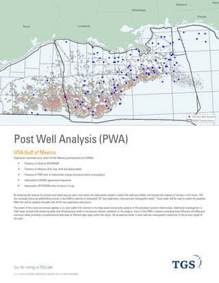
TGS PWA Wells
Post Well Analysis (PWA)
USA Gulf of Mexico
Exploration successes occur when all the following prerequisites are fulfilled:
ƒƒ Presence of effective RESERVOIR
ƒƒ Presence of effective SEAL (top, fault and lateral seals)
ƒƒ Presence of TRAP prior to hydrocarbon charge (structural and/or stratigraphic)
ƒƒ Hydrocarbon CHARGE (generation/migration)
ƒƒ Hydrocarbon RETENTION after formation of trap
By analyzing the reasons for success and failure we can learn more about the hydrocarbon system in which the well was drilled, and improve the
chances of success in the future. TGS has reviewed historical well/drilling activity in the GOM to identify an estimated 100 key exploratory, discovery and
stratigraphic wells. These wells will be used to create the baseline PWA that will be updated annually with 20-40 new exploratory data points.
The extent of this study and annual updates is to cover wells from onshore to the deep water and provide analysis of the petroleum systems
relationships. Additional investigations in Field areas provide both producing wells and offsetting lead wells to incorporate relevant validation of the
analysis. Focus of the PWA is towards emerging lower Miocene and Mesozoic reservoirs while providing a comprehensive data base of different play
types within the region. All prospective levels in each well are investigated irrespective of the primary target of the well.
© 2016 TGS-NOPEC Geophysical Company ASA. All rights reserved.
Well and Seismic Data
The following data sources provide input to the analysis:
ƒƒ TGS LAS+ composite logs, well reports, etc.
ƒƒ TGS and BOEM paleo analysis to provide litho-/
chronostratigraphy
ƒƒ TGS petrophysical database (CPI)
ƒƒ General Production data from TGS Longbow well performance
application
ƒƒ Geochemical and well pressure data
ƒƒ Hazard identification from well reports as available
ƒƒ Support Data from public domain sources
For the evaluation of geometric properties and certain reservoir
consideration of traps and for modelling of drainage areas and play
types, we will utilize TGS expansive regular regional grid of 2D data
and support with modern day 3D as available. Where accessible,
TGS interpretations will be provided in context to publicly available
references.
Deliverables
The Gulf of Mexico Post Well Analysis (GOM PWA) is a new GIS-based
exploration/field analogue aid. It is designed to analyze and explore the
full range of factors influencing the presence/quality of trap, reservoir,
seal and hydrocarbon charge (including retention) for all prospective
levels in tested features.
Data captured and presented within the product includes both seismic
and well analysis of the following:
1. General well / seismic information
2. Reservoirs
ƒƒ Lithological, stratigraphic and facies features
ƒƒ Petrophysical parameters (N/G, av. poroperm, sand counts,
sand volume, resistivity – porosity cross plot)
3. Traps
ƒƒ Type (eg pre salt, post salt, salt flank), closure, faults and
effectiveness
ƒƒ Timing of emplacement, modification, exhumation, DHI
4. Seals
ƒƒ Top seal; lithological, stratigraphic and facies features
ƒƒ Bottom seal, critical seal, waste and thief zones
5. Hydrocarbons
ƒƒ Type and features of HC columns and/or shows
ƒƒ Retention
6. Charges
ƒƒ Lithological, stratigraphic and facies features
ƒƒ Quality of source in well including average TOC and HI, max
maturity, max and present day temp, age of expulsion
ƒƒ Quality of source in the kitchen
ƒƒ Migration
Data Viewer
The database is delivered as an ESRI ArcGIS Geodatabase, in
*Access®
or binary format, containing all spatial data and spatial
analysis using data types supported by ArcGIS software.
The database also includes images of the following:
ƒƒ A pie chart scheme that summarizes the results of each well
(PDF)
ƒƒ Lithostratigraphy and wireline data for each well (JPG)
ƒƒ At least one image of a representative seismic line for each
well (PDF)
ƒƒ At least one grid map for a representative horizon for each
well (PDF) 
Benefits Include
ƒƒ Time saving - by having the complete well parameter
interpretation in a single location.
ƒƒ Access to collated learning from well failures and successes
to facilitate new analytical approaches (within the GIS-
environment) to reduce the risk of drilling dry holes in the
future.
ƒƒ Key Analogues database and information
ƒƒ Improved understanding of seismic expression and potential
pitfalls (risk reduction tool)
For more information, contact TGS at:
US
Tel: +1 713 860 2100
Email: gps-sales@tgs.com
*ACCESS®
IS A REGISTERED TRADEMARK OF MICROSOFT CORPORATION IN THE UNITED
STATES AND/OR OTHER COUNTRIES



       


















 
 
 
 
 
 
 
 
 
 



More Related Content

What's hot

Carullo gsm 111314
Carullo gsm 111314Carullo gsm 111314
Carullo gsm 111314greenbelt82
 
Introduction to the U.S. Geological Survey and USGS-GCD Cooperative Studies, ...
Introduction to the U.S. Geological Survey and USGS-GCD Cooperative Studies, ...Introduction to the U.S. Geological Survey and USGS-GCD Cooperative Studies, ...
Introduction to the U.S. Geological Survey and USGS-GCD Cooperative Studies, ...Texas Alliance of Groundwater Districts
 
2015-01-22 Sound Transit Presentation: Sounder Commuter Rail New Protocol for...
2015-01-22 Sound Transit Presentation: Sounder Commuter Rail New Protocol for...2015-01-22 Sound Transit Presentation: Sounder Commuter Rail New Protocol for...
2015-01-22 Sound Transit Presentation: Sounder Commuter Rail New Protocol for...GrowlerJoe
 
Reservoir modeling work flow chart
Reservoir modeling work flow chartReservoir modeling work flow chart
Reservoir modeling work flow chartDr. Arzu Javadova
 
Assessment of sand dam potential for ephemeral rivers
Assessment of sand dam potential for ephemeral riversAssessment of sand dam potential for ephemeral rivers
Assessment of sand dam potential for ephemeral riversWorld Agroforestry (ICRAF)
 
Ballast Calculation Techniques using Extrapolation
Ballast Calculation Techniques using ExtrapolationBallast Calculation Techniques using Extrapolation
Ballast Calculation Techniques using Extrapolationsabaribmt
 
Stratigraphical calibration of deep water Cretaceous sequences, offshore mid ...
Stratigraphical calibration of deep water Cretaceous sequences, offshore mid ...Stratigraphical calibration of deep water Cretaceous sequences, offshore mid ...
Stratigraphical calibration of deep water Cretaceous sequences, offshore mid ...Stephen Crittenden
 
Assessing the ability of SWAT as a water quality model in the Lake Victoria b...
Assessing the ability of SWAT as a water quality model in the Lake Victoria b...Assessing the ability of SWAT as a water quality model in the Lake Victoria b...
Assessing the ability of SWAT as a water quality model in the Lake Victoria b...Timo Brussée
 
CALCULATION OF PARAMETERS OF HYDRODYNAMICALLY STABLE EARTH DUCTS
CALCULATION OF PARAMETERS OF HYDRODYNAMICALLY STABLE EARTH DUCTSCALCULATION OF PARAMETERS OF HYDRODYNAMICALLY STABLE EARTH DUCTS
CALCULATION OF PARAMETERS OF HYDRODYNAMICALLY STABLE EARTH DUCTSSubmissionResearchpa
 
Effectiveness Analysis of Best Management Practices by SWAT for Appropriate C...
Effectiveness Analysis of Best Management Practices by SWAT for Appropriate C...Effectiveness Analysis of Best Management Practices by SWAT for Appropriate C...
Effectiveness Analysis of Best Management Practices by SWAT for Appropriate C...ExternalEvents
 
Developing and Researching Brackish Groundwater: High Plains Water District’s...
Developing and Researching Brackish Groundwater: High Plains Water District’s...Developing and Researching Brackish Groundwater: High Plains Water District’s...
Developing and Researching Brackish Groundwater: High Plains Water District’s...TWCA
 
Dredging and Disposal Site Reclamation at John Redmond Reservoir, Kansas
Dredging and Disposal Site Reclamation at John Redmond Reservoir, KansasDredging and Disposal Site Reclamation at John Redmond Reservoir, Kansas
Dredging and Disposal Site Reclamation at John Redmond Reservoir, KansasMatt Unruh
 

What's hot (20)

Carullo gsm 111314
Carullo gsm 111314Carullo gsm 111314
Carullo gsm 111314
 
northsea
northseanorthsea
northsea
 
Introduction to the U.S. Geological Survey and USGS-GCD Cooperative Studies, ...
Introduction to the U.S. Geological Survey and USGS-GCD Cooperative Studies, ...Introduction to the U.S. Geological Survey and USGS-GCD Cooperative Studies, ...
Introduction to the U.S. Geological Survey and USGS-GCD Cooperative Studies, ...
 
2015-01-22 Sound Transit Presentation: Sounder Commuter Rail New Protocol for...
2015-01-22 Sound Transit Presentation: Sounder Commuter Rail New Protocol for...2015-01-22 Sound Transit Presentation: Sounder Commuter Rail New Protocol for...
2015-01-22 Sound Transit Presentation: Sounder Commuter Rail New Protocol for...
 
Co-Op Summary Revised
Co-Op Summary RevisedCo-Op Summary Revised
Co-Op Summary Revised
 
IGU_PRESENTATION_AQUIFER_MAPPING
IGU_PRESENTATION_AQUIFER_MAPPINGIGU_PRESENTATION_AQUIFER_MAPPING
IGU_PRESENTATION_AQUIFER_MAPPING
 
Reservoir modeling work flow chart
Reservoir modeling work flow chartReservoir modeling work flow chart
Reservoir modeling work flow chart
 
Assessment of sand dam potential for ephemeral rivers
Assessment of sand dam potential for ephemeral riversAssessment of sand dam potential for ephemeral rivers
Assessment of sand dam potential for ephemeral rivers
 
Lightning Round on Current TWDB Studies
Lightning Round on Current TWDB StudiesLightning Round on Current TWDB Studies
Lightning Round on Current TWDB Studies
 
Ballast Calculation Techniques using Extrapolation
Ballast Calculation Techniques using ExtrapolationBallast Calculation Techniques using Extrapolation
Ballast Calculation Techniques using Extrapolation
 
Stratigraphical calibration of deep water Cretaceous sequences, offshore mid ...
Stratigraphical calibration of deep water Cretaceous sequences, offshore mid ...Stratigraphical calibration of deep water Cretaceous sequences, offshore mid ...
Stratigraphical calibration of deep water Cretaceous sequences, offshore mid ...
 
Assessing the ability of SWAT as a water quality model in the Lake Victoria b...
Assessing the ability of SWAT as a water quality model in the Lake Victoria b...Assessing the ability of SWAT as a water quality model in the Lake Victoria b...
Assessing the ability of SWAT as a water quality model in the Lake Victoria b...
 
CALCULATION OF PARAMETERS OF HYDRODYNAMICALLY STABLE EARTH DUCTS
CALCULATION OF PARAMETERS OF HYDRODYNAMICALLY STABLE EARTH DUCTSCALCULATION OF PARAMETERS OF HYDRODYNAMICALLY STABLE EARTH DUCTS
CALCULATION OF PARAMETERS OF HYDRODYNAMICALLY STABLE EARTH DUCTS
 
Swat modeling of nutrient bieger
Swat modeling of nutrient   biegerSwat modeling of nutrient   bieger
Swat modeling of nutrient bieger
 
Effectiveness Analysis of Best Management Practices by SWAT for Appropriate C...
Effectiveness Analysis of Best Management Practices by SWAT for Appropriate C...Effectiveness Analysis of Best Management Practices by SWAT for Appropriate C...
Effectiveness Analysis of Best Management Practices by SWAT for Appropriate C...
 
Swat & modflow
Swat & modflowSwat & modflow
Swat & modflow
 
M.Fekry-C.V
M.Fekry-C.V M.Fekry-C.V
M.Fekry-C.V
 
Developing and Researching Brackish Groundwater: High Plains Water District’s...
Developing and Researching Brackish Groundwater: High Plains Water District’s...Developing and Researching Brackish Groundwater: High Plains Water District’s...
Developing and Researching Brackish Groundwater: High Plains Water District’s...
 
Dredging and Disposal Site Reclamation at John Redmond Reservoir, Kansas
Dredging and Disposal Site Reclamation at John Redmond Reservoir, KansasDredging and Disposal Site Reclamation at John Redmond Reservoir, Kansas
Dredging and Disposal Site Reclamation at John Redmond Reservoir, Kansas
 
Erosion and runoff evaluation
Erosion and runoff evaluationErosion and runoff evaluation
Erosion and runoff evaluation
 

Similar to TGS NSA- GOM Post Well Analysis (PWA)

TGS GPS- DSDP Deepwater Borehole Data
TGS GPS-  DSDP Deepwater Borehole Data TGS GPS-  DSDP Deepwater Borehole Data
TGS GPS- DSDP Deepwater Borehole Data TGS
 
TGS GPS- Labrador Interpretation
TGS GPS- Labrador Interpretation TGS GPS- Labrador Interpretation
TGS GPS- Labrador Interpretation TGS
 
TGS GPS- Post Well Analysis - Barents Sea
TGS GPS- Post Well Analysis - Barents SeaTGS GPS- Post Well Analysis - Barents Sea
TGS GPS- Post Well Analysis - Barents SeaTGS
 
TGS GPS- Post Well Analysis - mid Norway
TGS GPS- Post Well Analysis - mid Norway TGS GPS- Post Well Analysis - mid Norway
TGS GPS- Post Well Analysis - mid Norway TGS
 
TGS-GPSI-Interpretation Products
TGS-GPSI-Interpretation ProductsTGS-GPSI-Interpretation Products
TGS-GPSI-Interpretation ProductsTGS
 
TGS GPS- NE Newfoundland Interpretation
TGS GPS-  NE Newfoundland InterpretationTGS GPS-  NE Newfoundland Interpretation
TGS GPS- NE Newfoundland InterpretationTGS
 
TGS GPS- Barents Sea Post Well Analysis 2014
TGS GPS- Barents Sea Post Well Analysis 2014TGS GPS- Barents Sea Post Well Analysis 2014
TGS GPS- Barents Sea Post Well Analysis 2014TGS
 
Delineation of Hydrocarbon Bearing Reservoirs from Surface Seismic and Well L...
Delineation of Hydrocarbon Bearing Reservoirs from Surface Seismic and Well L...Delineation of Hydrocarbon Bearing Reservoirs from Surface Seismic and Well L...
Delineation of Hydrocarbon Bearing Reservoirs from Surface Seismic and Well L...IOSR Journals
 
Sea level rise and storm surge tools and datasets supporting Municipal Resili...
Sea level rise and storm surge tools and datasets supporting Municipal Resili...Sea level rise and storm surge tools and datasets supporting Municipal Resili...
Sea level rise and storm surge tools and datasets supporting Municipal Resili...GrowSmart Maine
 
TGS GPS- Gulf of Mexico interpretation
TGS GPS- Gulf of Mexico interpretationTGS GPS- Gulf of Mexico interpretation
TGS GPS- Gulf of Mexico interpretationTGS
 
TGS AP- Australia Stratigraphic Studies
TGS AP- Australia Stratigraphic StudiesTGS AP- Australia Stratigraphic Studies
TGS AP- Australia Stratigraphic StudiesTGS
 
TGS GPS- Eastern Canada Interpretation- Labrador
TGS GPS- Eastern Canada Interpretation- LabradorTGS GPS- Eastern Canada Interpretation- Labrador
TGS GPS- Eastern Canada Interpretation- LabradorTGS
 
TGS GPS Offshore Northern Brazil
TGS GPS Offshore Northern Brazil TGS GPS Offshore Northern Brazil
TGS GPS Offshore Northern Brazil TGS
 
TGS GPS- Eastern Canada Interpretation- Newfoundland and Flemish Pass
TGS GPS- Eastern Canada Interpretation- Newfoundland and Flemish PassTGS GPS- Eastern Canada Interpretation- Newfoundland and Flemish Pass
TGS GPS- Eastern Canada Interpretation- Newfoundland and Flemish PassTGS
 
OPPURTUNITIES AND LIMITATIONS FOR POP-UP SATELLITE TAGS IN FRESH WATER ENVIRO...
OPPURTUNITIES AND LIMITATIONS FOR POP-UP SATELLITE TAGS IN FRESH WATER ENVIRO...OPPURTUNITIES AND LIMITATIONS FOR POP-UP SATELLITE TAGS IN FRESH WATER ENVIRO...
OPPURTUNITIES AND LIMITATIONS FOR POP-UP SATELLITE TAGS IN FRESH WATER ENVIRO...DesertStarSystems
 
Results of the EMODnet Sea-basin Checkpoints: geology
Results of the EMODnet Sea-basin Checkpoints: geologyResults of the EMODnet Sea-basin Checkpoints: geology
Results of the EMODnet Sea-basin Checkpoints: geologyEMODnet
 
Developing a Model to Validate the Use of Landsat and MODIS Data to Monitor C...
Developing a Model to Validate the Use of Landsat and MODIS Data to Monitor C...Developing a Model to Validate the Use of Landsat and MODIS Data to Monitor C...
Developing a Model to Validate the Use of Landsat and MODIS Data to Monitor C...daileya
 

Similar to TGS NSA- GOM Post Well Analysis (PWA) (20)

TGS GPS- DSDP Deepwater Borehole Data
TGS GPS-  DSDP Deepwater Borehole Data TGS GPS-  DSDP Deepwater Borehole Data
TGS GPS- DSDP Deepwater Borehole Data
 
TGS GPS- Labrador Interpretation
TGS GPS- Labrador Interpretation TGS GPS- Labrador Interpretation
TGS GPS- Labrador Interpretation
 
TGS GPS- Post Well Analysis - Barents Sea
TGS GPS- Post Well Analysis - Barents SeaTGS GPS- Post Well Analysis - Barents Sea
TGS GPS- Post Well Analysis - Barents Sea
 
TGS GPS- Post Well Analysis - mid Norway
TGS GPS- Post Well Analysis - mid Norway TGS GPS- Post Well Analysis - mid Norway
TGS GPS- Post Well Analysis - mid Norway
 
TGS-GPSI-Interpretation Products
TGS-GPSI-Interpretation ProductsTGS-GPSI-Interpretation Products
TGS-GPSI-Interpretation Products
 
TGS GPS- NE Newfoundland Interpretation
TGS GPS-  NE Newfoundland InterpretationTGS GPS-  NE Newfoundland Interpretation
TGS GPS- NE Newfoundland Interpretation
 
TGS GPS- Barents Sea Post Well Analysis 2014
TGS GPS- Barents Sea Post Well Analysis 2014TGS GPS- Barents Sea Post Well Analysis 2014
TGS GPS- Barents Sea Post Well Analysis 2014
 
Delineation of Hydrocarbon Bearing Reservoirs from Surface Seismic and Well L...
Delineation of Hydrocarbon Bearing Reservoirs from Surface Seismic and Well L...Delineation of Hydrocarbon Bearing Reservoirs from Surface Seismic and Well L...
Delineation of Hydrocarbon Bearing Reservoirs from Surface Seismic and Well L...
 
Exploration Process Data
Exploration Process DataExploration Process Data
Exploration Process Data
 
Sea level rise and storm surge tools and datasets supporting Municipal Resili...
Sea level rise and storm surge tools and datasets supporting Municipal Resili...Sea level rise and storm surge tools and datasets supporting Municipal Resili...
Sea level rise and storm surge tools and datasets supporting Municipal Resili...
 
TGS GPS- Gulf of Mexico interpretation
TGS GPS- Gulf of Mexico interpretationTGS GPS- Gulf of Mexico interpretation
TGS GPS- Gulf of Mexico interpretation
 
TGS AP- Australia Stratigraphic Studies
TGS AP- Australia Stratigraphic StudiesTGS AP- Australia Stratigraphic Studies
TGS AP- Australia Stratigraphic Studies
 
TGS GPS- Eastern Canada Interpretation- Labrador
TGS GPS- Eastern Canada Interpretation- LabradorTGS GPS- Eastern Canada Interpretation- Labrador
TGS GPS- Eastern Canada Interpretation- Labrador
 
TGS GPS Offshore Northern Brazil
TGS GPS Offshore Northern Brazil TGS GPS Offshore Northern Brazil
TGS GPS Offshore Northern Brazil
 
TGS GPS- Eastern Canada Interpretation- Newfoundland and Flemish Pass
TGS GPS- Eastern Canada Interpretation- Newfoundland and Flemish PassTGS GPS- Eastern Canada Interpretation- Newfoundland and Flemish Pass
TGS GPS- Eastern Canada Interpretation- Newfoundland and Flemish Pass
 
OPPURTUNITIES AND LIMITATIONS FOR POP-UP SATELLITE TAGS IN FRESH WATER ENVIRO...
OPPURTUNITIES AND LIMITATIONS FOR POP-UP SATELLITE TAGS IN FRESH WATER ENVIRO...OPPURTUNITIES AND LIMITATIONS FOR POP-UP SATELLITE TAGS IN FRESH WATER ENVIRO...
OPPURTUNITIES AND LIMITATIONS FOR POP-UP SATELLITE TAGS IN FRESH WATER ENVIRO...
 
B05740508
B05740508B05740508
B05740508
 
Results of the EMODnet Sea-basin Checkpoints: geology
Results of the EMODnet Sea-basin Checkpoints: geologyResults of the EMODnet Sea-basin Checkpoints: geology
Results of the EMODnet Sea-basin Checkpoints: geology
 
Developing a Model to Validate the Use of Landsat and MODIS Data to Monitor C...
Developing a Model to Validate the Use of Landsat and MODIS Data to Monitor C...Developing a Model to Validate the Use of Landsat and MODIS Data to Monitor C...
Developing a Model to Validate the Use of Landsat and MODIS Data to Monitor C...
 
Petrophysic
PetrophysicPetrophysic
Petrophysic
 

More from TGS

Basin Analytics, Stay Connected to the Data
Basin Analytics, Stay Connected to the DataBasin Analytics, Stay Connected to the Data
Basin Analytics, Stay Connected to the DataTGS
 
TGS Imaging Technology update SEG 2016
TGS Imaging Technology update SEG 2016TGS Imaging Technology update SEG 2016
TGS Imaging Technology update SEG 2016TGS
 
TGS Bain Geo
TGS Bain GeoTGS Bain Geo
TGS Bain GeoTGS
 
TGS GPS Overview
TGS GPS OverviewTGS GPS Overview
TGS GPS OverviewTGS
 
TGS AP - Australia 3Ds Flyer
TGS AP - Australia 3Ds FlyerTGS AP - Australia 3Ds Flyer
TGS AP - Australia 3Ds FlyerTGS
 
TGS AP - New Zealand Flyer
TGS AP - New Zealand FlyerTGS AP - New Zealand Flyer
TGS AP - New Zealand FlyerTGS
 
TGS GPS - APPA Project Brochure
TGS GPS - APPA Project Brochure TGS GPS - APPA Project Brochure
TGS GPS - APPA Project Brochure TGS
 
TGS GPS- Hi GBE Regional Velocity Model UK
TGS GPS- Hi GBE Regional Velocity Model UK TGS GPS- Hi GBE Regional Velocity Model UK
TGS GPS- Hi GBE Regional Velocity Model UK TGS
 
TGS GPS- East Coast Canada Well Logs
TGS GPS- East Coast Canada Well Logs TGS GPS- East Coast Canada Well Logs
TGS GPS- East Coast Canada Well Logs TGS
 
TGS GPS- Portugal well data
TGS GPS- Portugal well data TGS GPS- Portugal well data
TGS GPS- Portugal well data TGS
 
TGS GPS - Petrophysics - Russian Barents
TGS GPS - Petrophysics - Russian Barents TGS GPS - Petrophysics - Russian Barents
TGS GPS - Petrophysics - Russian Barents TGS
 
TGS GPS- Petrophysics - Norwegian Barents
TGS GPS- Petrophysics - Norwegian Barents TGS GPS- Petrophysics - Norwegian Barents
TGS GPS- Petrophysics - Norwegian Barents TGS
 
TGS GPS- Russian well database
TGS GPS- Russian well database TGS GPS- Russian well database
TGS GPS- Russian well database TGS
 
TGS EUR- Barents Sea new 3D datasets
TGS EUR-  Barents Sea new 3D datasetsTGS EUR-  Barents Sea new 3D datasets
TGS EUR- Barents Sea new 3D datasetsTGS
 
TGS- GPS LAS Plus Processing
TGS- GPS LAS Plus ProcessingTGS- GPS LAS Plus Processing
TGS- GPS LAS Plus ProcessingTGS
 
TGS- GPS LAS Guidelines
TGS- GPS LAS GuidelinesTGS- GPS LAS Guidelines
TGS- GPS LAS GuidelinesTGS
 
TGS GPSI BTM Interpretation Products 2015
TGS GPSI BTM Interpretation Products 2015TGS GPSI BTM Interpretation Products 2015
TGS GPSI BTM Interpretation Products 2015TGS
 
TGS Data_Brazil Round 13_Map
TGS Data_Brazil Round 13_MapTGS Data_Brazil Round 13_Map
TGS Data_Brazil Round 13_MapTGS
 
TGS GPS- MUD LAS
TGS GPS- MUD LASTGS GPS- MUD LAS
TGS GPS- MUD LASTGS
 

More from TGS (19)

Basin Analytics, Stay Connected to the Data
Basin Analytics, Stay Connected to the DataBasin Analytics, Stay Connected to the Data
Basin Analytics, Stay Connected to the Data
 
TGS Imaging Technology update SEG 2016
TGS Imaging Technology update SEG 2016TGS Imaging Technology update SEG 2016
TGS Imaging Technology update SEG 2016
 
TGS Bain Geo
TGS Bain GeoTGS Bain Geo
TGS Bain Geo
 
TGS GPS Overview
TGS GPS OverviewTGS GPS Overview
TGS GPS Overview
 
TGS AP - Australia 3Ds Flyer
TGS AP - Australia 3Ds FlyerTGS AP - Australia 3Ds Flyer
TGS AP - Australia 3Ds Flyer
 
TGS AP - New Zealand Flyer
TGS AP - New Zealand FlyerTGS AP - New Zealand Flyer
TGS AP - New Zealand Flyer
 
TGS GPS - APPA Project Brochure
TGS GPS - APPA Project Brochure TGS GPS - APPA Project Brochure
TGS GPS - APPA Project Brochure
 
TGS GPS- Hi GBE Regional Velocity Model UK
TGS GPS- Hi GBE Regional Velocity Model UK TGS GPS- Hi GBE Regional Velocity Model UK
TGS GPS- Hi GBE Regional Velocity Model UK
 
TGS GPS- East Coast Canada Well Logs
TGS GPS- East Coast Canada Well Logs TGS GPS- East Coast Canada Well Logs
TGS GPS- East Coast Canada Well Logs
 
TGS GPS- Portugal well data
TGS GPS- Portugal well data TGS GPS- Portugal well data
TGS GPS- Portugal well data
 
TGS GPS - Petrophysics - Russian Barents
TGS GPS - Petrophysics - Russian Barents TGS GPS - Petrophysics - Russian Barents
TGS GPS - Petrophysics - Russian Barents
 
TGS GPS- Petrophysics - Norwegian Barents
TGS GPS- Petrophysics - Norwegian Barents TGS GPS- Petrophysics - Norwegian Barents
TGS GPS- Petrophysics - Norwegian Barents
 
TGS GPS- Russian well database
TGS GPS- Russian well database TGS GPS- Russian well database
TGS GPS- Russian well database
 
TGS EUR- Barents Sea new 3D datasets
TGS EUR-  Barents Sea new 3D datasetsTGS EUR-  Barents Sea new 3D datasets
TGS EUR- Barents Sea new 3D datasets
 
TGS- GPS LAS Plus Processing
TGS- GPS LAS Plus ProcessingTGS- GPS LAS Plus Processing
TGS- GPS LAS Plus Processing
 
TGS- GPS LAS Guidelines
TGS- GPS LAS GuidelinesTGS- GPS LAS Guidelines
TGS- GPS LAS Guidelines
 
TGS GPSI BTM Interpretation Products 2015
TGS GPSI BTM Interpretation Products 2015TGS GPSI BTM Interpretation Products 2015
TGS GPSI BTM Interpretation Products 2015
 
TGS Data_Brazil Round 13_Map
TGS Data_Brazil Round 13_MapTGS Data_Brazil Round 13_Map
TGS Data_Brazil Round 13_Map
 
TGS GPS- MUD LAS
TGS GPS- MUD LASTGS GPS- MUD LAS
TGS GPS- MUD LAS
 

Recently uploaded

VIP Call Girls in Amravati Aarohi 8250192130 Independent Escort Service Amravati
VIP Call Girls in Amravati Aarohi 8250192130 Independent Escort Service AmravatiVIP Call Girls in Amravati Aarohi 8250192130 Independent Escort Service Amravati
VIP Call Girls in Amravati Aarohi 8250192130 Independent Escort Service AmravatiSuhani Kapoor
 
Aminabad Call Girl Agent 9548273370 , Call Girls Service Lucknow
Aminabad Call Girl Agent 9548273370 , Call Girls Service LucknowAminabad Call Girl Agent 9548273370 , Call Girls Service Lucknow
Aminabad Call Girl Agent 9548273370 , Call Girls Service Lucknowmakika9823
 
Saket, (-DELHI )+91-9654467111-(=)CHEAP Call Girls in Escorts Service Saket C...
Saket, (-DELHI )+91-9654467111-(=)CHEAP Call Girls in Escorts Service Saket C...Saket, (-DELHI )+91-9654467111-(=)CHEAP Call Girls in Escorts Service Saket C...
Saket, (-DELHI )+91-9654467111-(=)CHEAP Call Girls in Escorts Service Saket C...Sapana Sha
 
Industrialised data - the key to AI success.pdf
Industrialised data - the key to AI success.pdfIndustrialised data - the key to AI success.pdf
Industrialised data - the key to AI success.pdfLars Albertsson
 
꧁❤ Greater Noida Call Girls Delhi ❤꧂ 9711199171 ☎️ Hard And Sexy Vip Call
꧁❤ Greater Noida Call Girls Delhi ❤꧂ 9711199171 ☎️ Hard And Sexy Vip Call꧁❤ Greater Noida Call Girls Delhi ❤꧂ 9711199171 ☎️ Hard And Sexy Vip Call
꧁❤ Greater Noida Call Girls Delhi ❤꧂ 9711199171 ☎️ Hard And Sexy Vip Callshivangimorya083
 
EMERCE - 2024 - AMSTERDAM - CROSS-PLATFORM TRACKING WITH GOOGLE ANALYTICS.pptx
EMERCE - 2024 - AMSTERDAM - CROSS-PLATFORM  TRACKING WITH GOOGLE ANALYTICS.pptxEMERCE - 2024 - AMSTERDAM - CROSS-PLATFORM  TRACKING WITH GOOGLE ANALYTICS.pptx
EMERCE - 2024 - AMSTERDAM - CROSS-PLATFORM TRACKING WITH GOOGLE ANALYTICS.pptxthyngster
 
B2 Creative Industry Response Evaluation.docx
B2 Creative Industry Response Evaluation.docxB2 Creative Industry Response Evaluation.docx
B2 Creative Industry Response Evaluation.docxStephen266013
 
Log Analysis using OSSEC sasoasasasas.pptx
Log Analysis using OSSEC sasoasasasas.pptxLog Analysis using OSSEC sasoasasasas.pptx
Log Analysis using OSSEC sasoasasasas.pptxJohnnyPlasten
 
Brighton SEO | April 2024 | Data Storytelling
Brighton SEO | April 2024 | Data StorytellingBrighton SEO | April 2024 | Data Storytelling
Brighton SEO | April 2024 | Data StorytellingNeil Barnes
 
100-Concepts-of-AI by Anupama Kate .pptx
100-Concepts-of-AI by Anupama Kate .pptx100-Concepts-of-AI by Anupama Kate .pptx
100-Concepts-of-AI by Anupama Kate .pptxAnupama Kate
 
代办国外大学文凭《原版美国UCLA文凭证书》加州大学洛杉矶分校毕业证制作成绩单修改
代办国外大学文凭《原版美国UCLA文凭证书》加州大学洛杉矶分校毕业证制作成绩单修改代办国外大学文凭《原版美国UCLA文凭证书》加州大学洛杉矶分校毕业证制作成绩单修改
代办国外大学文凭《原版美国UCLA文凭证书》加州大学洛杉矶分校毕业证制作成绩单修改atducpo
 
High Class Call Girls Noida Sector 39 Aarushi 🔝8264348440🔝 Independent Escort...
High Class Call Girls Noida Sector 39 Aarushi 🔝8264348440🔝 Independent Escort...High Class Call Girls Noida Sector 39 Aarushi 🔝8264348440🔝 Independent Escort...
High Class Call Girls Noida Sector 39 Aarushi 🔝8264348440🔝 Independent Escort...soniya singh
 
Best VIP Call Girls Noida Sector 39 Call Me: 8448380779
Best VIP Call Girls Noida Sector 39 Call Me: 8448380779Best VIP Call Girls Noida Sector 39 Call Me: 8448380779
Best VIP Call Girls Noida Sector 39 Call Me: 8448380779Delhi Call girls
 
RA-11058_IRR-COMPRESS Do 198 series of 1998
RA-11058_IRR-COMPRESS Do 198 series of 1998RA-11058_IRR-COMPRESS Do 198 series of 1998
RA-11058_IRR-COMPRESS Do 198 series of 1998YohFuh
 
Call Girls in Defence Colony Delhi 💯Call Us 🔝8264348440🔝
Call Girls in Defence Colony Delhi 💯Call Us 🔝8264348440🔝Call Girls in Defence Colony Delhi 💯Call Us 🔝8264348440🔝
Call Girls in Defence Colony Delhi 💯Call Us 🔝8264348440🔝soniya singh
 
Predicting Employee Churn: A Data-Driven Approach Project Presentation
Predicting Employee Churn: A Data-Driven Approach Project PresentationPredicting Employee Churn: A Data-Driven Approach Project Presentation
Predicting Employee Churn: A Data-Driven Approach Project PresentationBoston Institute of Analytics
 

Recently uploaded (20)

VIP Call Girls in Amravati Aarohi 8250192130 Independent Escort Service Amravati
VIP Call Girls in Amravati Aarohi 8250192130 Independent Escort Service AmravatiVIP Call Girls in Amravati Aarohi 8250192130 Independent Escort Service Amravati
VIP Call Girls in Amravati Aarohi 8250192130 Independent Escort Service Amravati
 
Aminabad Call Girl Agent 9548273370 , Call Girls Service Lucknow
Aminabad Call Girl Agent 9548273370 , Call Girls Service LucknowAminabad Call Girl Agent 9548273370 , Call Girls Service Lucknow
Aminabad Call Girl Agent 9548273370 , Call Girls Service Lucknow
 
Saket, (-DELHI )+91-9654467111-(=)CHEAP Call Girls in Escorts Service Saket C...
Saket, (-DELHI )+91-9654467111-(=)CHEAP Call Girls in Escorts Service Saket C...Saket, (-DELHI )+91-9654467111-(=)CHEAP Call Girls in Escorts Service Saket C...
Saket, (-DELHI )+91-9654467111-(=)CHEAP Call Girls in Escorts Service Saket C...
 
Industrialised data - the key to AI success.pdf
Industrialised data - the key to AI success.pdfIndustrialised data - the key to AI success.pdf
Industrialised data - the key to AI success.pdf
 
꧁❤ Aerocity Call Girls Service Aerocity Delhi ❤꧂ 9999965857 ☎️ Hard And Sexy ...
꧁❤ Aerocity Call Girls Service Aerocity Delhi ❤꧂ 9999965857 ☎️ Hard And Sexy ...꧁❤ Aerocity Call Girls Service Aerocity Delhi ❤꧂ 9999965857 ☎️ Hard And Sexy ...
꧁❤ Aerocity Call Girls Service Aerocity Delhi ❤꧂ 9999965857 ☎️ Hard And Sexy ...
 
꧁❤ Greater Noida Call Girls Delhi ❤꧂ 9711199171 ☎️ Hard And Sexy Vip Call
꧁❤ Greater Noida Call Girls Delhi ❤꧂ 9711199171 ☎️ Hard And Sexy Vip Call꧁❤ Greater Noida Call Girls Delhi ❤꧂ 9711199171 ☎️ Hard And Sexy Vip Call
꧁❤ Greater Noida Call Girls Delhi ❤꧂ 9711199171 ☎️ Hard And Sexy Vip Call
 
EMERCE - 2024 - AMSTERDAM - CROSS-PLATFORM TRACKING WITH GOOGLE ANALYTICS.pptx
EMERCE - 2024 - AMSTERDAM - CROSS-PLATFORM  TRACKING WITH GOOGLE ANALYTICS.pptxEMERCE - 2024 - AMSTERDAM - CROSS-PLATFORM  TRACKING WITH GOOGLE ANALYTICS.pptx
EMERCE - 2024 - AMSTERDAM - CROSS-PLATFORM TRACKING WITH GOOGLE ANALYTICS.pptx
 
B2 Creative Industry Response Evaluation.docx
B2 Creative Industry Response Evaluation.docxB2 Creative Industry Response Evaluation.docx
B2 Creative Industry Response Evaluation.docx
 
Log Analysis using OSSEC sasoasasasas.pptx
Log Analysis using OSSEC sasoasasasas.pptxLog Analysis using OSSEC sasoasasasas.pptx
Log Analysis using OSSEC sasoasasasas.pptx
 
E-Commerce Order PredictionShraddha Kamble.pptx
E-Commerce Order PredictionShraddha Kamble.pptxE-Commerce Order PredictionShraddha Kamble.pptx
E-Commerce Order PredictionShraddha Kamble.pptx
 
Brighton SEO | April 2024 | Data Storytelling
Brighton SEO | April 2024 | Data StorytellingBrighton SEO | April 2024 | Data Storytelling
Brighton SEO | April 2024 | Data Storytelling
 
VIP Call Girls Service Charbagh { Lucknow Call Girls Service 9548273370 } Boo...
VIP Call Girls Service Charbagh { Lucknow Call Girls Service 9548273370 } Boo...VIP Call Girls Service Charbagh { Lucknow Call Girls Service 9548273370 } Boo...
VIP Call Girls Service Charbagh { Lucknow Call Girls Service 9548273370 } Boo...
 
100-Concepts-of-AI by Anupama Kate .pptx
100-Concepts-of-AI by Anupama Kate .pptx100-Concepts-of-AI by Anupama Kate .pptx
100-Concepts-of-AI by Anupama Kate .pptx
 
代办国外大学文凭《原版美国UCLA文凭证书》加州大学洛杉矶分校毕业证制作成绩单修改
代办国外大学文凭《原版美国UCLA文凭证书》加州大学洛杉矶分校毕业证制作成绩单修改代办国外大学文凭《原版美国UCLA文凭证书》加州大学洛杉矶分校毕业证制作成绩单修改
代办国外大学文凭《原版美国UCLA文凭证书》加州大学洛杉矶分校毕业证制作成绩单修改
 
High Class Call Girls Noida Sector 39 Aarushi 🔝8264348440🔝 Independent Escort...
High Class Call Girls Noida Sector 39 Aarushi 🔝8264348440🔝 Independent Escort...High Class Call Girls Noida Sector 39 Aarushi 🔝8264348440🔝 Independent Escort...
High Class Call Girls Noida Sector 39 Aarushi 🔝8264348440🔝 Independent Escort...
 
Best VIP Call Girls Noida Sector 39 Call Me: 8448380779
Best VIP Call Girls Noida Sector 39 Call Me: 8448380779Best VIP Call Girls Noida Sector 39 Call Me: 8448380779
Best VIP Call Girls Noida Sector 39 Call Me: 8448380779
 
RA-11058_IRR-COMPRESS Do 198 series of 1998
RA-11058_IRR-COMPRESS Do 198 series of 1998RA-11058_IRR-COMPRESS Do 198 series of 1998
RA-11058_IRR-COMPRESS Do 198 series of 1998
 
Decoding Loan Approval: Predictive Modeling in Action
Decoding Loan Approval: Predictive Modeling in ActionDecoding Loan Approval: Predictive Modeling in Action
Decoding Loan Approval: Predictive Modeling in Action
 
Call Girls in Defence Colony Delhi 💯Call Us 🔝8264348440🔝
Call Girls in Defence Colony Delhi 💯Call Us 🔝8264348440🔝Call Girls in Defence Colony Delhi 💯Call Us 🔝8264348440🔝
Call Girls in Defence Colony Delhi 💯Call Us 🔝8264348440🔝
 
Predicting Employee Churn: A Data-Driven Approach Project Presentation
Predicting Employee Churn: A Data-Driven Approach Project PresentationPredicting Employee Churn: A Data-Driven Approach Project Presentation
Predicting Employee Churn: A Data-Driven Approach Project Presentation
 

TGS NSA- GOM Post Well Analysis (PWA)

  • 1. See the energy at TGS.com © 2016 TGS-NOPEC Geophysical Company ASA. All rights reserved. Lund Henderson Lloyd Ridge Destin Dome Atwater Valley De Soto Canyon Keathley CanyonAlaminos Canyon Florida Plain Galveston High Island Vermilion Lund South Port Isabel Pensacola Ship Shoal Amery Terrace Brazos Area Eugene Island Mobile West Cameron East Cameron Mustang Island Main Pass Viosca Knoll South Timbalier Viosca Knoll Sigsbee Escarpment Matagorda Island Corpus Christi Ewing Bank West Delta Grand Isle High Island South Addition West Cameron South Addition sland uth Padre Island High Island E. Add, S. Ext Galveston South Addition West Cameron West Addition Main Pass S. & E. Addition Mustang Island East Addition Vermilion South Addition South Pass Ship Shoal South Addition East Cameron South Addition Eugene Island South Addition North Padre Island East Addition High Island East Addition Breton Sound South Padre Island East Addition Brazos South Addition South Marsh Island South Timbalier South Addition Chandeleur South Marsh Island South Addition South Pelto South Marsh Island North Addition West Delta South Addition Port Isabel TEXAS LOUISIANA MISSISSIPPI ALABAMA FLORIDA 87°W88°W89°W90°W91°W92°W93°W94°W95°W96°W97°W TGS-NOPEC has used its best efforts to produce this map free of errors, utilization of same shall be at the sole risk of the user. TGS-NOPEC assumes no liability or responsibility for reliance placed thereon. GULF OF MEXICO MULTI-CLIENT 3D PROJECTS N:PublicGISArc Map DocumentsGoMWorks_In_ProgressFeliciaBGOM_PWA_7Mar2016.mxd March 07, 2016 Projection: WGS 1984 UTM Zone 15N 0 10 20 30 405 Miles TGS PWA Wells Post Well Analysis (PWA) USA Gulf of Mexico Exploration successes occur when all the following prerequisites are fulfilled: ƒƒ Presence of effective RESERVOIR ƒƒ Presence of effective SEAL (top, fault and lateral seals) ƒƒ Presence of TRAP prior to hydrocarbon charge (structural and/or stratigraphic) ƒƒ Hydrocarbon CHARGE (generation/migration) ƒƒ Hydrocarbon RETENTION after formation of trap By analyzing the reasons for success and failure we can learn more about the hydrocarbon system in which the well was drilled, and improve the chances of success in the future. TGS has reviewed historical well/drilling activity in the GOM to identify an estimated 100 key exploratory, discovery and stratigraphic wells. These wells will be used to create the baseline PWA that will be updated annually with 20-40 new exploratory data points. The extent of this study and annual updates is to cover wells from onshore to the deep water and provide analysis of the petroleum systems relationships. Additional investigations in Field areas provide both producing wells and offsetting lead wells to incorporate relevant validation of the analysis. Focus of the PWA is towards emerging lower Miocene and Mesozoic reservoirs while providing a comprehensive data base of different play types within the region. All prospective levels in each well are investigated irrespective of the primary target of the well.
  • 2. © 2016 TGS-NOPEC Geophysical Company ASA. All rights reserved. Well and Seismic Data The following data sources provide input to the analysis: ƒƒ TGS LAS+ composite logs, well reports, etc. ƒƒ TGS and BOEM paleo analysis to provide litho-/ chronostratigraphy ƒƒ TGS petrophysical database (CPI) ƒƒ General Production data from TGS Longbow well performance application ƒƒ Geochemical and well pressure data ƒƒ Hazard identification from well reports as available ƒƒ Support Data from public domain sources For the evaluation of geometric properties and certain reservoir consideration of traps and for modelling of drainage areas and play types, we will utilize TGS expansive regular regional grid of 2D data and support with modern day 3D as available. Where accessible, TGS interpretations will be provided in context to publicly available references. Deliverables The Gulf of Mexico Post Well Analysis (GOM PWA) is a new GIS-based exploration/field analogue aid. It is designed to analyze and explore the full range of factors influencing the presence/quality of trap, reservoir, seal and hydrocarbon charge (including retention) for all prospective levels in tested features. Data captured and presented within the product includes both seismic and well analysis of the following: 1. General well / seismic information 2. Reservoirs ƒƒ Lithological, stratigraphic and facies features ƒƒ Petrophysical parameters (N/G, av. poroperm, sand counts, sand volume, resistivity – porosity cross plot) 3. Traps ƒƒ Type (eg pre salt, post salt, salt flank), closure, faults and effectiveness ƒƒ Timing of emplacement, modification, exhumation, DHI 4. Seals ƒƒ Top seal; lithological, stratigraphic and facies features ƒƒ Bottom seal, critical seal, waste and thief zones 5. Hydrocarbons ƒƒ Type and features of HC columns and/or shows ƒƒ Retention 6. Charges ƒƒ Lithological, stratigraphic and facies features ƒƒ Quality of source in well including average TOC and HI, max maturity, max and present day temp, age of expulsion ƒƒ Quality of source in the kitchen ƒƒ Migration Data Viewer The database is delivered as an ESRI ArcGIS Geodatabase, in *Access® or binary format, containing all spatial data and spatial analysis using data types supported by ArcGIS software. The database also includes images of the following: ƒƒ A pie chart scheme that summarizes the results of each well (PDF) ƒƒ Lithostratigraphy and wireline data for each well (JPG) ƒƒ At least one image of a representative seismic line for each well (PDF) ƒƒ At least one grid map for a representative horizon for each well (PDF)  Benefits Include ƒƒ Time saving - by having the complete well parameter interpretation in a single location. ƒƒ Access to collated learning from well failures and successes to facilitate new analytical approaches (within the GIS- environment) to reduce the risk of drilling dry holes in the future. ƒƒ Key Analogues database and information ƒƒ Improved understanding of seismic expression and potential pitfalls (risk reduction tool) For more information, contact TGS at: US Tel: +1 713 860 2100 Email: gps-sales@tgs.com *ACCESS® IS A REGISTERED TRADEMARK OF MICROSOFT CORPORATION IN THE UNITED STATES AND/OR OTHER COUNTRIES                                                   