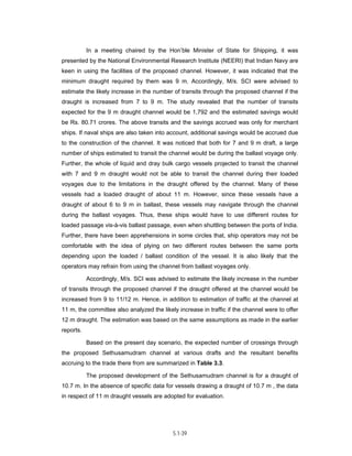
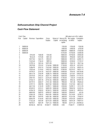
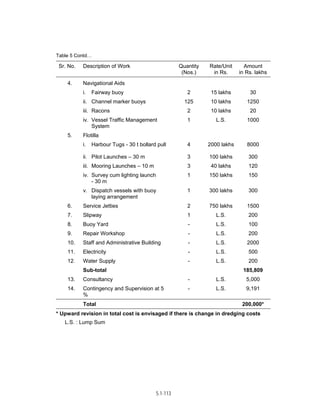
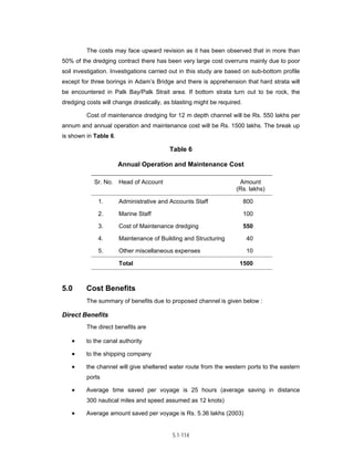
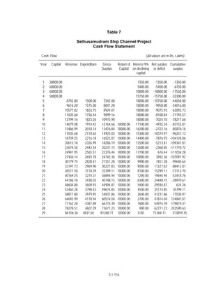
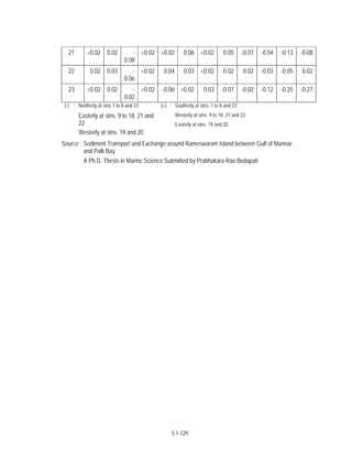
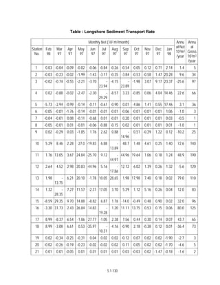
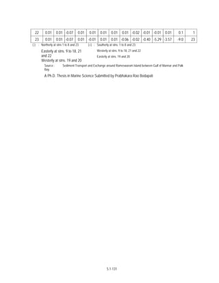
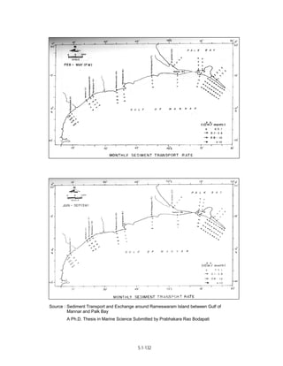
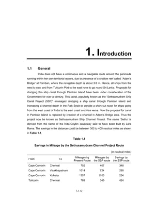
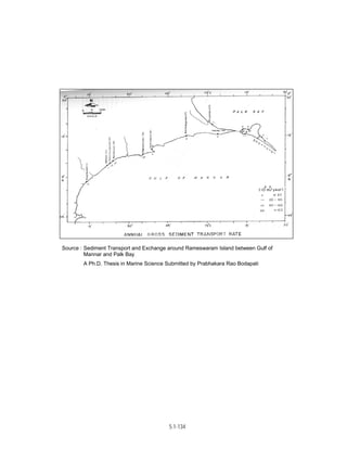
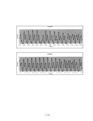
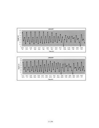
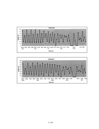
This document provides an executive summary of a technical feasibility and economic analysis report on the proposed Sethusamudram Channel project. It includes sections on earlier proposals for the channel, traffic analysis, proposed channel alignment and characteristics, cost estimates, cost-benefit analysis, and an economic viability evaluation. The analysis finds that the project is technically feasible and economically viable based on potential travel time and cost savings for shipping traffic transiting between India's east and west coasts.
Design Manual Guidelines for the King Abdullah Financial District in Riyadh, Saudi Arabia. As part of a team, I was responsible for finalizing the guidelines, writing new sections, re-writing older sections and supplying all graphics needed for the guidelines.
The Guidelines on the Incident Response System (IRS) are issued by the
National Disaster Management Authority (NDMA) under Section 6 of the
DM Act, 2005 for effective, efficient and comprehensive management of
disasters in India. The vision is to minimize loss of life and property by
strengthening and standardising the disaster response mechanism in the
country.
Though India has been successfully managing disasters in the past,
there are still a number of shortcomings which need to be addressed. The
response today has to be far more comprehensive, effective, swift and well
planned based on a well conceived response mechanism.
Realisation of certain shortcomings in our response system and a desire
to address the critical gaps led the Government of India (GoI) to look at
the world’s best practices. The GoI found that the system evolved for firefighting
in California is very comprehensive and thus decided to adopt
Incident Command System (ICS).
In view of the provisions of the DM Act, 2005, NDMA felt that authoritative
Guidelines on the subject, with necessary modifications to suit the Indian
administrative setup, were essential. To meet this need, a core group of
experts was constituted and four regional consultation workshops were
conducted. It was ensured that representatives of the State Governments
and MHA participate and their views given due consideration. Training
Institutes like the LBSNAA, NIDM and various RTIs / ATIs along with National
core trainers also participated. The adaptation of ICS by other countries
was also examined. The draft prepared was again sent to all States, UTs and
their final comments were obtained and incorporated. A comprehensive set
of Guidelines has thus been prepared and is called the Incident Response
System (IRS)
The final version of drilling regulations that will allow shale gas drilling on land protected by the Delaware River Basin Commission. These rules are the culimination of several years of research and hearings by the DRBC.
Mr. Jun Chang presentation was entitled “Meeting Long-Term Water Demands for Houston and Surrounding Areas.” Mr. Chang is a Deputy Director, Public Works & Engineering Department at the City of Houston.
Environmental Impact Assessment(EIA) is a process which ensures that all environmental matters are taken into account quite early in the project at planning process itself.It takes into consideration not only technical and economic considerations but also, traditional aspects like impact on local people, biodiversity etc.
The Department of Environment has approved this faulty EIA submitted by the Power Development Board. The project would be implemented by the governments of Bangladesh and India.
Issue Date: Apr-2000
Type: Thesis
Publisher: Asian Institute of Technology
Abstract: The element-free Galerkin method (EFGM) is a recently developed numerical technique for solving problems in a wide range of application areas including solid and fluid mechanics. The primary benefit of these methods is the elimination of the need for meshing (or remeshing) complex three-dimensional problem domains. With EFGM, the discrete model of the object is completely described by nodes and a description of the problem domain boundary. However, the elimination of meshing difficulties does not come freely since the EFGM is much more computationally expensive than the finite element method (FEM), especially for three-dimensional and non-linear applications. Parallel processing has long been an available technique to improve the performance of scientific computing programs, including the finite element method. With efficient programming, parallel processing can overcome the high computing time that is typically required in analyses employing EFGM or other meshless methods. This work focuses on the application of the concepts in parallel processing to EFGM analyses, particularly in the formulation of the stiffness matrix, the assembly of the system of discrete equations, and the solution for nodal unknowns, so that the time required for EFGM analyses is reduced. Several low-cost personal computers are joined together to form a parallel computer with the potential for raw computing power comparable to that of the fastest serial computers. The processors communicate via a local high-speed network using the Message Passing Interface (MPI), a standard library of functions that enables parallel programs to be executed on and communicate efficiently over a variety of machines. To provide a comparison between the parallelized and the serial versions of the EFGM computer program, several benchmark 3D structural mechanics problems are analyzed to show that the parallelized EFGM program can provide substantially shorter run time than the serial program without loss of solution accuracy.
URI: http://dspace.siu.ac.th/handle/1532/134
Observability Concepts EVERY Developer Should Know -- DeveloperWeek Europe.pdfPaige Cruz
Monitoring and observability aren’t traditionally found in software curriculums and many of us cobble this knowledge together from whatever vendor or ecosystem we were first introduced to and whatever is a part of your current company’s observability stack.
While the dev and ops silo continues to crumble….many organizations still relegate monitoring & observability as the purview of ops, infra and SRE teams. This is a mistake - achieving a highly observable system requires collaboration up and down the stack.
I, a former op, would like to extend an invitation to all application developers to join the observability party will share these foundational concepts to build on:
zkStudyClub - Reef: Fast Succinct Non-Interactive Zero-Knowledge Regex ProofsAlex Pruden
This paper presents Reef, a system for generating publicly verifiable succinct non-interactive zero-knowledge proofs that a committed document matches or does not match a regular expression. We describe applications such as proving the strength of passwords, the provenance of email despite redactions, the validity of oblivious DNS queries, and the existence of mutations in DNA. Reef supports the Perl Compatible Regular Expression syntax, including wildcards, alternation, ranges, capture groups, Kleene star, negations, and lookarounds. Reef introduces a new type of automata, Skipping Alternating Finite Automata (SAFA), that skips irrelevant parts of a document when producing proofs without undermining soundness, and instantiates SAFA with a lookup argument. Our experimental evaluation confirms that Reef can generate proofs for documents with 32M characters; the proofs are small and cheap to verify (under a second).
Paper: https://eprint.iacr.org/2023/1886
In the rapidly evolving landscape of technologies, XML continues to play a vital role in structuring, storing, and transporting data across diverse systems. The recent advancements in artificial intelligence (AI) present new methodologies for enhancing XML development workflows, introducing efficiency, automation, and intelligent capabilities. This presentation will outline the scope and perspective of utilizing AI in XML development. The potential benefits and the possible pitfalls will be highlighted, providing a balanced view of the subject.
We will explore the capabilities of AI in understanding XML markup languages and autonomously creating structured XML content. Additionally, we will examine the capacity of AI to enrich plain text with appropriate XML markup. Practical examples and methodological guidelines will be provided to elucidate how AI can be effectively prompted to interpret and generate accurate XML markup.
Further emphasis will be placed on the role of AI in developing XSLT, or schemas such as XSD and Schematron. We will address the techniques and strategies adopted to create prompts for generating code, explaining code, or refactoring the code, and the results achieved.
The discussion will extend to how AI can be used to transform XML content. In particular, the focus will be on the use of AI XPath extension functions in XSLT, Schematron, Schematron Quick Fixes, or for XML content refactoring.
The presentation aims to deliver a comprehensive overview of AI usage in XML development, providing attendees with the necessary knowledge to make informed decisions. Whether you’re at the early stages of adopting AI or considering integrating it in advanced XML development, this presentation will cover all levels of expertise.
By highlighting the potential advantages and challenges of integrating AI with XML development tools and languages, the presentation seeks to inspire thoughtful conversation around the future of XML development. We’ll not only delve into the technical aspects of AI-powered XML development but also discuss practical implications and possible future directions.
Pushing the limits of ePRTC: 100ns holdover for 100 daysAdtran
At WSTS 2024, Alon Stern explored the topic of parametric holdover and explained how recent research findings can be implemented in real-world PNT networks to achieve 100 nanoseconds of accuracy for up to 100 days.
Enchancing adoption of Open Source Libraries. A case study on Albumentations.AIVladimir Iglovikov, Ph.D.
Presented by Vladimir Iglovikov:
- https://www.linkedin.com/in/iglovikov/
- https://x.com/viglovikov
- https://www.instagram.com/ternaus/
This presentation delves into the journey of Albumentations.ai, a highly successful open-source library for data augmentation.
Created out of a necessity for superior performance in Kaggle competitions, Albumentations has grown to become a widely used tool among data scientists and machine learning practitioners.
This case study covers various aspects, including:
People: The contributors and community that have supported Albumentations.
Metrics: The success indicators such as downloads, daily active users, GitHub stars, and financial contributions.
Challenges: The hurdles in monetizing open-source projects and measuring user engagement.
Development Practices: Best practices for creating, maintaining, and scaling open-source libraries, including code hygiene, CI/CD, and fast iteration.
Community Building: Strategies for making adoption easy, iterating quickly, and fostering a vibrant, engaged community.
Marketing: Both online and offline marketing tactics, focusing on real, impactful interactions and collaborations.
Mental Health: Maintaining balance and not feeling pressured by user demands.
Key insights include the importance of automation, making the adoption process seamless, and leveraging offline interactions for marketing. The presentation also emphasizes the need for continuous small improvements and building a friendly, inclusive community that contributes to the project's growth.
Vladimir Iglovikov brings his extensive experience as a Kaggle Grandmaster, ex-Staff ML Engineer at Lyft, sharing valuable lessons and practical advice for anyone looking to enhance the adoption of their open-source projects.
Explore more about Albumentations and join the community at:
GitHub: https://github.com/albumentations-team/albumentations
Website: https://albumentations.ai/
LinkedIn: https://www.linkedin.com/company/100504475
Twitter: https://x.com/albumentations
UiPath Test Automation using UiPath Test Suite series, part 5DianaGray10
Welcome to UiPath Test Automation using UiPath Test Suite series part 5. In this session, we will cover CI/CD with devops.
Topics covered:
CI/CD with in UiPath
End-to-end overview of CI/CD pipeline with Azure devops
Speaker:
Lyndsey Byblow, Test Suite Sales Engineer @ UiPath, Inc.
Dr. Sean Tan, Head of Data Science, Changi Airport Group
Discover how Changi Airport Group (CAG) leverages graph technologies and generative AI to revolutionize their search capabilities. This session delves into the unique search needs of CAG’s diverse passengers and customers, showcasing how graph data structures enhance the accuracy and relevance of AI-generated search results, mitigating the risk of “hallucinations” and improving the overall customer journey.
Securing your Kubernetes cluster_ a step-by-step guide to success !KatiaHIMEUR1
Today, after several years of existence, an extremely active community and an ultra-dynamic ecosystem, Kubernetes has established itself as the de facto standard in container orchestration. Thanks to a wide range of managed services, it has never been so easy to set up a ready-to-use Kubernetes cluster.
However, this ease of use means that the subject of security in Kubernetes is often left for later, or even neglected. This exposes companies to significant risks.
In this talk, I'll show you step-by-step how to secure your Kubernetes cluster for greater peace of mind and reliability.
In his public lecture, Christian Timmerer provides insights into the fascinating history of video streaming, starting from its humble beginnings before YouTube to the groundbreaking technologies that now dominate platforms like Netflix and ORF ON. Timmerer also presents provocative contributions of his own that have significantly influenced the industry. He concludes by looking at future challenges and invites the audience to join in a discussion.
Sudheer Mechineni, Head of Application Frameworks, Standard Chartered Bank
Discover how Standard Chartered Bank harnessed the power of Neo4j to transform complex data access challenges into a dynamic, scalable graph database solution. This keynote will cover their journey from initial adoption to deploying a fully automated, enterprise-grade causal cluster, highlighting key strategies for modelling organisational changes and ensuring robust disaster recovery. Learn how these innovations have not only enhanced Standard Chartered Bank’s data infrastructure but also positioned them as pioneers in the banking sector’s adoption of graph technology.
LF Energy Webinar: Electrical Grid Modelling and Simulation Through PowSyBl -...DanBrown980551
Do you want to learn how to model and simulate an electrical network from scratch in under an hour?
Then welcome to this PowSyBl workshop, hosted by Rte, the French Transmission System Operator (TSO)!
During the webinar, you will discover the PowSyBl ecosystem as well as handle and study an electrical network through an interactive Python notebook.
PowSyBl is an open source project hosted by LF Energy, which offers a comprehensive set of features for electrical grid modelling and simulation. Among other advanced features, PowSyBl provides:
- A fully editable and extendable library for grid component modelling;
- Visualization tools to display your network;
- Grid simulation tools, such as power flows, security analyses (with or without remedial actions) and sensitivity analyses;
The framework is mostly written in Java, with a Python binding so that Python developers can access PowSyBl functionalities as well.
What you will learn during the webinar:
- For beginners: discover PowSyBl's functionalities through a quick general presentation and the notebook, without needing any expert coding skills;
- For advanced developers: master the skills to efficiently apply PowSyBl functionalities to your real-world scenarios.
Alt. GDG Cloud Southlake #33: Boule & Rebala: Effective AppSec in SDLC using ...James Anderson
Effective Application Security in Software Delivery lifecycle using Deployment Firewall and DBOM
The modern software delivery process (or the CI/CD process) includes many tools, distributed teams, open-source code, and cloud platforms. Constant focus on speed to release software to market, along with the traditional slow and manual security checks has caused gaps in continuous security as an important piece in the software supply chain. Today organizations feel more susceptible to external and internal cyber threats due to the vast attack surface in their applications supply chain and the lack of end-to-end governance and risk management.
The software team must secure its software delivery process to avoid vulnerability and security breaches. This needs to be achieved with existing tool chains and without extensive rework of the delivery processes. This talk will present strategies and techniques for providing visibility into the true risk of the existing vulnerabilities, preventing the introduction of security issues in the software, resolving vulnerabilities in production environments quickly, and capturing the deployment bill of materials (DBOM).
Speakers:
Bob Boule
Robert Boule is a technology enthusiast with PASSION for technology and making things work along with a knack for helping others understand how things work. He comes with around 20 years of solution engineering experience in application security, software continuous delivery, and SaaS platforms. He is known for his dynamic presentations in CI/CD and application security integrated in software delivery lifecycle.
Gopinath Rebala
Gopinath Rebala is the CTO of OpsMx, where he has overall responsibility for the machine learning and data processing architectures for Secure Software Delivery. Gopi also has a strong connection with our customers, leading design and architecture for strategic implementations. Gopi is a frequent speaker and well-known leader in continuous delivery and integrating security into software delivery.
Alt. GDG Cloud Southlake #33: Boule & Rebala: Effective AppSec in SDLC using ...
Techno-economic feasibility report (SSCP) Aug. 2004
1. Technical Feasibility and Economic Analysis of
Proposed Sethusamudram Channel
(Executive Summary)
Sponsor :
Tuticorin Port Trust, Tuticorin
National Environmental Engineering Research Institute
Nehru Marg, Nagpur- 440 020
3. Technical Feasibility and Economic Analysis of
Proposed Sethusamudram Channel
Sponsor :
Tuticorin Port Trust, Tuticorin
National Environmental Engineering Research Institute
Nehru Marg, Nagpur- 440 020
5.1-2
4. July 2004
Contents
Index No. Title Page
No.
List of Figures (iv)
List of Tables (v)
List of Annexures (vi)
Executive Summary i-
xxi
1.0 Introduction 1.1-
1.5
1.1 General 1.1
1.2 Economy of Sea Transport 1.2
1.3 Pre-Independence Proposals 1.3
1.4 Post Independence Proposal 1.3
1.5 Present Proposal 1.3
2.0 Earlier Proposals 2.1-
2.18
2.1 General 2.1
2.2 Pre Independence Proposals 2.1
2.2.1 History of Earlier Proposals 2.2
2.2.2.1 Proposal-1 2.2
2.2.2.2 Proposal-2 2.3
2.2.2.3 Proposal-3 2.3
2.2.2.4 Proposal-4 2.3
2.2.2.5 Proposal-5 2.3
2.2.2.6 Proposal-6 2.3
2.2.2.7 Proposal-7 2.4
2.2.2.8 Proposal-8 2.4
2.2.2.9 Proposal-9 2.4
2.3 Post Independence Proposals 2.7
2.4 Traffic Projections 2.9
2.5 Canal Alignment 2.9
2.6 Economic Evaluation
2.11
2.7 Cost Benefit
2.11
2.8 Indirect Benefits
2.11
5.1-3
5. Figure 2.1-2.2 2.13-
2.14
Tables 2.1-2.4 2.15-
2.18
3.0 Traffic Analysis 3.1-
3.16
3.1 Design Draft for Sethusamudram Ship Channel Project 3.1
3.2 Past Traffic Surveys 3.2
3.3 Traffic Projections by Shipping Corporation of India (SCI) 3.2
3.4 Traffic Projections for the Present Study 3.4
3.5 Conclusion 3.5
Annexure 3.1 3.6
5.1-4
6. Index No. Title Page
No.
4.0 Channel Alignment and Characteristics 4.1-
4.9
4.1 General 4.1
4.2 Channel Alignment 4.1
4.2.1 Alignment in the Adam's Bridge Area 4.2
4.2.2 Alignment in Palk Bay and Palk Strait 4.2
4.3 Design Vessel Dimensions for the Sethusamudram
Ship Channel Project 4.3
4.4 Channel Width 4.4
4.5 Channel Depth 4.6
4.6 Conclusions 4.7
Figures 4.1-4.2 4.8-
4.9
Charts 4.1-4.12 Vol.
II
5.0 Cost Estimates 5.1-
5.31
5.1 General 5.1
5.1.1 Dredging 5.1
5.1.1.1 Methodology of Dredging 5.1
5.1.2 Rate Analysis for Dredging 5.4
5.1.3 Navigational Aids 5.9
5.1.4 Other Items
5.11
5.2 Capital Cost
5.12
5.3 Phasing of Capital Expenditure
5.12
5.4 Source of Funds
5.12
5.5 Operation and Maintenance Cost
5.12
Table 5.1-5.2 5.14-
5.17
Annexure 5.1 5.18-
5.31 Charts 5.1-5.2 Vol.
II
5.1-5
7. 6.0 Cost Benefits 6.1-
6.3
6.1 General 6.1
6.2 Benefits from Sethusamudram Ship Channel 6.1
6.2.1 Direct Benefits 6.2
6.2.2 Indirect Benefits 6.2
7.0 Economic Viability 7.1-
7.8
7.1 Economic Evaluation 7.1
7.2 Methods of Evaluation 7.1
7.2.1 Net Present Value (NPV) 7.1
7.2.2 Internal Rate of Return (IRR) 7.2
7.2.3 Benefit / Cost Ratio (B/C Ratio) 7.2
7.2.4 Average Rate of Return 7.2
7.2.5 Pay Back Period 7.2
7.2.6 Selection of the Method 7.2
5.1-6
8. Index No. Title Page
No.
7.3 Cost Estimates 7.2
7.3.1 Capital Costs 7.2
7.3.2 Operation and Maintenance Costs 7.3
7.4 Cost Benefits 7.3
7.4.1 Traffic Projections 7.3
7.4.2 Fixation of Channel Dues 7.3
7.5 Results of Economic Analysis 7.4
Annexures 7.1-7.4 7.5-
7.8
8.0 Conclusion 8.1-
8.2
Report on Sea State for Sethusamudram Ship
Annexure I
Channel Project I.1-
I.83
Annexure II Report on Tidal Information II.1-
II.65
Annexure III Literature Review III.1-
III.18
5.1-7
9. List of Figures
Figure No. Title Page
No.
1.1 Index Plan of Proposed Sethusamudram Ship Channel 1.5
1.2 Bathymetry along the Proposed Channel 1.6
2.1 Alignment of Sethusamudram Ship Canal (Earlier Proposal) 2.13
2.2 Various Alignments of Sethusamudram Ship Channel Project
Including the Proposed Alignment 2.14
4.1 The Alignment of the Proposed Channel 4.8
4.2 Cross Section of Proposed Channel 4.9
5.1-8
10. List of Tables
Table No. Title Page
No.
1.1 Savings in Mileage by the Sethusamudram Channel Project Route
1.
1
1.2 Typical Comparison of Modal Costs
1.
2
2.1 Sethusamudram Ship Canal Project – Traffic Projections
2.
15
2.2 Lengths of Various Segments of the Sethusamudram Ship Canal
2.
15
Estimated Quantities of Dredging and Costs for ′K′
2.3
(Kodandaramaswamy Koil) Alignment for Various Drafts
2.
16
2.4 Sethusamudram Ship Canal Project Components and Cost Estimates
2.
17
3.1 Draughts Considered under Various Proposals
3.
1
3.2 Past traffic Projections
3.
2
3.3 Expected Number of Transits through
Sethusamudram Channel
3.
4
4.1 Design Vessel Dimensions
4.
4
5.1-9
11. 5.1 Capital Cost for 10 m Depth and 300 m Width Channel
5.
14
5.2 Capital Cost for 12 m Depth and 300 m Width Channel
5.
16
7.1 Phasing of Expenditure
7.
3
5.1-10
12. List of Annexures
Annexure No. Title Page
No.
3.1 Estimation of Traffic Potential at the Channel at a
Proposed Draught of 11 and 12 m 3.6
5.1 Drilling Operations for Sub-Surface
Data at Sethusamudram Navigation Channel 5.18
7.1 IPR and NPV Appraisal with Revenue and Expenditure Constant 7.5
7.2 IPR and NPV Appraisal with Revenue and
Expenditure Increase by 5% 7.6
7.3 IPR and NPV Appraisal with Revenue and Expenditure
Increase by 10% and 5% respectively 7.7
7.4 Cash Flow Statement 7.8
I Report on Sea State for Sethusamudram Ship
Channel Project I.1-
I.83
II Report on Tidal Information II.1-
II.65
III Literature Review III.1-
III.18
5.1-11
13. 1. Introduction
1.1 General
India does not have a continuous and a navigable route around the peninsula
running within her own territorial waters, due to presence of a shallow reef called “Adam’s
Bridge” at Pamban, where the navigable depth is about 3.0 m. Hence, all ships from the
west to east and from Tuticorin Port to the east have to go round Sri Lanka. Proposals for
dredging this ship canal through Pamban Island have been under consideration of the
Government for over a century. This canal, popularly known as the “Sethsamudram Ship
Canal Project (SSP)” envisaged dredging a ship canal through Pamban island and
increasing a channel depth in the Palk Strait to provide a short cut route for ships going
from the west coast of India to the east coast and visa versa. Now the proposal for canal
in Pamban Island is replaced by creation of a channel in Adam’s Bridge area. Thus the
project now be known as Sethusamudram Ship Channel Project. The name ‘Sethu’ is
derived from the name of the Indo-Ceylon causeway said to have been built by Lord
Rama. The savings in the distance could be between 300 to 400 nautical miles as shown
in Table 1.1.
Table 1.1
Savings in Mileage by the Sethusamudram Channel Project Route
(in nautical miles)
Mileages by Mileages by Savings by
From To
Present Route the SSP route the SSP route
Cape Comorin Chennai 755 407 348
Cape Comorin Visakhapatnam 1014 724 290
Cape Comorin Kolkata 1357 1103 254
Tuticorin Chennai 769 345 424
5.1-12
14. Tuticorin Visakhapatnam 1028 662 366
Tuticorin Kolkata 1371 1041 330
1.2 Economy of Sea Transport
World over ports handle 82% of the worlds trade and hence its capacity and
efficiency will determine the growth and economic potential of the region or the country. In
India seaborne trade plays a vital role, as about 95% of the international trade takes place
through seaports. The approximate breakdown of cost in a typical transport chain is as
under
• Transportation to Port - 26%
• Port Handling (Loading) - 7%
• Sea Freight - 37%
• Port handling (Unloading) - 9%
• Transportation from Port - 21%
From the above, it may be seen that the sea freight constitutes an important
item in the cost of transport chain.
The cost per tonne of moving one tonne of coal by rail in India is about 54 ps. as
against 13 ps. by sea. (1996). Thus the movement by sea route costs only 25% of the rail
movement costs. Large quantities of coal move from Haldia / Paradeep to Tuticorin for
power generation. Sethusamudram Ship channel will give a big boost for this traffic.
Some of the international modal costs of various modes of transport for typical
commodities are presented in Table 1.2.
Table 1.2
Typical Comparison of Modal Costs
Mode Commodity & Route US Cents
per Tonne/Mile
Sea Iron Ore in Cape size vessels from Australia to Rotterdam 0.067
Air Australia to Europe 12.0
Rail Coal by rail in the USA 2.17
Source : Intercargo Annual Review 1996/97.
The above Table clearly illustrates the economy of sea transport compared to
other modes.
5.1-13
15. The proposed ship channel in Gulf of Mannar and Palk Bay area will save
about 20-25 hours of time which is around 20% of the average time for a ship movement
between Tuticorin and Haldia and will improve number of transits for transport of coal to
Tuticorin from Haldia Port. Thus already economic mode of transport can be further
economized due to this ship channel project.
The Sethusamudram ship channel will reduce the haulage distance by 424 nm
miles between Tuticorin and Chennai and about 366 nm between Tuticorin and
Visakhapatnam.
This channel system
• will also establish National waterway within territorial waters
• Reduce shipping distances
• Reduce voyage time
• Reduce operating costs and pave way for regional economic
developments.
1.3 Pre-Independence Proposals
Between 1890 and 1922 as many as nine proposals were formulated for
dredging a canal across the narrow strip of land mostly through the Rameshwaram Island
and the Gulf of Mannar with Palk Bay. However, the concerned authorities did not evince
much interest for the development of this project.
1.4 Post Independence Proposal
Between 1956 and 1996, five proposals were drawn up for the development of
the Sethusamudram Canal Project. The various proposals were
• Sethusamudram Project Committee (1956)
• Government of Madras (1960) which was revised in 1963
• Dr. Nagendra Singh Committee (1967)
• Shri H.R. Laxminarayan Committee (1983) (Fig. 1.1)
• M/s. Pallavan Transport Consultancy Services Ltd. (1996)
• NEERI report shifting canal alignment to Adams Bridge (1998)
1.5 Present Proposal
The Ministry of Shipping has identified Tuticorin Port Trust as the nodal agency
for the implementation of the Sethusamudram Ship Canal Project. In pursuance of its
5.1-14
16. decision to incorporate environmental considerations in the design phase of the project,
retained National Environmental Engineering Research Institute (NEERI), Nagpur to
conduct the Environmental Impact Assessment study for the project.
This report incorporates technical feasibility and economic analysis of proposed
Sethusamudram Ship Channel Project.
The present proposal envisages creation of a ship navigation channel to suit
different draughts viz. 9.15m, 10.7m and 12.8 m requiring dredging depths of 10 m, 12 m
and 14 m respectively. The width of the channel for 9.15 m and 10.7 m draught will be
300 m whereas for 12.8 m draught width will be 500 m. Based on the bathymetry survey
done by National Hydrographic Office (Fig. 1.2), it is observed that navigation depths in
Palk Bay area between Adams Bridge and Palk Strait are restricted to about 12 m only.
The total length from Adams Bridge to Palk Strait is about 145 km. In the event of
proposal for 12.8 m draught requiring 14 m depth, dredging will require to be carried out
in entire Palk Bay incurring heavy expenditure and additional dredge spoil generation of
about 170-180 million m3. Dredging in Palk Bay all along the channel length will be
detrimental to ecological sensitivity of Palk Bay. It would also entail incurrance of huge
additional expenditure for dredging & disposal of dredge spoil. Thus keeping in view
Environmental sensitivity and economic viability the proposal for 14 m depth (12.8 m
draught) is not evaluated.
The proposals are therefore evaluated only for 9.15 m and 10.7 m draught
requiring 10 and 12 m depth respectively.
Thus the proposed Sethusamudram Ship Channel Project is considered with
two dredged depth viz. of -10 mCD, -12 mCD to cater to vessels drawing a draught of
9.15 and 10.7 m respectively. The channel will have a bed width of 300 m providing a two
way channel for vessels drawing a draught of 9.15 and 10.7 m. The dredging of the
channel will be in
• Adam’s Bridge
• Parts of Palk Bay and
• Palk Strait
The navigation route will originate from Tuticorin Port in the Gulf of Mannar
utilizing the available depths which are about -20 mCD upto south east of Pambam
island, pass through a channel to be dredged to a depth of 10.0 m or -12 mCD in the
Adam’s Bridge within the international boundary and proceed parallel to the International
Medial Line in the Palk Bay, pass through a channel to be dredged to - 10 mCD or
5.1-15
17. -12 mCD in the Palk Strait and adjoining parts of Palk Bay and terminate in the Bay of
Bengal.
The basic difference between Sri. H.R. Laxminarayan Committee’s Report
(1983) and the present Report is that the creation of canal as a land locked body with a
Canal Lock which was proposed in the 1983 Report has been dispensed and creation of
channel in Gulf of Mannar and Palk Bay is proposed in the present report after a detailed
review.
5.1-16
18. 5.1-17
Savings by the
Mileages by Mileages by the
From To
Present Route SSP route SSP route
Cape Comorin Chennai 755 407 348
Cape Comorin Visakhapatnam 1014 724 290
Cape Comorin Kolkata 1357 1103 254
Tuticorin Chennai 769 345 424
Tuticorin Visakhapatnam 1028 662 366
Tuticorin Kolkata 1371 1041 330
Fig. 1.1 : Index Plan of Proposed Sethusamudram Ship Channel
19. 5.4 km
E4
14.4 km 10.5 m
E3
8.1 m
19.8 km E2
9.6 m
14.6 km
E1
E 11.6m
D
C
Km : Distance between points
m : average depth within a section
B
Fig. 1.2 : Bathymetry along the Proposed Channel
5.1-18
20. 2. Earlier Proposals
2.1 General
All the earlier project proposals were for creation of canal popularly known as
Sethusamudram Ship Canal Project and had been under the demand by the public,
statesmen, administrators and navigators for over a century. The phenomenal increase
in the traffic on land, steep hikes in the prices of the petroleum products had enhanced
the advantages and the economics of waterborne traffic.
2.2 Pre Independence Proposals
Between 1860 and 1922 as many as nine proposals were formulated for cutting
a canal across the narrow strip of land mostly through the Rameshwaram Island to
connect the Gulf of Mannar with Palk Bay with the object of providing a short cut for oean
going ships plying between the west and east coasts of India. The various proposals
were :
i. 1860 - Commander Taylor’s Proposal
ii. 1861 - Mr. Town Shed’s Proposal
iii. 1862 - Parliamentary Committee’s Proposal
iv. 1863 - His Excellency Sir William Dennison’s (Governor of Madras)
Proposal
v. 1871 - Mr. Stoddart’s Proposal
vi. 1872 - Mr. Robertson’s (Harbour Engineer to the Govt. of India) Proposal
vii. 1884 - Sir John Code’s Proposal
viii. 1903 - S.I Railway Engineers Proposal
ix. 1922 - Sir Robert Bristo’s (Harbour Engineer to the Govt. of India)
Proposal
5.1-19
21. A brief review of these proposals extracted from Shri C.V. Venkateshwaran’s
report.
2.2.1 History of Earlier Proposals
Between 1860 and 1922, as many as nine proposals were made for cutting a
Ship Channel across the narrow strip of land to connect the Gulf of Mannar and the Palk
Bay with the object of providing a short-cut for ocean-going ships plying between the
West Coast of India and the East Coast. These were :
1. 1860 Commander Taylor’s Proposal
2. 1861 Mr. Townshend’s Proposal
3. 1862 Parliamentary Committee’s Proposal
4. 1863 His Excellency Sir William dennison’s R.E. (Governor of Madras)
Proposal
5. 1871 Mr. Stoddart’s Proposal
6. 1872 Mr. Robertson’s (Harbour Engineer for India) Proposal
7. 1884 Sir John Code’s Proposal for South India Ship Canal, Port & Coaling
Station, Limited
8. 1903 S.I. Railway Engineer’s Proposal based on their Survey
9. 1922 Sir Robert Bristow’s (Harbour Engineer to the Government of Madras)
Proposal
These proposals are shown in Drawing No. 3
A brief survey of these various proposals extracted from Sir Bristow’s Report is
given hereunder :
2.2.1.1 Proposal-1
The earliest proposal for cutting a link canal was made in 1860 by Commander
Taylor of the Indian Marine. In his paper, he advocated cutting a canal across the
Tonitorai Peninsula at a place about 12 miles west of the Pamban Pass. He stated “The
southern end would start from ‘Port Lorne’, a natural harbour, a few miles down the coast
from Mandapam, about seven miles in length and four-and-a-half miles in breadth, the
grater part of which had a depth of 24 feet, and for some considerable extent up to 30
feet, the deepest parts being 36 feet. It was well sheltered by the Musal and Muli Islands
and reefs. Its entrance had only a depth of less than 15 feet, but if this were depend, it
would make the harbour a safe one for the anchorage of all vessels during the South-
West Monsoon”.
5.1-20
22. The Scheme involved the excavation of a deep cutting nearly three miles in
length through the dry land and deepening to five fathoms for at least three miles on each
side to connect it with the harbour on the south, and the deep water on the north. It would
also involve cutting a channel across the reef barrier at the southern entrance to the
harbour. It was at first stated to cost only about £ 90,000, but further inquiries brought the
estimate up to £ 1,500,000. The Northern approach would be exposed to the North-East
monsoon and would require special protective works. Owing to the great expense
involved and the extra work to be done in comparison with a canal across the Island of
Rameswaram (please see proposals 3 to 9), the Scheme was not seriously considered.
2.2.1.2 Proposal-2
The next proposal was by Mr. Townshend. He proposed siting the canal through
the Pamban Pass. His proposal was to deepen the existing tortuous Pamban Channel to
enable the passage of large vessels. However, the objections to its adoption, with a
curved channel, and subject to the strong currents through the Pamban Pass were so
obvious that it put the Scheme outside the pale of practical consideration.
2.2.1.3 Proposal-3
In 1862, a Parliamentary Committee of Her Majesty’s Government was
appointed to report on the site for a canal across the Island of Rameswaram, and they
recommended an alignment situated about two miles East of Pamban, crossing the Island
in a straight Northerly direction.
2.2.1.4 Proposal-4
In 1863, His Excellency Sir William Dennison, R.E., Acting Governor of Madras,
visited Pamban and selected a site which he considered the most advantageous. This
was about a mile further East from that recommended by the Parliamentary Committee.
Probably he visited the Island during the North-East monsoon, as he chose the best
position for a sheltered Northern approach at a time when the Northern seas were rough
and the Southern seas were calm. In the South-West monsoon, the Southern side will be
rough and the Northern side calm. This alignment was unsuitable, as its Southern
entrance would be very much exposed during the South-West monsoon.
2.2.1.5 Proposal-5
Subsequently in 1871, Mr. Stoddart recommended a site about one mile West of
Dennison’s alignment and parallel to it. This was practically the same as the one
suggested by the Parliamentary Committee. This alignment was protected by the reefs
5.1-21
23. and small islands on the Southern side from the South-West monsoon; its Northern
approach was, however, exposed to the North-East monsoon.
2.2.1.6 Proposal-6
In March, 1872, Sir Elphinstone, M.P., wrote to the Under Secretary of State for
India, requesting that “Mr. Robertson, Harbour Engineer for India, should be directed to
proceed to Pamban and examine the locality closely and minutely and give his opinion as
to the best mode of proceeding in the matter, which is every month becoming of greater
importance to the commerce and trade of the East”.
Mr. Robertson accordingly visited Pamban and selected a new site about a mile
from Pamban with its Southern entrance well within the protection of Kurisadi and Shingle
Islands leaving the Northern entrance quite unprotected from the North-East Monsoon as
he was of the opinion “that the point of paramount importance was the protection of the
Southern entrance from the swell of the South-West monsoon”. He did not evidently
make a close examination of the channel leading to the Southern entrance which would
be narrow and would require an enormous amount of dredging to fit it for the passage of
vessels.
2.2.1.7 Proposal-7
After a lapse of 12 years in the year 1884, “The South India Ship Canal Port and
Coaling Station, Limited,” U.K., considered the project for the construction of a canal
across the Rameswaram Island and instructed Sir John Code, Consulting Engineer, to
prepare a report and estimate. His report discussed the previous schemes and decided
on the best alignment for the canal. The southern entrance was just near that
recommended by Mr. Stoddart in 1871, but the placed his line of canal obliquely on land
so that the northern entrance would “derive considerable shelter from the northerly stretch
of the coast immediately to the eastward”. He states “there will be a further advantage
than the improved sheltering of the entrances, viz., the bringing of the course of vessels
passing through it more directly in the line of the winds both in the North-East and South-
West Monsoons. This I regard as a material consideration seeing that vessels of the
largest class which have their sides so high above the water will be much less liable to be
deflected from their true course while passing through the canal, owing to the wind being
almost invariably either ahead or astern, whichever monsoon might be blowing”.
The Secretary of State for India granted the South India Ship Canal Port and
Coaling Station, Limited, a perpetual concession, reserving the right to purchase the
canal under certain conditions. Correspondence between the Home and the Indian
5.1-22
24. Governments was carried on for some years. The Madras Government in their
proceeding, dated the 14th October 1890, however, advised the Government of India to
reject the scheme on the ground that the shoals at the Palk Straits between Pt. Calimere
and Pt. Pedro would prevent the projected canal being made use of by vessels of a deep-
sea draft. Apparently, the Madras Government Adviser had not studied the Ceylon
Government chart of the channel north of Ceylon, which showed ample waterway. The
present Drawing No. 2, in which soundings taken from the Admiralty Chart Nos. 68-A and
2197 are plotted would also show that there is a minimum depth of 33 to 34 feet by the
route via the Pedro Channel. In this drawing, this channel route is also marked for easy
reference.
Another point worth mentioning here is that in those days dredging and
deepening a channel in the open sea conditions in the Palk Straits where they may get
fiver or six feet waves in fair weather, could not be thought of, as dredgers could work
only in two or three feet waves. Now Dredger design has advanced considerably and
swell-compensating arrangements are provided in Trailer Suction Dredgers, so that it is
possible to dredge in 7 ft. or 8 ft. waves without any difficulty. In this connection, mention
may be made of the new estuarian dredger “Mohana” acquired for Calcutta Port to
dredge in the estuary in the exposed open sea conditions.
2.2.1.8 Proposal-8
In 1902, the South Indian Railway Company carried out a fresh survey by their
Engineers and decided upon an alignment in Rameswaram about which they stated as
follows :
″The final alignment of the canal has been determined after a careful survey
was made of the seas on each side, and due consideration was given to its protection at
both ends during the monsoons. A glance at the maps which accompany the project
report will show that the minimum amount of dredging at the approaches will be required
to enable a depth of 30 ft. to be dredged. The southern entrance is well under the
protection of the Kallaru reef with the Shingle Islets and also of the Kurisadi, Pulli-Vausel
and Pulli Islands and their surrounding reefs which form a natural breakwater during the
South-West monsoon″.
″The line of canal is oblique (and in the direction of the prevailing winds) and
has the same advantage as advocated by Sir John Code in his alignment, which has
already been referred to″.
5.1-23
25. ″No other alignment can be made for a canal which would offer the same
advantages having reference to the eligibility of the approaches and shelter which the
present one affords″.
2.2.1.9 Proposal-9
After another two decades, Sir Robert Bristow, Harbour Engineer to the
Government of Madras, made a thorough study of all the previous proposals and carried
out detailed investigations and put up his proposal for an alignment somewhat similar to
the previous one adopted by the S.I. Railway across the Rameswaram Island, as being
the best line for the canal crossing. He, however, shifted the southern extremity of the
land canal by about 500 yards west in order to get still better protection for the southern
approach.
Sir Robert Bristow in his report has stated that the reason for reopening the
matter at this date (1922) was that ″One of the reasons which was acting adversely to the
development of the ports of the South-East India was the fact that there was no deep-sea
passage northward of Cape Comorin and that nearly all traffic had to pass round the
Island of Ceylon. The question was, therefore, raised as to the advisability of cutting a
canal through the Island of Rameswaram, in order to remove this disability. A good deal
of discussion was aroused by this proposal, especially among the people of Tuticorin,
who, whilst in entire agreement with the idea of making a canal ‘qual canal’, were
apprehensive that, as it would cross the main line of railway from Dhanushkodi to
Madras, a port might grow up there, which would attract the trade from Tuticorin to
Rameswaram.
Again to quote from the Report of the Tuticorin Ad hoc Committee which
considered the Canal Scheme drawn up by Sir Robert Bristow :
″There has been very little of divergence of opinion during the discussions as to
the advantage of the canal in the abstract. Indeed, its obvious usefulness and the
desirability in the constructing it, if only on the broad ground of reducing ocean distances,
has made anything like serious discussion impossible. For example, it reduces the
distance from off Cape Comorin (a common point for all traffic from the West) to Madras,
Calcutta and Rangoon by 333, 240 and 109 miles, respectively and from Trincomalee to
Cape Comorin by 125 miles″.
″Further the actual saving in mileage and money is enhanced by the less
tangible, but, perhaps, more important savings consequent upon avoiding the stormy
journey round the Island of Ceylon particularly in monsoon weather. The increased wear
5.1-24
26. on all parts of the ship, and the anxiety and risk which are thus eliminated in the case of
all vessels render the construction of the canal a very desirable object on the general
grounds″.
This proposal, however, was not pursued then, apparently because of dearth of
finance.
2.3 Post Independence Proposals
The proposals considered after independence are as under :-
i) Sethusamudram Project Committee (1956)
The committee was headed by Sir A. Ramaswamy Mudaliyar and the committee
contemplated a 26 feet draft land canal crossing the main land at Mandapam
estimated to cost Rs.1.8 crores. Capt. H.R. Davis carried out further survey in
the year 1959 and suggested certain modifications, regarding alternative
alignment across the main land maintaining the same draft.
ii) The Government of Madras under the guidance of State Port Officer
explored the possibility of increasing the draft from 26 feet to 36 feet in the year
1963 at an estimated cost of Rs.21 crores.
iii) Government of India constituted a committee under the Chairmanship of
Dr. Nagendra Singh, Secretary Ministry of Shipping and Transport in the year
1964. Shri C.V. Venkateshwaran, Retd. Development Advisor, (Ports) was
appointed as the Chief Engineer to take up the investigation work. Shri R.
Natarajan was appointed as the Project Officer to collect the statistics of
shipping and to determine the economic viability of the project. The committee
completed its report in 1967 and the draft contemplated was 30 feet at an
estimated cost of Rs.37.46 crores. The committee examined both the
alignments suggested earlier and due to the presence of layers of sand stone in
the Madapam alignment, suggested an alternative alignment in the
Rameshwaram Island Crossing called the DE alignment near Thankachimadam.
The main components of the project involved were
- Excavation and dredging of the canal
- Construction of a lock
- Construction of a bridge
5.1-25
27. - Construction of breakwaters
- Procurement of a dredger and
- Land acquisition and procurement of harbour crafts, construction of
buildings, model studies etc.
iv) The committee under the Chairmanship of Shri H.R. Lakshminarayan
Development Advisor (Ports) was constituted in the year 1981. The committee
collected the opinions and representations of the leading public, industrialists
and Government officials of the State. All of them unanimously urged the
Government to take up the scheme immediately. The prominent citizens of the
Rameshwaram island represented that the canal would serve better if located to
the east of Rameshwaram town as far as possible, as it would otherwise affect
the movement of the pilgrims of the temple town. After detailed investigations a
new alignment was proposed across Dhanushkodi, 1km. west of
Kodandaramasamy Temple across the narrow land strip known as the ‘K’
alignment. The committee also appointed a Navigational Expert Group to
finalize the bottom width of the channel and the under keel clearance. The
committee recommended construction of two channels called the south and
north channels and also construction of a lock in the land portion connecting
both the channels.
The salient features of the scheme were as under :-
Length Dredging depth
Bottom width
Section of the Channel in nautical in meters chart
in meters
miles datum
Bay of Bengal channel 33.5 305 12.2
North approach 8.05 244 11.6
Lock in land canal 300m. 45 12.2
South approach 2.4 244 11.6
A side slope of 1:6 was considered.
The estimated cost of the project was Rs. 282 crores with a foreign exchange
component of Rs. 3 crores.
v) During 1994, the State Government of Tamil Nadu felt that Sri. H.R.
Laxminarayan Committee Report of 1983 has to be up dated and directed M/s.
Pallavan Transport Consultancy Services Ltd.(PTCS), a Govt. Tamil Nadu
5.1-26
28. undertaking, to reappraise and revalidate the 1983 report. Fresh particulars of
cost and traffic were collected and incorporated in the report.
PTCS Report Considered Following Project Components :
Apart from the construction of the proposed canal, which constitutes the major
component of the project, a number of infrastructural facilities as listed below are
envisaged to be created under the project :
• Construction of a ″lock″
• Construction of rubble mound type breakwaters on either side of the land canal
• Navigational aids
Lighted beacons/buoys
-
Racons
-
Satellite based differential global system
-
Improvements to Pamban light house
-
• Flotilla
Harbour tugs
-
Pilot, mooring, survey-cum-lighting launches
-
Despatch vessels
-
• Shore facilities
Two service jetties
-
Slipways
-
Buoy yard
-
Repair workshop
-
• Staff and administration buildings
2.4 Traffic Projections
The Lakshminarayan Committee in 1983 had made traffic projections for 30′
draft in the first stage by which time the harbours at Mangalore, Tuticorin, Vizag and
Paradeep had come into existence. Following a detailed analysis of traffic through other
Indian ports, projections have been made for the year 2000 AD (Table 2.1) while
updating the report by the PTCS Ltd. The minimum depth available in Chennai,
Vishakhapatnam and Paradeep in inner harbour is 18.6, 10.7 and 12.8 m respectively
whereas depth available in outer harbour is 19.2 and 17.5 m at Chennai and
Vishakhapatnam respectively.
2.5 Canal Alignment
5.1-27
29. The canal proposed earlier (Fig. 2.1) had two legs, one near the Point Calimere
which is called the Bay of Bengal Channel and another across the narrow Danushkody
Peninsula near Kodandaramasamy Temple. The lengths of various segments of the canal
for the different drafts are shown in Table 2.2. The Bay of Bengal Channel traverses the
Palk Bay wherein the sea-bed is mostly soft to hard clayey-sand in nature. Bore holes
drilled into the sea-bed upto 15 m depth met with only clay and not corals or rock. The
canal is 19.3 km away from Point Calimere and Kanakesan Thurai where the coast
consists of only clayey-sand. The second leg of the canal 802 m long crosses the narrow
Danushkody Peninsula through the land portion. The entire coast of Danushkody
Peninsula on the North and the South is all sandy. Drillings done at 16 places here have
shown only sandy strata upto 12 depth. In the North Approach Channel, soft sand-stone
was met with below 12 m depth and cutting this sand-stone is not necessary even in the
ultimate stage of the canal. The canal will, however, cut the road connecting
Rameswaram and Danushkody. This road is being used by the Rameswaram fisherman
to go to Danushkody for daily fishing as there is no habitation at Danushkody. The project
envisages a high-level or a swinging bridge at the crossing point to enable the traffic to go
through.
Tracer studies at two places along the 'K' alignment conducted jointly by the
Atomic Energy Establishment and the Central Water and Power Research Station in two
monsoon seasons established that the pattern of movement of sea-bed silt would almost
be in the same direction as that of the proposed channel, and that the chances of siltation
would be very minimal.
Cost Estimates
The cost estimates for the canal project were worked out by PTCS Ltd. based
on the same quantities of dredging as in the 1983 report but with updated rates for the
year 1994. The costs of dredging for the various segments of the channel of the project
for the three different drafts viz. 30, 31 and 35 feet are presented in Table 2.3. The
abstract of cost estimates for all the components of the project including those of
navigational aids and floating crafts is presented in Table 2.4. The construction period for
31 feet draft is estimated at four years and the phasing of the capital expenditure will be
as under :
Year Amoutn (Rs. in Crores)
30 ft. draft 31 ft. draft 35 ft. draft
First 120 120 160
5.1-28
30. Second 180 210 210
Third 180 210 210
Fourth 205 220 210
Fifth NIL NIL 210
Sixth NIL NIL 200
Total 685 760 1200
The operation and maintenance cost has been estimated by PTCS Ltd. at
Rs. 4.52 crores per year. It is expected that this cost will increase by about 5 % every
year. In case of 35 feet draft, the project period will stand extended by two more years.
2.6 Economic Evaluation
An economic appraisal of the Sethusamudram Ship Canal Project, taking into
account the cost estimates and the cost benefits of the proposal, has been made by
PTCS Ltd. Based on the Net Present Value (NPV) method of appraisal, an Internal Rate
of Return (IRR) of 10 to 17 % on the project investment has been arrived at. Considering
an interest rate of 9 % per annum on the capital employed on the basis of the rate of
Government lending to ports prevailing now, the project will start generating surplus from
the 16 to 17th year of its operation as per the cash flow statement The project will have a
cumulative surplus of over 1600 crores in 25th the year and over 3000 crores in the 30th
year. In the 25th year the CB ratio will be 1 and will increase by over 10% every year
reaching 1.75 in the 30th year.
2.7 Cost Benefit
As per the economic analysis by PTCS Ltd. the project will be able to pay back
the principal and interest in the 17th year and thereafter the benefits to the canal
company would be 47 crores in the first year, and this would go on creasing by 100 to
120 crores every year. In the 30th year of operation, the annual surplus to the company
would be over Rs. 550 crores. The project will reduce the oil import bill by over Rs. 40
crores in the initial years, and this would increase every year by atleast 4 %. The canal
will boost the coastal and foreign ship-traffic and establish Chennai and Tuticorin as
international nodal ports. The social benefits to the backward region of old
Ramanathapuram district wilt be immense.
2.8 Indirect Benefits
5.1-29
31. Presently, the Tamil Nadu Electricity Board which moves coal from mines in
North India by road and brings it to the port for onward shipment to Tuticorin, spends
54 paise per tonne kilometre on road and 13 paise per tonne kilometre by sea. For want
of a sea canal, many commodities like salt, fish, and caustic soda are now transported by
rail causing congestion and incurring high cost. Once the canal comes into being, aIl this
and more can take the sea-route. Further, the canal system will establish a national
waterway within the territorial waters of India, reduce distances, and voyage time.
Likewise, all coastal ships plying between the East and the West coasts can make
considerable profits on extra turn-arounds. The canal will be a great asset from national
defence and security points of view and also the coast guards who now have to go
around Sri Lanka. Benefit of shorter distance will encourage small entrepreneurs to
launch new ventures of coastal sea-traffic between ports on trade and commerce. There
are rich resources of fish and shrimps in the area and this can be exported to Japan and
U.S.A. through Rameswaram Port which will get strengthened once the canal comes into
being. This will relieve the distress of Ramanathapuram district which is one of the worst
drought-prone areas in the country, and save the Governments from taking annual
special alleviation measures. On the whole, the canal will come as a boon to the industrial
development of the Ramanathapuram, Sivagangai, Tuticorin and Virudhunagar districts of
Tamil Nadu, and the nation in general.
Thus the revised cost as worked out by M/s Pallavan Transport for 35′ draught
was Rs. 1200 Crores.
Various alignments of Sethusamudram Ship Channel Project proposed earlier
till NEERI's report of 1998 as also now proposed alignment is shown in Fig. 2.2.
5.1-30
33. 4
1 3
2 6
1 Proposed in 1961
2 Proposed in 1968
3 Proposed in 1996 Report
4 Suggested by Steering Committee
5 Considered by NEERI (1998)
6 Present Proposal of NEERI
5
5.1-32
LEGEND
Fathoms Line 3.5
Fathoms Line 5.0
Reefs
Fig. 2.2 : Various Alignments of Sethusamudram Ship Channel Project
Including the Proposed Alignment
34. Table 2.1
Sethusamudram Ship Canal Project – Traffic Projections
Draft 1983 Committee 1996 Report for 2000 AD
Transits NRT Transits NRT
Nos. % Lakh % Nos. % Lakh %
tones tones
upto 30' 2100 89.4 160 79.6 3791 90.0 319.6 82.2
31-32' 2200 93.6 170 84.0 3875 92.0 328.0 84.4
above 34' 2300 100.0 201.0 100.0 4211 100.0 388.5 100.0
Table 2.2
Lengths of Various Segments of the Sethusamudram Ship Canal
Item Length
30′draft 31′draft 35′draft
Nautical Nautical Nautical
Meter Meter Meter
Miles Miles Miles
Bay of Bengal Channel 33.5 61,700 39.2 72,300 56.0 1,00,800
Sea Lane (no dredging) 34.0 62,968 28.5 52,782 Nil Nil
North Approach Channel 7.39 13,600 10.89 20,065 19.8 36,564
Land canal upto lock 0.44 802 0.44 802 0.40 802
Lock 0.16 300 0.16 300 0.16 300
Land canal blow lock 0.60 1,117 0.60 1,117 0.60 1,117
South Approach Channel 2.06 3,800 2.31 4,250 4.00 7,200
5.1-33
35. Table 2.3
Estimated Quantities of Dredging and Costs for ′K′
(Kodandaramaswamy Koil) Alighment for Various Drafts
Sr. Description 30′ draft 31′ draft 35′ draft
No.
Length Width Quantity of Dredging Length Width Quantity of Dredging Length Width Quantity of Dredging
(m) (m) Dredging Cost (Rs. (m) (m) Dredging Cost (Rs. (m) (m) Dredging Cost (Rs.
Material in lakhs) Material in lakhs) Material in lakhs)
(lakh m3) (lakh m3) (lakh m3)
1. Bay of Bengal
61,700 305 375.60 30048.00 72.300 305 446.00 35680.00 1,00,800 305 832.20 66570.00
Channel
2. North
Approach 13.600 245 147.33 8827.00 20,065 245 165.41 9924.60 36,564 245 313.00 18780.00
Channel
3. South
Approach 3,800 245 29.33 1759.80 4.250 245 33.18 1990.80 7,200 245 55.10 3306.00
Channel
4. Land Canal
a) upto lock 802 245 69.86 6986.00 802 245 71.72 7172.00 802 245 76.65 7665.00
b) below lock 1,117 1.117 1,117
Mobilisation - - - 150.00 - - - 150.00 - - - 150.00
Total 81,019 622.12 47770.80 98,534 716.31 54917 .40 1,46,483 1276.95 96477 .00
5.1-34
36. Table 2.4
Sethusamudram Ship Canal Project Components and Cost Estimates
Sr. Description 30′ draft 31′ draft 35′ draft
No.
Quantity Rate Amount Quantity Rate (Rs.) Amount Quantity Rate Amount
(Rs.) (Rs. in (Rs. in (Rs.) (Rs. in
lakhs) lakhs) lakhs)
1. Preliminary expenses such as - - 500.00 L.S. - 500.00 L.S. - 500.00
model studies, hydrographic
and land surveys, soundings,
boring, consultancy fees etc.
at 20%
2. Land Acquisition charges L.S. - 50.00 40 125000/ 50.00 40 L.S. 50.00
including payment for hectares hectares hectares
compensation of structures for
40 hectares
3. Dredging and excavation :
Dredging the loose or compact
sand, silt or any other soft
materials from the existing sea
bed to the required levels by
suitable dredgers in the
proposed canal, conveying the
dredged spoils and dumping
the same at dumping site
including removal of
abstructions if any :
i) Mobilisation and LS - 150.00 LS - 150.00 LS - 150.00
demobilization charges
ii) South approach channel 29.33 60/m3 1759.80 33.18 60/m3 1990.00 50.10 60/m3 3306.00
(average lead 6 km) lakhs m3 lakhs m3 lakhs m2
iii) North approach channel 147.33 60/m3 8827.80 165.41 60/m3 9924.60 313.00 60/m3 18780.00
(average lead 6 km) lakhs m3 lakhs m3 lakhs m3
iv) Bay of Bengal channel 375.60 80/m3 30048.00 446.00 80/m3 35680.00 832.2 80/m3 66576.00
(average lead 15 km) m3 lakhs m3 lakhs m3
v) Land canal 69.86 m3 100/m3 6986.00 71.72 100/m3 7172.00 76.65 100/m3 7665.00
lakhs m3 lakhs m3
4. 4000.00 LS 4000.00 LS 4000.00
Construction of a ″lock″ of
size 300x45 m as per details
shown in the drawinings
5. Construction of Rubble Mound 1,60,000 274/t 438.00 1,60,000 274/t 438.40 1,60,000 274/t 438.00
Type Breakwaters of length tons tons tons
350 m each from shore to
–3 m depth on either side of
the land canal total 1400 km
5.1-35
37. Table 2.4 Contd…
Sr. Description 30′ draft 31′ draft 35′ draft
No.
Quantity Rate Amount Quantity Rate (Rs.) Amount Quantity Rate Amount
(Rs.) (Rs. in (Rs. in (Rs.) (Rs. in
lakhs) lakhs) lakhs)
6. Navigational Aids
i) Lighted beacons/buoys 35 Nos. 30 lakhs/ 1050.00 35 Nos. 30.00/ 1050.00 70 Nos. 30.00/ 2100.00
Nos. Nos. Nos.
ii) Racons 10 Nos. 12 lakhs/ 120.00 10 Nos. 12.00/ 120.00 15 Nos. 12.00/ 180.00
Nos. Nos. Nos.
iii) Satellite Based Differential 100.00 100.00 100.00
Global System
iv) Improvements to Pamban 100.00 100.00 100.00
light house
7. Flotilla
i) Harbour Tugs 30 TBP 4 Nos. 1540 6160.20 4 Nos. 1540 6160.20 4 Nos. 1540 6160.00
2700 HP (30 m x 10 m x lakhs/ lakhs/ lakhs/
3.5 m draught) Nos. Nos. Nos.
ii) Pilot launches 700 HP (22 3 Nos. 75 225.00 3 Nos. 75 225.00 3 Nos. 75 225.00
m x 5 m x 1.5 m to 2.0 m lakhs/ lakhs/ lakhs/
draught) Nos. Nos. Nos.
iii) Mooring launches -10 HP 3 Nos. 30 90.00 3 Nos. 30 90.00 3 Nos. 30 90.00
(10 m x 3.5 m x 1 m lakhs/ lakhs/ lakhs/
draught) Nos. Nos. Nos.
iv) Survey cum lighting 1 No. 100 100.00 1 No. 100 100.00 1 No. 100 100.00
launches 700 HP lakhs/ lakhs/ lakhs/
(25m x 7m x 2 m draught) Nos. Nos. Nos.
v) Despatch vessels – 2000 1 No. 100 100.00 1 No. 100 100.00 1 No. 100 100.00
HP (40 m x 12 m x 4 m lakhs/ lakhs/ lakhs/
draught) with buoy Nos. Nos. Nos.
servicing facilities
8. a) Provision of 2 service 300 km 4 1200.00 300 km 4 1200.00 3 km 4 1200.00
jetties 150 m long lakhs/km lakhs/km lakhs/km
b) Provision for slipway LS LS 100.00 LS LS 100.00 LS LS 100.00
c) Provision for buoy yard 1000 m2 1000/m2 45.00 1000 m2 1000/m2 45.00 1000 m2 1000/m2 45.00
d) Provision for repair 2000 m2 6000/m2 120.00 2000 m2 6000/m2 120.00 2000 m3 6000/m2 120.00
workshop
9. Staff & Administration Building LS LS 1000.00 LS LS 1000.00 LS LS 1000.00
10. Electricity at 7 1/12% on works 84.00 LS 84.00 LS 84.00
other than dredgers and jetties
11. Water supply at 7 ½ % on 84.00 LS 84.00 LS 84.00
works other than dredging and
jetties
12. Maintenance during 1808.00 LS 1808.00 LS 1808.00
construction
13. Petty supervision and 3253.40 LS 3608.20 4939.00
contingencies at 5%
Total 68500.00 76000.00 120000.00
5.1-36
38. 3. Traffic Analysis
3.1 Design Draft for Sethusamudram Ship Channel Project
Number of studies have been carried out earlier for the development of
Sethusamudram Ship Canal Project and the draughts considered under various
proposals are shown in Table 3.1.
Table 3.1
Draughts Considered under Various Proposals
Draft
Sr. No. Proposal
in feet (meters)
1 Sethusamudram Project Committee (1956) 26(7.93)
2 Government of Madras (1960) 26(7.93)
3. Government of Madras Revised (1962) 30 (9.15)
4. Dr. Nagendra Singh (1964-67) 30(9.15)
5. Mr. H.R. Laxminarayanan (1983) 30(9.15)
6. Pallavan Transport Consultancy Services Ltd., 30(9.15)
Chennai (1996) /35(10.7)
However, there has been a consistent trend in the increase in the size of
vessels and also for proposals for deepening of Haldia and Tuticorin. The Ports of
Visakhapatnam and Paradip have also been developed. Existing depths of inner harbour
at Chennai, Visakhapatnam and Paradeep are 18.6 m, 10.7m and 12.8 m respectively
whereas outer harbour depths at Chennai and Visakhapatnam are 19.2 m and 17.5 m
respectively. Taking into consideration the above as well as environmental sensitivity, it is
now proposed to assess traffic potential of Sethusamudram Ship Channels upto a depth
of 12 m (draught 10.7 m).
5.1-37
39. 3.2 Past Traffic Surveys
The various groups that considered the development of Sethusamudram Ship
Canal Project have projected different traffic at different points of time by adopting
different growth rates. The traffic projection in terms of transit and NRT by the various
committees is tabulated in Table 3.2.
Table 3.2
Past Traffic Projections
No. of Net Registered Tonnage
Sr. No. Proposal
Transits (NRT) (in lakh tonnes )
1. Sethusamudram Project 1613 64
Committee (1956)
Projection for 1961
2. Government of Madras (1960) 2212 93
3. Mr. K.N.Srinivasan (1963)
- Projection for 1968 1933 79
4. Mr.C.Venkateshwaran
Sethusamudram Project (1971) 102
5. Mr. R. Natarajan (1963) 2371 105
Projection for 1974 3300 150
6. Mr. H.R. Laxminarayan (1983)
Projection for 1980 2100 160
Projection for 1989-90 3000 230
7. Pallavan Transport Consultancy
Services Ltd., Chennai (1996)
Projection for 2000 (for 35 feet draft) 4211 388.5
3.3 Traffic Projections by Shipping Corporation of India (SCI)
SCI was advised by the Ministry of Shipping to examine the traffic potential that
is likely to transit through the Sethsamudram Channel for a draught of 7m. and the
resultant saving that would accrue to the shippers / consignees thereupon. It was
estimated that for an available draft of 7m. there would be about 1,708 transits through
the channel in a year and the industry would save about Rs. 68 crores by way of savings
in ship time and bunker consumption due to reduction in the navigable distance when
crossing from the East Coast to the West Coast of India and vice-versa.
5.1-38
40. In a meeting chaired by the Hon’ble Minister of State for Shipping, it was
presented by the National Environmental Research Institute (NEERI) that Indian Navy are
keen in using the facilities of the proposed channel. However, it was indicated that the
minimum draught required by them was 9 m. Accordingly, M/s. SCI were advised to
estimate the likely increase in the number of transits through the proposed channel if the
draught is increased from 7 to 9 m. The study revealed that the number of transits
expected for the 9 m draught channel would be 1,792 and the estimated savings would
be Rs. 80.71 crores. The above transits and the savings accrued was only for merchant
ships. If naval ships are also taken into account, additional savings would be accrued due
to the construction of the channel. It was noticed that both for 7 and 9 m draft, a large
number of ships estimated to transit the channel would be during the ballast voyage only.
Further, the whole of liquid and dray bulk cargo vessels projected to transit the channel
with 7 and 9 m draught would not be able to transit the channel during their loaded
voyages due to the limitations in the draught offered by the channel. Many of these
vessels had a loaded draught of about 11 m. However, since these vessels have a
draught of about 6 to 9 m in ballast, these vessels may navigate through the channel
during the ballast voyages. Thus, these ships would have to use different routes for
loaded passage vis-à-vis ballast passage, even when shuttling between the ports of India.
Further, there have been apprehensions in some circles that, ship operators may not be
comfortable with the idea of plying on two different routes between the same ports
depending upon the loaded / ballast condition of the vessel. It is also likely that the
operators may refrain from using the channel from ballast voyages only.
Accordingly, M/s. SCI was advised to estimate the likely increase in the number
of transits through the proposed channel if the draught offered at the channel would be
increased from 9 to 11/12 m. Hence, in addition to estimation of traffic at the channel at
11 m, the committee also analyzed the likely increase in traffic if the channel were to offer
12 m draught. The estimation was based on the same assumptions as made in the earlier
reports.
Based on the present day scenario, the expected number of crossings through
the proposed Sethusamudram channel at various drafts and the resultant benefits
accruing to the trade there from are summarized in Table 3.3.
The proposed development of the Sethusamudram channel is for a draught of
10.7 m. In the absence of specific data for vessels drawing a draught of 10.7 m , the data
in respect of 11 m draught vessels are adopted for evaluation.
5.1-39
41. A report prepared by Shipping Corporation of India on Traffic Potential for 11
and 12 m draughts is appended as Annexure 3.1.
5.1-40
42. Table 3.3
Expected Number of Transits through Sethusamudram Channel
Rs. in Crores
7m Draught 9m Draught 11 m Draught
Cargo
Transits Savings Transits Savings Transits Savings
(Per year) (Rs.) (Per year) (Rs.) (Per year) (Rs.)
POL & Specialized Cargo 282 39.39 366 51.97 522 75.75
Dry Bulk Cargo 120 11.92 120 11.92 120 11.92
General Cargo 1,306 16.82 1,306 16.82 1,362 19.81
1,708 68.13 1,792 80.71 2,004 107.48
Total
3.4 Traffic Projections for the Present Study
The traffic projections made by various committees is presented in Table 3.2.
A perusal of the figures indicate that there is a wide variations in the Projections. Further,
on the advise of Ministry of Shipping, M/s. Shipping Corporation of India was requested to
carry out a traffic projection for various drafts. The results are presented in Table 3.3.
This study is based on the present trade scenario.
The data presented by SCI relates to the ground reality today. The proposed
development of the Sethusamudram Ship Channel is for a maximum draught of 10.7 m.
In the absence of specific data for vessels drawing a draught of 10.7 m , the data in
respect of 11 m draught vessels viz. - 2004 Ship transits can be considered as a realistic
estimate.
However, the SCI study does not provide the data relating to NRT of ships.
The 1983 report contains the actual data relating to ship transits and NRT for
1980 viz.
• No. of ship transits 2100
• NRT 160 lakh tonnes
Since all the data available in earlier report is for NRT, from the above co-
relation the proportionate NRT for 2004 transits works out to 153 lakh tonnes. Hence, the
following traffic data is considered for evaluation.
• Number of ship transits 2004
5.1-41
43. • NRT 153 lakh tonnes
3.5 Conclusion
In view of large variations in the past traffic projections and the study now
carried out by SCI, it is proposed to consider the number of transits as per the SCI Study
which is based on the present trade scenario for the purpose of evaluation. However, the
SCI Study do not contain the NRT data. Hence, the co-relation between transits and NRT
as per the 1983 report has been considered.
Thus, the number of transits and the NRT considered for evaluation are
• Number of ship transits - 2004
• NRT - 153 lakh tons
5.1-42
44. Annexure 3.1
Sethusamudram Ship Channel
Supplementary Report – II
Estimation of Traffic Potential at the Channel at a
Proposed Draught of 11 and 12 m
(Report Prepared by Shipping Corporation of India, January 2003)
In respect of the proposed Sethusamudram Ship Canal Project, the SCI has
done an estimation on the traffic that is likely to transit through the proposed canal at a
draught of 7 metres as also 9 metres, and the resultant savings that would accrue to the
shippers/consignees thereupon due to reduction in the navigable distance when crossing
from the East Coast to the West Coast of India and vice-versa. It has been estimated
that, at a navigable draught of 7 metres at the canal, there would be about 1,708 transits
through the canal per annum and the industry would save about Rs. 68 crores by way of
savings in shiptime and bunker consumption. Similarly, if the canal were to offer 9 metres
navigable draught, the total number of transits would be about 1,792 and the savings
would be about Rs.80 crores. The savings estimated are exclusive of any user charges,
which the vessels would have to pay for using the facilities that would be provided by the
canal.
The number of transits shown above and the savings accruing due to reduction
in the navigable distance for ships-crossing from the East Coast to the West Coast of
India and vice-versa, are for merchant ships only. There can be additional transits by
Naval ships, which would mean additional savings from the canal.
It has been noticed that, at 7 as also at 9 meters navigable draught, a large
number of ships' estimated to transit the canal would be during their ballast voyage only.
Almost the whole of liquid and dry bulk cargo vessels projected to transit the canal with 7-
9 metres draught, would not be able to transit the canal during their loaded voyages due
to limitations in draught offered by the canal. Many of these vessels have a draught of
about 11 metres in loaded condition, and would continue to ply along the existing route
thereby encircling around Sri Lanka, during loaded voyages from the East coast to West
Coast of India and vice-versa. However, since these vessels have a draught of about 6-9
metres in ballast these vessels may navigate through the canal during ballast voyages.
5.1-43
45. Thus, these ships would have to use different routes for loaded passage vis-a-vis ballast
passage, even when shuttling between the same ports in India.
There has been apprehension in some circles that, ship operators may not be
comfortable with the idea of plying on two different routes between the same ports,
depending upon the loaded/ballast condition of the vessel. The operators may refrain
from using the canal for ballast voyage only and may continue to use only one trade route
for their ships i.e. encircling around Srilanka, irrespective of the loaded/ballast condition of
the vessel. Thus, if the canal has to attract these vessels to use its facilities, it should
offer navigating facilities to these vessels in loaded condition also. By this, the operators
may find the idea of using the canal attractive and the canal may thus witness transit by
these vessels in both the legs i.e. loaded as also ballast passage.
The SCI has, therefore, been advised to estimate the likely increase in the
number of transits through the proposed canal, if the draught offered at the canal would
be increased from 9 metres to 11 metres. This aspect has been studied by the committee
of SCI officials that has studied the Project, and its observations are presented in the
subsequent paragraphs. The Committee is of the opinion that, since the majority of the oil
tankers and dry bulk carriers that are expected to transit the canal in ballast, have a
loaded draught of about 11 metres, in order to attract these vessels to use the canal, the
authorities have to consider offering a navigable draught of 12 metres. Hence, in addition
to estimation of traffic at the canal at 11 metres, the Committee has also analysed the
likely increase in traffic if the canal were to offer 12 metres draught. The estimation has
been based on the same assumptions as made in the earlier reports.
These observations are the views of the committee of SCI officials that has
studied the proposal and should not be perceived as the commitments of either. The
Shipping Corporation of India Ltd., or The Indian National Shipowners' Association, or.
The Indian Coastal Conference, as in the previous reports on the subject.
Petroleum Oil and Lube
Crude Oil
As stated in the earlier reports, while larger sized vessels like VLCCs and LR-II
tanker (Aframax/Suezmax) transport crude oil imports to India, the coastal movement of
crude oil is mostly on LR-I and MR sized tankers. Out of the various sizes of tankers
deployed, the largest ones i.e. VLCCs have a ballast draught in excess of 12 metres,
hence an increase in draught at the canal even upto 12 metres would not be of any
benefit to these tankers.
5.1-44
46. The next size i.e. Suezmax tankers have a loaded draught of about 15 metres
and a ballast draught of around 9 metres. Considering the size and safety of these
vessels, it was earlier presumed that these vessels may not transit the canal, if the canal
were to provide a navigable draught 9 metres. However. If the canal would offer a
navigable draught of 11/12 metres, these vessels may transit the canal when crossing
from the East Coast of India to the Western water front in ballast.
As stated in the Supplementary Report I, on an average, atleast one Suezmax
tanker sails in ballast to Persian Gulf after discharging crude oil at Sandheads and
another from Visakhapatnam, every month. These vessels can navigate through the
canal when moving in ballast from the East Coast of India to the Persian Gulf, if the canal
offers a draught of 11 metres. Thus as per the present trade pattern, about 24 transits in
a year by Suezmax tankers can be considered at the proposed canal. This would lead to
savings of about 36 days of shiptime and about 1,800 tons of bunkers (at a consumption
rate of 50 tonnes per day). At an average charter hire rate of US$ 18000 per day for
Suezmax tankers, savings in shiptime would be to the tune of US$ 0.65 million. Similarly,
at a bunker cost of US$ 165 per tonne, annual savings of bunkers would be about US$
0.3 million. Thus, there would be an annual saving of about US$ 0.95 million or Rs.4.65
crores (US$ 1 = Rs.49) for Suezmax tankers from the canal.
Next, the LR-II size tankers (CSL built tankers, SCI's World Bank tankers), have
a loaded draught of about 14 metres and these would not be able to transit the canal in
loaded condition even if the navigable draught at the canal were increased upto
12 metres. Transits by these tankers in ballast have already been considered during the
traffic estimation at 9 metres draught at the canal. Hence, an increase in draught to
11/12 metres at the canal would not be of any further benefit to this category of tankers.
The LR-I size tankers transporting coastal crude oil, cross from West Coast to
East Coast of India when transporting Mumbai High crude. These vessels have already
been considered to transit through the proposed canal during their ballast passage from
East Coast to the West Coast of India. For loaded voyage, the loading port for these
vessels i.e. Mumbai provides a draught of about 37 feet and these tankers load the
maximum upto this limit i.e. about 11.1 metres draught. Thus, with a draught limitation of
11 metres at the canal, these tankers may not be able to transit the canal in majority of
the cases. However, if the proposed canal is dredged to offer a navigable draught of 12
metres, these vessels would be able to transit the canal in loaded condition. Thus, an
increase in draught at the canal from 9 metres to 12 metres will enable LR-I tankers to
transit the canal both in ballast as also loaded voyages, i.e. while crossing from East
5.1-45
47. Coast to West Coast of India and vice-versa. The number of transits by LR-f tankers and
the resultant savings therefrom would, therefore, double from that expected at 9 metres
draught, when transits by these vessels was considered in ballast condition only. Thus,
about 36 additional transits by these tankers can be expected every year, which would
result in a saving of about Rs.5.19 crores.
The next size range of crude oil tankers Le. MR tankers generally undertake
short haul voyages only and as per past experience, generally these vessels do not cross
over from one coast in India to the other. This has already been stated in the earlier
reports and no transits by tankers of these size can be expected at the canal.
Thus, an increase in draught at the canal from 9 metres to 11 metres may lead
to about 24 additional transits by crude oil tankers per annum, which may lead to a saving
of about Rs. 4.65 crores. Additionally, an increase in draught from 11 metres to 12 metres
may witness about 36 additional transits, which may lead to a saving of about Rs.5.19
crores per annum to the ship operators.
Oil Products
In the earlier report, about 150 transits. of Product tankers have been
anticipated at a navigable draught of 7 metres at the proposed Sethusamudram canal. All
these transits would be during the ballast leg of the voyage, with vessels moving to
loadports on the West Coast after discharge on the East Coast of India. Majority of the
tankers currently deployed in this trade have loaded draughts ranging from about 10.5
metres to 12 metres. In normal practise, these vessels load upto 90-95 percent capacity
depending upon the cargo loaded, and tile draught ranges from about 10 to 11.5 metres
in majority of the cases. An assumption on the number of times the tankers would move
with less than 11 metres draught would be difficult to estimate. Thus, for the purpose of
this study we have presumed that these tankers would be able to transit the canal when
the navigable draught available at the canal is 12 metres.
Thus, it is presumed that, while there would be no additional transits at the canal
if its draught were to be increased from 7 metres to 11 metres, the number of transits
would double if the draught at the canal is increased to 12 metres. There can thus be
about 150 additional transits in a year, which would result to a saving of Rs.20.26 crores
at 12 metres draught at the canal.
5.1-46
48. Speclised Cargoes
Phosphoric Acid
As stated in the earlier reports, there are about 10-12 acid carriers deployed for
transporting Phosphoric acid from Morocco to India. These vessels usually discharge at
2/3 ports amongst Sikka, Kandla, Nhava Sheva, Marmugao, New Mangalore and Cochin
on the West Coast and Tuticorin, Kakinada, Paradip and Haldia on the East Coast. Since
the sequence of discharge ports is not fixed, based on the past experience, we had
presumed that each vessel deployed in this trade would cross from the West Coast to the
East Coast of India atleast 5 times in a year.
These vessels have a draught of about 9-10 metres in loaded condition and in
ballast their draught is less than 7 metres. For the purpose of estimation of traffic at 7
metres navigable draught at the canal, we had considered 60 transits per annum by these
vessels, when these would move in ballast to Morocco after discharge on the East Coast
of India. If the draught at the canal would be increased to 11 metres, these vessels can
transit through the canal when crossing from the West Coast of India to the East in
loaded condition as well. Thus, at 11 metres draught at the canal, the number of transits
and the benefits accruing to this trade would double from the estimates at 7 metres
draught. The incremental transits for this trade would thus be about 60 transits per
annum, which would lead to a saving of about RS.7.55 crores.
Liquified Petroleum Gas
For the purpose of estimation of traffic at the proposed canal at 7 metres
draught, based on the current LPG transportation scenario in India, it was anticipated that
each of the 6 Indian flag LPG carriers may cross over from the East Coast to the West
Coast of India in ballast, atleast once every month. Thus, a total of 72 transits per annum
has been anticipated through the canal at 7 metres draught, which would result in savings
of about RS.11.58 crores.
As already stated in the earlier reports, while these vessels have a draught of
less than 7 metres in ballast, in loaded condition their draught is in the range of about 8-
11 metres. While the largest vessel operating in this trade may have a draught 'marginally
exceeding 11 metres in full load condition, it is understood that in normal practise the
vessel moves with a draught of less than 11 metres in majority of the cases.
Thus, if the proposed canal would offer a navigable draught of 11 metres, all the
Indian flag LPG carriers operating in the Indian trade can be expected to transit through
the canal during loaded voyages also. The number of transits would, therefore, be twice
5.1-47
49. the number of transits expected when the canal were to offer 7 metres navigable draught,
when these vessels were expected to transit the canal only in ballast. Thus, the
incremental traffic at the canal would be about 72 transits per annum, which would lead to
a saving of about RS.11.58 crores.
Dry Bulk Cargo
As has already been stated in the earlier reports, one major beneficiary from the
canal would be the thermal coal movement from Haldia, Paradip and Visakapatnam to
Tuticorin on behalf of Tamil Nadu Electricity Board. This cargo moves in handysize and
handymax size bulk carriers, which have a loaded draught of around 10-12 metres and a
ballast draught of less than 7 metres. Since these vessels move to the load port in ballast
after discharge at Tuticorin, it was earlier estimated that these vessels may transit
through the canal during the ballast passage, when the navigable draught offered by the
canal would be 7 metres.
As the loaded draught of these vessels varies from 10 metres to 12 metres
depending upon the vessel's dimensions, the exact number of times when the draught
would be less than 11 metres, would be difficult to quantify. Thus, a fair estimation of
number of transits through the canal at 11 metre draught would not be realistic. However,
if the navigable draught at the canal were 12 metres, all the vessels operating in this
trade would be able to transit the canal even in loaded condition. The number of transits
through the canal would, therefore, double if the draught at the canal is increased from 7
metres to 12 metres. Thus, about 120 additional transits per annum are anticipated at the
canal by these vessels, which may lead to a saving of about RS.11.92 crores. As regards
other dry bulk cargo, as already stated in the earlier reports, although there is ' substantial
seaborne transportation of Iron are, Coking Coal and Fertiliser in India, there is no fixed
deployment pattern of bulk carriers operating in this trade which would indicate these
vessels may transit the canal. These vessels operate in the tramp market and an
estimation on the fixed pattern of movement of those through the proposed canal would
not be possible. Thus, there cannot be a fair estimation of the benefits this trade would
derive from increasing the draught at the canal to 11/12 metres. Hence, for the purpose of
this study, no additional benefits are presumed to accrue to this trade by increasing the
draught at the proposed canal.
5.1-48
50. General Cargo
Containers
Most of the mainline container vessels calling at Indian ports have less than 12
metres draughts and if the proposed canal were to offer 12 metres navigable draught,
these vessels can transit the canal whenever required. However, as per the present trade
pattern, there are hardly any mainline, vessels which call on both the East Coast and
West Coast ports of India. A container service with ports of call on both the coasts would
not be economical, and operators prefer to call on one of the coasts only and feeder the
cargo originating/destined from/to the port on the other coast. Thus, if container shipping
in India were to continue following the same pattern as of now, there may not be any
additional transits at the canal by these vessels.
However, container shipping in India is set to witness drastic changes in future
as the Government is developing one hub port each on the East Coast and the West
Coast of India i.e. at Chennai and Vallarpadam respectively. Development of these ports
may change the face of container shipping in India as studies have projected that
operation by these ports may lead to majority of feedering of Indian cargo at these ports,
and not at Singapore, Colombo or Dubai as is done at present. This would thus lead to
some of the mainline vessels to call at these ports.
Thus, a scenario can be that the mainline vessel includes both Vallarpadam and
Chennai in its itinerary. In such a case, the vessel can transit the proposed canal
whenever moving from one port to the other, thereby avoiding the need to encircle around
Sri Lanka and thus save on valuable shiptime and bunker consumption. However, such
scenarios may arise only after the Indian ports are developed as major hubs and are able
to attract mainline vessels to call at these ports instead of Colombo. This would require
the Indian ports to offer international level port operation services and other ancillary
services which are offered at other major hubs.
Thus, as of now, any estimation on the transits by tnese vessels through the
proposed canal would be difficult to assess. Although the increase in draught at the
proposed canal would be beneficial to container shipping in India, estimation of such
benefit at this moment would not be realistic. Hence, for the purpose of this study, no
additional benefit to the container trade be considered due to increase in draught at the
proposed canal.
5.1-49
51. Beak-Bulk
An increase in the navigable draught at the proposed canal upto 11 metres
would enable almost all break-bulk vessels operating in the Indian trade to transit
through the canal when crossing from the East Coat of India to the West, and vice-versa.
Almost all the break-bulk vessels in the Indian trade have less than 11 metres loaded
draught, hence these vessels can safely navigate through the canal whenever required.
Benefits accruing to the major sectors would be the following:
India - UK Continent Service : Currently, SCI in a consortium with Rickmers
Line provides the sole fixed breakbulk service between India and the UK Continent. There
is one sailing every month from India with both partners offering their vessels every
alternate month. The vessels deployed are in the range of 10-15,000 DWT, which have a
loaded draught of about 10 metres. Amongst the Indian ports, the vessels normally call at
Mumbai and Cochin on the West Coast, and Chennai, Visakhapatnam and Kolkata on the
East Coast. Since 'these vessels have to cross from the West Coast of India to the East
during the inward leg and East Coast to the West in the outward leg, these vessels can
transit through the proposed canal providing a navigable draught of 11 metres. Thus,
about 12 transits during the inward leg, and 12 during the outward leg are estimated by
the vessels plying in the India-UK Continent breakbulk liner service. This would lead to
annual saving of about 36 days seatime and about 720 tonnes of bunker (at a
consumption rate of 20 tonnes per day). At prevailing charter hire rate of US$ 4,000 per
day, total savings from sea time would be about US$ 0.14 million. Similarly, savings from
bunker consumption would be about US$ 0.12 million. Thus, total savings from the canal
to the India-UK breakbulk liner trade would be about US$ 0.26 million or RS.1.27 crores.
Black Sea - India Service : SCI used to provide regular liner service between
India and Black Sea ports in the past. However, currently there is no fixed service and
whenever there is sufficient cargo available, SCI books space on breakbulk ships plying
on this region. Major cargo transported on this sector is Machinery goods to India and the
vessels plying in this trade are normally in the range of about 10-15,000 DWT, which
have loaded draughts of around 10 metres. Thus, these vessels can safely transit through
the proposed canal providing a navigable draught of 11 metres. Based on the present
pattern of trade, about transits from the West Coast to KoIkata and 6 on the return leg,
can be expected by these vessels in a year. This would lead to annual saving of about
18 days seatime and about 360 tonnes of bunker (at a consumption rate of 20 tonnes per
day). At prevailing charter hire rate of US$ 4,000 per day, total savings from sea time
would be about US$ 0.07 million. Similarly, savings from bunker consumption would be
5.1-50
52. about US$ 0.06 million. Thus, total savings from the canal to the India-Black Sea
breakbulk liner trade would be about US$ 0.13 million or RS.0.64 crores.
Granite Trade : India exports substantial quantity of Granite to the European
and the Far-East Asian countries. The major load ports for Granite are Visakhapatnam,
Chennai and Tuticorin and in addition to transportation on regular liner vessels, often
vessels are chartered in for this trade. The vessels are primarily in the range of about 10-
15,000 DWT, which have around 10 metres loaded draught. The presence of the
Sethusamudram canal with a navigable draught of 11 metres would enable ships loading
Europe bound cargo from the East Coast of India, to transit through the canal. Based on
the present trade pattern, atleast one vessel loads Europe bound cargo from the East
Coast ports every month. These vessels are chartered for specific voyages and it would
not be realistic to assume as to from which part of the world would these vessels be
positioned on the Indian port. Thus, while the vessel may transit the canal when moving
from the West to the East Coast India, she need not transit the canal if she has to
repositiofa from East Asia. Thus to have a realistic study, only outbound voyages from
East Coast of India to Europe have been considered. The proposed canal would,
therefore, have about 12 transits per annum by vessels transporting Granite. This would
lead to annual saving of about 18 days seatime and about 360 tonnes of bunker (at a
consumption rate of 20, tonnes per day). At charter hire rate of US$ 4,000 per (by, 101:11
savings from seatime would be about US$ 0.07 million. Similarly, saving from bunker
consumption would be about US$ 0.06 million. Thus, total savings to this trade from the
canal would be about US$ 0.13 million or RS.0.64 crores.
Steel Trade : Steel Plants located in Eastern region of India export steel (mainly
Hot Rolled Coils) to various destinations in the western world, primarily the USA and UK.
On an average, each of SAIL and TISCO transport about one shipment in every
2/3 months. These parcels are transported on about 10-15,000 DWT size vessels which
have loaded draughts of about 10 metres. These vessels can, therefore, transit through
the proposed canal whenever required. Thus, based on the present trade pattern, about 8
transits per annum can be expected at the canal by vessels transporting steel. This would
lead to a saving of about 12 days of shiptime and about 240 lons of hunker (at a
consumption rate of 20 tons per day). At charter hire rate of US$ 4,000 per day, total
savings from seatime would be about US$ 0.05 million. Similarly, savings from bunker
consumption would be about US$ 0.04 million. Thus, 1010/ savings to this trade from the
canal would be about US$ 0.09 mil/ion or RS.0.44 crores.
5.1-51