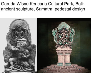
Mahabharata, sheet-anchor of bharatiya itihasa Dr. S. Kalyanaraman Sarasvati Nadi Shodh Prakalp Akhila Bharatiya Itihasa Sankalana Yojana 26/3 Temple Avenue, Srinagar Colony,Chennai 600015 [email_address] http://hindu-tva.com
Eurasia during most extreme part of full glacial conditions (17,000-15,000 14C y.a.) This map concentrates on the time window slightly after the LGM, when aridity seems to have reached its most extreme point. Only slightly moister conditions prevailed for most of the period 22,000-14,000 14C y.a. (25,000-15,000 calendar years ago). A large area of extreme desert conditions existed across central Asia (dark red), surrounded by  semi-desert (light red),  under conditions much colder than the present-day. In the north, Siberia was colder and much  more arid, with steppe-tundra (pink)  and polar desert (grey). Ice masses (light grey) were present in north-western Siberia. In China, colder more arid conditions caused a retreat of forests, with  grasslands (yellow)  and open woodlands (medium green) in southern China and Japan. Forest steppe (violet) and  conifer forest (blue green)  may have predominated elsewhere. In south Asia,  rainforest (darkest green)  retreated and was replaced by grasslands (yellow) and monsoon forests and woodlands (lime-green). Scrub and open woodland (lighest green) probably existed in presently moist forest climates of Bangladesh and SW China. .   http://www.esd.ornl.gov/projects/qen/euras(2.gif
Sapta Sindhu (Nation of Seven Rivers):  Theatre of Pancajanaah,  Five Peoples Marius Fontane, 1881,  Histoire Universelle, Inde Vedique  (de 1800 a 800 av. J.C.), Alphonse Lemerre, Editeur, Paris
Due to plate tectonics, Siwalik ranges shifted laterally creating a gap near Paonta Saheb. Yamuna captured waters of Sarasvati and took them to Ganga to create the Triveni Sangamam.  [Satellite image: NRSA, ISRO, Hyderabad]
Tamasa (with its Yamuna branch) flowed west, in Pa_onta Sa_hab Dun; the west-flowing channels, now called Ba_ta and Ma_rkanda join Sarsuti (with wide channels). Metamorphic rocks from inner Himalaya are found in two old terraces. [KS Valdiya, 2002, Fig. 3.3]
 
Dynamic Indian plate,  dynamic Himalaya Manasarovar, Mt. Kailas summit Plate X [c] Lingam in situ in Trench Ai (MS Vats, 1940,  Excavations at Harappa , Vol. II, Calcutta)
Formation of Gulf of Khambat, ca. 7500 BCE
Kodiyakkara i Talaimannar Pamban Tirutturaipoondibeach (6000 years) Manamelgudi shoreline (6000 years) Devipattinam Ramanathapuram Uchchipuli Thondi
Canyon below the ocean? Question of stability of  any channel on this slope. Abstract   Two suites of slumps from opposite margins of the Gulf of Mannar, between Sri Lanka and southern India, have met and coalesced. The “Eastern Comorin” Slump is the more coherent of the two with a length of 70 to 100 km. The “Colombo” side slump consists of two to four blocks 15 to 35 km in length. Both slump-suites decrease to the south. A paleoslump underlies the western toe of the East Comorin Slump at a depth of some 800 meters. To the south,  an enlarging and deepening submarine canyon marks the area of slump coalescence .   See  William Vestal and Allen Lowrie,  Geology and Geophysics Branch-Code 7220, U.S. Naval Oceanographic Office NSTL Station, 39522, MS     http://www.springerlink.com /content/m602j3k746342lnl/
A volcanic canyon west of Rama Setu, 1 m to 3000 m slope Location map. Inset: bathymetry map of the Gulf of Mannar (reproduced from Murty et al., 1994)   http://www.Setusamudram.in/htmdocs/Articles/cp_rajendran_2.htm
Rama’s hotspot Heatflow in  Rama Setu  100 to 180 milliwatt per sq. m. comparable to Himalayan hotsprings Will dredging in the area activate these heat zones?.
Tsuanmi of Dec. 26, 2004 Result of plate tectonics in Sunda plate
 
Ramayana-Mahabharata Itihasa continuum English word ‘bund’ comes from Bharatiya word: bandha Valmiki describes the construction of Sethu in detai (85 shlokas). hastimaatraan mahaakaayaaH paaSaaNaamshca mahaabalaaH parvataamshca samutpaaTya yantraiH parivahanti ca   Valmiki Ramayana  2-22-58 Vaanara having huge bodies, with mighty strength uprooted elephant-sized rocks and mountains and transported them by mechanical contrivances (yantraih). Vedavyasa refers to Nalasetu nalasetur iti khyāto yo 'dyāpi prathito bhuvi rāmasyājñāṃ puraskṛtya dhāryate girisaṃnibhaḥ   MBh.  3.267.45  .... which even today, popular on earth as Nala's bridge, mountain-like, is sustained out of respect for [Lord] Rama's command. (Nala was son of Vis’wakarma) Kalidasa's Raghuvams’a (sarga 13):  Rama, while returning from SriLanka in pushpaka vimaana: "Behold, Sita, My Sethu  of mountains dividing this frothy ocean is like the milky way dividing the sky into two parts"  Kaavya in Prakrit by  Setubandha Kavya  by the King Damodara Sen (5th Century). King Pravarasena II (550-600 CE) called “ Setu bandha or Ravanavaho, Dasamuha Vadha "
Hanuman at As’okavanam Ganesha as Lipikaara Hanuman speaks in jaati bhaasha Ganesha writes the Mahabharata
 
 
Kilakkarai and other places produce s’ankha, a cultural symbol venerated in Bharatiya traditions (West Bengal Dev. Corpn. In Kilakarai has an annual turnover of Rs. 100 crores to procure s’ankha from Rama Setu coastal zone)
Only Bharatam coastline produces s’ankha
Sri Rama and s’ankha naadam Vishnu’s fight with the Rakshasas led by   Malyava a n, Ma a li and Suma a li as narrated in the Uttarkanda of the Ramayana (Canto VI-VIII)   A Terracotta Panel from Bhitargaon  Showing a Ramayana Scene  By P. B anerjee   http://ignca.nic.in/pb0020.htm
S’ankha is unique to Bharatam coastline, not found anywhere else in the world Date of the woman’s burial with ornaments  6500 Years Before Common Era.   Wide shell-bangle and shell ornaments
The war as shown on an  18th century (?) manuscript.
War began on Nov. 22, 3067 BCE
Bharatam of Mahabharata times
Episodes from Ramayana – a part of Mahabharata, Aranyaka parva
Sri Krishna-Arjuna samvadam -- Rashtrapurusha
Sarasvati civilization sites: Vedic River Sarasvati after KS Valdiya, 2002
Ancient courses of River Sarasvati: ISRO images Sarasvati Sarovar, Adi Badri Reborn Sarasvati, Mohangarh
Schwartzberg Atlas, p. 7, 8 Sarasvati cultures, 3200-900 BCE, p. 9, 10
Sarasvati culture, artefacts
Munda architecture Apsidal Temples, also called Gajaprishtakriti in Sanskrit means an elephant's rump. The first sight of the Chalukyan Apsidal temple of Durgi Gudi at Aihole, fills one with awe and wonder at its perfect apsidal shape. Here Durgi probably refers to a fortified masonry defence structure and Gudi means a temple, probably of Durga, in ancient times. Punch-marked coins found in Karur of the Sangam Age contain symbols taken from Sarasvati hieroglyphs. The Western Chalukya built the Durga temple at Aihole in apsidal shape (ca. 7 th  century CE). Where does the shape come from? The roof of a Toda house in Nilagiri hills of Bharatam, a building in the marshes of Iraq (called mudhif reed-house) or on entrances of Bhaja (Pune, Maharashtra) caitya man-made cave (ca. 150 BCE) in Bharatam. These architectural forms are comparable to the arched-roof shown in the impression of a cylinder seal from Mesopotamia. Note the unicorns (one-horned bulls and heifers) emerging out of the mudhif.  A cognate set of lexemes for ‘reed’ is:  muli  thatching grass (Tu.);  mliu  a reed-like grass (Kui);  mali  a kind of reed of which arrow shafts are made (Malt.)(DEDR 4984). Mudhif is a reed-house in Iraq marshes. Chaitya, Bhaja, 2 nd  century BCE Durga temple, Aihole, Bijapur. Golden apsidal  dome, Chidambaram temple
Tirthasthanas Defining punyabhumi
Balarama’s tirthayatra along Sarasvati: S’alyaparva MBh. Rishi as’rama for rishi tarpan.am and annual melas: Cyavana: Candi Kapila: S’rikolayatji Yajnavalkya, s’aunaka: Jageri, Bikaner Vasishtha: Pehoa (Pr.thudaka) Markandeya: Markanda nadi Samkhya-Kapila – Kalayat Galava - Guldera Salihotra-Asva Shastra –Sarsa Lomaharsha –Lohar Majra Shringi –Saghan Vyasa-Vyasasthali Gautama-Gondar Jamadagni –Jalmana Yayati Tirtha and Surya Kund, Kalwa
Kapila tirtha, Kalayat


Akkadian. Cylinder seal Impression. Inscription records that it belongs to ‘S’u-ilis’u, Meluhha interpreter’, i.e., translator of the Meluhhan language (EME.BAL.ME.LUH.HA.KI) The Meluhhan being introduced carries an  antelope  on his arm. Musee du Louvre. Ao 22 310, Collection De Clercq3rd millennium BCE. The Meluhhan is accompanied by a lady carrying a kaman.d.alu. Since he needed an interpreter, Meluhhan did not speak Akkadian. Antelope carried by the Meluhhan is a hieroglyph: mlekh ‘goat’ (Br.); mr..eka (Te.); me_t.am (Ta.); mes.am (Skt.) Thus, the goat conveys the message that the carrier is a Meluhha. A phonetic determinant.
Tin ingots found in a ship-wreck, Haifa incised with Sarasvati hieroglyphs ran:ku  = tin (Santali) ran:ku  = liquid measure (Santali)  ran:ku  a species of deer;  ran:kuka  (Skt.)(CDIAL 10559). See middle glyph on copper plates m0522 & m0516 ba_t.a  = road (Te.);  bat.a  = kiln (Santali) Da_t.u = cross (Te.); dhatu = mineral (Skt.) [New evidence for sources of and trade in bronze age tin, in: Alan D. Franklin, Jacqueline S. Olin, and Theodore A. Wertime,  The Search for Ancient Tin , 1977, Seminar organized by Theodore A. Wertime and held at the Smithsonian Institution and the  National Bureau of Standards, Washington, D.C., March 14-15, 1977].
 
Bhirdana pottery some semi-precious stones  Structures made of Sun-dried bricks
Bhirdana The excavators have also discovered a 2.4-metre-wide wall considered to be the fortification wall of the township on the excavation site. clinching evidence of the township was that the earth outside the wall comprised of virgin soil while the one inside the fortification wall had all the evidence of structures
Material Cultural of Haryana  Potteries of Kunal C.3 rd  millenium BCE
Source: The Indians And The Amerindians - By Dr. S. Chakravarti
Indian Shipping: High Vessels - Pearl, fishers' Grabs and Catamarans - From "Les Hindous" French early 19th century work.
Kakawin Bharatayuddha First page of J. G. H. Gunning, 1903,  Bhârata-yuddha: Oudjavaansch Heldendicht . ‘s Gravenhage:Martinus Nijhoff. (Text edition in Javanese characters).
Collective memory: Samudramanthanam, Suvarnaphum Airport, Bangkok
Samudramanthanam: Angkor Wat, Cambodia
Garuda Wisnu Kencana Cultural Park, Bali: ancient sculpture, Sumatra; pedestal design
Vishnu.  From Phnom Kulen. 9th Century.  Musée   Guimet
The first dates of the artefacts using the  thermoluminescence  technique  resulted in  4420 BC - 3400 BC  dates, which would have made the site the earliest ever bronze age culture of the world.   Bronze from Ban Chiang, Thailand
TYPES OF FURNACES Large updraft kiln, Harappa (ca. 2400 BCE), found in Mound E, 1984. (After Fig. 8.8, Kenoyer, 1998). A full-scale reconstruction of the ancient Harappan kiln. Harappa Archaeologcal Research Facility used to fire large storage jar, pottery and figurine replicas. (After Fig. 8.9, Kenoyer, 1998) Mohenjodaro, DK-B, C dumps. View of the slag with the coated sub-cylindrical bowl enclosing the stoneware bangles in central position. (After Fig. 1, Massimo Vidale, 1984).
Furnace, Lothal
Raja Nal-ka-tila 3060 BP Malhar 3540 BP Dadupur 3430 BP Lahurdewa 2940 BP Jhulsi 2820 BP  http://antiquity.ac.uk/ProjGall/tewari/tewari.pdf Iron artefacts
Chalcolithic-Iron continuum, 1800 BCE
Black on red ware, Khiplewala, Bahawalpur province; Mughal, M.R., 1997,  Ancient Cholistan , Pl.58 Map showing the probably diffusion of the black-and-red ware techniques and rice cultivation, based on C-14 dates (given in brackets). The earliest appearance of the Black and Red ware is in Lothal (2200 BCE) and next comes Ahar (2000 BCE). The settlement evidence of this chalcolithic culture and the continuity of the vedic traditions in all parts of India indicate an indigenous development of the civilization from ca. 3000 BCE to 650 BCE (Sonpur).
Bronze age sites and  Mleccha-speaker regions
Post-harappa iron age pottery sites


` Nausharo: female figurine. Period 1B, 2800 – 2600 BCE. 11.6 x 30.9 cm.[After Fig. 2.19, Kenoyer, 1998].  Red paint showing sindhur at the parting of the hair;Hair painted black;Necklaces  Painted golden. Painted pot of Nausharo with hieroglyphs. A journalist was sent by Romila to ask Prof. BB Lal: “You have shown the gudiya painted to show sindhur at the parting of the hair. It appears that the gudiya are Hindutva forgeries.” BB Lal replied: “The excavator was a French archaeologist, Jean Paul Jarrige. The workers who discovered the gudiya were Pakistani workers at Nausharo. I don’t think they are Hindu. Accept the fact that the gudiya show the continuity of Bharatiya Samskruti for the last 4500 years.”
Terracotta toys show yogic asanas: 1-4, from Harappa; 5-6, from Mohenjo-daro.  Namaste toy from Mohenjodaro, an abiding tradition of Hindu civilization Narayanam namaskritya naranchaiva narottaman  devim sarasvatinchaiva tato jayamudirayet. 

Mahabharata

  • 1.
    Mahabharata, sheet-anchor ofbharatiya itihasa Dr. S. Kalyanaraman Sarasvati Nadi Shodh Prakalp Akhila Bharatiya Itihasa Sankalana Yojana 26/3 Temple Avenue, Srinagar Colony,Chennai 600015 [email_address] http://hindu-tva.com
  • 2.
    Eurasia during mostextreme part of full glacial conditions (17,000-15,000 14C y.a.) This map concentrates on the time window slightly after the LGM, when aridity seems to have reached its most extreme point. Only slightly moister conditions prevailed for most of the period 22,000-14,000 14C y.a. (25,000-15,000 calendar years ago). A large area of extreme desert conditions existed across central Asia (dark red), surrounded by semi-desert (light red), under conditions much colder than the present-day. In the north, Siberia was colder and much more arid, with steppe-tundra (pink) and polar desert (grey). Ice masses (light grey) were present in north-western Siberia. In China, colder more arid conditions caused a retreat of forests, with grasslands (yellow) and open woodlands (medium green) in southern China and Japan. Forest steppe (violet) and conifer forest (blue green) may have predominated elsewhere. In south Asia, rainforest (darkest green) retreated and was replaced by grasslands (yellow) and monsoon forests and woodlands (lime-green). Scrub and open woodland (lighest green) probably existed in presently moist forest climates of Bangladesh and SW China. . http://www.esd.ornl.gov/projects/qen/euras(2.gif
  • 3.
    Sapta Sindhu (Nationof Seven Rivers): Theatre of Pancajanaah, Five Peoples Marius Fontane, 1881, Histoire Universelle, Inde Vedique (de 1800 a 800 av. J.C.), Alphonse Lemerre, Editeur, Paris
  • 4.
    Due to platetectonics, Siwalik ranges shifted laterally creating a gap near Paonta Saheb. Yamuna captured waters of Sarasvati and took them to Ganga to create the Triveni Sangamam. [Satellite image: NRSA, ISRO, Hyderabad]
  • 5.
    Tamasa (with itsYamuna branch) flowed west, in Pa_onta Sa_hab Dun; the west-flowing channels, now called Ba_ta and Ma_rkanda join Sarsuti (with wide channels). Metamorphic rocks from inner Himalaya are found in two old terraces. [KS Valdiya, 2002, Fig. 3.3]
  • 6.
  • 7.
    Dynamic Indian plate, dynamic Himalaya Manasarovar, Mt. Kailas summit Plate X [c] Lingam in situ in Trench Ai (MS Vats, 1940, Excavations at Harappa , Vol. II, Calcutta)
  • 8.
    Formation of Gulfof Khambat, ca. 7500 BCE
  • 9.
    Kodiyakkara i TalaimannarPamban Tirutturaipoondibeach (6000 years) Manamelgudi shoreline (6000 years) Devipattinam Ramanathapuram Uchchipuli Thondi
  • 10.
    Canyon below theocean? Question of stability of any channel on this slope. Abstract   Two suites of slumps from opposite margins of the Gulf of Mannar, between Sri Lanka and southern India, have met and coalesced. The “Eastern Comorin” Slump is the more coherent of the two with a length of 70 to 100 km. The “Colombo” side slump consists of two to four blocks 15 to 35 km in length. Both slump-suites decrease to the south. A paleoslump underlies the western toe of the East Comorin Slump at a depth of some 800 meters. To the south, an enlarging and deepening submarine canyon marks the area of slump coalescence . See William Vestal and Allen Lowrie, Geology and Geophysics Branch-Code 7220, U.S. Naval Oceanographic Office NSTL Station, 39522, MS     http://www.springerlink.com /content/m602j3k746342lnl/
  • 11.
    A volcanic canyonwest of Rama Setu, 1 m to 3000 m slope Location map. Inset: bathymetry map of the Gulf of Mannar (reproduced from Murty et al., 1994) http://www.Setusamudram.in/htmdocs/Articles/cp_rajendran_2.htm
  • 12.
    Rama’s hotspot Heatflowin Rama Setu 100 to 180 milliwatt per sq. m. comparable to Himalayan hotsprings Will dredging in the area activate these heat zones?.
  • 13.
    Tsuanmi of Dec.26, 2004 Result of plate tectonics in Sunda plate
  • 14.
  • 15.
    Ramayana-Mahabharata Itihasa continuumEnglish word ‘bund’ comes from Bharatiya word: bandha Valmiki describes the construction of Sethu in detai (85 shlokas). hastimaatraan mahaakaayaaH paaSaaNaamshca mahaabalaaH parvataamshca samutpaaTya yantraiH parivahanti ca Valmiki Ramayana 2-22-58 Vaanara having huge bodies, with mighty strength uprooted elephant-sized rocks and mountains and transported them by mechanical contrivances (yantraih). Vedavyasa refers to Nalasetu nalasetur iti khyāto yo 'dyāpi prathito bhuvi rāmasyājñāṃ puraskṛtya dhāryate girisaṃnibhaḥ MBh. 3.267.45 .... which even today, popular on earth as Nala's bridge, mountain-like, is sustained out of respect for [Lord] Rama's command. (Nala was son of Vis’wakarma) Kalidasa's Raghuvams’a (sarga 13): Rama, while returning from SriLanka in pushpaka vimaana: "Behold, Sita, My Sethu  of mountains dividing this frothy ocean is like the milky way dividing the sky into two parts" Kaavya in Prakrit by Setubandha Kavya by the King Damodara Sen (5th Century). King Pravarasena II (550-600 CE) called “ Setu bandha or Ravanavaho, Dasamuha Vadha "
  • 16.
    Hanuman at As’okavanamGanesha as Lipikaara Hanuman speaks in jaati bhaasha Ganesha writes the Mahabharata
  • 17.
  • 18.
  • 19.
    Kilakkarai and otherplaces produce s’ankha, a cultural symbol venerated in Bharatiya traditions (West Bengal Dev. Corpn. In Kilakarai has an annual turnover of Rs. 100 crores to procure s’ankha from Rama Setu coastal zone)
  • 20.
    Only Bharatam coastlineproduces s’ankha
  • 21.
    Sri Rama ands’ankha naadam Vishnu’s fight with the Rakshasas led by Malyava a n, Ma a li and Suma a li as narrated in the Uttarkanda of the Ramayana (Canto VI-VIII) A Terracotta Panel from Bhitargaon Showing a Ramayana Scene By P. B anerjee http://ignca.nic.in/pb0020.htm
  • 22.
    S’ankha is uniqueto Bharatam coastline, not found anywhere else in the world Date of the woman’s burial with ornaments 6500 Years Before Common Era. Wide shell-bangle and shell ornaments
  • 23.
    The war asshown on an 18th century (?) manuscript.
  • 24.
    War began onNov. 22, 3067 BCE
  • 25.
  • 26.
    Episodes from Ramayana– a part of Mahabharata, Aranyaka parva
  • 27.
    Sri Krishna-Arjuna samvadam-- Rashtrapurusha
  • 28.
    Sarasvati civilization sites:Vedic River Sarasvati after KS Valdiya, 2002
  • 29.
    Ancient courses ofRiver Sarasvati: ISRO images Sarasvati Sarovar, Adi Badri Reborn Sarasvati, Mohangarh
  • 30.
    Schwartzberg Atlas, p.7, 8 Sarasvati cultures, 3200-900 BCE, p. 9, 10
  • 31.
  • 32.
    Munda architecture ApsidalTemples, also called Gajaprishtakriti in Sanskrit means an elephant's rump. The first sight of the Chalukyan Apsidal temple of Durgi Gudi at Aihole, fills one with awe and wonder at its perfect apsidal shape. Here Durgi probably refers to a fortified masonry defence structure and Gudi means a temple, probably of Durga, in ancient times. Punch-marked coins found in Karur of the Sangam Age contain symbols taken from Sarasvati hieroglyphs. The Western Chalukya built the Durga temple at Aihole in apsidal shape (ca. 7 th century CE). Where does the shape come from? The roof of a Toda house in Nilagiri hills of Bharatam, a building in the marshes of Iraq (called mudhif reed-house) or on entrances of Bhaja (Pune, Maharashtra) caitya man-made cave (ca. 150 BCE) in Bharatam. These architectural forms are comparable to the arched-roof shown in the impression of a cylinder seal from Mesopotamia. Note the unicorns (one-horned bulls and heifers) emerging out of the mudhif. A cognate set of lexemes for ‘reed’ is: muli thatching grass (Tu.); mliu a reed-like grass (Kui); mali a kind of reed of which arrow shafts are made (Malt.)(DEDR 4984). Mudhif is a reed-house in Iraq marshes. Chaitya, Bhaja, 2 nd century BCE Durga temple, Aihole, Bijapur. Golden apsidal dome, Chidambaram temple
  • 33.
  • 34.
    Balarama’s tirthayatra alongSarasvati: S’alyaparva MBh. Rishi as’rama for rishi tarpan.am and annual melas: Cyavana: Candi Kapila: S’rikolayatji Yajnavalkya, s’aunaka: Jageri, Bikaner Vasishtha: Pehoa (Pr.thudaka) Markandeya: Markanda nadi Samkhya-Kapila – Kalayat Galava - Guldera Salihotra-Asva Shastra –Sarsa Lomaharsha –Lohar Majra Shringi –Saghan Vyasa-Vyasasthali Gautama-Gondar Jamadagni –Jalmana Yayati Tirtha and Surya Kund, Kalwa
  • 35.
  • 36.
  • 37.
  • 38.
  • 39.
    Akkadian. Cylinder sealImpression. Inscription records that it belongs to ‘S’u-ilis’u, Meluhha interpreter’, i.e., translator of the Meluhhan language (EME.BAL.ME.LUH.HA.KI) The Meluhhan being introduced carries an antelope on his arm. Musee du Louvre. Ao 22 310, Collection De Clercq3rd millennium BCE. The Meluhhan is accompanied by a lady carrying a kaman.d.alu. Since he needed an interpreter, Meluhhan did not speak Akkadian. Antelope carried by the Meluhhan is a hieroglyph: mlekh ‘goat’ (Br.); mr..eka (Te.); me_t.am (Ta.); mes.am (Skt.) Thus, the goat conveys the message that the carrier is a Meluhha. A phonetic determinant.
  • 40.
    Tin ingots foundin a ship-wreck, Haifa incised with Sarasvati hieroglyphs ran:ku = tin (Santali) ran:ku = liquid measure (Santali) ran:ku a species of deer; ran:kuka (Skt.)(CDIAL 10559). See middle glyph on copper plates m0522 & m0516 ba_t.a = road (Te.); bat.a = kiln (Santali) Da_t.u = cross (Te.); dhatu = mineral (Skt.) [New evidence for sources of and trade in bronze age tin, in: Alan D. Franklin, Jacqueline S. Olin, and Theodore A. Wertime, The Search for Ancient Tin , 1977, Seminar organized by Theodore A. Wertime and held at the Smithsonian Institution and the National Bureau of Standards, Washington, D.C., March 14-15, 1977].
  • 41.
  • 42.
    Bhirdana pottery somesemi-precious stones Structures made of Sun-dried bricks
  • 43.
    Bhirdana The excavatorshave also discovered a 2.4-metre-wide wall considered to be the fortification wall of the township on the excavation site. clinching evidence of the township was that the earth outside the wall comprised of virgin soil while the one inside the fortification wall had all the evidence of structures
  • 44.
    Material Cultural ofHaryana Potteries of Kunal C.3 rd millenium BCE
  • 45.
    Source: The IndiansAnd The Amerindians - By Dr. S. Chakravarti
  • 46.
    Indian Shipping: HighVessels - Pearl, fishers' Grabs and Catamarans - From "Les Hindous" French early 19th century work.
  • 47.
    Kakawin Bharatayuddha Firstpage of J. G. H. Gunning, 1903, Bhârata-yuddha: Oudjavaansch Heldendicht . ‘s Gravenhage:Martinus Nijhoff. (Text edition in Javanese characters).
  • 48.
    Collective memory: Samudramanthanam,Suvarnaphum Airport, Bangkok
  • 49.
  • 50.
    Garuda Wisnu KencanaCultural Park, Bali: ancient sculpture, Sumatra; pedestal design
  • 51.
    Vishnu. FromPhnom Kulen. 9th Century. Musée Guimet
  • 52.
    The first datesof the artefacts using the thermoluminescence technique resulted in 4420 BC - 3400 BC dates, which would have made the site the earliest ever bronze age culture of the world. Bronze from Ban Chiang, Thailand
  • 53.
    TYPES OF FURNACESLarge updraft kiln, Harappa (ca. 2400 BCE), found in Mound E, 1984. (After Fig. 8.8, Kenoyer, 1998). A full-scale reconstruction of the ancient Harappan kiln. Harappa Archaeologcal Research Facility used to fire large storage jar, pottery and figurine replicas. (After Fig. 8.9, Kenoyer, 1998) Mohenjodaro, DK-B, C dumps. View of the slag with the coated sub-cylindrical bowl enclosing the stoneware bangles in central position. (After Fig. 1, Massimo Vidale, 1984).
  • 54.
  • 55.
    Raja Nal-ka-tila 3060BP Malhar 3540 BP Dadupur 3430 BP Lahurdewa 2940 BP Jhulsi 2820 BP http://antiquity.ac.uk/ProjGall/tewari/tewari.pdf Iron artefacts
  • 56.
  • 57.
    Black on redware, Khiplewala, Bahawalpur province; Mughal, M.R., 1997, Ancient Cholistan , Pl.58 Map showing the probably diffusion of the black-and-red ware techniques and rice cultivation, based on C-14 dates (given in brackets). The earliest appearance of the Black and Red ware is in Lothal (2200 BCE) and next comes Ahar (2000 BCE). The settlement evidence of this chalcolithic culture and the continuity of the vedic traditions in all parts of India indicate an indigenous development of the civilization from ca. 3000 BCE to 650 BCE (Sonpur).
  • 58.
    Bronze age sitesand Mleccha-speaker regions
  • 59.
    Post-harappa iron agepottery sites
  • 60.
  • 61.
  • 62.
  • 63.
  • 64.
    ` Nausharo: femalefigurine. Period 1B, 2800 – 2600 BCE. 11.6 x 30.9 cm.[After Fig. 2.19, Kenoyer, 1998]. Red paint showing sindhur at the parting of the hair;Hair painted black;Necklaces Painted golden. Painted pot of Nausharo with hieroglyphs. A journalist was sent by Romila to ask Prof. BB Lal: “You have shown the gudiya painted to show sindhur at the parting of the hair. It appears that the gudiya are Hindutva forgeries.” BB Lal replied: “The excavator was a French archaeologist, Jean Paul Jarrige. The workers who discovered the gudiya were Pakistani workers at Nausharo. I don’t think they are Hindu. Accept the fact that the gudiya show the continuity of Bharatiya Samskruti for the last 4500 years.”
  • 65.
    Terracotta toys showyogic asanas: 1-4, from Harappa; 5-6, from Mohenjo-daro. Namaste toy from Mohenjodaro, an abiding tradition of Hindu civilization Narayanam namaskritya naranchaiva narottaman devim sarasvatinchaiva tato jayamudirayet.