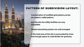
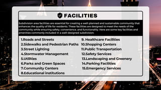
SITE AND AREA
PLANNING
PROJECT TITLE: SUBDIVISION LAYOUT PLAN OF MANSURABAD NIRIBILI
RESIDENTIAL AREA -5
SUBMITTED TO: ASHRAF UDDIN FAHIM
ASSISTANT PROFESSOR
DEPARTMENT OF URP,PUST
SUBMITTED BY: MD. SALMAN KHAN NOYON-211709
MD. FOISHAL AHMED-211710
MD.JAHIDUL ISLAM-211705
SOVON BISWAS-211707
KAMRUNNESA SUMI-211722
MST. SANJIDA KHATUN-211739
MOSABBIR ABDULLAH-201740
MANSURABAD NIRIBILI ABASAN PROKALPA
01
About Us
02
Goal
03
Methodology
04
Study area profile
05
Area features
06
Facilities
07
Limitations
11
conclusion
Objectives
08 09 10
Pattern of
subdivision layout
Measurment
We, a group of seven member studied
Mansurabad Niribili Residential area trying
to make subdivision layout plan. We used
AUTOCAD as main tool with the help of
Adobe Illustrator.
ABOUT US
we are here to represent the subdivision
plan with some basic outputs.
01 To provide better facilities with the
lowest limitations.
GOALS
02
03 we are providing facilities for a long
period of time .
To combine commercial area with
residential as well as business area.
STUDY AREA PROFILE
Profile 1
Front gate
Profile 2
Approximately
34 acre provided
flat land area
which is beside
a highway as
well as open
area in more
than one sides.
Proposed Land Area
Profile 3
05 KM from main
Pabna town and
nearby Pabna
univarsity of Science
of Teachnology
Proposed Land Area
Entering the
land area
from Dhaka-
Pabna
Highway.
4.providing
enough
recreational
facilities for all
ages of people.
1.Providing suitable
road network in the
residential area to
ensure easy movement
5.Providing
necessary
public utility
services.
2.Providing
environment
friendly
residential area
3.Ensuring
necessary
community
facilities
Objectives :
METHODOLOGY OF SUBDIVISION PLAN:
Project Identification
01
Site information survey
02
zoning and road distribution
03 04
05
Study the survey area
Completaion of final layout in
AUTOCAD
Area distribution and plotting
06
MEASUREMENTS:
1.Total population: around 3000
2.total Area:Approximately 34 Acre.
3.Total plot: 455
4.Residential Area:64%
5.Road:9%
6.Open space, Green Area:8%
5.Commercial Area:9%
6.Business Area: 4%
7.Recreation Area:3.33%
8.Public utility:1.67%
9.water body:1%
PATTERN OF SUBDIVISION LAYOUT:
1.combination of modified grid pattern,cul-de-
sec pattern ,radial pattern.
2.In this site the utility facilities are very
accessible.
3.Road networking system are well arranged.
4.The total area of the site is surrounded by trees
and enough space on road divider for greenery.
FEATURES:
1.Streets and Roads: streets, roads, alleys, and other public or private rights-of-way.
2.Easements:water, sewer, gas, electricity
3.Common Areas: parks, playgrounds, or shared amenities.
4.Utility Infrastructure:water lines, sewer lines, and electrical distribution.
5.Street Names and Addresses: Proposed street names and addresses for each.
6.Legal Descriptions: Detailed legal descriptions of each plot.
7.North Arrow and Scale: Indicate the orientation of the plan.
8.Lot Layout: Including their size, shape, and dimensions and plot number for
identification.
9.Property Boundaries: Clear delineation of property boundaries for each lot.
Subdivision area facilities are essential for creating a well-planned and sustainable community that
enhances the quality of life for residents. These facilities are designed to meet the needs of the
community while ensuring safety, convenience, and functionality. Here are some key facilities and
amenities commonly included in a well-designed subdivision:
FACILITIES
1.Roads and Streets 9. Healthcare Facilities
2.Sidewalks and Pedestrian Paths 10.Shopping Centers
3.Street Lighting 11.Public Transportation
4.Stormwater Management 12.Safety Services
5.Utilities 13.Landscaping and Greenery
6.Parks and Green Spaces 14.Parking Facilities
7.Community Centers 15.Emergency Services
8.Educational institutions
LIMITATIONS:
1.We have not provided with proffessional tools.
2.The land area is not regular in shape
3.Due to the distance of the land from the town
is far enough, all the facilities are provided in a
small place.
CONCLUSION:
our subdivision area project represents a transformative vision for a thriving and sustainable community.
We have carefully considered the needs and aspirations of the residents and the surrounding
environment, aiming to create a place where people can live, work, and play harmoniously. With a
commitment to responsible planning, infrastructure development, and environmental stewardship, our
project is poised to bring numerous benefits to the community, including improved quality of life,
economic growth, and enhanced green spaces. We invite you to join us on this journey to shape a better
future for all, and we look forward to your support and collaboration as we take the next steps toward
making this vision a reality.
Subdivision presentation.pdf

Subdivision presentation.pdf

  • 1.
    SITE AND AREA PLANNING PROJECTTITLE: SUBDIVISION LAYOUT PLAN OF MANSURABAD NIRIBILI RESIDENTIAL AREA -5 SUBMITTED TO: ASHRAF UDDIN FAHIM ASSISTANT PROFESSOR DEPARTMENT OF URP,PUST SUBMITTED BY: MD. SALMAN KHAN NOYON-211709 MD. FOISHAL AHMED-211710 MD.JAHIDUL ISLAM-211705 SOVON BISWAS-211707 KAMRUNNESA SUMI-211722 MST. SANJIDA KHATUN-211739 MOSABBIR ABDULLAH-201740 MANSURABAD NIRIBILI ABASAN PROKALPA
  • 2.
    01 About Us 02 Goal 03 Methodology 04 Study areaprofile 05 Area features 06 Facilities 07 Limitations 11 conclusion Objectives 08 09 10 Pattern of subdivision layout Measurment
  • 3.
    We, a groupof seven member studied Mansurabad Niribili Residential area trying to make subdivision layout plan. We used AUTOCAD as main tool with the help of Adobe Illustrator. ABOUT US we are here to represent the subdivision plan with some basic outputs.
  • 4.
    01 To providebetter facilities with the lowest limitations. GOALS 02 03 we are providing facilities for a long period of time . To combine commercial area with residential as well as business area.
  • 5.
    STUDY AREA PROFILE Profile1 Front gate Profile 2 Approximately 34 acre provided flat land area which is beside a highway as well as open area in more than one sides. Proposed Land Area Profile 3 05 KM from main Pabna town and nearby Pabna univarsity of Science of Teachnology Proposed Land Area Entering the land area from Dhaka- Pabna Highway.
  • 6.
    4.providing enough recreational facilities for all agesof people. 1.Providing suitable road network in the residential area to ensure easy movement 5.Providing necessary public utility services. 2.Providing environment friendly residential area 3.Ensuring necessary community facilities Objectives :
  • 7.
    METHODOLOGY OF SUBDIVISIONPLAN: Project Identification 01 Site information survey 02 zoning and road distribution 03 04 05 Study the survey area Completaion of final layout in AUTOCAD Area distribution and plotting 06
  • 8.
    MEASUREMENTS: 1.Total population: around3000 2.total Area:Approximately 34 Acre. 3.Total plot: 455 4.Residential Area:64% 5.Road:9% 6.Open space, Green Area:8% 5.Commercial Area:9% 6.Business Area: 4% 7.Recreation Area:3.33% 8.Public utility:1.67% 9.water body:1%
  • 9.
    PATTERN OF SUBDIVISIONLAYOUT: 1.combination of modified grid pattern,cul-de- sec pattern ,radial pattern. 2.In this site the utility facilities are very accessible. 3.Road networking system are well arranged. 4.The total area of the site is surrounded by trees and enough space on road divider for greenery.
  • 10.
    FEATURES: 1.Streets and Roads:streets, roads, alleys, and other public or private rights-of-way. 2.Easements:water, sewer, gas, electricity 3.Common Areas: parks, playgrounds, or shared amenities. 4.Utility Infrastructure:water lines, sewer lines, and electrical distribution. 5.Street Names and Addresses: Proposed street names and addresses for each. 6.Legal Descriptions: Detailed legal descriptions of each plot. 7.North Arrow and Scale: Indicate the orientation of the plan. 8.Lot Layout: Including their size, shape, and dimensions and plot number for identification. 9.Property Boundaries: Clear delineation of property boundaries for each lot.
  • 11.
    Subdivision area facilitiesare essential for creating a well-planned and sustainable community that enhances the quality of life for residents. These facilities are designed to meet the needs of the community while ensuring safety, convenience, and functionality. Here are some key facilities and amenities commonly included in a well-designed subdivision: FACILITIES 1.Roads and Streets 9. Healthcare Facilities 2.Sidewalks and Pedestrian Paths 10.Shopping Centers 3.Street Lighting 11.Public Transportation 4.Stormwater Management 12.Safety Services 5.Utilities 13.Landscaping and Greenery 6.Parks and Green Spaces 14.Parking Facilities 7.Community Centers 15.Emergency Services 8.Educational institutions
  • 12.
    LIMITATIONS: 1.We have notprovided with proffessional tools. 2.The land area is not regular in shape 3.Due to the distance of the land from the town is far enough, all the facilities are provided in a small place.
  • 13.
    CONCLUSION: our subdivision areaproject represents a transformative vision for a thriving and sustainable community. We have carefully considered the needs and aspirations of the residents and the surrounding environment, aiming to create a place where people can live, work, and play harmoniously. With a commitment to responsible planning, infrastructure development, and environmental stewardship, our project is poised to bring numerous benefits to the community, including improved quality of life, economic growth, and enhanced green spaces. We invite you to join us on this journey to shape a better future for all, and we look forward to your support and collaboration as we take the next steps toward making this vision a reality.