SlideShare a Scribd company logo
Approved for Public Release 09/2013
13-MDA-7601 (21 October 13)
Space Tracking and Surveillance System
 The Missile Defense Agency (MDA) operates the Space Tracking and Surveillance System-
Demonstrators (STSS-D). STSS-D constellation consists of two satellites orbiting at 1350 km,
58 degree inclination, with 120 minute orbital period. Using sensors capable of detecting visible
and infrared light, STSS-D serves as the experimental space layer of the Ballistic Missile
Defense System (BMDS).
 Mission Objective: Provide Accurate Tracks of Midcourse Re-entry Vehicles to the Shooter.
 Boosting targets detected by acquisition sensor – continuously scans visible Earth in Short-
Wave Infrared band.
 Targets autonomously handed-off to track sensor – Sensitivity/Wavebands enable midcourse tracking.
 Target 2-D Line-of-Sight reported to ground via Object Sighting Messages.
 Ground forms high accuracy 3-D track from stereo Object Sighting Messages.
 3-D tracks reported to the Ballistic Missile Defense System (BMDS).
Program Overview
 On Sept. 25, 2009, MDA, NASA, and the Air Force teamed to successfully launch two tandem satellites into low earth orbit on a NASA Delta II
launch vehicle from Cape Canaveral, Fla.
 Both satellites are operating nominally on-orbit under the control of the Missile Defense Space Development Center (MDSDC).
 STSS-D is participating in integrated BMDS testing and providing significant risk reduction in support of the development and fielding of a future
missile defense operational satellite constellation.
Program Update and Accomplishments
 STSS-D satellites completed an Early On-orbit Test series of 127 System Functionality Tests and achieved a critical milestone of demonstrating
full calibrated performance of both satellites, their crosslink systems, and the acquisition and track sensor payloads.
 First stereo collection on birth-to-death missile flight and provided the missile tracking data to the BMDS in near real-time.
 First on-orbit demonstration of receipt of an external cue and the use of the STSS-D crosslink to transmit that cue to the out-of-view satellite,
resulting in stereo midcourse tracking and first observation of missile intercept from low earth orbit.
 First Aegis remote engagement based on STSS-D tracking data resulting in a successful missile intercept (FTM-20).
 Transferred STSS-D Program Office Responsibility from SMC, Los Angeles AFB, Calif. to MDSDC, Colorado Springs, Colo.
Program Outlook
 Validate remote sensor and fire control integration to inform the design and operations of the next generation space tracking system, to
characterize the contribution of space data into the BMDS architecture, and to provide sensor measurements and background data supporting
trade studies and analysis for BMDS systems.
 Integrate space capabilities into the BMDS architecture and collaborate with Air Force Space Command on studies and experiments to optimize
next generation tracking satellites support for Space Situational Awareness (SSA) functionality.
 Continue to participate in MDA scheduled test events and track available targets and missiles in all phases of flight and provide track data to the
integrated BMDS.
 Provide invaluable engineering and integration data for development of a follow-on operational BMDS Space Layer for accurate and timely
object tracking and reporting of missile attacks against U.S., its allies, and deployed forces.

More Related Content

What's hot

IGARSS2011_radarvolcanology.pptx
IGARSS2011_radarvolcanology.pptxIGARSS2011_radarvolcanology.pptx
IGARSS2011_radarvolcanology.pptx
grssieee
 
Introduction to gps [compatibility mode]
Introduction to gps [compatibility mode]Introduction to gps [compatibility mode]
Introduction to gps [compatibility mode]
Sumanta Das
 
TU2.T10.1.pptx
TU2.T10.1.pptxTU2.T10.1.pptx
TU2.T10.1.pptx
grssieee
 
Karakterisasi Letusan Merapi menggunakan Data SAR (Synthetic Aperture Radar)
Karakterisasi Letusan Merapi menggunakan Data SAR (Synthetic Aperture Radar)Karakterisasi Letusan Merapi menggunakan Data SAR (Synthetic Aperture Radar)
Karakterisasi Letusan Merapi menggunakan Data SAR (Synthetic Aperture Radar)
Achmad Darul
 

What's hot (20)

GPS introduction
GPS introductionGPS introduction
GPS introduction
 
IGARSS2011_radarvolcanology.pptx
IGARSS2011_radarvolcanology.pptxIGARSS2011_radarvolcanology.pptx
IGARSS2011_radarvolcanology.pptx
 
Google Techtalk 2006
Google Techtalk 2006Google Techtalk 2006
Google Techtalk 2006
 
Glonass
GlonassGlonass
Glonass
 
Introduction to GPS
Introduction to GPSIntroduction to GPS
Introduction to GPS
 
DSD-INT 2015 - from promise to practice - the lessons we needed to learn to m...
DSD-INT 2015 - from promise to practice - the lessons we needed to learn to m...DSD-INT 2015 - from promise to practice - the lessons we needed to learn to m...
DSD-INT 2015 - from promise to practice - the lessons we needed to learn to m...
 
GPS application soil survey
GPS application soil surveyGPS application soil survey
GPS application soil survey
 
COSMO-SkyMed
COSMO-SkyMedCOSMO-SkyMed
COSMO-SkyMed
 
FDL 2017 Long Period Comets Final Presentation
FDL 2017 Long Period Comets Final PresentationFDL 2017 Long Period Comets Final Presentation
FDL 2017 Long Period Comets Final Presentation
 
FDL 2017 3D Shape Modeling
FDL 2017 3D Shape ModelingFDL 2017 3D Shape Modeling
FDL 2017 3D Shape Modeling
 
Presentation
PresentationPresentation
Presentation
 
Introduction to gps [compatibility mode]
Introduction to gps [compatibility mode]Introduction to gps [compatibility mode]
Introduction to gps [compatibility mode]
 
GPS
GPS GPS
GPS
 
introduction-of-GNSS-1
introduction-of-GNSS-1introduction-of-GNSS-1
introduction-of-GNSS-1
 
Global positioning system (gps)
Global positioning  system (gps)Global positioning  system (gps)
Global positioning system (gps)
 
Gps and remote sensing
Gps and remote sensingGps and remote sensing
Gps and remote sensing
 
GPS
GPSGPS
GPS
 
TU2.T10.1.pptx
TU2.T10.1.pptxTU2.T10.1.pptx
TU2.T10.1.pptx
 
Karakterisasi Letusan Merapi menggunakan Data SAR (Synthetic Aperture Radar)
Karakterisasi Letusan Merapi menggunakan Data SAR (Synthetic Aperture Radar)Karakterisasi Letusan Merapi menggunakan Data SAR (Synthetic Aperture Radar)
Karakterisasi Letusan Merapi menggunakan Data SAR (Synthetic Aperture Radar)
 
NU100 Primer
NU100 PrimerNU100 Primer
NU100 Primer
 

Similar to stss

GPS and Weapons Technology
GPS  and Weapons TechnologyGPS  and Weapons Technology
GPS and Weapons Technology
Suchit Moon
 
Communication Systems Proposal- Final
Communication Systems Proposal- FinalCommunication Systems Proposal- Final
Communication Systems Proposal- Final
Christine Odenwald
 
Global Positioning System
Global Positioning SystemGlobal Positioning System
Global Positioning System
Ishwar Bulbule
 
Space based infrared system(sbirs), usa one of the nation’s highest priorit...
Space based infrared system(sbirs), usa   one of the nation’s highest priorit...Space based infrared system(sbirs), usa   one of the nation’s highest priorit...
Space based infrared system(sbirs), usa one of the nation’s highest priorit...
hindujudaic
 
body_The_Case_for_APNT_Development_for_Aviation
body_The_Case_for_APNT_Development_for_Aviationbody_The_Case_for_APNT_Development_for_Aviation
body_The_Case_for_APNT_Development_for_Aviation
Ariel Scheirer
 

Similar to stss (20)
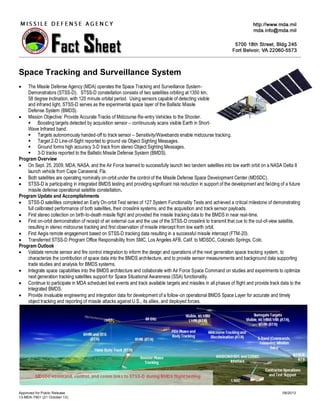
GPS and weapon technology methods for missiles: an overview
GPS and weapon technology methods for missiles: an overviewGPS and weapon technology methods for missiles: an overview
GPS and weapon technology methods for missiles: an overview
 
GPS and Weapons Technology
GPS  and Weapons TechnologyGPS  and Weapons Technology
GPS and Weapons Technology
 
Communication Systems Proposal- Final
Communication Systems Proposal- FinalCommunication Systems Proposal- Final
Communication Systems Proposal- Final
 
Gps
GpsGps
Gps
 
Global Positioning System
Global Positioning SystemGlobal Positioning System
Global Positioning System
 
Space based infrared system(sbirs), usa one of the nation’s highest priorit...
Space based infrared system(sbirs), usa   one of the nation’s highest priorit...Space based infrared system(sbirs), usa   one of the nation’s highest priorit...
Space based infrared system(sbirs), usa one of the nation’s highest priorit...
 
Location in ubiquitous computing, LOCATION SYSTEMS
Location in ubiquitous computing, LOCATION SYSTEMSLocation in ubiquitous computing, LOCATION SYSTEMS
Location in ubiquitous computing, LOCATION SYSTEMS
 
body_The_Case_for_APNT_Development_for_Aviation
body_The_Case_for_APNT_Development_for_Aviationbody_The_Case_for_APNT_Development_for_Aviation
body_The_Case_for_APNT_Development_for_Aviation
 
Iridium Satellite Communications System, Tsunami Warning System
Iridium Satellite Communications System, Tsunami Warning SystemIridium Satellite Communications System, Tsunami Warning System
Iridium Satellite Communications System, Tsunami Warning System
 
Global Positioning System
Global Positioning SystemGlobal Positioning System
Global Positioning System
 
Gps
GpsGps
Gps
 
Military Radar System
Military Radar SystemMilitary Radar System
Military Radar System
 
Presentation
PresentationPresentation
Presentation
 
Presentation
PresentationPresentation
Presentation
 
Presentation
PresentationPresentation
Presentation
 
Presentation
PresentationPresentation
Presentation
 
Gps
GpsGps
Gps
 
SMDC-One
SMDC-OneSMDC-One
SMDC-One
 
Map Projections, Datums, GIS and GPS for Everyone
Map Projections, Datums, GIS and GPS for EveryoneMap Projections, Datums, GIS and GPS for Everyone
Map Projections, Datums, GIS and GPS for Everyone
 
CE203 -Photogrammetry & GPS.ppt
CE203 -Photogrammetry & GPS.pptCE203 -Photogrammetry & GPS.ppt
CE203 -Photogrammetry & GPS.ppt
 

stss

  • 1. Approved for Public Release 09/2013 13-MDA-7601 (21 October 13) Space Tracking and Surveillance System  The Missile Defense Agency (MDA) operates the Space Tracking and Surveillance System- Demonstrators (STSS-D). STSS-D constellation consists of two satellites orbiting at 1350 km, 58 degree inclination, with 120 minute orbital period. Using sensors capable of detecting visible and infrared light, STSS-D serves as the experimental space layer of the Ballistic Missile Defense System (BMDS).  Mission Objective: Provide Accurate Tracks of Midcourse Re-entry Vehicles to the Shooter.  Boosting targets detected by acquisition sensor – continuously scans visible Earth in Short- Wave Infrared band.  Targets autonomously handed-off to track sensor – Sensitivity/Wavebands enable midcourse tracking.  Target 2-D Line-of-Sight reported to ground via Object Sighting Messages.  Ground forms high accuracy 3-D track from stereo Object Sighting Messages.  3-D tracks reported to the Ballistic Missile Defense System (BMDS). Program Overview  On Sept. 25, 2009, MDA, NASA, and the Air Force teamed to successfully launch two tandem satellites into low earth orbit on a NASA Delta II launch vehicle from Cape Canaveral, Fla.  Both satellites are operating nominally on-orbit under the control of the Missile Defense Space Development Center (MDSDC).  STSS-D is participating in integrated BMDS testing and providing significant risk reduction in support of the development and fielding of a future missile defense operational satellite constellation. Program Update and Accomplishments  STSS-D satellites completed an Early On-orbit Test series of 127 System Functionality Tests and achieved a critical milestone of demonstrating full calibrated performance of both satellites, their crosslink systems, and the acquisition and track sensor payloads.  First stereo collection on birth-to-death missile flight and provided the missile tracking data to the BMDS in near real-time.  First on-orbit demonstration of receipt of an external cue and the use of the STSS-D crosslink to transmit that cue to the out-of-view satellite, resulting in stereo midcourse tracking and first observation of missile intercept from low earth orbit.  First Aegis remote engagement based on STSS-D tracking data resulting in a successful missile intercept (FTM-20).  Transferred STSS-D Program Office Responsibility from SMC, Los Angeles AFB, Calif. to MDSDC, Colorado Springs, Colo. Program Outlook  Validate remote sensor and fire control integration to inform the design and operations of the next generation space tracking system, to characterize the contribution of space data into the BMDS architecture, and to provide sensor measurements and background data supporting trade studies and analysis for BMDS systems.  Integrate space capabilities into the BMDS architecture and collaborate with Air Force Space Command on studies and experiments to optimize next generation tracking satellites support for Space Situational Awareness (SSA) functionality.  Continue to participate in MDA scheduled test events and track available targets and missiles in all phases of flight and provide track data to the integrated BMDS.  Provide invaluable engineering and integration data for development of a follow-on operational BMDS Space Layer for accurate and timely object tracking and reporting of missile attacks against U.S., its allies, and deployed forces.