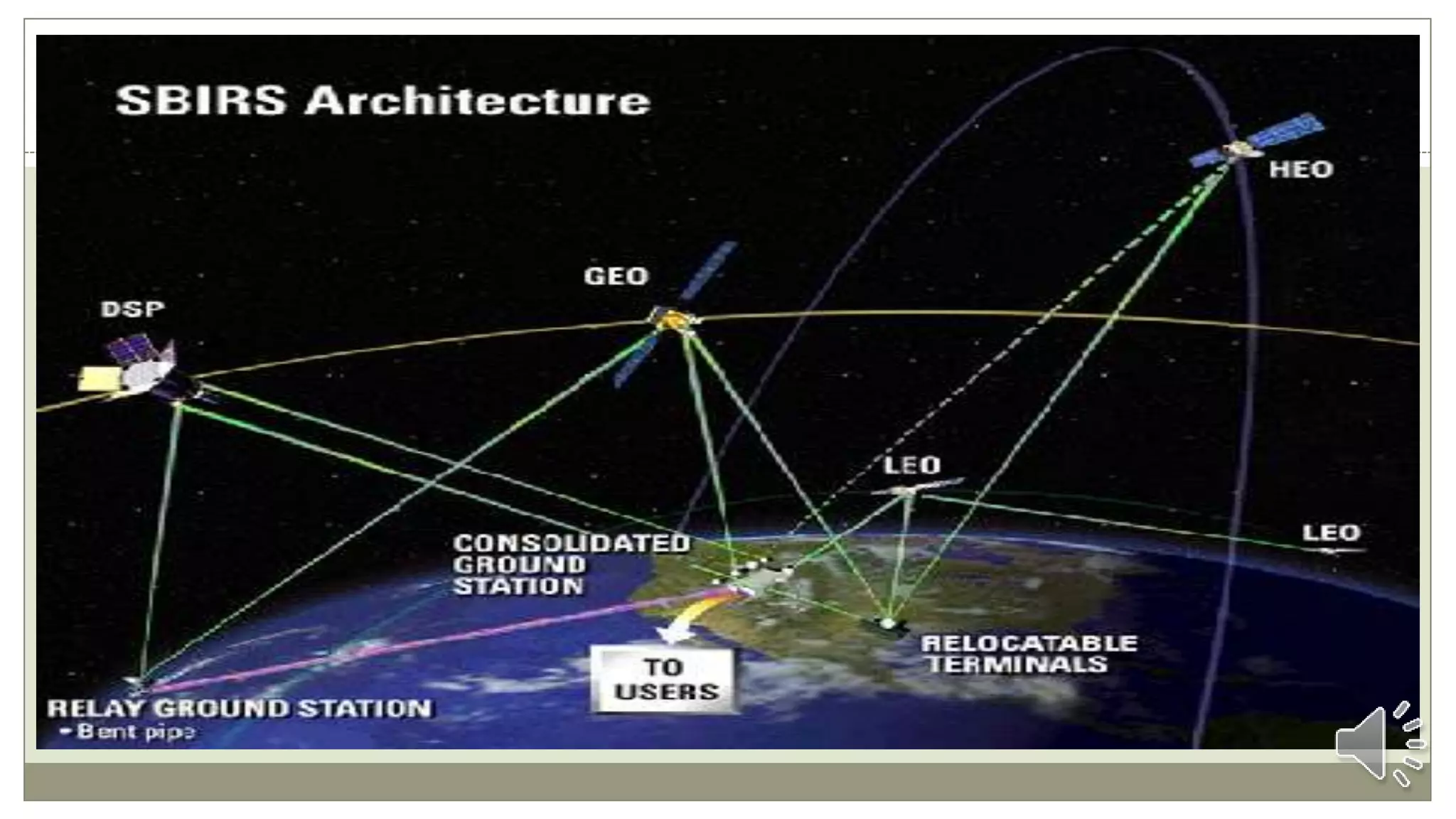
The Space Based Infrared System (SBIRS) is a satellite-based missile warning system developed for the US Air Force. SBIRS includes satellites in geosynchronous orbit and highly elliptical orbit, as well as ground stations. It replaces the Defense Support Program and provides strategic and theater ballistic missile warning capabilities. The SBIRS architecture collects infrared data using sensors on satellites in multiple orbits, which is processed at ground stations to detect missile launches and provide warning information to military and civilian leadership.
Leicester Research Archive (LRA): the work of a repository administratorGaz Johnson
Second part (of three) of a lecture delivered to post graduate library students at the University of Loughborough. Focusses on the role of the repository administrator, and the practical steps taken to populate the site. This section written and presented by Valérie Spezi.
Thank you for all video clips.
https://www.youtube.com/watch?v=HWZXinRwCaE (icbm)
https://www.youtube.com/watch?v=mE-q1IaPIUk (how missiles launch)
https://www.youtube.com/watch?v=SOXmVi3A_PI (satan R36)
https://www.youtube.com/watch?v=LvHlW1h_0XQ (LRASM)
This paper describes about military radar system is going now a days and in future development of the system. How‘s the military operation performed by the radar system. the basically three type of radar are in the radar system , Land based air defense radar , Space borne radar system , ,Airborne surveillance radar .Some conceivable employments of radar information are appeared and how this will improve the adequacy of arranging, planning, coordinating also, controlling of military activities. Vinay Jangir | Manisha Kumawat | Manish Kumar Sharma ""Military Radar System"" Published in International Journal of Trend in Scientific Research and Development (ijtsrd), ISSN: 2456-6470, Volume-3 | Issue-3 , April 2019, URL: https://www.ijtsrd.com/papers/ijtsrd23026.pdf
Paper URL: https://www.ijtsrd.com/engineering/electronics-and-communication-engineering/23026/military-radar-system/vinay-jangir
Location in ubiquitous computing, LOCATION SYSTEMSSalah Amean
This presentation is a simple effort to survey positioning systems which is part o
Introduction
Location system
Global Positioning System
Active Badge
Active Bat
Cricket
UbiSense
RADAR
Place Lab
PowerLine Positioning
ActiveFloor
Airbus and Tracking with Cameras
Credit:
1-the presentation follows the book of "Ubiquitous computing fundamentals by John Krumm " 2010 .
2- few videos are downloaded and integrated with the presentation. Most of the videos are important to explain about each topics they are placed in
AMISR is a modular UHF radar used by scientists and students from around the world to conduct studies of the upper atmosphere and observe space weather events. The modular configuration allows for relocating the radar at different locations around the globe. Remote operation and electronic beam steering allow researchers to operate and position the radar beam on a pulse-to-pulse basis to accurately measure and glean new information from rapidly changing space weather events.
The U.S. Army Research, Development and Engineering Command has the mission to ensure decisive overmatch for unified land operations to empower the Army, the joint warfighter and our nation.
Global Positioning System for College SeminarShaeq Ahmad
Seminar on Global Positioning System
•GPS Segments
•Indian Regional Navigational Satellite System (IRNSS)
•GPS Usage in Palm Jumeirah Archipelago Construction
Tatra, India - All Terrain Vehicles for Indian Armed Forces
Space based infrared system(sbirs), usa one of the nation’s highest priority space programs
1. O N E O F T H E N A T I O N ’ S H I G H E S T P R I O R I T Y
S P A C E P R O G R A M S
Space Based Infrared System, USA
2.
3. Introduction
Lockheed Martin's space based infrared system (SBIRS) is an early warning defense
satellite system being developed for the US Air Force Space Command (AFSPC).
SBIRS is an integrated system of systems that will include satellites in geosynchronous
orbit (GEO), sensors hosted on satellites in highly elliptical orbit (HEO), and ground-
based data processing and control.
SBIRS High will replace the Defense Support Program satellites and is intended primarily
to provide enhanced strategic and theater ballistic missile warning capabilities.
The Mission Control Station (MCS) receives data from all SBIRS sensors and generates
launch reports that include missile type, missile launch point, time, azimuth and
predicted missile impact point.
4.
5. Architecture
SBIRS’ multi-mission, single-platform optimization is the key to its revolutionary capability
The SBIRS architecture consists of hosted sensor payloads in Highly Elliptical Orbit (HEO),
dedicated Geosynchronous Earth Orbiting (GEO) satellites, and the associated ground
infrastructure to receive, process, and deliver the infrared information to key decision makers.
The GEO satellite is equipped with secure communication networks, global positioning system
(GPS) receiver with selective availability anti-spoof module (SAASM), RH-32 radiation-
hardened single board computers and solar flyer attitude control, which is stabilized in three
axes.
There is a distinction between SBIRS-High, and SBIRS-Low, in that satellites at GEO or HEO
are a part of the SBIRS-High system. Satellites in LEO are a part of the SBIRS-Low system.
6.
7. Mission Details
Missile Warning : SBIRS will provide reliable, unambiguous, timely and accurate warning
for theater and strategic missile launches to the President of the United States, the Secretary of
Defense, Combatant Commanders, and other users.
Missile Defense : The system will deliver critical information supporting the effective
operation of missile defense systems against national and theater threats.
Technical Intelligence : SBIRS will provide the ability to characterize infrared (IR) event
signatures, phenomenology, and threat performance data for strategic and operational
combatant commanders, the intelligence community, and others.
Battlespace Awareness : The SBIRS constellation will deliver comprehensive infrared data
to Combatant Commanders, Joint Task Force Commanders and other users to help characterize
battlespace conditions supporting force protection, strike planning and other missions.
8.
9. Payloads
The satellite is equipped with around 1,000lb of infrared sensors equipped with short
Schmidt camera and agile precision pointing and control.
The payloads are also equipped with spacecraft subsystems and a pointing and control
assembly (PCA). Data captured by the payload systems is transmitted to the mission
control station at a rate of 100mbps.
The HEO payloads are hosted in Molniya orbit to assist theatre surveillance missions.
GaAs solar arrays, which produce approximately 2.8kW, are also fitted to the satellites.
10.
11. Ground Segment
The ground segment of SBIRS consists primarily of the Mission Control Station (MCS)
at Buckley AFB, Aurora, Colorado, and the Mission Control Station Backup (MCSB) at
Schriever AFB, Colorado Springs, Colorado. In addition, Joint Tactical Ground
Stations (JTAGS) provide deployable downlinks for SBIRS data.
The Mission Control Station (MCS) receives data from all SBIRS sensors for further
processing and manages the SBIRS constellation.
MCS software generates launch reports that gives thread details.
Air Force Space Command operators review these launch reports and release them to
strategic, tactical, and technical intelligence users around the world.