"Sedimentological studies of Pond deposits from Tista river floodplain, Rangp...Pinaki Sahoo
The Tista River is flowing through Higher Himalaya and Lesser Himalaya lithology and all major lithotectonic boundaries and thrust system of Himalaya. Therefore one important approach to study is sedimentological characteristics of these river sediments reveals source area information.
•Survey on the basic soil properties of Frazer River Sand such as grain size distribution curve, specific gravity, maximum and minimum void ratio, isotropic and anisotropic consolidation behavior, monotonic and cyclic shearing response, specimen preparation, aging and on critical state plasticity model, presenting cone penetration field test data and shear wave velocity measurements.
Reservoir Characterization of “G900” Sandstones Using Wireline Logs and Cores...iosrjce
Wireline logs and cores are analysed to evaluate the quality of reservoir “G900” of Gabo field as
insight for reservoir production optimization planning. “G900” have very good intergranular porosity and
excellent permeability with the main reservoir fluid content as oil and water. “G900” sands are cleaner
towards the North indicating relatively higher play potential. This clay rich subarkosic to arkosic sandstones is
rich in quartz and albite with grain size that is fine to coarse, dominantly poorly sorted, platykurtic to
mesokurtic with symmetrical to fine skewness.. It is a stacked interval of near shore deposits within deltaic
sequences that is rich in ripples and cross stratifications. Effective reservoir development plan of “G900” is
achieved by combining this result with seismic, well test, production data and other geological information to
reduce uncertainties, reveal “G900” lateral extent, compartmentalization, complexities, and fluid quantity for
improved production forecast.
SOIL TEXTURE
SIZE OF THE PARTICLES
HOW THESE PARTICLES CAN BE SEPARATED
TEXTURAL GROUPS
TEXTURAL CLASSES OF SOILS
PROPERTIES
WHY DIFFERENT SOIL TEXTURES HAVE THE PROPERTIES THEY DO ?
ROLE OF SOIL TEXTURE
Geological synthesis excercise in stonehaven using fieldmove app TomAdamson7
The poster was produced using the most recent Fieldmove Clinometer software and Google Earth. Stereonets were produced using Stereonet 10 Software, and Adobe Illustrator was used to create and edit the map and interpretations.
A presentation on the properties and significance of parna deposits in the Yass Valley, NSW, by Dr Richard Greene, ANU, and Peter Fogarty, S&LC Consulting, to Soil Science Australia's Riverina branch workshop on "Parna and Cotton Soils" held at Yanco on 29 April 2021.
The role of deformation bands in modifying reservoir performance in porous sa...TomAdamson7
Report studying the implications of Deformation Bands and their ability to compartmentalise subsurface reservoirs and restrict fluid flow. Paper references recent scientific studies.
Class notes of Geotechnical Engineering course I used to teach at UET Lahore. Feel free to download the slide show.
Anyone looking to modify these files and use them for their own teaching purposes can contact me directly to get hold of editable version.
Over the last decade, demand for spring management has increased as traditional spring sources have started drying up or becoming contaminated. In response, communities, NGOs and state agencies began dedicated spring protection programmes. In the Himalayas, the State of Sikkim and organizations such as Central Himalayan Action and Research Group (CHIRAG) and People Science Institute (PSI) started identifying and protecting spring recharge areas around 2007. The difference between these programmes and many other previous efforts is that they went beyond supply-side improvements to focus on the use of hydrogeology to map springsheds for targeted interventions.
The Advanced Centre for Water Resources Development and Management (ACWADAM), a research and capacity-building organization comprised of hydrogeologists and other experts began lending their expertise and building capacity of stakeholders. ACWADAM provides technical support, training and materials in hydrogeology to all network partners as well as others in India and the region. Similar programmes began independently in most of the mountain regions of India. Arghyam, a funding organization that was supporting many of these programmes, noticed that these disparate initiatives shared commonalities despite geographic diversity. They thus organized and funded a meeting of these various organizations in June 2014, and the Springs Initiative was born.
The springs initiative aims to tackle the current water crisis and to ensure safe and sustainable access to water for all, by promoting responsible and appropriate management of aquifers, springsheds, and watersheds and conserving ecosystems in partnership with communities, governments and other stakeholders.
This presentation has been developed as a part of the springs initiative to promote an understanding of springs and their role in mountainous areas.
Los especialistas siempre están tratando de hacer mejores estimaciones acerca de lo que ocurrirá en el futuro al afrontar la incertidumbre. El propósito fundamental de los pronósticos es hacer buenas estimaciones en las cuales basar los modelos para la toma de decisiones. Los pronósticos constituyen la problemática fundamental dentro de la gestión de la actividad de una empresa debido a la complejidad de los problemas encontrados cuando se pronostica y a su impacto sobre todas las decisiones de la empresa. Una situación muy particular presenta la previsión de la demanda de piezas de repuesto, dada la gran cantidad de surtidos que se deben proporcionar, el elevado grado de variabilidad en la demanda de estas producciones y la importancia que posee la disponibilidad de estas piezas para el equipamiento que las utiliza, ya que la disponibilidad en tiempo de las mismas garantiza la continuidad del proceso productivo en el cual esté inmiscuido el equipamiento que la utiliza dentro de una determinada empresa. Es por ello, que se debe asegurar un elevado nivel de precisión en la previsión de la demanda de este tipo de productos. En este artículo se presenta un procedimiento general para la previsión de la demanda de las piezas de repuesto basado en su fiabilidad operacional a partir de la filosofía que caracteriza al sistema y considerando la influencia del mismo en el mejoramiento de la Gestión del Mantenimiento del equipamiento. Seguimiento de la implantación del procedimiento. En consecuencia, el contenido de cada uno de ellos, plantea los pasos a desarrollar para prever la demanda de piezas de repuesto basado en su fiabilidad, llegándose, en ocasiones, a definir las técnicas específicas a utilizar.
Fiabilidad: es la probabilidad de que un item (sistema o elemento) realice satisfactoriamente la misión especificada, durante un período determinado y bajo un conjunto dado de condiciones operativas.
Patrones de Fallos: Durante décadas, la sabiduría convencional sugería que la mejor forma de optimizar el desempeño de activos físicos era restaurarlos o reponerlos a intervalos fijos. Esto se basaba en la premisa de que hay una correlación directa entre la cantidad de tiempo (número de ciclos) que el equipo está en servicio, y la probabilidad de que falle, como muestra la Figura 2. Esto sugiere que la expectativa es que la mayoría de los ítems operarán confiablemente por un período “X”, y luego se desgastan.
Proceso de mejora de la previsión de la demanda: El procedimiento comienza con la definición de la filosofía, la cual debe ser el punto de mira del sistema ya que constituye la política que regirá permanentemente su desempeño. Luego se realiza la determinación de la situación actual con el fin de definir, basándose en el análisis de una serie de indicadores, las características que presenta el sistema de previsión de la demanda en ese momento, para posteriormente, en función de dicha situación, pr
Artificial Recharge to Alluvial Aquifer, Northeastern Nuba Mountains, Sudan.IJRES Journal
Many engineering geology and structural geology aspects have been used in this study, to point out the suitability of the site for artificial recharge to alluvial aquifer, such as; rocks and soil types, seepage rate, structures and lineaments. The area is under lied by basement rocks with considerable thickness (10 to 15 m) of alluvial deposit. Overall soil type is sandy soil and its seepage rate is 34.56 Liter per hour. The most existing lineaments are trending toward NW direction while rocks foliation dipping toward WWN direction. The site is satisfied to be artificial recharge.
Poster prepared by Tigist Tebebu, Christine Baver, Cathelijne Stoof, and Tammo Steenhuis for the Nile Basin Development Challenge (NBDC) Science Workshop, Addis Ababa, Ethiopia, 9–10 July 2013
International Journal of Engineering Research and Applications (IJERA) is an open access online peer reviewed international journal that publishes research and review articles in the fields of Computer Science, Neural Networks, Electrical Engineering, Software Engineering, Information Technology, Mechanical Engineering, Chemical Engineering, Plastic Engineering, Food Technology, Textile Engineering, Nano Technology & science, Power Electronics, Electronics & Communication Engineering, Computational mathematics, Image processing, Civil Engineering, Structural Engineering, Environmental Engineering, VLSI Testing & Low Power VLSI Design etc.
The study of fine reservoir characterization base on high precision seismic i...iosrjce
According to the potential of fine adjustment in Daqing Oilfield in high water cut stage, this study
meet in dense well network condition more high precision reservoir description requirements. The study area of
reservoir II and III reservoir formation in Saertu oilfield, Daqing oil field is studied. Through the full
investigation of the ideas and methods of the reservoir characterization, this study tries to improve the seismic
attribute resolution by a variety of inversion methods, and thus a set of high accuracy seismic inversion and
prediction of underground real situation is formed. This study first analyzes the reliability of the well seismic
combined with the correlation analysis of the scientific rigorous seismic inversion data and the reservoir log
data. Then in the analysis of various factors to describe the influence of, and combined with the seismic
sedimentology, research ideas, based on high precision seismic inversion to prediction of reservoir sand body
fine then characterize. Has an important guiding significance, tapping the research results on the late stage of
oilfield development.
Classification and Assessment of Soil Compaction Level in Amassoma, Bayelsa S...Premier Publishers
Soil compaction is essential in construction. The failure to displace air from between particles when constructing buildings, roads, parking lots, dams, walls, swimming pools, or utility trench inevitably leads to unwanted soil movement and water penetration into the earth beneath construction projects.Soil compaction is one of the most important aspects of any earthwork construction. Assessing the level of compaction of soil in Amassoma is to ascertain the compatibility or rate of compaction of the underlining earth materials (soils).Nine (9) samples were collected at regular intervals of 1m, 2m, 3m, 4m, 5m, 6m, 7m, 8m and 9m which were used for the analyses. The samples collected were subjected to different laboratory test to determine the index properties and the level of compaction of the soil. Sieve analysis result of the samples shows that the percentage of fines and sands are in the range of 21.57%-63.20% and 36.80% and78.73%, respectively.Atterberg result also shows that the soil liquid limit (LL) is in the range of 48.51%-54.90% plastic limit (PL) ranges from 29/13%-36.51% and 14.78%-25.18% for plastic index (PI). Another experiment shows that the value of maximum Dry Density (MD) and Optimum Moisture Content (OMC) are 1.70g/cm3 and 18 40%. The analysis done for this work reveals that the soil in the area (Amassoma) can be classified as medium to high plastic soil (unified soil classification system) and that the soil in moderately compacted. Comparing the CBR test results with the Nigeria standard, the soils found in Amassoma can be used as sub-grade materials for construction.
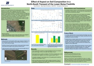
1. Effect of Aspect on Soil Composition in a
North-South Transect of the Lower Boise Foothills
Evan Norman - Boise State University - GEOS 451 - Principles of Soil Science
Future Work:
• In a larger watershed area, clay and gravel percentages may show
stronger trends from the connectivity of higher subsurface flow from
precipitation events and melting.
• Samples taken at shallow depths aimed to remove the interference
of organic matter with measurements of sands, silts, clays and
gravels. With more horizon samples, characterizations of soil
thickness with changes in gravel and texture with distance from
ridgeline could be determined.
• There are many factors affecting field estimates of textural classes
that without experience overestimate sands, silt, or clay. With a
hydrometer particle size analysis completed in a controlled
laboratory setting for this project, human induced error is reduced.
References:
Lower Weather. (2015). Retrieved April 18, 2015, from
http://earth.boisestate.edu/drycreek/data/lower-weather/
Web Soil Survey. (2013). Retrieved April 18, 2015, from
http://websoilsurvey.sc.egov.usda.gov/App/HomePage.htm
Shervais, J.W., Gaurav Shroff, S.K. Vetter, Scott Matthews, B.B. Hanan, an J.J. McGee
(2002) Origin and evolution of the western Snake River Plain: Implications from stratigraphy,
faulting, and the geochemistry of basalts near Mountain Home, Idaho, in Bill Bonnichsen,
C.M. White, and Michael McCurry, eds., Tectonic and Magmatic Evolution of the Snake River
Plain Volcanic Province: Idaho Geological Survey Bulletin V. 30, p. 343-361.
Introduction:
Analysis of soil characteristics with changing aspect can be inferred by
exposure to sunlight, type of vegetation and slope. Further
understanding requires knowledge of pedology and biological,
chemistry, and physical processes. This study analyses how aspect and
hillslope position affect clay and gravel content in a semi-arid watershed
with elevation extremes of 1160 and 1091 meters respectively and 15.4
inches of average annual precipitation (Lower Weather, 2015). I
hypothesized increasing clay and decreasing gravel content on north
aspects, and decreasing clay and increasing gravel content on south
aspects as distance from ridgeline increased.
Methods:
• Along north and south aspects collect auger samples at depths of 15-
30 centimeters over intervals of approximately 35 feet as shown in
Fig. 2, with an AMS soil auger.
• Identify soil class through field textures noting approximate average
clay content and range of clay content per texture found.
• Determine gravel content with #10 soil sieve and the weight ratio of
particles>2mm and total sample collected. Results:
• South slopes show no trend in in clay percentages but have an increased
gravel percentage (>35%) for the latter half transect. (Fig. 3)
• North aspects have a positive correlation, R2=.873 for increasing clay content
with distance from ridgeline, but no trend in gravel content. (Fig. 4)
• Cumulative average for south slopes have 16% greater gravel content by
weight than north slopes. (Fig. 5)
• NRCS and field textures yield 9% higher average composition of clay on
north slopes compared to south slopes with field textures overestimating
published clay compositions by 2%. (Fig. 6)
Discussions and Conclusions:
• Increased moisture content in north facing slopes over south facing
slopes after a drying period, may have led to an overestimation of
clay content during textures analysis.
• Insolation plays an important role in soil moisture and available
water supply. Less exposure on north slopes decreases
evaporation, increases translocation of nutrients through plant
activity and decreases soil particle sizes at shallow auger depths.
Greater solar radiation on south slopes helps explain though a
similar process why we have less plant growth and a higher gravel
percentage. These feedback loops are keys to explain changes in
clay and gravel between N/S aspects.
• Visual evidence of large boulders on the lower south aspect
indicate a parent material of the Idaho batholith while ridgeline
elevations show “lacustrine and deltaic sediments” evidence of a
Pleistocene Lake Idaho (Shervais et al., 2002). This shift in parent
material corresponds to a relatively high gravel content between
250 and 400 feet from the south ridgeline shown in Fig. 3.
Vegetation cover masked any evidence of this on the north aspect.
Contact: evannorman@u.boisestate.edu
Figure 1: Study area location, north-northeast of downtown Boise.
Data:
0
10
20
30
40
50
60
0
10
20
30
40
50
60
70
0 50 100 150 200 250 300 350 400
WeightGravel(%)
Claycontent(%)
Distance from ridgeline (ft)
South Aspect Soil Characteristics 15-30 cm in depth
Clay
Content
Gravel
Content
y = 0.0864x + 9.3333
R² = 0.873
0
5
10
15
20
25
30
35
40
45
0
10
20
30
40
50
60
70
0 50 100 150 200 250 300 350 400
WeightGravel(%)
Claycontent(%)
Distance from ridgeline (ft)
North Aspect Soil Characteristics 15-30 cm in depth
Clay
Content
Gravel
Content
Linear
(Clay
Content)
36%
20%
0%
5%
10%
15%
20%
25%
30%
35%
40%
Average Percent Gravel Weight by Hillslope
Observed South Slope 15-30cm Observed North Slope 15-30cm
17%
26%
15%
24%
0%
5%
10%
15%
20%
25%
30%
35%
Average Percent Clay by Hillslope
Observed South Slope 15-30cm Observed North Slope 15-30cm
NRCS South Slope 0-30cm NRCS North Slope 0-30cm
Research questions:
A. How do clay and gravel contents change with distance from ridgeline?
B. What accounts for N/S changes in clay and gravel content?
Figure 3: Composition of south slopes with error bars for range of clay content for classified field textures.
Figure 4: Composition of north slopes with error bars for range of clay content for classified field textures.
Figure 5: North-south averaged gravel contents
from 12 auger samples on each hillslope.
Figure 6: North-south observed clay contents with
average range of percent clay from field textures
and published NRCS average clay content per
aspect (Web Soil Survey, 2013).
Figure 2: Auger transect locations from each north and south facing ridgeline in the
Lower Boise foothills.