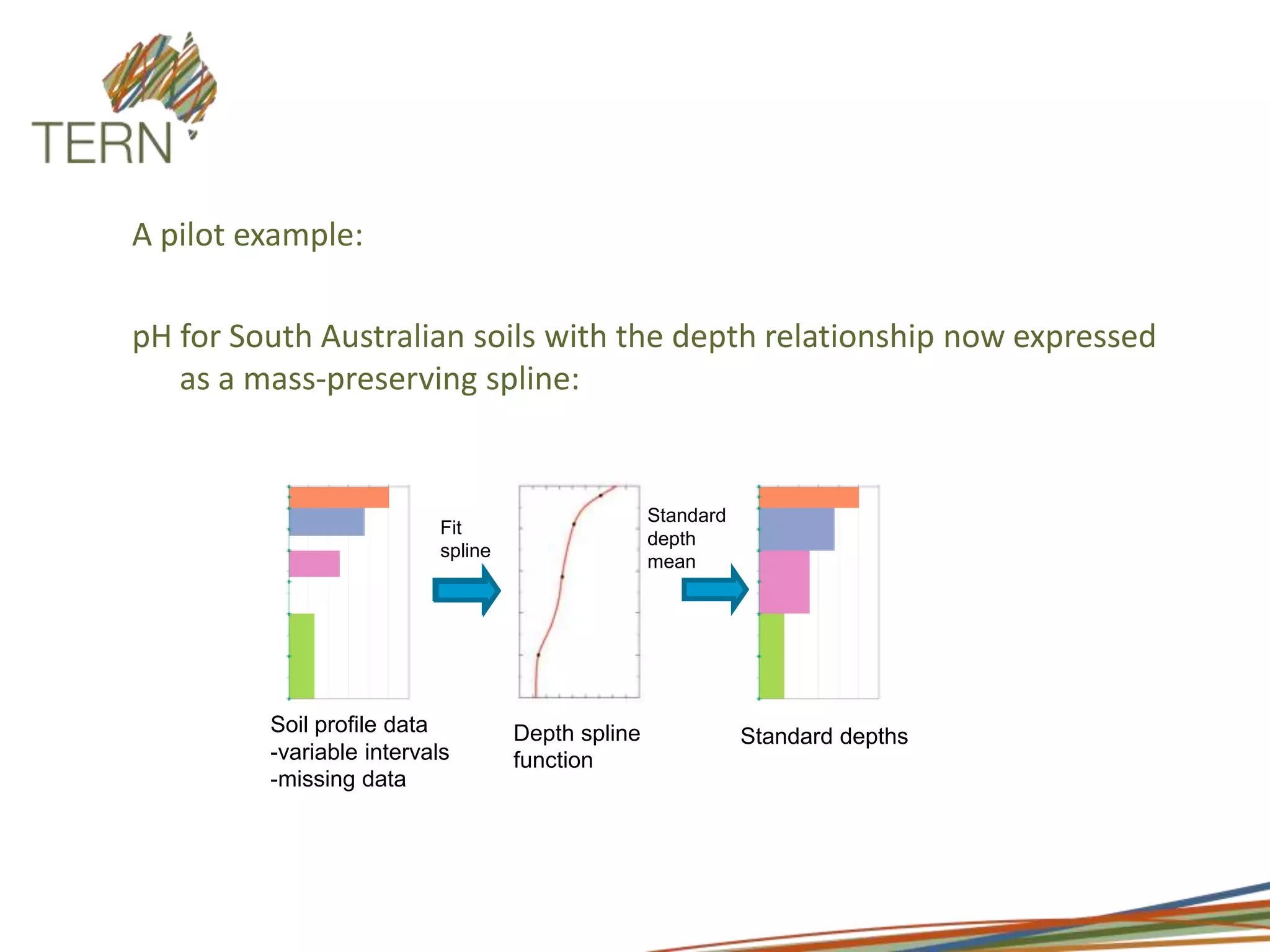
Insert your logo hereSoil and Landscape Grid of Australia Presentation by Mike Grundy, CSIRO
Purpose of FacilityA fine-scale, nationally comprehensive and consistent grid of soil functional attributes – a new form of national soil information which meets the need of ecosystem process and modelling science and which is integrated with developments in earth observation and earth system science.
Key Questions being AddressedHow are the key soil drivers of ecosystem function distributed in space?What is the uncertainty of our estimates of these functions?What is the spatial arrangement of soil attribute depth curves in Australia?What is the representativeness and generality of ecosystems processes observed at a site (with national climate and remote sensing grids)
Infrastructure to be DeliveredGrid-based fine, consistent and comprehensive soil information system at a resolution of 3 arcsec; Mapped estimates of key functional soil attributes (organic carbon, total P, soil texture, coarse fragments, pH, depth to bedrock, effective soil depth, bulk density, available water holding capacity and significant landform elements);Curves of depth relationships of these attributes;Soil covariates including landform and gamma radiometrics;Uncertainty estimates for each attribute expressed as estimation boundsOn-line mapping access
StandarddepthmeanFit splineSoil profile data-variable intervals-missing dataDepth spline functionStandard depthsA pilot example:pH for South Australian soils with the depth relationship now expressed as a mass-preserving spline:
Our plan for community engagementCommunication plan developed with the main project plan	Oversight by National Committee on Soil and Terrain	National Soil Information Symposia – first in late 2011	Informal ad hoc meetings		Interactive web presence (through the ACLEP and ASRIS sites)
Collaborating organisations
AcknowledgementsNational Committee on Soil and Terrain – members from each State and Territory, Universities and Federal Govt
Facility Contact DetailsDirector: Mike Grundy (mike.grundy@csiro.au)	Information contact: Peter Wilson (peter.wilson@csiro.au)	Communications: Claire Harris (claire.harris@csiro.au)

Soils

  • 1.
    Insert your logohereSoil and Landscape Grid of Australia Presentation by Mike Grundy, CSIRO
  • 2.
    Purpose of FacilityAfine-scale, nationally comprehensive and consistent grid of soil functional attributes – a new form of national soil information which meets the need of ecosystem process and modelling science and which is integrated with developments in earth observation and earth system science.
  • 3.
    Key Questions beingAddressedHow are the key soil drivers of ecosystem function distributed in space?What is the uncertainty of our estimates of these functions?What is the spatial arrangement of soil attribute depth curves in Australia?What is the representativeness and generality of ecosystems processes observed at a site (with national climate and remote sensing grids)
  • 4.
    Infrastructure to beDeliveredGrid-based fine, consistent and comprehensive soil information system at a resolution of 3 arcsec; Mapped estimates of key functional soil attributes (organic carbon, total P, soil texture, coarse fragments, pH, depth to bedrock, effective soil depth, bulk density, available water holding capacity and significant landform elements);Curves of depth relationships of these attributes;Soil covariates including landform and gamma radiometrics;Uncertainty estimates for each attribute expressed as estimation boundsOn-line mapping access
  • 5.
    StandarddepthmeanFit splineSoil profiledata-variable intervals-missing dataDepth spline functionStandard depthsA pilot example:pH for South Australian soils with the depth relationship now expressed as a mass-preserving spline:
  • 7.
    Our plan forcommunity engagementCommunication plan developed with the main project plan Oversight by National Committee on Soil and Terrain National Soil Information Symposia – first in late 2011 Informal ad hoc meetings Interactive web presence (through the ACLEP and ASRIS sites)
  • 8.
  • 9.
    AcknowledgementsNational Committee onSoil and Terrain – members from each State and Territory, Universities and Federal Govt
  • 10.
    Facility Contact DetailsDirector:Mike Grundy (mike.grundy@csiro.au) Information contact: Peter Wilson (peter.wilson@csiro.au) Communications: Claire Harris (claire.harris@csiro.au)