
Download to read offline
![Civic Engagement with GIS greatly improved Community Priority Area designations in the SCR Corridor at over 80 public meetings.
2008 Community Priority Areas
This map is for the sole purpose of aiding
regional planning decisions and is not
warranted for any other use. June 2013
“Weir Redevelopment Area”
Priority Development Area (PDA)
City of Taunton
2013 Selected Decision-Making GIS Layers
Industrial Zoning
This map is for the sole purpose of aiding
regional planning decisions and is not
warranted for any other use. June 2013
Business Zoning
2013 Community Priority Areas
This map is for the sole purpose of aiding
regional planning decisions and is not
warranted for any other use. June 2013
“Weir Redevelopment Area [293-14]”
Priority Development Area (PDA)
City of Taunton
MassDEP Wetland Bodies
Wild and Scenic Taunton River
.25 mile
44
.25 mile
44
.25 mile
44
138
138
138
293-14
138
138
former approach
current approach
intra-municipal focus
paper maps presented side by side
general boundaries drawn by hand
inter-municipal and regional focus
layered map data presented interactively
precise and practical boundaries based on relevant geographic information
138](https://image.slidesharecdn.com/sneapafridaye2gis-140205150157-phpapp02/85/SNEAPA-2013-Friday-e2_gis-1-320.jpg)


![2013 Community Priority Areas
This map is for the sole purpose of aiding
regional planning decisions and is not
warranted for any other use. June 2013
“Weir Redevelopment Area [293-14]”
Priority Development Area (PDA)
City of Taunton
.25 mile
44
138
293-14
138](https://image.slidesharecdn.com/sneapafridaye2gis-140205150157-phpapp02/85/SNEAPA-2013-Friday-e2_gis-62-320.jpg)
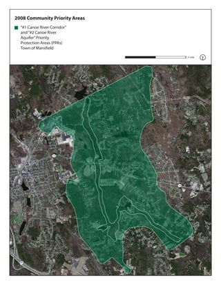

![2013 Community Priority Areas
This map is for the sole purpose of aiding
regional planning decisions and is not
warranted for any other use. June 2013
“Canoe River Zone II Aquifer
[157-08]” and “Canoe River
Greenway [157-07]” Priority
Protection Areas (PPAs)
Town of Mansfield
.25 mile
106
157-08
157-07
106
495](https://image.slidesharecdn.com/sneapafridaye2gis-140205150157-phpapp02/85/SNEAPA-2013-Friday-e2_gis-65-320.jpg)


![2013 Community Priority Areas
“Wareham Village [310-06]”
Priority Development Area
(PDA)
Town of Wareham
“Park Street Historic Area
[310-15]” and “Lower
Narrows Historic Area
[310-013]” Combined
PDA/PPAs
Town of Wareham
This map is for the sole purpose of aiding
regional planning decisions and is not
warranted for any other use. June 2013
“Agawam River [310-07]”
and “Wankinco River
[310-09]” Priority
Protection Areas (PPAs)
Town of Wareham
.25 mile
310-09
28
310-15
310-07
310-06
6
6
6
310-13](https://image.slidesharecdn.com/sneapafridaye2gis-140205150157-phpapp02/85/SNEAPA-2013-Friday-e2_gis-68-320.jpg)


The document summarizes the process of updating community priority areas in the South Coast Rail Corridor region of Massachusetts over a five year period using civic engagement with GIS. Over 80 public meetings were held where community members used over 50 GIS data layers to make clear, data-driven changes to priority areas designations. This resulted in revised priority development areas and priority protection areas being identified on maps and in reports to aid regional planning decisions.


