Savante sdd-200
•
0 likes•90 views
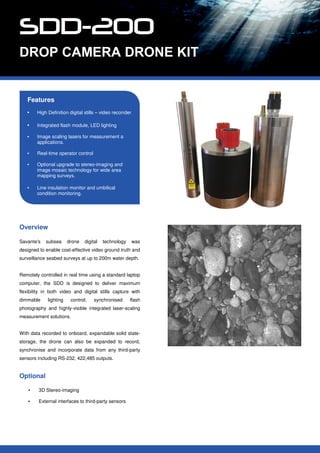
Savante's benthic habitat mapping drop camera inspection kit. The system is designed to be mounted on a drop frame and used to deliver digital video and stills from the seabed. Integrated LED lighting, high performance, fast recycle flash module and laser scaling tools are provided for measurement purposes.
Report
Share
Report
Share
Download to read offline

Recommended
Recommended
For the full video of this presentation, please visit: https://www.edge-ai-vision.com/2021/08/visual-ai-at-the-edge-from-surveillance-cameras-to-people-counters-a-presentation-from-synaptics/
Patrick Worfolk, Senior Vice President and CTO of Synaptics, presents the “Enabling Visual AI at the Edge: From Surveillance Cameras to People Counters" tutorial at the May 2021 Embedded Vision Summit.
New AI-at-the-edge processors with improved efficiencies and flexibility are unleashing a huge opportunity to democratize computer vision broadly across all markets, enabling edge AI devices with small, low-cost, low-power cameras. Synaptics has embarked on a roadmap of edge-AI DNN processors targeted at a range of real-time computer vision and multimedia applications. These span from enhancing the image quality of a high-resolution camera’s output using Synaptics' VS680 multi-TOPS processor to performing computer vision in battery-powered devices at lower resolution using the company's Katana Edge-AI SoC.
In this talk, Worfolk shows how these edge AI SoCs can be used to:
• Achieve exceptional color video in very low light conditions
• De-noise and distortion-correct both 2D and 3D imagery from a time-of-flight depth camera that images through a smartphone OLED display
• Perform super-resolution enhancement of high-resolution video imagery, and
• Recognize objects using lower-resolution sensors under battery power.“Visual AI at the Edge: From Surveillance Cameras to People Counters,” a Pres...
“Visual AI at the Edge: From Surveillance Cameras to People Counters,” a Pres...Edge AI and Vision Alliance
More Related Content
Similar to Savante sdd-200
For the full video of this presentation, please visit: https://www.edge-ai-vision.com/2021/08/visual-ai-at-the-edge-from-surveillance-cameras-to-people-counters-a-presentation-from-synaptics/
Patrick Worfolk, Senior Vice President and CTO of Synaptics, presents the “Enabling Visual AI at the Edge: From Surveillance Cameras to People Counters" tutorial at the May 2021 Embedded Vision Summit.
New AI-at-the-edge processors with improved efficiencies and flexibility are unleashing a huge opportunity to democratize computer vision broadly across all markets, enabling edge AI devices with small, low-cost, low-power cameras. Synaptics has embarked on a roadmap of edge-AI DNN processors targeted at a range of real-time computer vision and multimedia applications. These span from enhancing the image quality of a high-resolution camera’s output using Synaptics' VS680 multi-TOPS processor to performing computer vision in battery-powered devices at lower resolution using the company's Katana Edge-AI SoC.
In this talk, Worfolk shows how these edge AI SoCs can be used to:
• Achieve exceptional color video in very low light conditions
• De-noise and distortion-correct both 2D and 3D imagery from a time-of-flight depth camera that images through a smartphone OLED display
• Perform super-resolution enhancement of high-resolution video imagery, and
• Recognize objects using lower-resolution sensors under battery power.“Visual AI at the Edge: From Surveillance Cameras to People Counters,” a Pres...
“Visual AI at the Edge: From Surveillance Cameras to People Counters,” a Pres...Edge AI and Vision Alliance
Similar to Savante sdd-200 (20)
Vega is a Long Distance Zoom Thermal Infrared Camera Complete turkey key mu...
Vega is a Long Distance Zoom Thermal Infrared Camera Complete turkey key mu...
Anti UAV ADDS Automatic Drone Defense System Jammer RF Radar PTZ Auto Trac...
Anti UAV ADDS Automatic Drone Defense System Jammer RF Radar PTZ Auto Trac...
Thermal Camera Radar VTMS Coastal Surveillance Solution cooled thermal came...
Thermal Camera Radar VTMS Coastal Surveillance Solution cooled thermal came...
“Visual AI at the Edge: From Surveillance Cameras to People Counters,” a Pres...
“Visual AI at the Edge: From Surveillance Cameras to People Counters,” a Pres...
GWT 2014: Emergency Conference - 02 le soluzioni geospaziali per la gestione ...
GWT 2014: Emergency Conference - 02 le soluzioni geospaziali per la gestione ...
Recently uploaded
The study was designed to evaluate the antibacterial potential of three plants which are Andrographis paniculata, Durio zibethinus and Psidium guajava. Andrographis paniculata leaves (30mg/ml) and roots (30 mg/ml), Durio zibethinus wood bark (10mg/ml), and Psidium guajava leaves (15mg/ml) extract was obtained through the process called maceration, filtration, evaporation and the paste form was freshly reconstitute in dimethyl sulfoxide (DMSO) and tested against Staphylococcus aureus for Andrographis paniculata, Psidium guajava. Streptococcus agalactiae for Durio zibethinus and Psidium guajava and Escherichia coli for Durio zibethinus using Kirby Baur technique and the plates were incubated at 37 ºC. The zone of inhibition was measured after 24 hours and recorded in millimeters. The combination study was conducted using extract in combination with Penicillin G (6.25 µg/ ml) and erythromycin (15 µg/ ml; Andrographis paniculata) with the propotion of 1:1 in homogenous condition and incubated at 37 ºC for 24 hours. The zone of inhibition was measured and recorded. Mean and standard deviation was calculated. Andrographis paniculata do possesses some antibacterial activity against Staphylococcus aureus. Leaves (17.33 mm), roots (10.67 mm), erythromycin (24.00 mm), leaves and erythromycin (20.67 mm), roots and erythromycin (21.67 mm), leaves and roots (17.33 mm). Wood bark against Streptococcus agalactiae (14.67 mm), Penicillin G (14.00 mm), and combination (16.67 mm). Durio zibethinus showed antibacterial activity against Escherichia coli (11.00mm) and Penicillin G (13.33 mm). Psidium guajava leaves extract were having slightly higher activity than Penicillin G and in combination activity, leaves were having a slightly higher activity than Penicillin G.
In vitro evaluation of antibacterial activity of chloroform extract Andrograp...
In vitro evaluation of antibacterial activity of chloroform extract Andrograp...Open Access Research Paper
NO1 Pakistan online istikhara for love marriage vashikaran specialist love problem solution astrologer Love marriage specialist baba ji manpasand shadi ka wazifa powerful vashikaran specialist Genuine vashikaran specialist Vashikaran
NO1 Pakistan online istikhara for love marriage vashikaran specialist love pr...
NO1 Pakistan online istikhara for love marriage vashikaran specialist love pr...Amil Baba Dawood bangali
Climate change threatens to reduce not only the quantity of crops, lowering yields, but also the nutritious value. Rising temperatures also mean that more plant pests are appearing earlier and...
Rising temperatures also mean that more plant pests are appearing earlier and...Christina Parmionova
Recently uploaded (20)
In vitro evaluation of antibacterial activity of chloroform extract Andrograp...
In vitro evaluation of antibacterial activity of chloroform extract Andrograp...
A Wide Range of Eco System Services with Mangroves
A Wide Range of Eco System Services with Mangroves
NO1 Pakistan online istikhara for love marriage vashikaran specialist love pr...
NO1 Pakistan online istikhara for love marriage vashikaran specialist love pr...
Introducing Blue Carbon Deck seeking for actionable partnerships
Introducing Blue Carbon Deck seeking for actionable partnerships
2024-05-16 Composting at Home 101 without link to voucher
2024-05-16 Composting at Home 101 without link to voucher
Production, dispersal, sedimentation and taphonomy of spores/pollen
Production, dispersal, sedimentation and taphonomy of spores/pollen
Carbon Stock Assessment in Banten Province and Demak, Central Java, Indonesia
Carbon Stock Assessment in Banten Province and Demak, Central Java, Indonesia
NO1 Best Amil Baba In Pakistan Authentic Amil In pakistan Best Amil In Pakist...
NO1 Best Amil Baba In Pakistan Authentic Amil In pakistan Best Amil In Pakist...
Cooperative Mangrove Project: Introduction, Scope, and Perspectives
Cooperative Mangrove Project: Introduction, Scope, and Perspectives
Up to 40% of food crops are lost to plant pests and diseases annually.
Up to 40% of food crops are lost to plant pests and diseases annually.
Rising temperatures also mean that more plant pests are appearing earlier and...
Rising temperatures also mean that more plant pests are appearing earlier and...
Savante sdd-200
- 1. Features • High Definition digital stills – video recorrder • Integrated flash module, LED lighting • Image scaling lasers for measurement a applications. • Real-time operator control • Optional upgrade to stereo-imaging and image mosaic technology for wide area mapping surveys. • Line insulation monitor and umbilical condition monitoring. Overview Savante's subsea drone digital technology was designed to enable cost-effective video ground truth and surveillance seabed surveys at up to 200m water depth. Remotely controlled in real time using a standard laptop computer, the SDD is designed to deliver maximum flexibility in both video and digital stills capture with dimmable lighting control, synchronised flash photography and highly-visible integrated laser-scaling measurement solutions. With data recorded to onboard, expandable solid state- storage, the drone can also be expanded to record, synchronise and incorporate data from any third-party sensors including RS-232, 422,485 outputs. Optional • 3D Stereo-imaging • External interfaces to third-party sensors