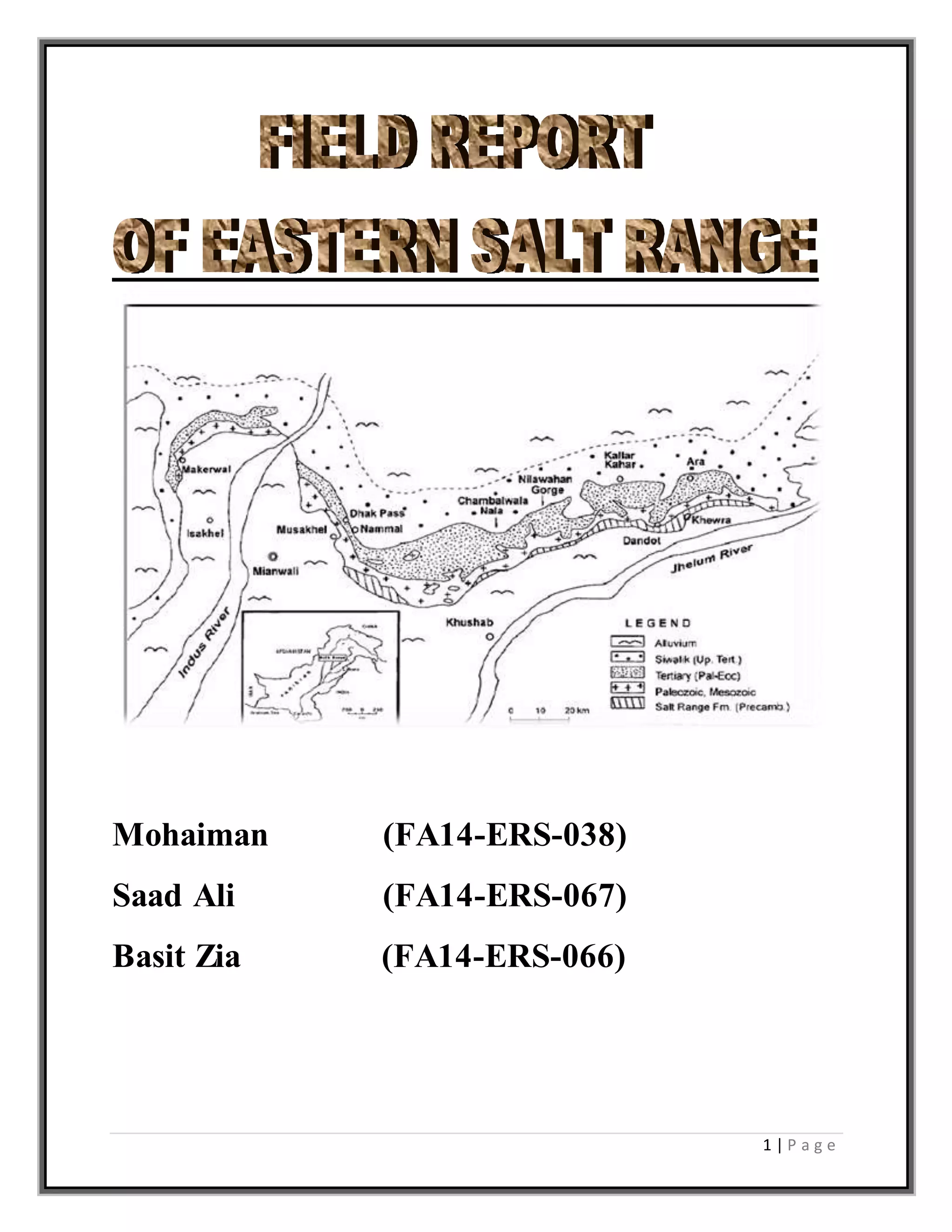
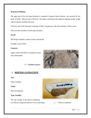
1 | P a g e
Mohaiman (FA14-ERS-038)
Saad Ali (FA14-ERS-067)
Basit Zia (FA14-ERS-066)
2 | P a g e
3 | P a g e
DEDICATION
This report is dedicated to SIR AMJAD BUKHARI and my colleagues who really helped and
appreciated us in making report.
4 | P a g e
ACKNOWLEDGMENT
Many thanks to ALLAH for that was His will and we are able to complete this project.
We extend our sincere and thanks to our course instructor SIR AMJAD BUKHARI for his
continued guidance and never ending support. Without his consistent help it would have
impossible to take this work to the to the level it reached.
5 | P a g e
INTRODUCTION
Objective
Department Of Earth Sciences University Of comsats arranged a field tour for B.s Geology
student of 3rd semester. It was a 4 days field tour. The first day field tour was arranged 30 NOV
2015 to Khewra Gorge and the in these days field tour we studied about the Salt Range area. We
studied different fossil in rocks and the main objective was to study the Stratigraphy of the area.
On first day we visited to Khewra Gorge, here we studied about Salt Range formation and some
other different formations. In Khewra Gorge there is a stream passing through it and the water of
the area is salty in taste. We went through university bus.
Methodology
We applied different methods in our field to recognize the lithology, dipping directions and our
position etc. so these methods are given below:
i. Global Positioning System (GPS) was used for finding the geographical locations of
different stations where we worked.
Brunton Compass was used for measuring the dip and strike of the rocks
.iii. Geological Hammer was used for collecting samples and differentiating between fresh and
weathered surface of rocks. It is also used a scale.
Iv. Hand lens was used for study of fossils and grain sizes
.v. Measuring tape was used to measure different lithologic sections
.vi. Acid was used to easily recognize the lithologies like limestone , dolomites and Weathered
surfaces
6 | P a g e
TABLE OF CONTENT
Chapter 1
Rocks units (stratigraphy)
OBSERVED FORMATION IN SALT RANGE AREA ........................................................................................................................7
I. SALT RANGEFORMATION ........................................................................................................................................................7
II. KHEWRA SANDSTON...............................................................................................................................................................7
III. KUSSAK FORMATION...............................................................................................................................................................7
IV. JUTANA DOLOMITE .................................................................................................................................................................7
V. BAGHANWALAFORMATION.....................................................................................................................................................7
VI. NAMMAL FORMATION ............................................................................................................................................................7
VII. DANDOTFORMATION.........................................................................................................................................................7
VIII. TOBRAFORMATION ...........................................................................................................................................................7
IX. NAGAR PARKER IGNEOUS COMPLEX: .........................................................................ERROR! BOOKMARK NOTDEFINED.
X. KIRANAHILLS...................................................................................................................ERROR! BOOKMARK NOTDEFINED.
I. SALT RANGEFORMATION................................................................................................................................................8
1. Sahwal Marl Member........................................................................................................................................................8
2. BhandarKas Gypsum .........................................................................................................................................................8
3. Billianwala Salt Member: .................................................................................................................................................8
Chapter 2
Structures observed in field
a) Cross bedding…………………………………………………………………………………………………………..17
b) .Ripple marks…………………………………………………………………………………………………………...17.
c) ,Mud cracks ………………………………………………………………………………………………………….,..18.
d) Load casts.......................................................................................................................................................18
e) Salt pseudo morph crystals………………………………………………………………………………………….18.
7 | P a g e
Rocks units (stratigraphy)
OBSERVEDFORMATION IN SALT RANGE AREA
We observed the following formations in Salt Range area in our two days field work.
i. Salt range formation
ii. Khewra Sandston
iii. Kussak formation
iv. Jutana Dolomite
v. Baghanwala formation
vi. Nammal formation
vii. Dandot formation
viii. Tobra formation
Chapter 1
8 | P a g e
i. SALT RANGE FORMATION
Age:
Early Cambrian and late Precambrian and is inactive tectonically.
Name:
Salt Range formation
Type locality:
Khewra gorge eastern salt range Punjab has been designated as the type section.
1. Sahwal Marl Member
It composed of gypseferrous, igneous body called “Khewrite” or “Khewra Trap” pyroxene and oily shale.
The age of the formation has long been a controversial topic. The overlying K hewra
sandstone is of early Cambrian age, therefore the salt range formation is assigned
an Early Cambrian to Late Precambrian age
2. BhandarKasGypsum
The member is composed of massive gypsum with minor beds of dolomite and clay. Massive gypsum
with minor beds of dolomite and clay; (more than 80m)
3. BillianwalaSaltMember:
Dull red marl beds with some salt seem and thick gypsum bed on top. Bright red marl with irregular
gypsum, dolomite beds and Khewra trap.
In Billianwala Salt member, there we observed a cavity which has water dissolved salt. This water
dissolved salt was dropping from ceiling to lower part. The upper water dissolved is called
Stillicitet
e
fig 1.1 StillicTite
9 | P a g e
fig 1.2 Red marl fig 1.3 irregular gypsum Billianwala Salt Member
fig 1.4 Stalagmites
Stalagmites
The lower is called Stillicmite Also this salt is evaporating towards ceiling.
10 | P a g e
Reported Lithology:
The upper part of the salt range formation is composed of gypsum beds, dolomite, clay, greenish & low
grade oil shale; ‘Khewra trap or khewrite’ (6m thick) consisting of decomposed radiating needle of light
colored mineral, probably pyroxene.
The lower part of the formation consisting of Marl, red gypseous with salt consisting of thick seams.
There are three members of Salt range formation
Fossil:
Salt Range formation contains tertiary microfossils.
Example is given below
Contacts:
Upper contact with Khewra sandstone normal
and conforamable.
fig 1.5 Nummulite atacicus
ii. KHEWRA SANDATONE
Age:
Early Cambrian.
Name:
Khewra Sandstone
Type Locality:
The type locality of the Khewra Sandstone
is in Khewra Gorge near Khewra Town, Salt Range. Fig 1.6 Khewra Sandstone
11 | P a g e
Reported Lithology:
The formation predominantly consist of purple brown, yellowish brown fine grained sandstone and the
lower most part of the formation consists of flaggy shale thick to massive bedded ripple marks and mud
cracks . The formation has upper contact with Kussak formation. Thickness at the type locality is about
150m. In the western Salt Range it is about 200m and the exposed thickness in the khisor Range is about
60m. The formation consist a few trace fossils.
Fossil:
It contains Trace fossils and Trilobite trails.
Contacts:
Khewra sandstone has upper contact with Kussak formation and lower contact with Salt Range formation.
iii. KUSSAK FORMATION
Age:
Mid Cambrian and early Cambrian or late early
Cambrian.
Name:
Kussak formation
Type Locality:
The type locality of the formation lies near the
Kussak Fort in the eastern part of the Salt
Range.
Reported Lithology: fig 1.7 glauconitic of Kussak formation
The formation is composed of greenish grey, glauconitic and micaceous sandstone and siltstone
interbedded with light grey dolomite with layer of intraformational conglomerates; pink gypsum lenses at
top and 5.25cm long thin lenses of fossil asphalt (glauconite).
12 | P a g e
iv. JUTANA DOLOMITE
Age:
Early mid Cambrian and late early Cambrian.
Name:
Jutana Dolomite
Type Locality:
The type locality of the formation lies neat the Jutana village in the eastern Salt Range Punjab.
Reported Lithology:
The upper part of the formation consist of light green
to dirty white dolomite, massive; brecceated in upper
part with matrix and fragments of same rocks. The
lower part consist of dolomite of light green color,
hard massive and partly sandy. The formation has
upper contact with Baghanwala formation which is
conformable and the lower contact with Kussak
formation also conformable.
Fossils:
Fig 1.8 Jutana Dolomite
Lingulella fuchsia, botsfordia granulate,redil
chianoetlingi.
v. BAGHANWALA FORMATION
Age:
Mid Cambrian
Name: Baghanwala formation. Fig 1.9: Baghanwala formation
13 | P a g e
Type Locality:
The type section of the Baghanwala formation is located near the Baghanwala village in the eastern Salt
Range.
Reported Lithology:
The formation is composed of red shale and clay alternating with flaggy sandstone of several color pink,
grey or blue green especially in the lower half part. Ripple marks and mud cracks are common. Numerous
pseudomorph cast of salt crystal are present along the bedding plane which are the diagnostic features of
this formation.
vi. DANDOT FORMATION
Age:
Early Permian age.
Name:
Dandot formation
Type Locality:
The type locality of the formation is neat Dandot
village, eastern Salt Range.
Reported Lithology: fig 1.10 Dandot formation
The formation consists of light grey to olive green, yellowish sandstone with occasional thin pebbly and
subordinate dark grey and splintery shale, fossiliferous in the basal part. The maximum thickness of the
formation has been recorded in the Makrach Valley where it is about 50m in thickness.
Fossils:
Dandot formation contains discina, martiniopsois, chonetes, eurydesma, conalaria.
14 | P a g e
vii. TOBRAFORMATION
Age:
Early Permian age.
Name:
Tobra formation
Type Locality: fig 1.11 Pink granite(Tobraformation)
The formation is located near Tobra village in
eastern Salt Range.
The foramation comprises on three facies
Tillitic facies:
The facies exposed in the eastern Salt Range. The
rock unit graded into marine sandstone containing
Eurydesma and Conularia fauna
Reported Lithology:
The Tobra formation is true tillitic; the rock unit is composed of boulders of granite
withfragments of Quartz, feldspar, magnetite, garnet, claystone, siltstone, quartzite,
bituminousshale, diabase and gneiss. Some boulders are polished and scratched. According to
Teichert(1967) ice sheet that formed tillitic deposits is not a part of extensive inland sheet but it
wasresult of local glaciations. The ice sheet did not extend in the area now occupied by central
andwestern salt range. In the central range the Tobra formation is mainly composed of
freshwaterfacies comprising siltstone and shale. The thickness of formation at type locality is 20
meters.
Fossils:
Pollens and spores.
15 | P a g e
viii. KHEWRAIT;
Type Locality:
Eastern salt range
Lithology:
Needle like structures,blackish. It is
sformed dueto igneous activities
Fig 1.13 khewrait
ix. NAGAR PARKER IGNEOUS COMPLEX:
These are the extensions of Indian Shield rocks . It lies in Sindh area in Tharparkar. Kazmi in 1973
proposed the name name Nagar Parker Igneous Complex . It is composed Pink and greyish granite . The
Granite is mainly composed of coarse grained orthoclase and quartz with a few dark minerals and the
greyish granite comprised of orthoclase , plagioclase and quartz with minor amount of hornblende and
magnetite.
x. KIRANA HILLS
Rocks are also extended in different parts of Punjab,. The rocks are predominantly composed
grey slate, red and grey quartzite with mirror amount of conglomerates.
We saw some beddings of limestone in the way that was full of fossils.
AGE;
EOCENE
CORELATION SAKESAR LIME STONE
16 | P a g e
Structures observed in field
The following structures have been observed in the field.
a. Cross bedding
b. Ripple marks
c. Mud cracks
d. Load casts
e. Salt pseudo morph crystals
a. Cross Bedding:
Cross bedding is a feature that occurs at various scales, and is observed in conglomerates and
sandstones. It reflects the transport of gravel and sand by currents that flow over the sediment surface
(e.g. in a river channel). Sand in river channels or coastal environments
b. Ripple Marks:
Ripple marks are produced by flowing water or wave action, analogous to cross-bedding (see
above), only on a smaller scale (individual layers are at most a few cm thick)
Fig 2.1 Ripple marks
Chapter 2
17 | P a g e
c.Mud cracks:
Mud cracks are form when a water rich mud dries out
on the air. You all have seen this when the mud in a
puddle dries out in the day following a rainstorm. Due
to stretching in all directions the mud cracks form a
polygonal pattern. We also see several successive
generation of cracks
Fig 2.2 Mud cracks
d. Load Cast:
Load casts, unlike flute casts, are deformational structures, rather than erosional structures. They
occur commonly along the bases of sandstone beds that overlie mudstone or shale beds. While
they may sometimes resemble flute casts, load casts can be differentiated from flute casts by
their greater irregularity of shape and the lack of any indication of pale flow direction. Load
casts range in size, and may be associated with other deformational structures like flame
structures and/or ball-and-pillow structures. The weight of the overlying sand causes it to sink
unevenly into the muddy substrate, creating these features.
e. Salt Pseudo morph Crystals:
Salt pseudo morphs crystals are secondary minerals that have the forms of the primary mineral
that they replaced. Salt pseudo morphs crystals typically form in the near surface of sediments
because of evaporation of primary salt crystal. Obviously the salt pseudo morphs crystals take on
its natural form and fill a space in the sediments that has form. Later, as the sediments gets
buried further and further, different water can enter the beds containing the salt crystalsso those crystals
will start to dissolve. Often the new water is saturated with silica or carbonates and these minerals
precipitates into the open space once held by the salt crystal, and since that space had the form of original
salt crystal, the quartz or carbonates now has the appearance.
18 | P a g e
CONCLUSION
In the area of our visit sedimentary features are mostly exposed e.g. joints, ripple
marks, fault, fold, salt leeching etc. The format io ns dated from Pre -
Cambrian to Cambrian period. In pre-cambrian period Sahiwal Marl, Bhandar Kas
Gypsum and Billianwala Salt Marl were members of Salt Range Formation, whereas in
Cambrian period Jhelum group includes Baghanwala Formation, Jutana Formation,
Kussak Formation and Khewra Sandstone. We also visited the Khewra salt mine,
where we observed the indoor Brine Ponds and different shades of salt. Interior
embossing of the salt mine increase the interest of the visitors.
s

eastern salt range field report

  • 1.
    1 | Pa g e Mohaiman (FA14-ERS-038) Saad Ali (FA14-ERS-067) Basit Zia (FA14-ERS-066)
  • 2.
    2 | Pa g e
  • 3.
    3 | Pa g e DEDICATION This report is dedicated to SIR AMJAD BUKHARI and my colleagues who really helped and appreciated us in making report.
  • 4.
    4 | Pa g e ACKNOWLEDGMENT Many thanks to ALLAH for that was His will and we are able to complete this project. We extend our sincere and thanks to our course instructor SIR AMJAD BUKHARI for his continued guidance and never ending support. Without his consistent help it would have impossible to take this work to the to the level it reached.
  • 5.
    5 | Pa g e INTRODUCTION Objective Department Of Earth Sciences University Of comsats arranged a field tour for B.s Geology student of 3rd semester. It was a 4 days field tour. The first day field tour was arranged 30 NOV 2015 to Khewra Gorge and the in these days field tour we studied about the Salt Range area. We studied different fossil in rocks and the main objective was to study the Stratigraphy of the area. On first day we visited to Khewra Gorge, here we studied about Salt Range formation and some other different formations. In Khewra Gorge there is a stream passing through it and the water of the area is salty in taste. We went through university bus. Methodology We applied different methods in our field to recognize the lithology, dipping directions and our position etc. so these methods are given below: i. Global Positioning System (GPS) was used for finding the geographical locations of different stations where we worked. Brunton Compass was used for measuring the dip and strike of the rocks .iii. Geological Hammer was used for collecting samples and differentiating between fresh and weathered surface of rocks. It is also used a scale. Iv. Hand lens was used for study of fossils and grain sizes .v. Measuring tape was used to measure different lithologic sections .vi. Acid was used to easily recognize the lithologies like limestone , dolomites and Weathered surfaces
  • 6.
    6 | Pa g e TABLE OF CONTENT Chapter 1 Rocks units (stratigraphy) OBSERVED FORMATION IN SALT RANGE AREA ........................................................................................................................7 I. SALT RANGEFORMATION ........................................................................................................................................................7 II. KHEWRA SANDSTON...............................................................................................................................................................7 III. KUSSAK FORMATION...............................................................................................................................................................7 IV. JUTANA DOLOMITE .................................................................................................................................................................7 V. BAGHANWALAFORMATION.....................................................................................................................................................7 VI. NAMMAL FORMATION ............................................................................................................................................................7 VII. DANDOTFORMATION.........................................................................................................................................................7 VIII. TOBRAFORMATION ...........................................................................................................................................................7 IX. NAGAR PARKER IGNEOUS COMPLEX: .........................................................................ERROR! BOOKMARK NOTDEFINED. X. KIRANAHILLS...................................................................................................................ERROR! BOOKMARK NOTDEFINED. I. SALT RANGEFORMATION................................................................................................................................................8 1. Sahwal Marl Member........................................................................................................................................................8 2. BhandarKas Gypsum .........................................................................................................................................................8 3. Billianwala Salt Member: .................................................................................................................................................8 Chapter 2 Structures observed in field a) Cross bedding…………………………………………………………………………………………………………..17 b) .Ripple marks…………………………………………………………………………………………………………...17. c) ,Mud cracks ………………………………………………………………………………………………………….,..18. d) Load casts.......................................................................................................................................................18 e) Salt pseudo morph crystals………………………………………………………………………………………….18.
  • 7.
    7 | Pa g e Rocks units (stratigraphy) OBSERVEDFORMATION IN SALT RANGE AREA We observed the following formations in Salt Range area in our two days field work. i. Salt range formation ii. Khewra Sandston iii. Kussak formation iv. Jutana Dolomite v. Baghanwala formation vi. Nammal formation vii. Dandot formation viii. Tobra formation Chapter 1
  • 8.
    8 | Pa g e i. SALT RANGE FORMATION Age: Early Cambrian and late Precambrian and is inactive tectonically. Name: Salt Range formation Type locality: Khewra gorge eastern salt range Punjab has been designated as the type section. 1. Sahwal Marl Member It composed of gypseferrous, igneous body called “Khewrite” or “Khewra Trap” pyroxene and oily shale. The age of the formation has long been a controversial topic. The overlying K hewra sandstone is of early Cambrian age, therefore the salt range formation is assigned an Early Cambrian to Late Precambrian age 2. BhandarKasGypsum The member is composed of massive gypsum with minor beds of dolomite and clay. Massive gypsum with minor beds of dolomite and clay; (more than 80m) 3. BillianwalaSaltMember: Dull red marl beds with some salt seem and thick gypsum bed on top. Bright red marl with irregular gypsum, dolomite beds and Khewra trap. In Billianwala Salt member, there we observed a cavity which has water dissolved salt. This water dissolved salt was dropping from ceiling to lower part. The upper water dissolved is called Stillicitet e fig 1.1 StillicTite
  • 9.
    9 | Pa g e fig 1.2 Red marl fig 1.3 irregular gypsum Billianwala Salt Member fig 1.4 Stalagmites Stalagmites The lower is called Stillicmite Also this salt is evaporating towards ceiling.
  • 10.
    10 | Pa g e Reported Lithology: The upper part of the salt range formation is composed of gypsum beds, dolomite, clay, greenish & low grade oil shale; ‘Khewra trap or khewrite’ (6m thick) consisting of decomposed radiating needle of light colored mineral, probably pyroxene. The lower part of the formation consisting of Marl, red gypseous with salt consisting of thick seams. There are three members of Salt range formation Fossil: Salt Range formation contains tertiary microfossils. Example is given below Contacts: Upper contact with Khewra sandstone normal and conforamable. fig 1.5 Nummulite atacicus ii. KHEWRA SANDATONE Age: Early Cambrian. Name: Khewra Sandstone Type Locality: The type locality of the Khewra Sandstone is in Khewra Gorge near Khewra Town, Salt Range. Fig 1.6 Khewra Sandstone
  • 11.
    11 | Pa g e Reported Lithology: The formation predominantly consist of purple brown, yellowish brown fine grained sandstone and the lower most part of the formation consists of flaggy shale thick to massive bedded ripple marks and mud cracks . The formation has upper contact with Kussak formation. Thickness at the type locality is about 150m. In the western Salt Range it is about 200m and the exposed thickness in the khisor Range is about 60m. The formation consist a few trace fossils. Fossil: It contains Trace fossils and Trilobite trails. Contacts: Khewra sandstone has upper contact with Kussak formation and lower contact with Salt Range formation. iii. KUSSAK FORMATION Age: Mid Cambrian and early Cambrian or late early Cambrian. Name: Kussak formation Type Locality: The type locality of the formation lies near the Kussak Fort in the eastern part of the Salt Range. Reported Lithology: fig 1.7 glauconitic of Kussak formation The formation is composed of greenish grey, glauconitic and micaceous sandstone and siltstone interbedded with light grey dolomite with layer of intraformational conglomerates; pink gypsum lenses at top and 5.25cm long thin lenses of fossil asphalt (glauconite).
  • 12.
    12 | Pa g e iv. JUTANA DOLOMITE Age: Early mid Cambrian and late early Cambrian. Name: Jutana Dolomite Type Locality: The type locality of the formation lies neat the Jutana village in the eastern Salt Range Punjab. Reported Lithology: The upper part of the formation consist of light green to dirty white dolomite, massive; brecceated in upper part with matrix and fragments of same rocks. The lower part consist of dolomite of light green color, hard massive and partly sandy. The formation has upper contact with Baghanwala formation which is conformable and the lower contact with Kussak formation also conformable. Fossils: Fig 1.8 Jutana Dolomite Lingulella fuchsia, botsfordia granulate,redil chianoetlingi. v. BAGHANWALA FORMATION Age: Mid Cambrian Name: Baghanwala formation. Fig 1.9: Baghanwala formation
  • 13.
    13 | Pa g e Type Locality: The type section of the Baghanwala formation is located near the Baghanwala village in the eastern Salt Range. Reported Lithology: The formation is composed of red shale and clay alternating with flaggy sandstone of several color pink, grey or blue green especially in the lower half part. Ripple marks and mud cracks are common. Numerous pseudomorph cast of salt crystal are present along the bedding plane which are the diagnostic features of this formation. vi. DANDOT FORMATION Age: Early Permian age. Name: Dandot formation Type Locality: The type locality of the formation is neat Dandot village, eastern Salt Range. Reported Lithology: fig 1.10 Dandot formation The formation consists of light grey to olive green, yellowish sandstone with occasional thin pebbly and subordinate dark grey and splintery shale, fossiliferous in the basal part. The maximum thickness of the formation has been recorded in the Makrach Valley where it is about 50m in thickness. Fossils: Dandot formation contains discina, martiniopsois, chonetes, eurydesma, conalaria.
  • 14.
    14 | Pa g e vii. TOBRAFORMATION Age: Early Permian age. Name: Tobra formation Type Locality: fig 1.11 Pink granite(Tobraformation) The formation is located near Tobra village in eastern Salt Range. The foramation comprises on three facies Tillitic facies: The facies exposed in the eastern Salt Range. The rock unit graded into marine sandstone containing Eurydesma and Conularia fauna Reported Lithology: The Tobra formation is true tillitic; the rock unit is composed of boulders of granite withfragments of Quartz, feldspar, magnetite, garnet, claystone, siltstone, quartzite, bituminousshale, diabase and gneiss. Some boulders are polished and scratched. According to Teichert(1967) ice sheet that formed tillitic deposits is not a part of extensive inland sheet but it wasresult of local glaciations. The ice sheet did not extend in the area now occupied by central andwestern salt range. In the central range the Tobra formation is mainly composed of freshwaterfacies comprising siltstone and shale. The thickness of formation at type locality is 20 meters. Fossils: Pollens and spores.
  • 15.
    15 | Pa g e viii. KHEWRAIT; Type Locality: Eastern salt range Lithology: Needle like structures,blackish. It is sformed dueto igneous activities Fig 1.13 khewrait ix. NAGAR PARKER IGNEOUS COMPLEX: These are the extensions of Indian Shield rocks . It lies in Sindh area in Tharparkar. Kazmi in 1973 proposed the name name Nagar Parker Igneous Complex . It is composed Pink and greyish granite . The Granite is mainly composed of coarse grained orthoclase and quartz with a few dark minerals and the greyish granite comprised of orthoclase , plagioclase and quartz with minor amount of hornblende and magnetite. x. KIRANA HILLS Rocks are also extended in different parts of Punjab,. The rocks are predominantly composed grey slate, red and grey quartzite with mirror amount of conglomerates. We saw some beddings of limestone in the way that was full of fossils. AGE; EOCENE CORELATION SAKESAR LIME STONE
  • 16.
    16 | Pa g e Structures observed in field The following structures have been observed in the field. a. Cross bedding b. Ripple marks c. Mud cracks d. Load casts e. Salt pseudo morph crystals a. Cross Bedding: Cross bedding is a feature that occurs at various scales, and is observed in conglomerates and sandstones. It reflects the transport of gravel and sand by currents that flow over the sediment surface (e.g. in a river channel). Sand in river channels or coastal environments b. Ripple Marks: Ripple marks are produced by flowing water or wave action, analogous to cross-bedding (see above), only on a smaller scale (individual layers are at most a few cm thick) Fig 2.1 Ripple marks Chapter 2
  • 17.
    17 | Pa g e c.Mud cracks: Mud cracks are form when a water rich mud dries out on the air. You all have seen this when the mud in a puddle dries out in the day following a rainstorm. Due to stretching in all directions the mud cracks form a polygonal pattern. We also see several successive generation of cracks Fig 2.2 Mud cracks d. Load Cast: Load casts, unlike flute casts, are deformational structures, rather than erosional structures. They occur commonly along the bases of sandstone beds that overlie mudstone or shale beds. While they may sometimes resemble flute casts, load casts can be differentiated from flute casts by their greater irregularity of shape and the lack of any indication of pale flow direction. Load casts range in size, and may be associated with other deformational structures like flame structures and/or ball-and-pillow structures. The weight of the overlying sand causes it to sink unevenly into the muddy substrate, creating these features. e. Salt Pseudo morph Crystals: Salt pseudo morphs crystals are secondary minerals that have the forms of the primary mineral that they replaced. Salt pseudo morphs crystals typically form in the near surface of sediments because of evaporation of primary salt crystal. Obviously the salt pseudo morphs crystals take on its natural form and fill a space in the sediments that has form. Later, as the sediments gets buried further and further, different water can enter the beds containing the salt crystalsso those crystals will start to dissolve. Often the new water is saturated with silica or carbonates and these minerals precipitates into the open space once held by the salt crystal, and since that space had the form of original salt crystal, the quartz or carbonates now has the appearance.
  • 18.
    18 | Pa g e CONCLUSION In the area of our visit sedimentary features are mostly exposed e.g. joints, ripple marks, fault, fold, salt leeching etc. The format io ns dated from Pre - Cambrian to Cambrian period. In pre-cambrian period Sahiwal Marl, Bhandar Kas Gypsum and Billianwala Salt Marl were members of Salt Range Formation, whereas in Cambrian period Jhelum group includes Baghanwala Formation, Jutana Formation, Kussak Formation and Khewra Sandstone. We also visited the Khewra salt mine, where we observed the indoor Brine Ponds and different shades of salt. Interior embossing of the salt mine increase the interest of the visitors. s