Downloaded 88 times


![33
Marine (Open Deltaic)
Permo-Triassic Boundary
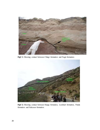
It is marked by contact between Chidru and Mianwali. And it is a major unconformity.
It is a Paraconformity.
The Permian–Triassic (P–Tr) extinction event, colloquially known as the Great Dying,
occurred about 252 Ma (million years) ago, forming the boundary between the Permian
and Triassic geologic periods, as well as the Palaeozoic and Mesozoic eras. It is the
Earth's most severe known extinction event, with up to 96% of all marine species and
70% of terrestrial vertebrate species becoming extinct. It is the only known mass
extinction of insects. Some 57% of all families and 83% of all genera became extinct.
Because so much biodiversity was lost, the recovery of life on Earth took significantly
longer than after any other extinction event,] possibly up to 10 million years.
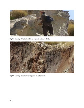
Tredian Formation
Type Locality:
Not designated, Ref sections are: Zaluch Nala western Salt Range & Tappan Wahan, Khisor
Range.
Lithology:
On our field we observed purplish sandstone, it was not well exposed under our region of study,
and there was a thick band, though we found a boulder of it that was purplish, is soft when
touched.
Fossils:
No fossils were observed by us here.
Age :
Middle Triassic
Contacts:
Upper contact is conformable with Kingriali formation and lower is conformable with
Mianwali formation.](https://image.slidesharecdn.com/fieldreportbysamikhanzadran-160322175336/85/Salt-Range-field-Report-By-Samiullah-33-320.jpg)


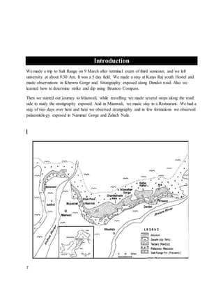
The document is a detailed field report on a geological trip to the Salt Range, documenting various formations, observations, and measurements taken over five days. It highlights significant geological and paleontological features, including fossil-rich stratified rocks and different formations like the Sakesar limestone and Khewra formation. The report serves as an educational overview of the geology in the region, aimed at understanding its stratigraphy and tectonic features.


![Polymer [ बहुलक ] Chemistry Notes PDF - Irfanullah Mehar - JJ Sir Chemistry.pdf](https://cdn.slidesharecdn.com/ss_thumbnails/polymerchemistrynotespdf-irfanullahmehar-jjsirchemistry-260210172118-3f9b37f7-thumbnail.jpg?width=640&height=640&fit=bounds)


