
Recommended
More Related Content
Similar to BS-II Kohat.ppt
Similar to BS-II Kohat.ppt (20)
Recently uploaded
Recently uploaded (20)
BS-II Kohat.ppt
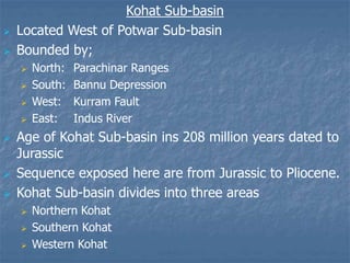
- 1. Kohat Sub-basin Located West of Potwar Sub-basin Bounded by; North: Parachinar Ranges South: Bannu Depression West: Kurram Fault East: Indus River Age of Kohat Sub-basin ins 208 million years dated to Jurassic Sequence exposed here are from Jurassic to Pliocene. Kohat Sub-basin divides into three areas Northern Kohat Southern Kohat Western Kohat
- 2. Northern Kohat (Panoba Section) 9. Lei Conglomerate 8. Siwalik Group 7. Rawalpindi Group 6. Kohat Formation 5. Kuldana Formation 4. Sheikhan Limestone 3. Panoba Shale 2. Patala Formation 1. Lockhart Formation Southern Kohat (Bahadhurkhel Section) 9. Lei Conglomerate 8. Siwalik Group 7. Rawalpindi Group 6. Kohat Formation 5. Kuldana Formation 4. Jatta Gypsum 3. Bahadhurkhel Salt 2. Patala Formation 1. Lockhart Formation Western Kohat (Samana Range) 5. Hangu Formation 4. Kawagarh Formation 3. Lunshiwal Formation 2. Chichali Formation 1. Samana Suk Formation Overall Sequence Lei Conglomerate Siwalik Group Rawalpindi Group Kohat Formation Kuldana Formation Jatta Gypsum / Sheikhan Limestone Bahadhurkhel Salt / Panoba Shale Patala Formation Lockhart Formation Hangu Formation Kawagarh Formation Lunshiwal Formation Chichali Formation Samana Suk Formation
- 3. Samana Suk Formation As discussed under Salt Range. --------------------------------------------- Surghar Group Contains the following formation, the type section for these formation is in the Surghar Range. But these are also exposed in the Kohat Sub-basin. Formations are of Cretaceous age; 1. Chichali Formation 2. Lumshiwal Formation 3. Kawagarh Formation
- 4. 1. Chichali Formation Chichali term was introduced by Danichik 1961 and Danilchik et al 1967 For; Beleminites beds of Spatt 1939 and Gee 1945 in Surghar Range Spiti Shale of Middlemiss 1896 and Cotter 1933 in Kalachitta Range Type Locality Chichali Pass, Surghar Range (lat. 330 00’ 00’’ N and 700 25’ 00’’ E) Lithology Sandstone+Shale Over all formation having dark green, greenish grey, sandy silty, weather rusty brown glauconitic sandstone and shale interbeds Shale and sandstone have phosphatic nodules and pyrite, shale may be carbonaceous at places.
- 5. Thickness/Distribution Well distributed in Trans Indus Ranges, Kala Chitta Range, Hazara and Kohat areas. At type locality, thickness varies 55-70m In western Kohat (Samana Range) 15-20m In Kala Chitta Ranges 12-27m Hazara area 33m Fossils Abundant beleminites, in sandstone, bivalves and ammonites are also present. Age Early-Cretaceous Contact Lower: conformable with Samana Suk Formation Upper: Gradational with Lumshiwal Formation Environment of Deposition Shallow Marine (Shelfal)
- 6. 2. Lumshiwal Formation Gee 1945 proposed the name Lumshiwal Sandstone then Stratigraphic Committee of Pakistan Formalized the name Lumshiwal Formation for the; Giumal Sanstone of Middlemiss 1896 and Cotter 1933 Mari Sanstone series of Davies 1930 at Hazara Kala Chitta and Kohat area. Type Locality/Section Name derived from Lumshiwal Nala (lat. 320 05’ 00’’ N and long. 710 09’ 00’’ E) The type section lies 1km from Lumshiwal Nala by Fatmi 1977.
- 7. Lithology Shale+Sandstone+Limestone At type locality Shale: silty and sandy, glauconitic shale at the base Sandstone: thick bedded, light grey, current bedded sandstone, sandstone is feldspathic, ferruginous and contains carbonaceous material in upper part Samana, Hazara, Kala Chitta Ranges Sandstone have interclation of Limestone; rusty brown and sandty with abundant fossils of echinoderm and forams etc. Thickness/Distribution Trans Indus Ranges, Kala Chitta, Kohat, Hazara Thickness at type locality 80-120m Chichali pass 38m Samana Range 194m SE Hazara 50m
- 8. Fossils Beleminites, ammonites, gastropods, echinoderms, brachiopods etc. Age Middle Cretaceous Contact Lower: gradationla Chichali Formation Upper: conformable with Kawargh Formation Environment of Deposition Shallow Marine
- 9. 3. Kawagarh Formation The name was introduced by Day A. as Kawagarh Marl Stratigarphic Committee of Pakistan approves it to be Kawagarh Formation Before that various workers has given various name at various places as; Sub-lithographic limestone in Samana Range by Davies 1930 Darsamand Limestone in W. Kohat by Fatmi and Khan 1966 Dunbar Limestone by Khan and Ahmad 1966; Sattu Limestone by Calkins and Martin 1968; Chanali Limestone by Latif 1970, in Hazara area. Type Locality After Kawagarh Hills, North of main Kala Chitta Range in Attock district (lat 330 45’ 30’’ N and long. 700 28’ 30’’ E)
- 10. Lithology At type locality Consists of dark marl with calcareous shales weathers into light grey, brownish grey and argillaceous limestone. In Western Kohat Formation is divisible into two member Upper: Tsukail Tsuk Limestone Named after Tsukail Tsuk Peak, North of Darsamand (lat. 330 28’ 33’’ N, long. 700 38’ 09’’ E) A grey, sub-lithographic, thick bedded, escarpment forming, limestone with common smaller forams. Lower: Chalor Silli Member Named after Chalor Silli Village, Samana range (lat. 330 26’ 25’’ N, 700 38’ 16’’ E) A light grey, olive grey, lithographic to sub-lithographic, thin-medium bedded limestone with subordinate calcareous shale and marl interclation with smaller forams and rare ammonites. In Eastern Kohat Dolomitic limestone occurs at lower part
- 11. Hazara area The formation is typically a thin to thick bedded limestone similar to W. Kohat but there is another member; Nara Sandstone Member: Named after the village Nara, SE Hazara (lat. 350 59’ 00’’ N, long. 730 13’ 30’’ E) Member having grey, brownish grey to dark grey, thick bedded, calcareous with some limestone interbeds. Thickness/Distribution In eastern Kohat 70-90m In western Kohat 110m In Kala Chitta (type locality) 40-70m Hazara varies 45-200m Fossils Small forams, corals, poorly preserved ammonoids Age Late Cretaceous Contact Lower: conformable with Lumshiwal Formation Upper: disconformable with Hangu Formation Environment of Deposition Marine (Open)
- 12. Makarwal Group As done in the Salt Range -------------------------------------------- Eocene Stratigraphy of Kohat Area (Cherat Group ) Includes the following formation Kohat Formation Kuldana Formation Jatta Gypsum / Sheikhan Limestone Bahadhur Khel Salt / Panoba Shale
- 13. 1. Bahadhurkhel Salt Kohat Saline series by Gee in 1945 Bahadhurkhel Salt was introduce by Meisner 1968 Type Locality Bahadhurkhel salt quarry (lat. 330 09’ 54’’ N, long. 700 59’ 53’’ E) Lithology Salt: white with black stringers at places At other places: dark grey to black Thickness/Distribution Outcrop at Bahadhurkhel is about 12km in length and half km wide. Thickness at type locality is 480m Fossils Only plant leaves Age Early Eocene (Superposition)
- 14. Contact Lower: conformable with Patala Formation Upper: conformable with Jatta Gypsum Environment of Deposition Evaporitic ----------------------------------------------------- 2. Jatta Gypsum Jatta Gypsum by Meisner 1968 For upper part of Kohat series of Gee 1945 Type Locality Jatta Gypsum quarry (lat. 330 18’ 00’’ N and long. 710 17’ 00’’ E) Lithology Gypsum: greenish, white in colour, massive bedded, hard having interclation of clay of red, green at different intervals
- 15. Thickness/Distribution Jatta Gypsum covers an area in southern kohat about 130km long and 15-30km wide Thickness ranges form 25-40m Fossils No fossil have been reported Age Early Eocene (due to superposition) Environment of Deposition Evaporitic
- 16. 3. Panoba Shale Term introduced by Eames 1952 Green clay by Wynne 1879 Green shale by Pascoe 1926 Green clay and sandstone by Gee 1934 Type Locality/Section The section is exposed south of Panoba village (lat. 330 37’ 00’’ N and long. 710 35’ 00’’ E) Lithology Shale with subordinate sandstone Shale: colour is olive green, greenish grey and calcareous towards base Thickness/Distribution Only confined to Kohat area Thickness at type locality 100m, Tarkhobi 40m and Uch Bazar 160m
- 17. Fossils Microfossils like ostracodes, forams, mollusks Age Early Eocene Contact Lower: conformable with Patala Formation Upper: conformable with Sheikhan Formation (Panoba Section) unconformable with Kohat Formation at Utch Bazar Environment of Deposition Shallow Marine
- 18. 4. Sheikhan Formation Sheikhan Limestone by Davies 1926 Gypsiferous beds of Eames 1952 Formalized by Stratigraphic Committee of Pakistan as Sheikhan Formation Type Locality The section is exposed in Sheikhan Nala (lat. 330 35’ 00’’ N and long. 710 30’ 00’’ E) Lithology At type locality Limestone with subordinate shale Limestone is yellowish grey, thin bedded, nodular Shale is gypsiferous at the top of the formation At Panoba Section Limestone with subordinate shale at lower part While argillaceous limestone interclated with dusky brown shale with gypsum beds near at top
- 19. Fossils Forams, mollusks, echinoids, and corals Age Early Eocene Contact Lower: conformable with Panoba Shale Upper: conformable with Kuldana Formation Environment of Deposition Shallow Marine
- 20. 5. Kuldana Formation Kuldana beds by Wynne 1874 Kuldana series by Middlemiss 1896 Varigated shale by Pinfold 1918 Lower cherat by Eames 1952 Mamikhel Clay by Meisner 1968 Kuldana beds by Latif 1970 Formalized by Stratigraphic Committee of Pakistan as Kuldana Formation Type Locality Village Kuldana at lat. 330 56’ N and long. 730 27’ E, north of Murree Hill Station Lithology Shale; with crimson red, purple, brown buff, pale yellow in colour and marl; with brown buff with few beds of gypsum and occasional beds of sandstone, limesotne conglomerate with little dolomite Hazara area Formation is mainly composed of Shale and Marl Kala Chitta Mainly shale Kohat Area Predominantly limestone, sandstone, dolomite
- 21. Thickness/Distribution Hazara, Kala Chitta, Kohat area; 150m Fossils Forams, gastropods, bivalves, vertebrate fossils Age Early to Middle Eocene Contact Lower: conformable with Sheikhan Formation Upper: conformable with Kohat Limestone Environment of Deposition Shallow Marine
- 22. 6. Kohat Formation Eames 1952 named this formation as Kohat Shales and divided it into three units as’ Nummulitic Shales Kohat Limestone Sirki Shales Stratigraphic Committee of Pakistan approved this formation to be Kohat Formation with three subdivision of Meisner as; Kaladandh Member Sadkal Member Habib Rahi Member Type Locality Kohat-Khushalgarh Highway at lat. 330 27’ N and long. 710 35’ E. Lithology Subordinatng Limestone and shale Mainly divided into three members as;
- 23. a. Kaladandh Member The lower member, having limestone of light grey, hard massive with shale and fossiliferous b. Sadkal Member Middle one, having shale greenish grey, calcareous with subordinate limestone. c. Habib Rahi Member Upper one, having limestone interbedding are dominated in kohat area and highly fossiliferous in Nummulites also called as Nummulitic Limestone. Thickness/Distribution 130m at Utch Bazar, 50m Mamikhel, 170m at Chilli Bagh. Fossils Forams abundant, mollusks
- 24. Age Early to middle Eocence Contact Lower: conformable with Kuldana Formation Upper: unconformable with Murree Formation Environment of Deposition Shallow Marine (Shelfal)
- 25. Rawalpindi Group of Miocene age, Siwalik Group of Pliocene age and Lei conglomerate has already been discuss in detail -----------------------------------------------------