SlideShare a Scribd company logo
1 of 7
Download to read offline
Introduction:
About 70 km south of the main Himalayan Ranges, the Salt Range was raised due to
Main Frontal Thrust (MFT) as a 180-km-long and 85-km-wide ridge of hills at the southern
edge of the Potwar Basin Pakistan. MFT, which is associated with salt range, also called Salt
Range Thrust (SRT). Salt range is widest in its central part, between the Khewra and the
Warchha where it also contains the best exposures of Palaeozoic and Precambrian
sequences. All the strata are excellently exposed due to lack of vegetation. The quality of
the exposure also provides excellent opportunities to appreciate tectonic features in the
field. The Salt Range is, therefore, of international scientific and educational value, and is
highly worthy of conservation and preservation.
Figure 1-Fig. 1 Location map of the Salt Range in northern Pakistan
The name Salt Range was first used by Elphinston in 1808. He visited this territory (1808–
1815) and noticed the extraction of salt from the Salt Range. Hence, historically, the Salt
Range derives its name after the occurrence of gigantic deposits of rock salt embedded in
the Precambrian bright red marls that are stratigraphically known as the Salt Range
Formation (formerly Punjab Saline Series). Apart from the easily available roadside geology,
here are some prominent gorges cutting the Salt Range. Among these gorges, we have
visited Khewra, Chichali, Zaluch, and Nammal gorge, which provide the fantastic locations to
study the sediment
Figure 2-Generalized exposed stratigraphic units with major breaks in deposition in
the Salt Range, Pakistan
The Salt Range contains wealth of geological features, for which it has been rightly called
as the “Field Museum of Geology.” Because it has all the sedimentary sequence right from
Precambrian upto Eocene. In fact, it represents an open book of geology, where the richly
fossiliferous stratified rocks such as the Permian carbonate succession contains brachiopod
fauna with conodont biostratigraphy and foraminifera biostratigraphy. We also have
collected different Traces and fossils of Trilobites, Bracheopods, Cephalopods, Forms, etc
from the field.
Salt range is divided into three parts namely eastern, central and western. At eastern side
older and at western side mostly younger rocks have been exposed. In our field visit, we
have studied stratigraphy of eastern, western (Salt range) and part of Trans-Indus ranges
(Surghar range).
➢ EASTERN SALT RANGE (from Jogi Tilla to Nilawahan)
➢ WESTERN SALT RANGE (From Nilawahan to Warchha Mandi)
➢ CENTRAL SALT RANGE (From Warchha Mandi to Mari Indus)
Economically salt range is very important for their 2nd largest salt mine in the world. large
deposits of high grade Gypsum and Anhydrites, an important calcium minerals, are found
Figure 3-a Schematic illustration of the three subdivisions of the Salt Range (modified after Gee and Gee 1989). b Generalized map
showing major structural trends in different parts of the Salt Range
here in salt range. Beside gypsum, anhydrides and medium grade coal, pink salt of salt range
is also very famous all over the world. Pakistan export pink salt of salt range to different
countries of the world.
Regional tectonics of the Salt Range
About 50 millions years ago Indian plate collide with Eurasian plate formed the gaint
Himalayas. Due compressive stresses (collision) many thrust faults were produced namely,
Main Karakurrum Thrust, Main Mentle Thrust, Main Boundry Thrust and Main Frontal
Thrust. Main Frontal thrust that is associated with salt range is called Salt Range Thrust. Due
to SRT Salt Range were uplifted. The Salt Range is truncated along the southern margin by
Salt Range Frontal Thrust (SRFT), which is bounded between Jehlum and Indus River. It has
pushed the older successions of the Salt Range upon the less deformed tertiary sequences
of the south lying in the Punjab Plain. The thrust zone is largely covered by Recent
conglomerates and Jehlum River alluvium. However, near the Kalabagh area, the thrust is
exposed and shows the Palaeozoic rocks overlying the Neogene or Quaternary deposits of
the Punjab Plain. At eastern side of the salt range more older (Precambrian) rocks are
exposed as compared to western (younger) salt range which shows the strength of stresses
that have been applied on this area. We can also trace back the collision behavior of indo-
Figure 4-Generalized regional tectonic map of the Salt Range, Pakistan (modified after Kazmi and Rana 1982)
eurasion plates collision from the folding and faults that are present in Salt Range. The Salt
Range is thus the surface expression of the leading edge of the decollement thrust.
Jehlum fault (left handed strike slip fault) marks eastern boundary of the Salt Range, and at
western side, Kalabagh fault (Right handed strike slip fault) marks the western limit of Salt
Range.
The Salt Range is structurally very complex and consists of three basic structural styles: (1)
compressional deformation (thrusting and folding), (2) transform deformation (strike faults),
and (3) extensional deformation (normal faults).
Location of Salt Range
Salt Range is located in Indian plate at upper Indus basin of Pakistan, with having
east west trending. Salt range is a mountain range of punjab province. Salt Range lies
between the valley of Indus and Jehulum river in Punjab province of Pakistan. The range has
a length of 180 km and it is highest peak is Sakesar which is approximately 1,600 m. Location
of Salt Range can be defined by two ways.
1. On the basis of faults
2. On the basis of geographic view
North
Kala Chitta
Range
Potwar Basin
Soan Basin Murree
Thrust
Salt Range
Thrust
Salt Range
)
(central part
Sargodha
High
Punjab Plain
Karampur
Well
South
200 km 80 km 120 km
Tertiary Rocks Mesozoic and Palaeozoic
Rocks
Basement
Rocks
Salt Range Formation
Figure 5-Generalized cross section across the Potwar Basin and the Salt Range, showing Salt Range decollement (modified
after Gee 1983). No vertical scale is intended
On the basis of faults
NORTH: Salt Range is bounded by Main Boundary Thrust fault (MBT) from north side.
SOUTH: South limit of the Salt Range is Salt Range Thrust (SRT).
EAST: Eastern boundary of the Salt Range is Jehlum Fault (strike slip fault).
WEST: At western side of Salt Range Kalabagh Fault (strike slip fault) is present.
Figure 6-Figure 6 location of salt Range on the basis of faults.
Geographical location of salt range
NORTH: Salt Range lies at south of the Potwar plateau means at north of Salt Range
Potwar plateau lies.
SOUTH: Punjab plane is present at south of the Salt Range.
EAST:Jehlum river flowing at east of Salt Range.
WEST: Mari Indus or Indus River flowing at west of Salt Range.
Figure 7-location of salt range interm of geographic view

More Related Content

What's hot

Salt range field report
Salt range field reportSalt range field report
Salt range field reportUmer Bhatti
 
Petroleum system and geology of lower indus basin
Petroleum system and geology of lower indus basinPetroleum system and geology of lower indus basin
Petroleum system and geology of lower indus basinhamza3195
 
Petroleum play of upper indus basin ppt
Petroleum play of upper indus basin  pptPetroleum play of upper indus basin  ppt
Petroleum play of upper indus basin pptRizwan Sarwar Awan
 
Major Basins Of Pakistan
Major Basins Of PakistanMajor Basins Of Pakistan
Major Basins Of Pakistanzeeshan Ahmad
 
Balochistan basin of pakistan
Balochistan basin of pakistanBalochistan basin of pakistan
Balochistan basin of pakistanUsama Shah
 
Tectonics of pakistan
Tectonics of pakistanTectonics of pakistan
Tectonics of pakistanShahab Noor
 
Properties of Source rocks of Pakistan
Properties of Source rocks of PakistanProperties of Source rocks of Pakistan
Properties of Source rocks of PakistanSaba Saif
 
INDIAN STRATIGRAPHY COMPLETE PART 1 FOR GATE NET GSI & IAS EXAM
INDIAN  STRATIGRAPHY COMPLETE PART 1 FOR GATE NET GSI & IAS EXAMINDIAN  STRATIGRAPHY COMPLETE PART 1 FOR GATE NET GSI & IAS EXAM
INDIAN STRATIGRAPHY COMPLETE PART 1 FOR GATE NET GSI & IAS EXAMSEEMAB AKHTAR
 
Day 2 in nammal gorge
Day 2 in nammal gorgeDay 2 in nammal gorge
Day 2 in nammal gorgekashif008
 
Distribution, stratigraphy and economic importance of cuddapah
Distribution, stratigraphy and economic importance of cuddapah Distribution, stratigraphy and economic importance of cuddapah
Distribution, stratigraphy and economic importance of cuddapah parag sonwane
 
Bundelkhand craton
Bundelkhand cratonBundelkhand craton
Bundelkhand cratonPramoda Raj
 
Tectonic settings of pakistan (1)
Tectonic settings of pakistan (1)Tectonic settings of pakistan (1)
Tectonic settings of pakistan (1)MuhammadJawwad28
 
Tectonic of Pakistan w.r.t Northwestern Himalaya
Tectonic of Pakistan w.r.t Northwestern HimalayaTectonic of Pakistan w.r.t Northwestern Himalaya
Tectonic of Pakistan w.r.t Northwestern Himalayaakram khan
 
Siwalik- Stratigraphy
Siwalik- StratigraphySiwalik- Stratigraphy
Siwalik- StratigraphyPramoda Raj
 
Salt Range field Report By Samiullah
Salt Range field Report By SamiullahSalt Range field Report By Samiullah
Salt Range field Report By Samiullahsami ullah
 
Singhbhum Craton
Singhbhum CratonSinghbhum Craton
Singhbhum CratonAkash Naik
 
Jurassic of kutch presentation1
Jurassic of kutch presentation1Jurassic of kutch presentation1
Jurassic of kutch presentation1mayank mahawar
 

What's hot (20)

SALT RANGE | GEOLOGY OF PAKISTAN
SALT RANGE | GEOLOGY OF PAKISTANSALT RANGE | GEOLOGY OF PAKISTAN
SALT RANGE | GEOLOGY OF PAKISTAN
 
Salt range field report
Salt range field reportSalt range field report
Salt range field report
 
Petroleum system and geology of lower indus basin
Petroleum system and geology of lower indus basinPetroleum system and geology of lower indus basin
Petroleum system and geology of lower indus basin
 
Petroleum play of upper indus basin ppt
Petroleum play of upper indus basin  pptPetroleum play of upper indus basin  ppt
Petroleum play of upper indus basin ppt
 
Major Basins Of Pakistan
Major Basins Of PakistanMajor Basins Of Pakistan
Major Basins Of Pakistan
 
Balochistan basin of pakistan
Balochistan basin of pakistanBalochistan basin of pakistan
Balochistan basin of pakistan
 
Tectonics of pakistan
Tectonics of pakistanTectonics of pakistan
Tectonics of pakistan
 
Properties of Source rocks of Pakistan
Properties of Source rocks of PakistanProperties of Source rocks of Pakistan
Properties of Source rocks of Pakistan
 
INDIAN STRATIGRAPHY COMPLETE PART 1 FOR GATE NET GSI & IAS EXAM
INDIAN  STRATIGRAPHY COMPLETE PART 1 FOR GATE NET GSI & IAS EXAMINDIAN  STRATIGRAPHY COMPLETE PART 1 FOR GATE NET GSI & IAS EXAM
INDIAN STRATIGRAPHY COMPLETE PART 1 FOR GATE NET GSI & IAS EXAM
 
Day 2 in nammal gorge
Day 2 in nammal gorgeDay 2 in nammal gorge
Day 2 in nammal gorge
 
Distribution, stratigraphy and economic importance of cuddapah
Distribution, stratigraphy and economic importance of cuddapah Distribution, stratigraphy and economic importance of cuddapah
Distribution, stratigraphy and economic importance of cuddapah
 
Bundelkhand craton
Bundelkhand cratonBundelkhand craton
Bundelkhand craton
 
Tectonic settings of pakistan (1)
Tectonic settings of pakistan (1)Tectonic settings of pakistan (1)
Tectonic settings of pakistan (1)
 
Tectonic of Pakistan w.r.t Northwestern Himalaya
Tectonic of Pakistan w.r.t Northwestern HimalayaTectonic of Pakistan w.r.t Northwestern Himalaya
Tectonic of Pakistan w.r.t Northwestern Himalaya
 
Kutch
KutchKutch
Kutch
 
Siwalik- Stratigraphy
Siwalik- StratigraphySiwalik- Stratigraphy
Siwalik- Stratigraphy
 
Salt Range field Report By Samiullah
Salt Range field Report By SamiullahSalt Range field Report By Samiullah
Salt Range field Report By Samiullah
 
Singhbhum Craton
Singhbhum CratonSinghbhum Craton
Singhbhum Craton
 
Jurassic of kutch presentation1
Jurassic of kutch presentation1Jurassic of kutch presentation1
Jurassic of kutch presentation1
 
Dharwar Craton
Dharwar CratonDharwar Craton
Dharwar Craton
 

Similar to Introduction to salt range

Filed report of salt range
Filed report of salt rangeFiled report of salt range
Filed report of salt rangesafeerahmad30
 
Introduction
IntroductionIntroduction
Introductionkashif008
 
Neogene sedimentary fringe (2012)
Neogene sedimentary fringe (2012)Neogene sedimentary fringe (2012)
Neogene sedimentary fringe (2012)KYI KHIN
 
Geological field report_on_salt_range_333
Geological field report_on_salt_range_333Geological field report_on_salt_range_333
Geological field report_on_salt_range_333AhmadInayat2
 
SALT RANGE FIELD REPORT
SALT RANGE FIELD REPORT SALT RANGE FIELD REPORT
SALT RANGE FIELD REPORT Mansoooraziz84
 
03 hadisuwito presentation rev
03 hadisuwito presentation rev03 hadisuwito presentation rev
03 hadisuwito presentation revMonatom Mgl
 
Tectonic Framework Tectonic Framework of Bengal Basin.pptx
Tectonic Framework Tectonic Framework of Bengal Basin.pptxTectonic Framework Tectonic Framework of Bengal Basin.pptx
Tectonic Framework Tectonic Framework of Bengal Basin.pptxAlMamun560346
 
Development of Indian Coast
Development of Indian CoastDevelopment of Indian Coast
Development of Indian CoastAmber Bhaumik
 
Myanmar Gold Geology Report Collection by Myo Aung Ex-Exploration Geologist
Myanmar Gold Geology Report Collection by Myo Aung Ex-Exploration GeologistMyanmar Gold Geology Report Collection by Myo Aung Ex-Exploration Geologist
Myanmar Gold Geology Report Collection by Myo Aung Ex-Exploration GeologistMYO AUNG Myanmar
 
Tectonic Processes and Metallogeny along the Tethyan Mountain Ranges of the M...
Tectonic Processes and Metallogeny along the Tethyan Mountain Ranges of the M...Tectonic Processes and Metallogeny along the Tethyan Mountain Ranges of the M...
Tectonic Processes and Metallogeny along the Tethyan Mountain Ranges of the M...MYO AUNG Myanmar
 
COLLECTION FOR MYANMAR GEOLOGY STUDENTS AND LEARNERS-1
COLLECTION FOR MYANMAR GEOLOGY STUDENTS AND LEARNERS-1COLLECTION FOR MYANMAR GEOLOGY STUDENTS AND LEARNERS-1
COLLECTION FOR MYANMAR GEOLOGY STUDENTS AND LEARNERS-1MYO AUNG Myanmar
 
Narmada, kutch & saurastra basin
Narmada, kutch & saurastra basinNarmada, kutch & saurastra basin
Narmada, kutch & saurastra basinKaneti Pramod
 
Report on field work to salt range by tariq aziz
Report on field work to salt range by tariq azizReport on field work to salt range by tariq aziz
Report on field work to salt range by tariq aziztariq aziz
 
basin stratigraphic analysis of Tanga,Ruvu and mandawa basin in Tanzania
basin stratigraphic analysis of Tanga,Ruvu and mandawa basin in Tanzaniabasin stratigraphic analysis of Tanga,Ruvu and mandawa basin in Tanzania
basin stratigraphic analysis of Tanga,Ruvu and mandawa basin in TanzaniaEvèñ Vìvø Edúärð
 
The geological , mineralogical and petrological studies of holenarsipura sch...
The geological , mineralogical  and petrological studies of holenarsipura sch...The geological , mineralogical  and petrological studies of holenarsipura sch...
The geological , mineralogical and petrological studies of holenarsipura sch...Pramoda Raj
 
Proterozoic sedimentary basins of India in general
Proterozoic sedimentary basins of India in generalProterozoic sedimentary basins of India in general
Proterozoic sedimentary basins of India in generalPramoda Raj
 

Similar to Introduction to salt range (20)

Filed report of salt range
Filed report of salt rangeFiled report of salt range
Filed report of salt range
 
Salt range field report
Salt range field reportSalt range field report
Salt range field report
 
Salt Range Field Report
Salt Range Field ReportSalt Range Field Report
Salt Range Field Report
 
Introduction
IntroductionIntroduction
Introduction
 
Neogene sedimentary fringe (2012)
Neogene sedimentary fringe (2012)Neogene sedimentary fringe (2012)
Neogene sedimentary fringe (2012)
 
Geological field report_on_salt_range_333
Geological field report_on_salt_range_333Geological field report_on_salt_range_333
Geological field report_on_salt_range_333
 
SALT RANGE FIELD REPORT
SALT RANGE FIELD REPORT SALT RANGE FIELD REPORT
SALT RANGE FIELD REPORT
 
03 hadisuwito presentation rev
03 hadisuwito presentation rev03 hadisuwito presentation rev
03 hadisuwito presentation rev
 
Tectonic Framework Tectonic Framework of Bengal Basin.pptx
Tectonic Framework Tectonic Framework of Bengal Basin.pptxTectonic Framework Tectonic Framework of Bengal Basin.pptx
Tectonic Framework Tectonic Framework of Bengal Basin.pptx
 
Development of Indian Coast
Development of Indian CoastDevelopment of Indian Coast
Development of Indian Coast
 
Myanmar Gold Geology Report Collection by Myo Aung Ex-Exploration Geologist
Myanmar Gold Geology Report Collection by Myo Aung Ex-Exploration GeologistMyanmar Gold Geology Report Collection by Myo Aung Ex-Exploration Geologist
Myanmar Gold Geology Report Collection by Myo Aung Ex-Exploration Geologist
 
palaeozoic
 palaeozoic palaeozoic
palaeozoic
 
Tectonic Processes and Metallogeny along the Tethyan Mountain Ranges of the M...
Tectonic Processes and Metallogeny along the Tethyan Mountain Ranges of the M...Tectonic Processes and Metallogeny along the Tethyan Mountain Ranges of the M...
Tectonic Processes and Metallogeny along the Tethyan Mountain Ranges of the M...
 
Kashagan oil field
Kashagan oil fieldKashagan oil field
Kashagan oil field
 
COLLECTION FOR MYANMAR GEOLOGY STUDENTS AND LEARNERS-1
COLLECTION FOR MYANMAR GEOLOGY STUDENTS AND LEARNERS-1COLLECTION FOR MYANMAR GEOLOGY STUDENTS AND LEARNERS-1
COLLECTION FOR MYANMAR GEOLOGY STUDENTS AND LEARNERS-1
 
Narmada, kutch & saurastra basin
Narmada, kutch & saurastra basinNarmada, kutch & saurastra basin
Narmada, kutch & saurastra basin
 
Report on field work to salt range by tariq aziz
Report on field work to salt range by tariq azizReport on field work to salt range by tariq aziz
Report on field work to salt range by tariq aziz
 
basin stratigraphic analysis of Tanga,Ruvu and mandawa basin in Tanzania
basin stratigraphic analysis of Tanga,Ruvu and mandawa basin in Tanzaniabasin stratigraphic analysis of Tanga,Ruvu and mandawa basin in Tanzania
basin stratigraphic analysis of Tanga,Ruvu and mandawa basin in Tanzania
 
The geological , mineralogical and petrological studies of holenarsipura sch...
The geological , mineralogical  and petrological studies of holenarsipura sch...The geological , mineralogical  and petrological studies of holenarsipura sch...
The geological , mineralogical and petrological studies of holenarsipura sch...
 
Proterozoic sedimentary basins of India in general
Proterozoic sedimentary basins of India in generalProterozoic sedimentary basins of India in general
Proterozoic sedimentary basins of India in general
 

Recently uploaded

Organic Name Reactions for the students and aspirants of Chemistry12th.pptx
Organic Name Reactions  for the students and aspirants of Chemistry12th.pptxOrganic Name Reactions  for the students and aspirants of Chemistry12th.pptx
Organic Name Reactions for the students and aspirants of Chemistry12th.pptxVS Mahajan Coaching Centre
 
MENTAL STATUS EXAMINATION format.docx
MENTAL     STATUS EXAMINATION format.docxMENTAL     STATUS EXAMINATION format.docx
MENTAL STATUS EXAMINATION format.docxPoojaSen20
 
SOCIAL AND HISTORICAL CONTEXT - LFTVD.pptx
SOCIAL AND HISTORICAL CONTEXT - LFTVD.pptxSOCIAL AND HISTORICAL CONTEXT - LFTVD.pptx
SOCIAL AND HISTORICAL CONTEXT - LFTVD.pptxiammrhaywood
 
18-04-UA_REPORT_MEDIALITERAСY_INDEX-DM_23-1-final-eng.pdf
18-04-UA_REPORT_MEDIALITERAСY_INDEX-DM_23-1-final-eng.pdf18-04-UA_REPORT_MEDIALITERAСY_INDEX-DM_23-1-final-eng.pdf
18-04-UA_REPORT_MEDIALITERAСY_INDEX-DM_23-1-final-eng.pdfssuser54595a
 
Kisan Call Centre - To harness potential of ICT in Agriculture by answer farm...
Kisan Call Centre - To harness potential of ICT in Agriculture by answer farm...Kisan Call Centre - To harness potential of ICT in Agriculture by answer farm...
Kisan Call Centre - To harness potential of ICT in Agriculture by answer farm...Krashi Coaching
 
Accessible design: Minimum effort, maximum impact
Accessible design: Minimum effort, maximum impactAccessible design: Minimum effort, maximum impact
Accessible design: Minimum effort, maximum impactdawncurless
 
Mastering the Unannounced Regulatory Inspection
Mastering the Unannounced Regulatory InspectionMastering the Unannounced Regulatory Inspection
Mastering the Unannounced Regulatory InspectionSafetyChain Software
 
Solving Puzzles Benefits Everyone (English).pptx
Solving Puzzles Benefits Everyone (English).pptxSolving Puzzles Benefits Everyone (English).pptx
Solving Puzzles Benefits Everyone (English).pptxOH TEIK BIN
 
Industrial Policy - 1948, 1956, 1973, 1977, 1980, 1991
Industrial Policy - 1948, 1956, 1973, 1977, 1980, 1991Industrial Policy - 1948, 1956, 1973, 1977, 1980, 1991
Industrial Policy - 1948, 1956, 1973, 1977, 1980, 1991RKavithamani
 
Incoming and Outgoing Shipments in 1 STEP Using Odoo 17
Incoming and Outgoing Shipments in 1 STEP Using Odoo 17Incoming and Outgoing Shipments in 1 STEP Using Odoo 17
Incoming and Outgoing Shipments in 1 STEP Using Odoo 17Celine George
 
Grant Readiness 101 TechSoup and Remy Consulting
Grant Readiness 101 TechSoup and Remy ConsultingGrant Readiness 101 TechSoup and Remy Consulting
Grant Readiness 101 TechSoup and Remy ConsultingTechSoup
 
Arihant handbook biology for class 11 .pdf
Arihant handbook biology for class 11 .pdfArihant handbook biology for class 11 .pdf
Arihant handbook biology for class 11 .pdfchloefrazer622
 
Contemporary philippine arts from the regions_PPT_Module_12 [Autosaved] (1).pptx
Contemporary philippine arts from the regions_PPT_Module_12 [Autosaved] (1).pptxContemporary philippine arts from the regions_PPT_Module_12 [Autosaved] (1).pptx
Contemporary philippine arts from the regions_PPT_Module_12 [Autosaved] (1).pptxRoyAbrique
 
Concept of Vouching. B.Com(Hons) /B.Compdf
Concept of Vouching. B.Com(Hons) /B.CompdfConcept of Vouching. B.Com(Hons) /B.Compdf
Concept of Vouching. B.Com(Hons) /B.CompdfUmakantAnnand
 
Paris 2024 Olympic Geographies - an activity
Paris 2024 Olympic Geographies - an activityParis 2024 Olympic Geographies - an activity
Paris 2024 Olympic Geographies - an activityGeoBlogs
 
Call Girls in Dwarka Mor Delhi Contact Us 9654467111
Call Girls in Dwarka Mor Delhi Contact Us 9654467111Call Girls in Dwarka Mor Delhi Contact Us 9654467111
Call Girls in Dwarka Mor Delhi Contact Us 9654467111Sapana Sha
 
mini mental status format.docx
mini    mental       status     format.docxmini    mental       status     format.docx
mini mental status format.docxPoojaSen20
 
_Math 4-Q4 Week 5.pptx Steps in Collecting Data
_Math 4-Q4 Week 5.pptx Steps in Collecting Data_Math 4-Q4 Week 5.pptx Steps in Collecting Data
_Math 4-Q4 Week 5.pptx Steps in Collecting DataJhengPantaleon
 
Introduction to AI in Higher Education_draft.pptx
Introduction to AI in Higher Education_draft.pptxIntroduction to AI in Higher Education_draft.pptx
Introduction to AI in Higher Education_draft.pptxpboyjonauth
 

Recently uploaded (20)

Organic Name Reactions for the students and aspirants of Chemistry12th.pptx
Organic Name Reactions  for the students and aspirants of Chemistry12th.pptxOrganic Name Reactions  for the students and aspirants of Chemistry12th.pptx
Organic Name Reactions for the students and aspirants of Chemistry12th.pptx
 
MENTAL STATUS EXAMINATION format.docx
MENTAL     STATUS EXAMINATION format.docxMENTAL     STATUS EXAMINATION format.docx
MENTAL STATUS EXAMINATION format.docx
 
SOCIAL AND HISTORICAL CONTEXT - LFTVD.pptx
SOCIAL AND HISTORICAL CONTEXT - LFTVD.pptxSOCIAL AND HISTORICAL CONTEXT - LFTVD.pptx
SOCIAL AND HISTORICAL CONTEXT - LFTVD.pptx
 
18-04-UA_REPORT_MEDIALITERAСY_INDEX-DM_23-1-final-eng.pdf
18-04-UA_REPORT_MEDIALITERAСY_INDEX-DM_23-1-final-eng.pdf18-04-UA_REPORT_MEDIALITERAСY_INDEX-DM_23-1-final-eng.pdf
18-04-UA_REPORT_MEDIALITERAСY_INDEX-DM_23-1-final-eng.pdf
 
Kisan Call Centre - To harness potential of ICT in Agriculture by answer farm...
Kisan Call Centre - To harness potential of ICT in Agriculture by answer farm...Kisan Call Centre - To harness potential of ICT in Agriculture by answer farm...
Kisan Call Centre - To harness potential of ICT in Agriculture by answer farm...
 
Accessible design: Minimum effort, maximum impact
Accessible design: Minimum effort, maximum impactAccessible design: Minimum effort, maximum impact
Accessible design: Minimum effort, maximum impact
 
Model Call Girl in Bikash Puri Delhi reach out to us at 🔝9953056974🔝
Model Call Girl in Bikash Puri  Delhi reach out to us at 🔝9953056974🔝Model Call Girl in Bikash Puri  Delhi reach out to us at 🔝9953056974🔝
Model Call Girl in Bikash Puri Delhi reach out to us at 🔝9953056974🔝
 
Mastering the Unannounced Regulatory Inspection
Mastering the Unannounced Regulatory InspectionMastering the Unannounced Regulatory Inspection
Mastering the Unannounced Regulatory Inspection
 
Solving Puzzles Benefits Everyone (English).pptx
Solving Puzzles Benefits Everyone (English).pptxSolving Puzzles Benefits Everyone (English).pptx
Solving Puzzles Benefits Everyone (English).pptx
 
Industrial Policy - 1948, 1956, 1973, 1977, 1980, 1991
Industrial Policy - 1948, 1956, 1973, 1977, 1980, 1991Industrial Policy - 1948, 1956, 1973, 1977, 1980, 1991
Industrial Policy - 1948, 1956, 1973, 1977, 1980, 1991
 
Incoming and Outgoing Shipments in 1 STEP Using Odoo 17
Incoming and Outgoing Shipments in 1 STEP Using Odoo 17Incoming and Outgoing Shipments in 1 STEP Using Odoo 17
Incoming and Outgoing Shipments in 1 STEP Using Odoo 17
 
Grant Readiness 101 TechSoup and Remy Consulting
Grant Readiness 101 TechSoup and Remy ConsultingGrant Readiness 101 TechSoup and Remy Consulting
Grant Readiness 101 TechSoup and Remy Consulting
 
Arihant handbook biology for class 11 .pdf
Arihant handbook biology for class 11 .pdfArihant handbook biology for class 11 .pdf
Arihant handbook biology for class 11 .pdf
 
Contemporary philippine arts from the regions_PPT_Module_12 [Autosaved] (1).pptx
Contemporary philippine arts from the regions_PPT_Module_12 [Autosaved] (1).pptxContemporary philippine arts from the regions_PPT_Module_12 [Autosaved] (1).pptx
Contemporary philippine arts from the regions_PPT_Module_12 [Autosaved] (1).pptx
 
Concept of Vouching. B.Com(Hons) /B.Compdf
Concept of Vouching. B.Com(Hons) /B.CompdfConcept of Vouching. B.Com(Hons) /B.Compdf
Concept of Vouching. B.Com(Hons) /B.Compdf
 
Paris 2024 Olympic Geographies - an activity
Paris 2024 Olympic Geographies - an activityParis 2024 Olympic Geographies - an activity
Paris 2024 Olympic Geographies - an activity
 
Call Girls in Dwarka Mor Delhi Contact Us 9654467111
Call Girls in Dwarka Mor Delhi Contact Us 9654467111Call Girls in Dwarka Mor Delhi Contact Us 9654467111
Call Girls in Dwarka Mor Delhi Contact Us 9654467111
 
mini mental status format.docx
mini    mental       status     format.docxmini    mental       status     format.docx
mini mental status format.docx
 
_Math 4-Q4 Week 5.pptx Steps in Collecting Data
_Math 4-Q4 Week 5.pptx Steps in Collecting Data_Math 4-Q4 Week 5.pptx Steps in Collecting Data
_Math 4-Q4 Week 5.pptx Steps in Collecting Data
 
Introduction to AI in Higher Education_draft.pptx
Introduction to AI in Higher Education_draft.pptxIntroduction to AI in Higher Education_draft.pptx
Introduction to AI in Higher Education_draft.pptx
 

Introduction to salt range

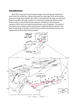
  • 1. Introduction: About 70 km south of the main Himalayan Ranges, the Salt Range was raised due to Main Frontal Thrust (MFT) as a 180-km-long and 85-km-wide ridge of hills at the southern edge of the Potwar Basin Pakistan. MFT, which is associated with salt range, also called Salt Range Thrust (SRT). Salt range is widest in its central part, between the Khewra and the Warchha where it also contains the best exposures of Palaeozoic and Precambrian sequences. All the strata are excellently exposed due to lack of vegetation. The quality of the exposure also provides excellent opportunities to appreciate tectonic features in the field. The Salt Range is, therefore, of international scientific and educational value, and is highly worthy of conservation and preservation. Figure 1-Fig. 1 Location map of the Salt Range in northern Pakistan
  • 2. The name Salt Range was first used by Elphinston in 1808. He visited this territory (1808– 1815) and noticed the extraction of salt from the Salt Range. Hence, historically, the Salt Range derives its name after the occurrence of gigantic deposits of rock salt embedded in the Precambrian bright red marls that are stratigraphically known as the Salt Range Formation (formerly Punjab Saline Series). Apart from the easily available roadside geology, here are some prominent gorges cutting the Salt Range. Among these gorges, we have visited Khewra, Chichali, Zaluch, and Nammal gorge, which provide the fantastic locations to study the sediment Figure 2-Generalized exposed stratigraphic units with major breaks in deposition in the Salt Range, Pakistan
  • 3. The Salt Range contains wealth of geological features, for which it has been rightly called as the “Field Museum of Geology.” Because it has all the sedimentary sequence right from Precambrian upto Eocene. In fact, it represents an open book of geology, where the richly fossiliferous stratified rocks such as the Permian carbonate succession contains brachiopod fauna with conodont biostratigraphy and foraminifera biostratigraphy. We also have collected different Traces and fossils of Trilobites, Bracheopods, Cephalopods, Forms, etc from the field. Salt range is divided into three parts namely eastern, central and western. At eastern side older and at western side mostly younger rocks have been exposed. In our field visit, we have studied stratigraphy of eastern, western (Salt range) and part of Trans-Indus ranges (Surghar range). ➢ EASTERN SALT RANGE (from Jogi Tilla to Nilawahan) ➢ WESTERN SALT RANGE (From Nilawahan to Warchha Mandi) ➢ CENTRAL SALT RANGE (From Warchha Mandi to Mari Indus) Economically salt range is very important for their 2nd largest salt mine in the world. large deposits of high grade Gypsum and Anhydrites, an important calcium minerals, are found Figure 3-a Schematic illustration of the three subdivisions of the Salt Range (modified after Gee and Gee 1989). b Generalized map showing major structural trends in different parts of the Salt Range
  • 4. here in salt range. Beside gypsum, anhydrides and medium grade coal, pink salt of salt range is also very famous all over the world. Pakistan export pink salt of salt range to different countries of the world. Regional tectonics of the Salt Range About 50 millions years ago Indian plate collide with Eurasian plate formed the gaint Himalayas. Due compressive stresses (collision) many thrust faults were produced namely, Main Karakurrum Thrust, Main Mentle Thrust, Main Boundry Thrust and Main Frontal Thrust. Main Frontal thrust that is associated with salt range is called Salt Range Thrust. Due to SRT Salt Range were uplifted. The Salt Range is truncated along the southern margin by Salt Range Frontal Thrust (SRFT), which is bounded between Jehlum and Indus River. It has pushed the older successions of the Salt Range upon the less deformed tertiary sequences of the south lying in the Punjab Plain. The thrust zone is largely covered by Recent conglomerates and Jehlum River alluvium. However, near the Kalabagh area, the thrust is exposed and shows the Palaeozoic rocks overlying the Neogene or Quaternary deposits of the Punjab Plain. At eastern side of the salt range more older (Precambrian) rocks are exposed as compared to western (younger) salt range which shows the strength of stresses that have been applied on this area. We can also trace back the collision behavior of indo- Figure 4-Generalized regional tectonic map of the Salt Range, Pakistan (modified after Kazmi and Rana 1982)
  • 5. eurasion plates collision from the folding and faults that are present in Salt Range. The Salt Range is thus the surface expression of the leading edge of the decollement thrust. Jehlum fault (left handed strike slip fault) marks eastern boundary of the Salt Range, and at western side, Kalabagh fault (Right handed strike slip fault) marks the western limit of Salt Range. The Salt Range is structurally very complex and consists of three basic structural styles: (1) compressional deformation (thrusting and folding), (2) transform deformation (strike faults), and (3) extensional deformation (normal faults). Location of Salt Range Salt Range is located in Indian plate at upper Indus basin of Pakistan, with having east west trending. Salt range is a mountain range of punjab province. Salt Range lies between the valley of Indus and Jehulum river in Punjab province of Pakistan. The range has a length of 180 km and it is highest peak is Sakesar which is approximately 1,600 m. Location of Salt Range can be defined by two ways. 1. On the basis of faults 2. On the basis of geographic view North Kala Chitta Range Potwar Basin Soan Basin Murree Thrust Salt Range Thrust Salt Range ) (central part Sargodha High Punjab Plain Karampur Well South 200 km 80 km 120 km Tertiary Rocks Mesozoic and Palaeozoic Rocks Basement Rocks Salt Range Formation Figure 5-Generalized cross section across the Potwar Basin and the Salt Range, showing Salt Range decollement (modified after Gee 1983). No vertical scale is intended
  • 6. On the basis of faults NORTH: Salt Range is bounded by Main Boundary Thrust fault (MBT) from north side. SOUTH: South limit of the Salt Range is Salt Range Thrust (SRT). EAST: Eastern boundary of the Salt Range is Jehlum Fault (strike slip fault). WEST: At western side of Salt Range Kalabagh Fault (strike slip fault) is present. Figure 6-Figure 6 location of salt Range on the basis of faults. Geographical location of salt range NORTH: Salt Range lies at south of the Potwar plateau means at north of Salt Range Potwar plateau lies. SOUTH: Punjab plane is present at south of the Salt Range. EAST:Jehlum river flowing at east of Salt Range.
  • 7. WEST: Mari Indus or Indus River flowing at west of Salt Range. Figure 7-location of salt range interm of geographic view