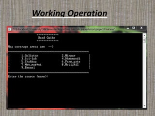
ROAD GUIDE
This is one kind of map system. It will help the
users to find the shortest path to reach their goal.
Introduction
Motivation
Time is valuable. No one wants to waste his or
her time when he or she is moving from one place
to another. So they look for the shortest path that
will take them to their goal. But at present there
is no system that can directly help anyone to find
the shortest path. Hence, a system is required
that can perform as a shortest path finder.
Moreover, the system should be user friendly,
flexible and fast.
ABOUT
The purpose of developing this software project is
to help the users to find the shortest path. This
software is capable of showing the shortest path
distance and direction that is very helpful for the
users. On the basis of certain formulas it will
generate shortest path distance and direction as
output. All the data such as place name, distance
be stored in database as a track record.
Reliability issues
Geodata is expensive
Bandwidth issues
Privacy issues
Features and Benefits
1)Shows the shortest path directly.
2)Takes less time.
3)Easy to operate.
4)Can be used in offline.
5)Saving Money .
User friendly, flexible, fast.
Limitations
1)Unable to detect user’s location
automatically.
2)User has to know where he or she is.
3) Unable to show image of road map.
Tools
1)Code blocks.
2)C++.
3) Dijkstra’s Algorithm
Dijkstra’s Introduction
Dijkstra's algorithm - is a solution to the
single-source shortest path problem in
graph theory.
Works on both directed and undirected
graphs. However, all edges must have
nonnegative wights.
This algorithm finds the path with lowest cost
between that vertex and every other vertex.
According to this algorithm to solve a given
problem we need to solve different part of
problems.
How It Works
Basic Example
Real Life Example
Working Operation
Working Operation
Working Operation
Working Operation
Road Guide

Road Guide