Download to read offline
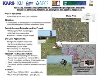
This project used aerial and satellite imagery to assess rangeland condition and monitor trends in Kansas. Researchers aimed to characterize rangeland using spectral measurements and assess how grazing practices impact biophysical and spectral responses. Findings could help ranchers make decisions, map land use at multiple scales, and identify areas needing remediation, with the goal of determining if remote sensing can effectively evaluate rangeland condition and change over time.


![ANIMAL_CELL_,_TISSUE_AND_ORGAN_CULTURE[1].pptx](https://cdn.slidesharecdn.com/ss_thumbnails/animalcelltissueandorganculture1-260204172026-4462b440-thumbnail.jpg?width=640&height=640&fit=bounds)


