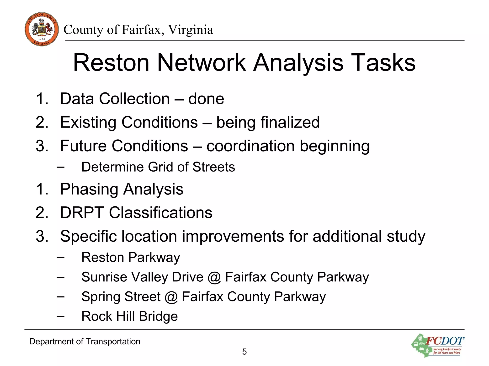
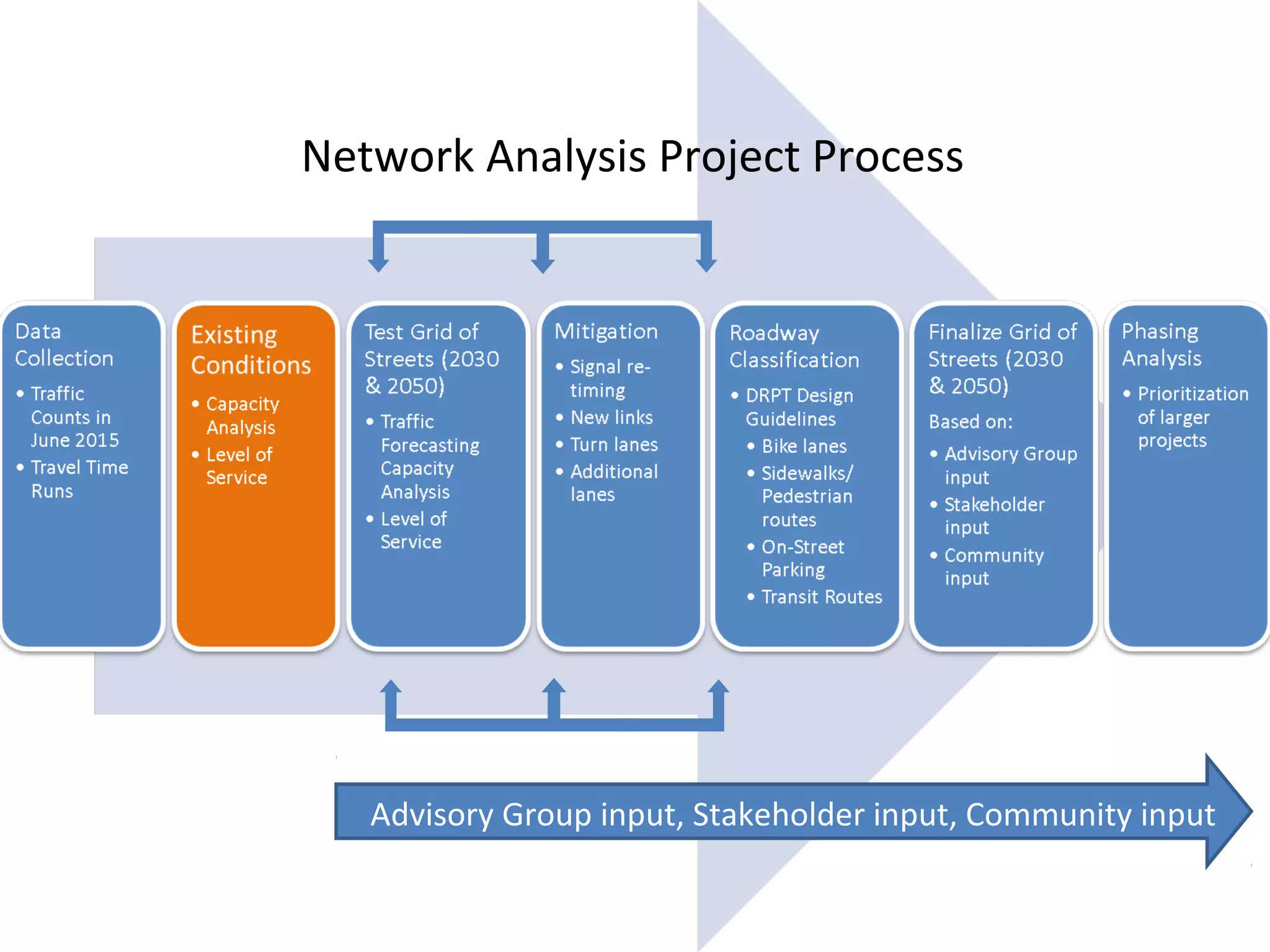
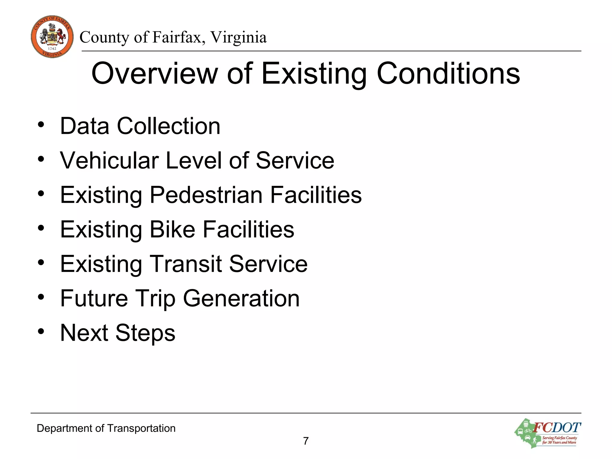
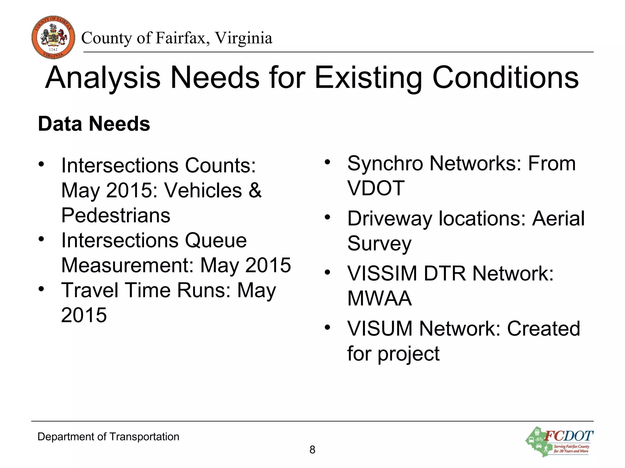
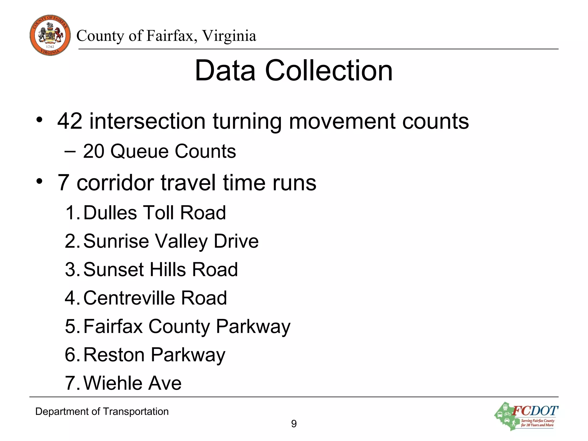
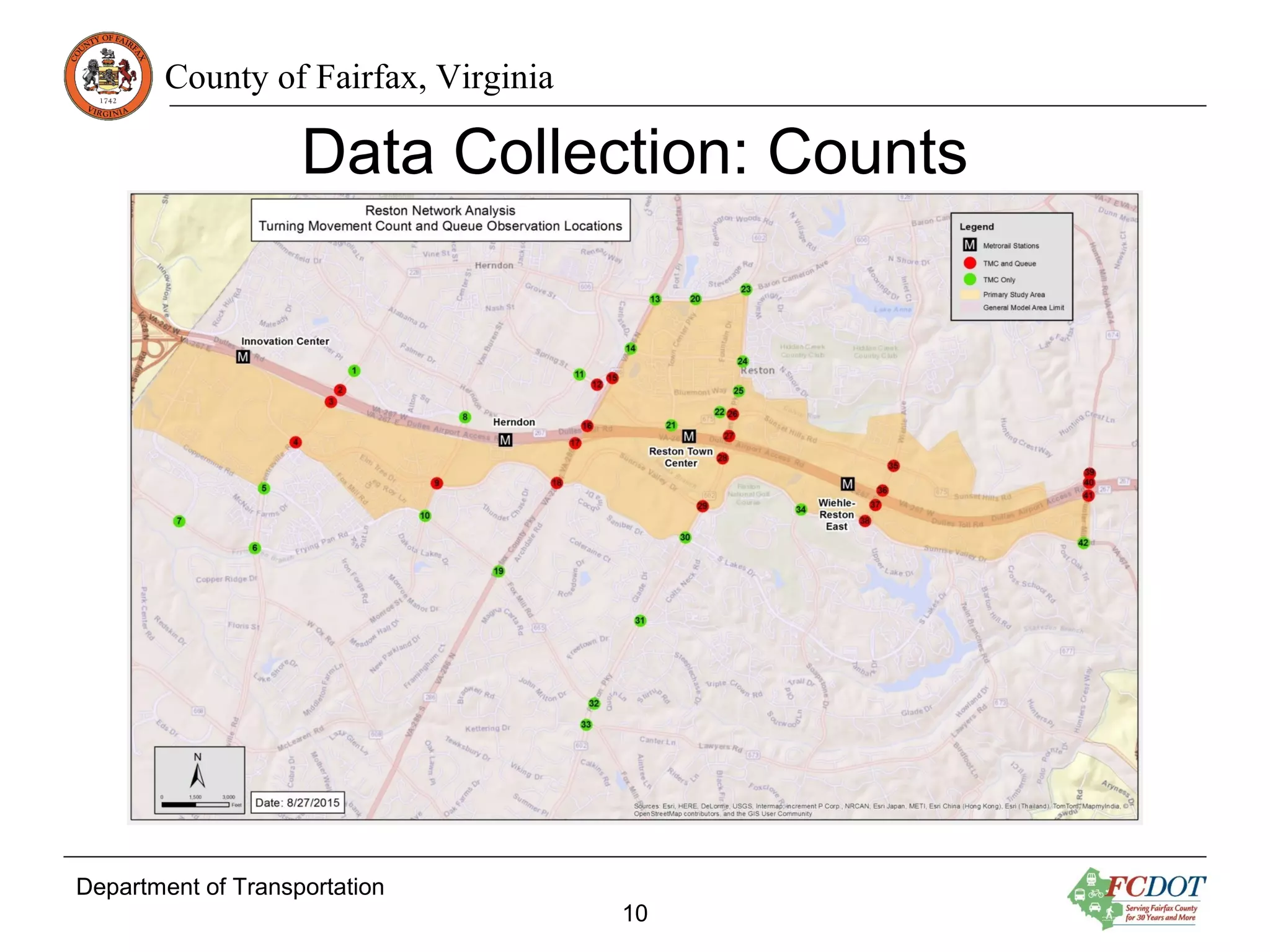
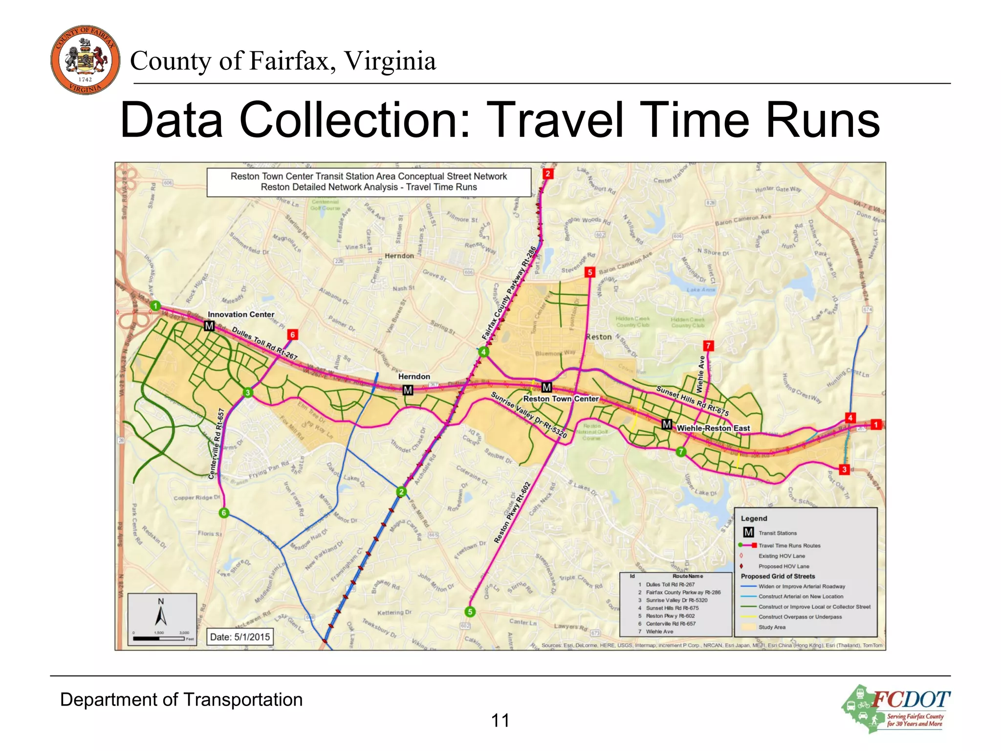
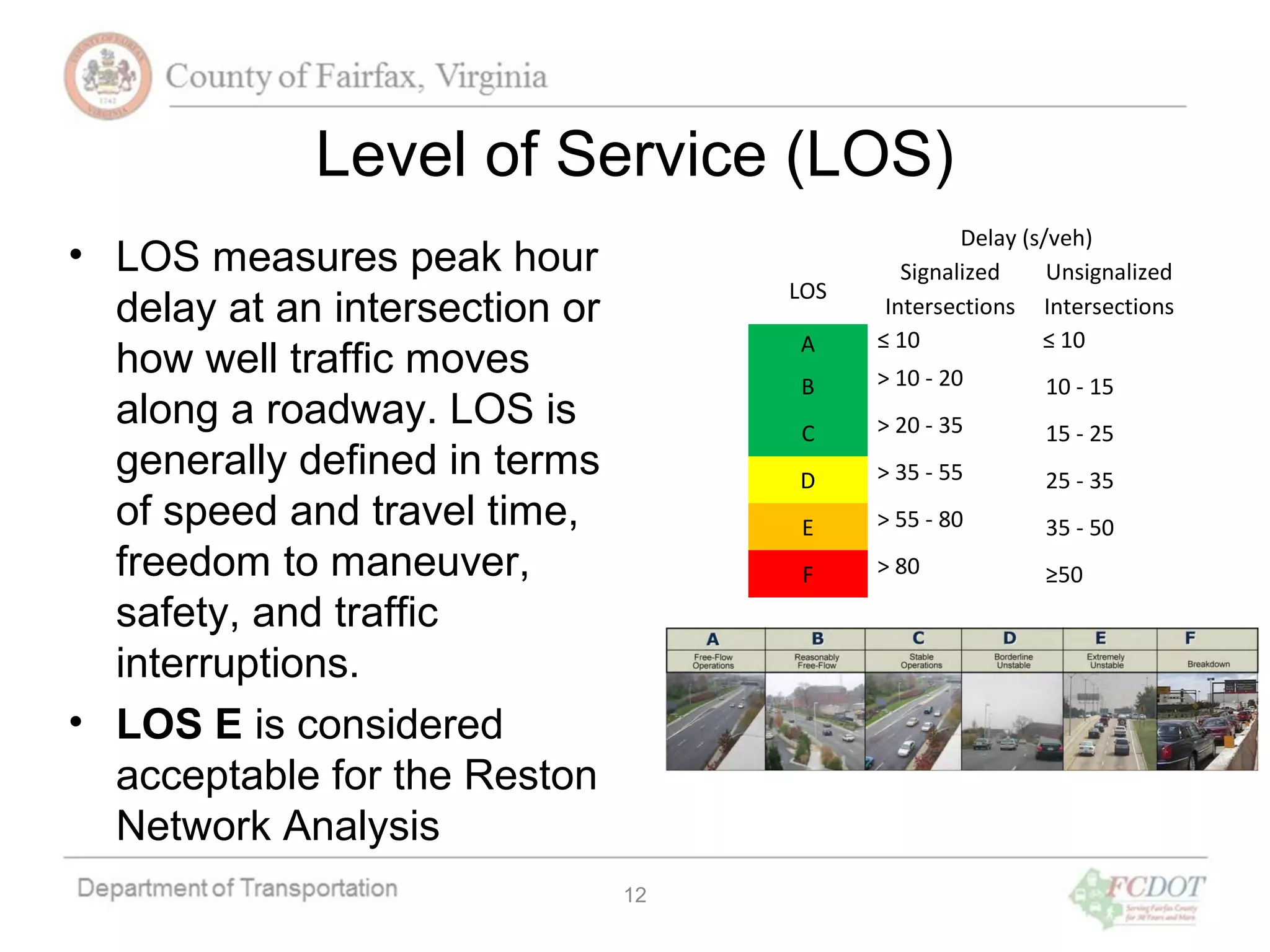
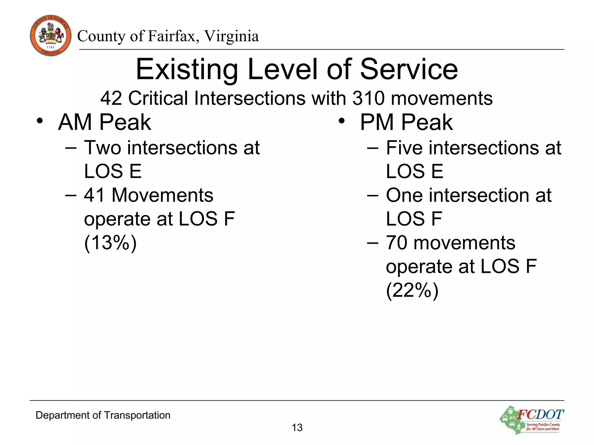
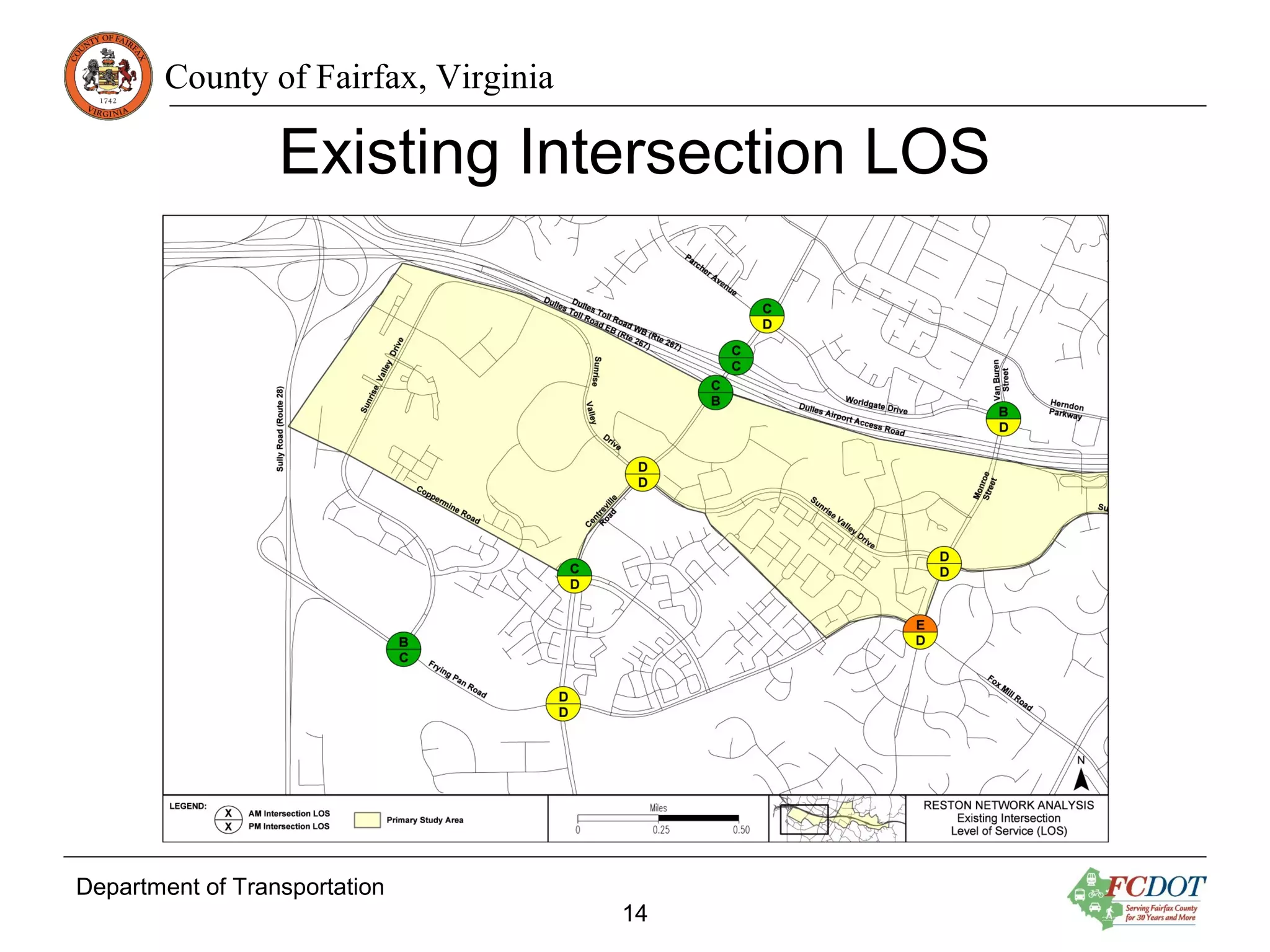
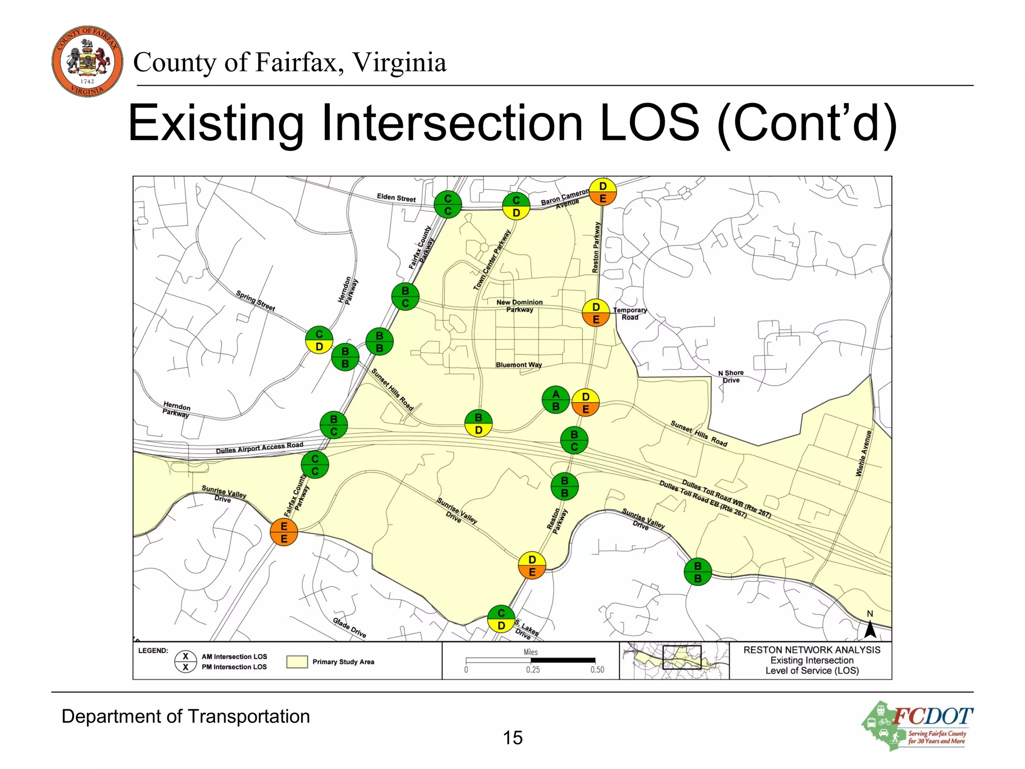
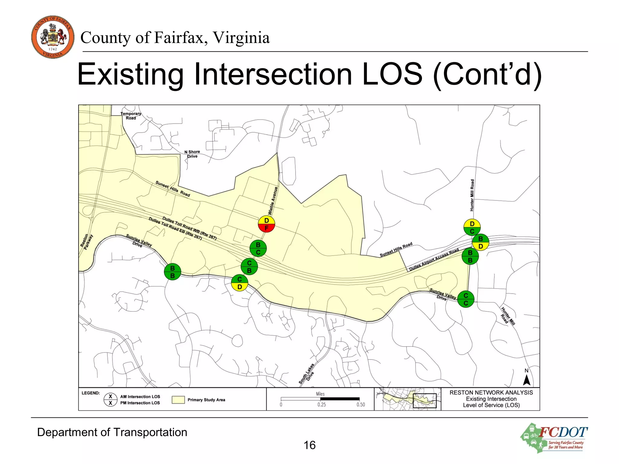
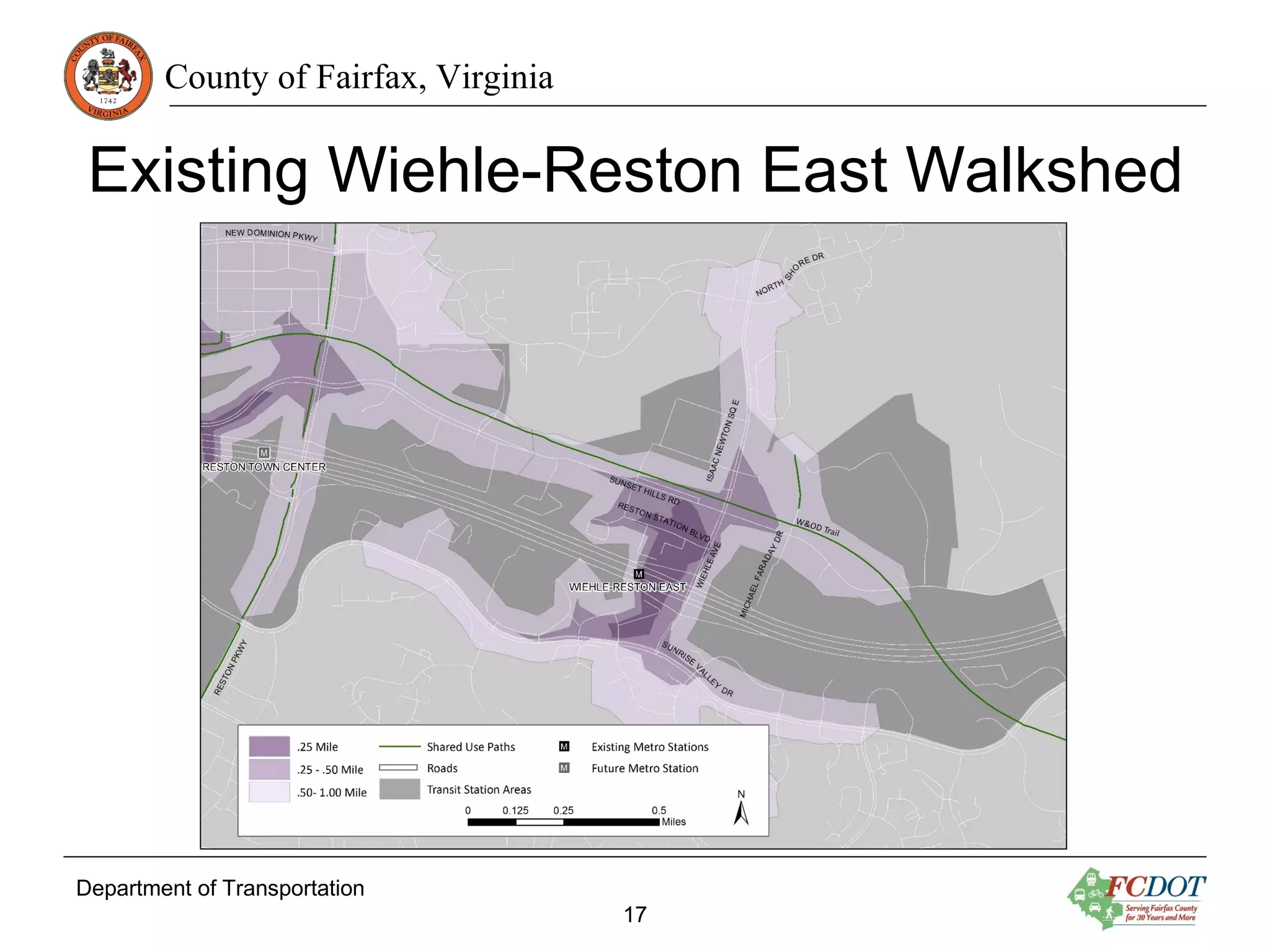
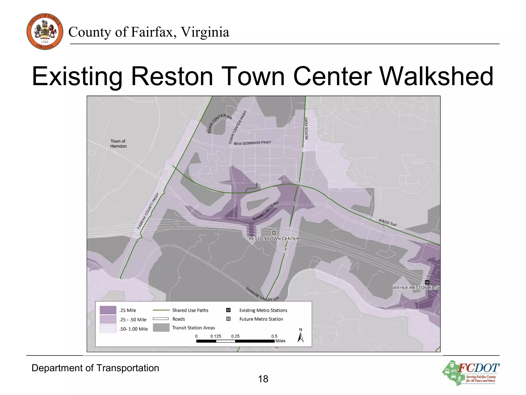
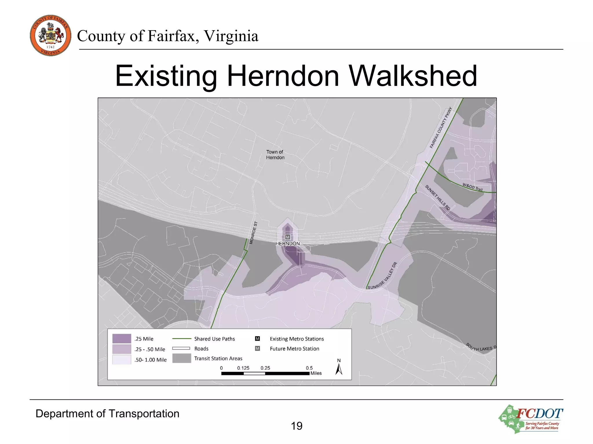
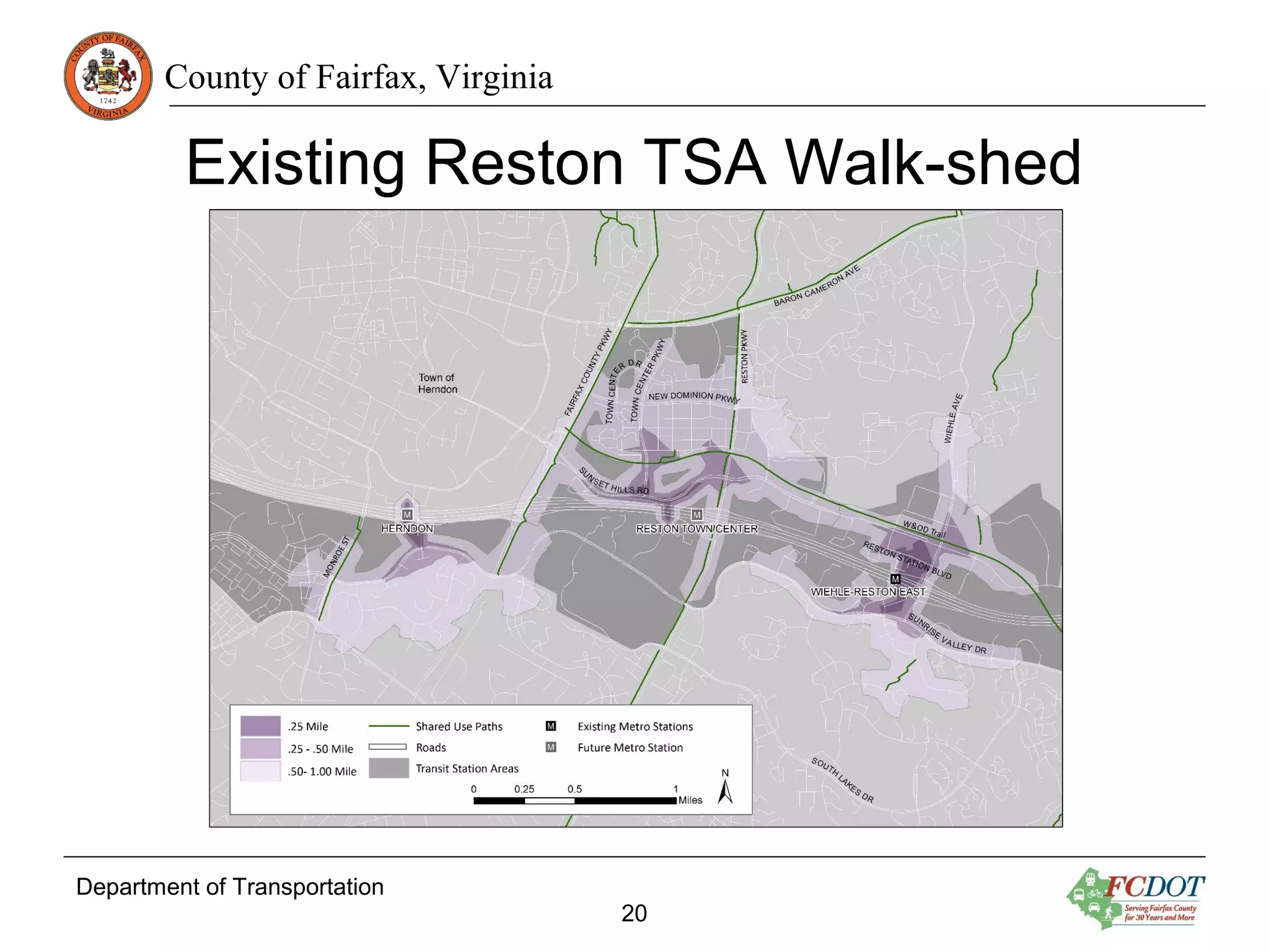
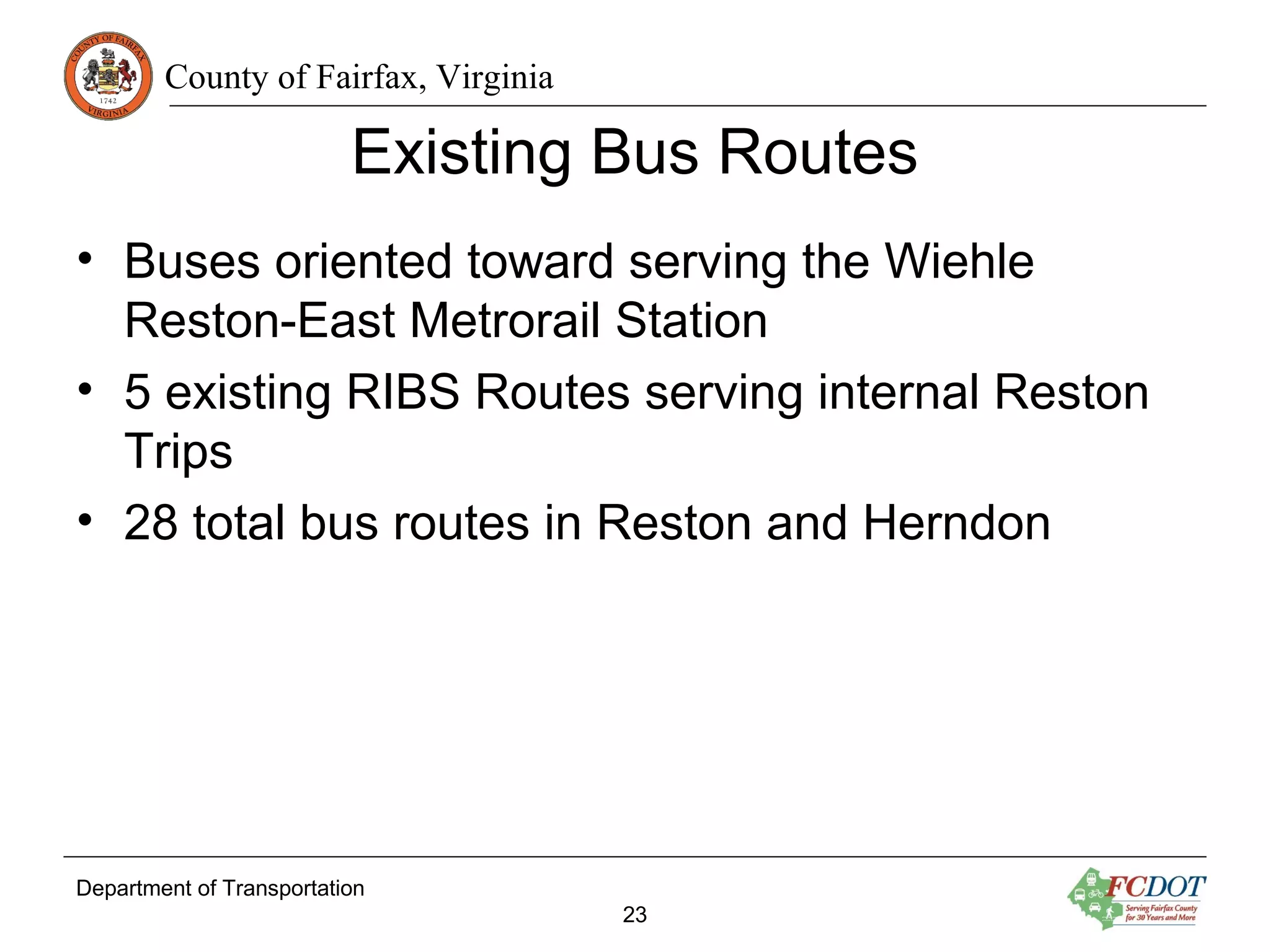
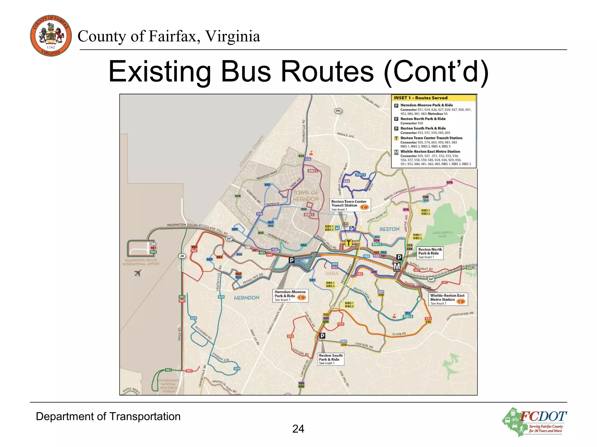
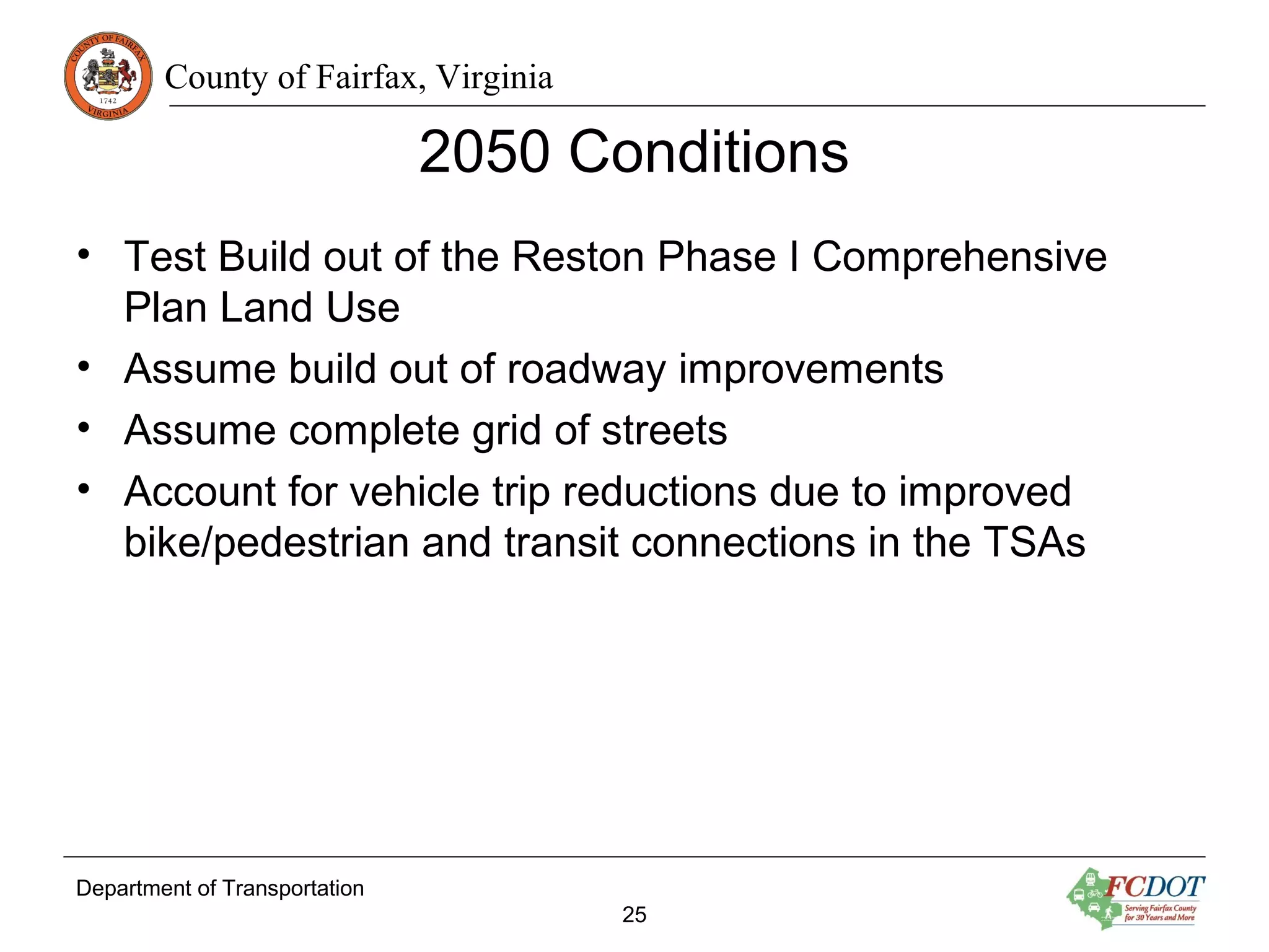
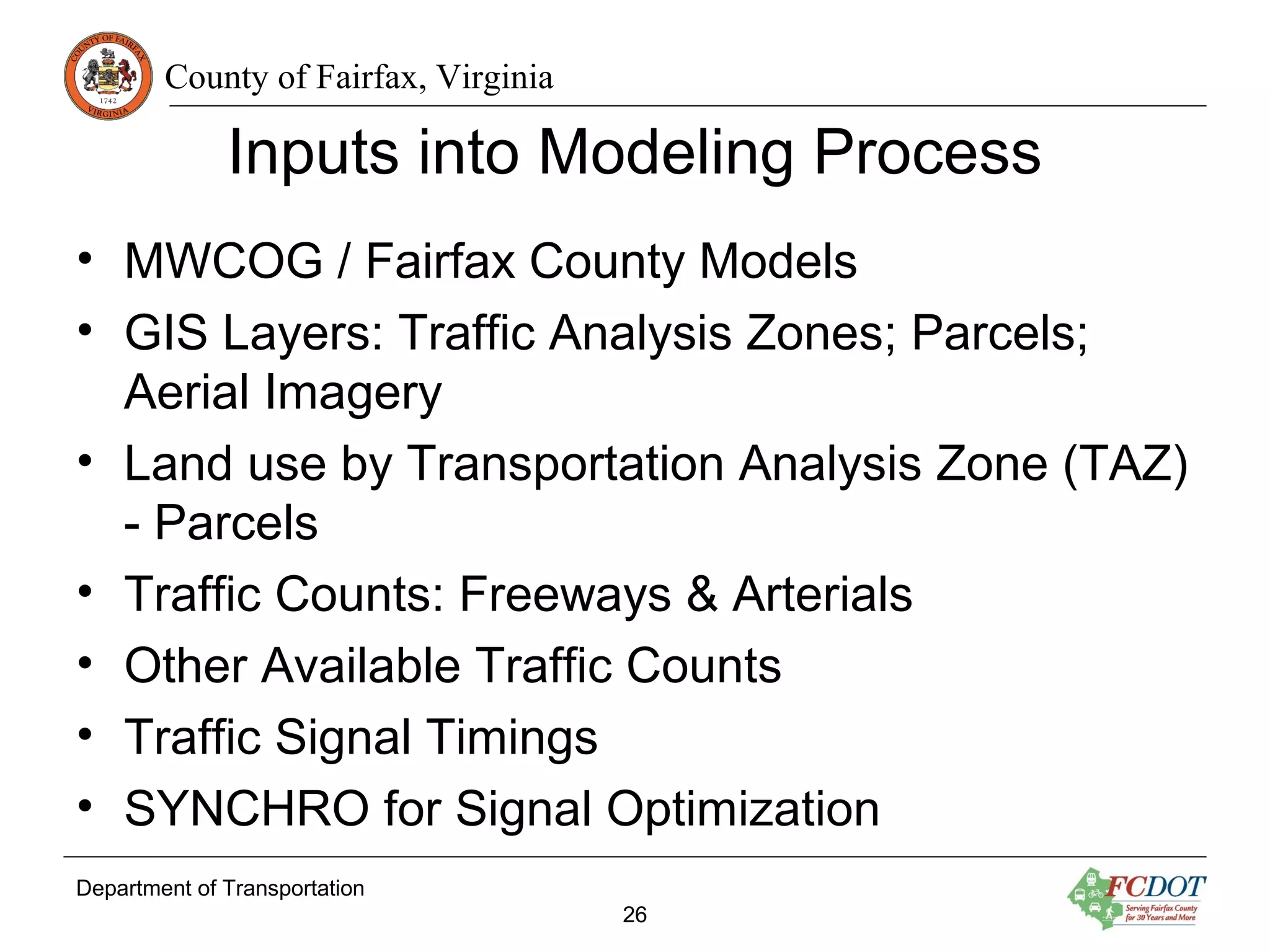
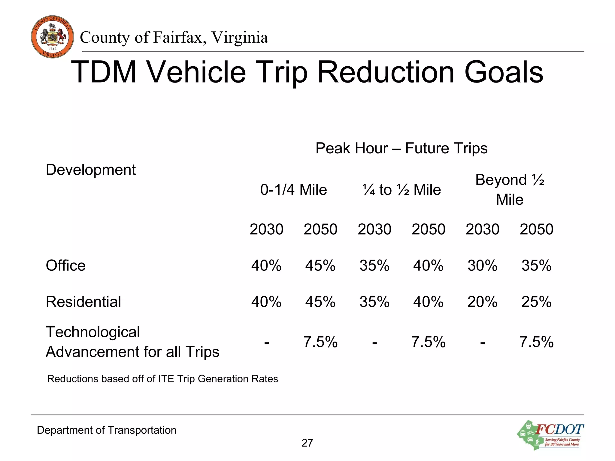
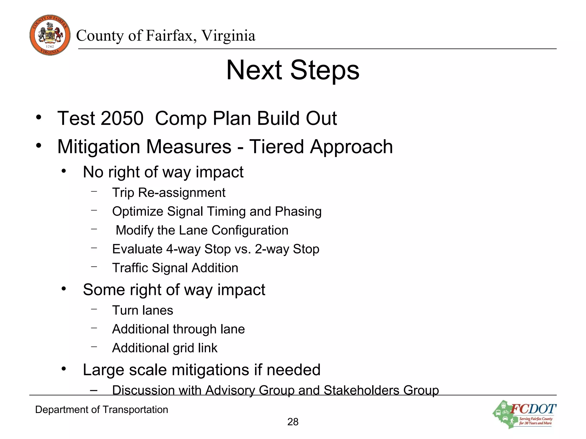
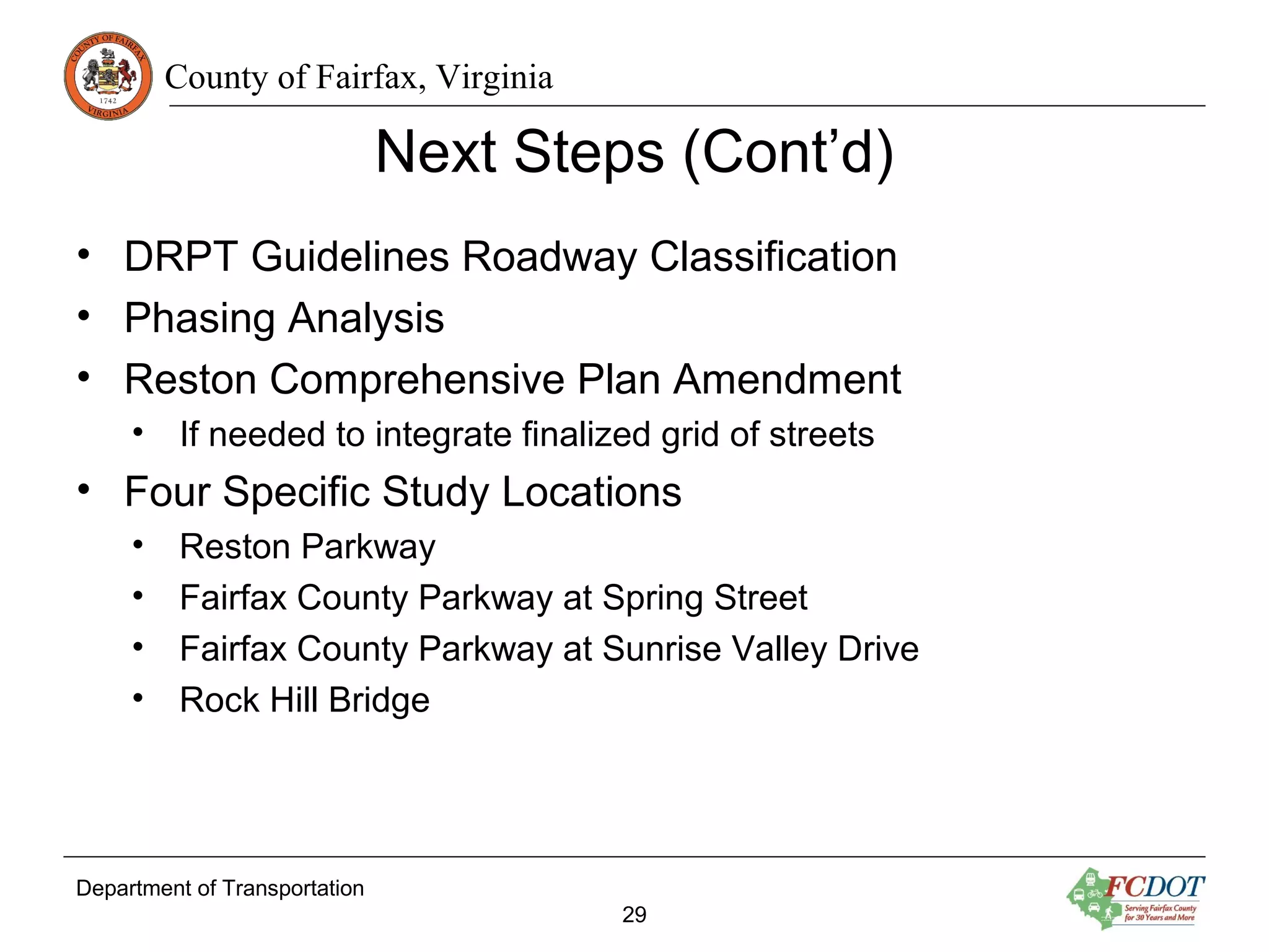
County of Fairfax, Virginia
Department of Transportation
Reston Network Analysis
Existing Conditions
November 9, 2015
Kristin Calkins
Fairfax County Department of Transportation
County of Fairfax, Virginia
Reston Transportation Recommendations
Improvements from Reston Phase I Plan Amendment
Department of Transportation
2
• An Enhanced Street Network to increase connectivity
• Town Center Parkway Underpass
• Soapstone Drive Overpass
• South Lakes Drive Overpass
• Grade Separate Fairfax County Parkway/Sunrise Valley
Drive
County of Fairfax, Virginia
Enhanced Street Network
Department of Transportation
3
• Maintains a balance between land use and transportation
• Provide alternate routes through the TSAs for all modes
• Ensures pedestrian mobility throughout the Transit
Station Areas (TSAs)
• Provides connectivity for bikes
• Support bus service to Metrorail
• Strengthened by a strong Transportation Demand
Management (TDM) program in the TSAs
County of Fairfax, Virginia
Purpose of Study
• Conduct a detailed analysis of the grid of streets to
determine:
– Number of lanes between and at intersections
– How to best serve pedestrians, bikes and transit
– Right-of-way needs
• Assign urban street types and modal emphasis based on
Department of Rail and Public Transportation Multimodal
System Design Guidelines
• Conduct a phasing analysis of when larger projects are
needed
Department of Transportation
4
County of Fairfax, Virginia
Reston Network Analysis Tasks
1. Data Collection – done
2. Existing Conditions – being finalized
3. Future Conditions – coordination beginning
– Determine Grid of Streets
1. Phasing Analysis
2. DRPT Classifications
3. Specific location improvements for additional study
– Reston Parkway
– Sunrise Valley Drive @ Fairfax County Parkway
– Spring Street @ Fairfax County Parkway
– Rock Hill Bridge
Department of Transportation
5
Network Analysis Project Process
Advisory Group input, Stakeholder input, Community input
County of Fairfax, Virginia
Overview of Existing Conditions
• Data Collection
• Vehicular Level of Service
• Existing Pedestrian Facilities
• Existing Bike Facilities
• Existing Transit Service
• Future Trip Generation
• Next Steps
Department of Transportation
7
County of Fairfax, Virginia
Analysis Needs for Existing Conditions
Data Needs
• Intersections Counts:
May 2015: Vehicles &
Pedestrians
• Intersections Queue
Measurement: May 2015
• Travel Time Runs: May
2015
• Synchro Networks: From
VDOT
• Driveway locations: Aerial
Survey
• VISSIM DTR Network:
MWAA
• VISUM Network: Created
for project
Department of Transportation
8
County of Fairfax, Virginia
Data Collection
• 42 intersection turning movement counts
– 20 Queue Counts
• 7 corridor travel time runs
1.Dulles Toll Road
2.Sunrise Valley Drive
3.Sunset Hills Road
4.Centreville Road
5.Fairfax County Parkway
6.Reston Parkway
7.Wiehle Ave
Department of Transportation
9
County of Fairfax, Virginia
Department of Transportation
10
Data Collection: Counts
County of Fairfax, Virginia
Department of Transportation
11
Data Collection: Travel Time Runs
12
Level of Service (LOS)
Delay (s/veh)
LOS
Signalized
Intersections
Unsignalized
Intersections
A ≤ 10 ≤ 10
B > 10 - 20 10 - 15
C > 20 - 35 15 - 25
D > 35 - 55 25 - 35
E > 55 - 80 35 - 50
F > 80 ≥50
• LOS measures peak hour
delay at an intersection or
how well traffic moves
along a roadway. LOS is
generally defined in terms
of speed and travel time,
freedom to maneuver,
safety, and traffic
interruptions.
• LOS E is considered
acceptable for the Reston
Network Analysis
County of Fairfax, Virginia
Existing Level of Service
42 Critical Intersections with 310 movements
• AM Peak
– Two intersections at
LOS E
– 41 Movements
operate at LOS F
(13%)
Department of Transportation
13
• PM Peak
– Five intersections at
LOS E
– One intersection at
LOS F
– 70 movements
operate at LOS F
(22%)
County of Fairfax, Virginia
Department of Transportation
14
Existing Intersection LOS
County of Fairfax, Virginia
Department of Transportation
15
Existing Intersection LOS (Cont’d)
County of Fairfax, Virginia
Department of Transportation
16
Existing Intersection LOS (Cont’d)
County of Fairfax, Virginia
Existing Wiehle-Reston East Walkshed
Department of Transportation
17
County of Fairfax, Virginia
Existing Reston Town Center Walkshed
Department of Transportation
18
County of Fairfax, Virginia
Existing Herndon Walkshed
Department of Transportation
19
County of Fairfax, Virginia
Existing Reston TSA Walk-shed
Department of Transportation
20
County of Fairfax, Virginia
Existing Bike Facilities
Department of Transportation
21
County of Fairfax, Virginia
Planned Bike Facilities
Department of Transportation
22
County of Fairfax, Virginia
Existing Bus Routes
• Buses oriented toward serving the Wiehle
Reston-East Metrorail Station
• 5 existing RIBS Routes serving internal Reston
Trips
• 28 total bus routes in Reston and Herndon
Department of Transportation
23
County of Fairfax, Virginia
Department of Transportation
24
Existing Bus Routes (Cont’d)
County of Fairfax, Virginia
Department of Transportation
25
2050 Conditions
• Test Build out of the Reston Phase I Comprehensive
Plan Land Use
• Assume build out of roadway improvements
• Assume complete grid of streets
• Account for vehicle trip reductions due to improved
bike/pedestrian and transit connections in the TSAs
County of Fairfax, Virginia
Inputs into Modeling Process
• MWCOG / Fairfax County Models
• GIS Layers: Traffic Analysis Zones; Parcels;
Aerial Imagery
• Land use by Transportation Analysis Zone (TAZ)
- Parcels
• Traffic Counts: Freeways & Arterials
• Other Available Traffic Counts
• Traffic Signal Timings
• SYNCHRO for Signal Optimization
Department of Transportation
26
County of Fairfax, Virginia
Department of Transportation
27
Development
Peak Hour – Future Trips
0-1/4 Mile ¼ to ½ Mile
Beyond ½
Mile
2030 2050 2030 2050 2030 2050
Office 40% 45% 35% 40% 30% 35%
Residential 40% 45% 35% 40% 20% 25%
Technological
Advancement for all Trips
- 7.5% - 7.5% - 7.5%
TDM Vehicle Trip Reduction Goals
Reductions based off of ITE Trip Generation Rates
County of Fairfax, Virginia
Department of Transportation
28
Next Steps
• Test 2050 Comp Plan Build Out
• Mitigation Measures - Tiered Approach
• No right of way impact
– Trip Re-assignment
– Optimize Signal Timing and Phasing
– Modify the Lane Configuration
– Evaluate 4-way Stop vs. 2-way Stop
– Traffic Signal Addition
• Some right of way impact
– Turn lanes
– Additional through lane
– Additional grid link
• Large scale mitigations if needed
– Discussion with Advisory Group and Stakeholders Group
County of Fairfax, Virginia
Department of Transportation
29
Next Steps (Cont’d)
• DRPT Guidelines Roadway Classification
• Phasing Analysis
• Reston Comprehensive Plan Amendment
• If needed to integrate finalized grid of streets
• Four Specific Study Locations
• Reston Parkway
• Fairfax County Parkway at Spring Street
• Fairfax County Parkway at Sunrise Valley Drive
• Rock Hill Bridge
County of Fairfax, Virginia
Questions & Comments
Department of Transportation
30
For questions and comments about the study please
contact:
Kristin Calkins: Kristin.Calkins@fairfaxcounty.gov
(703) 877-5710

Reston Network Analysis: Existing Conditions

  • 1.
    County of Fairfax,Virginia Department of Transportation Reston Network Analysis Existing Conditions November 9, 2015 Kristin Calkins Fairfax County Department of Transportation
  • 2.
    County of Fairfax,Virginia Reston Transportation Recommendations Improvements from Reston Phase I Plan Amendment Department of Transportation 2 • An Enhanced Street Network to increase connectivity • Town Center Parkway Underpass • Soapstone Drive Overpass • South Lakes Drive Overpass • Grade Separate Fairfax County Parkway/Sunrise Valley Drive
  • 3.
    County of Fairfax,Virginia Enhanced Street Network Department of Transportation 3 • Maintains a balance between land use and transportation • Provide alternate routes through the TSAs for all modes • Ensures pedestrian mobility throughout the Transit Station Areas (TSAs) • Provides connectivity for bikes • Support bus service to Metrorail • Strengthened by a strong Transportation Demand Management (TDM) program in the TSAs
  • 4.
    County of Fairfax,Virginia Purpose of Study • Conduct a detailed analysis of the grid of streets to determine: – Number of lanes between and at intersections – How to best serve pedestrians, bikes and transit – Right-of-way needs • Assign urban street types and modal emphasis based on Department of Rail and Public Transportation Multimodal System Design Guidelines • Conduct a phasing analysis of when larger projects are needed Department of Transportation 4
  • 5.
    County of Fairfax,Virginia Reston Network Analysis Tasks 1. Data Collection – done 2. Existing Conditions – being finalized 3. Future Conditions – coordination beginning – Determine Grid of Streets 1. Phasing Analysis 2. DRPT Classifications 3. Specific location improvements for additional study – Reston Parkway – Sunrise Valley Drive @ Fairfax County Parkway – Spring Street @ Fairfax County Parkway – Rock Hill Bridge Department of Transportation 5
  • 6.
    Network Analysis ProjectProcess Advisory Group input, Stakeholder input, Community input
  • 7.
    County of Fairfax,Virginia Overview of Existing Conditions • Data Collection • Vehicular Level of Service • Existing Pedestrian Facilities • Existing Bike Facilities • Existing Transit Service • Future Trip Generation • Next Steps Department of Transportation 7
  • 8.
    County of Fairfax,Virginia Analysis Needs for Existing Conditions Data Needs • Intersections Counts: May 2015: Vehicles & Pedestrians • Intersections Queue Measurement: May 2015 • Travel Time Runs: May 2015 • Synchro Networks: From VDOT • Driveway locations: Aerial Survey • VISSIM DTR Network: MWAA • VISUM Network: Created for project Department of Transportation 8
  • 9.
    County of Fairfax,Virginia Data Collection • 42 intersection turning movement counts – 20 Queue Counts • 7 corridor travel time runs 1.Dulles Toll Road 2.Sunrise Valley Drive 3.Sunset Hills Road 4.Centreville Road 5.Fairfax County Parkway 6.Reston Parkway 7.Wiehle Ave Department of Transportation 9
  • 10.
    County of Fairfax,Virginia Department of Transportation 10 Data Collection: Counts
  • 11.
    County of Fairfax,Virginia Department of Transportation 11 Data Collection: Travel Time Runs
  • 12.
    12 Level of Service(LOS) Delay (s/veh) LOS Signalized Intersections Unsignalized Intersections A ≤ 10 ≤ 10 B > 10 - 20 10 - 15 C > 20 - 35 15 - 25 D > 35 - 55 25 - 35 E > 55 - 80 35 - 50 F > 80 ≥50 • LOS measures peak hour delay at an intersection or how well traffic moves along a roadway. LOS is generally defined in terms of speed and travel time, freedom to maneuver, safety, and traffic interruptions. • LOS E is considered acceptable for the Reston Network Analysis
  • 13.
    County of Fairfax,Virginia Existing Level of Service 42 Critical Intersections with 310 movements • AM Peak – Two intersections at LOS E – 41 Movements operate at LOS F (13%) Department of Transportation 13 • PM Peak – Five intersections at LOS E – One intersection at LOS F – 70 movements operate at LOS F (22%)
  • 14.
    County of Fairfax,Virginia Department of Transportation 14 Existing Intersection LOS
  • 15.
    County of Fairfax,Virginia Department of Transportation 15 Existing Intersection LOS (Cont’d)
  • 16.
    County of Fairfax,Virginia Department of Transportation 16 Existing Intersection LOS (Cont’d)
  • 17.
    County of Fairfax,Virginia Existing Wiehle-Reston East Walkshed Department of Transportation 17
  • 18.
    County of Fairfax,Virginia Existing Reston Town Center Walkshed Department of Transportation 18
  • 19.
    County of Fairfax,Virginia Existing Herndon Walkshed Department of Transportation 19
  • 20.
    County of Fairfax,Virginia Existing Reston TSA Walk-shed Department of Transportation 20
  • 21.
    County of Fairfax,Virginia Existing Bike Facilities Department of Transportation 21
  • 22.
    County of Fairfax,Virginia Planned Bike Facilities Department of Transportation 22
  • 23.
    County of Fairfax,Virginia Existing Bus Routes • Buses oriented toward serving the Wiehle Reston-East Metrorail Station • 5 existing RIBS Routes serving internal Reston Trips • 28 total bus routes in Reston and Herndon Department of Transportation 23
  • 24.
    County of Fairfax,Virginia Department of Transportation 24 Existing Bus Routes (Cont’d)
  • 25.
    County of Fairfax,Virginia Department of Transportation 25 2050 Conditions • Test Build out of the Reston Phase I Comprehensive Plan Land Use • Assume build out of roadway improvements • Assume complete grid of streets • Account for vehicle trip reductions due to improved bike/pedestrian and transit connections in the TSAs
  • 26.
    County of Fairfax,Virginia Inputs into Modeling Process • MWCOG / Fairfax County Models • GIS Layers: Traffic Analysis Zones; Parcels; Aerial Imagery • Land use by Transportation Analysis Zone (TAZ) - Parcels • Traffic Counts: Freeways & Arterials • Other Available Traffic Counts • Traffic Signal Timings • SYNCHRO for Signal Optimization Department of Transportation 26
  • 27.
    County of Fairfax,Virginia Department of Transportation 27 Development Peak Hour – Future Trips 0-1/4 Mile ¼ to ½ Mile Beyond ½ Mile 2030 2050 2030 2050 2030 2050 Office 40% 45% 35% 40% 30% 35% Residential 40% 45% 35% 40% 20% 25% Technological Advancement for all Trips - 7.5% - 7.5% - 7.5% TDM Vehicle Trip Reduction Goals Reductions based off of ITE Trip Generation Rates
  • 28.
    County of Fairfax,Virginia Department of Transportation 28 Next Steps • Test 2050 Comp Plan Build Out • Mitigation Measures - Tiered Approach • No right of way impact – Trip Re-assignment – Optimize Signal Timing and Phasing – Modify the Lane Configuration – Evaluate 4-way Stop vs. 2-way Stop – Traffic Signal Addition • Some right of way impact – Turn lanes – Additional through lane – Additional grid link • Large scale mitigations if needed – Discussion with Advisory Group and Stakeholders Group
  • 29.
    County of Fairfax,Virginia Department of Transportation 29 Next Steps (Cont’d) • DRPT Guidelines Roadway Classification • Phasing Analysis • Reston Comprehensive Plan Amendment • If needed to integrate finalized grid of streets • Four Specific Study Locations • Reston Parkway • Fairfax County Parkway at Spring Street • Fairfax County Parkway at Sunrise Valley Drive • Rock Hill Bridge
  • 30.
    County of Fairfax,Virginia Questions & Comments Department of Transportation 30 For questions and comments about the study please contact: Kristin Calkins: Kristin.Calkins@fairfaxcounty.gov (703) 877-5710