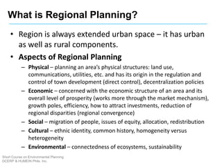
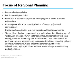
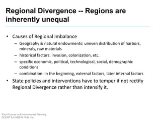
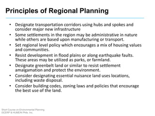
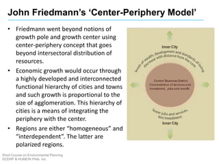
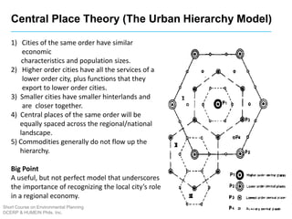
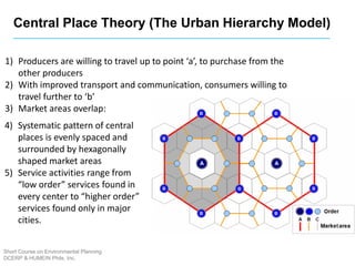
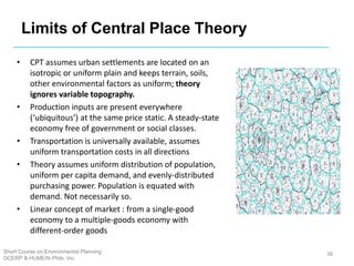
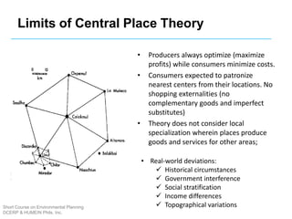
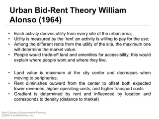
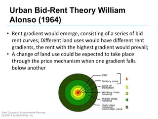
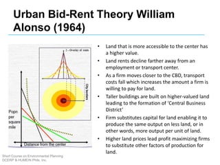
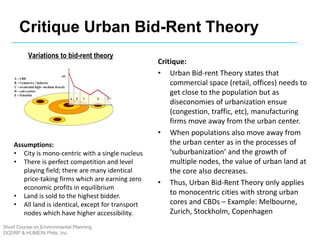
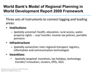
REGIONAL PLANNING
AND DEVELOPMENT
EnP. Angelica N. Francisco
April 3, 2016
CHE Multi Purpose Hall
Short Course on Environmental Planning
DCERP & HUMEIN Phils. Inc.
• Region refers to a city or central place
plus the outlying territories that are
functionally integrated with it.
• Region is based on natural/physical as
well as economic/political relationships
between urban areas and its
surrounding rural territories
• Economic linkages
– Extent of urban influence on nonurban
– areas. e.g. journeys to work
– Extent of urban dependence on non-urban territories
for food, water and labor supplies, etc.
– Production and consumption functions: Industries,
commerce, trade
• Infrastructure linkages
– Major Transport nodes
– Utility trunks – water purification plants, power supply
– Areas performing sink-functions of city, e.g. landfill,
MRF, STP
What is a Region?
Short Course on Environmental Planning
DCERP & HUMEIN Phils. Inc.
• Functional Region – geographical area which displays a certain functional
coherence, an interdependence of parts, defined on the basis of certain
criteria;
– Economic Region – bound by economic linkages, interflows of factors and materials, inputs-and outputs. Economic
Regions are often carved out by Trans-National Corporations and other agents of Globalization by their interlinking
of industrial clusters, districts, zones and ports.
• Region as Space Economy. Traditional Industrial Districts, Clusters, Ecozones,
– Natural Region – a geographic area of interdependent ecosystems and natural communities (this will be discussed in
subsequent sessions under Ecosystem-Based Planning)
• Formal Region – geographical area which is uniform and homogeneous in
terms of related criteria; variability is absent; Used generally for analytic
purposes
– Political-Administrative Regions defined by common political authority, administrative boundaries (national, state,
local) or electoral constituency.
– Urban Region -- region encompassing large cities/towns as well as commuter villages/communities economically
and socially linked to them or dependent upon them. Urban regions are erroneously treated as homogeneous rather
than as physical and socio-cultural mosaic/collage/palimpsest or as a heterogenous “ecosystem”
• Historic Region – area bound together by a common historical past
3
Region in Real Space
Short Course on Environmental Planning
DCERP & HUMEIN Phils. Inc.
• Natural Region – area defined by the
interdependence and connectedness of
natural units and habitats
• Bio-Region – based on interdependence and
natural connectedness of life forms and
species
• Eco-Region – based on interdependence and
natural connectedness of ecosystems and
their communities
4
Types of Region
Short Course on Environmental Planning
DCERP & HUMEIN Phils. Inc.
May 3, 2015
Short Course on Environmental Planning
DCERP, CHE, UPLB
5
1. Early influences from the Garden City Movement (UK) and
New Towns Movement (US)
2. The number of US cities with ‘municipal planning
commissions’ grew from 100 to 500 between 1920 1930.
3. Regional Planning Association of America was founded in
1923-25
 published “Survey” – a manifesto containing the concept of a region
 members - architects, engineers, surveyors, sculptors, artists, sociologists (lawyers
associate members only)
 result - interdisciplinary approach to planning
4. Town and Country Planning Act of 1947 (UK)
 Concerned with the spatial impact of problems and the spatial coordination of many
different policies
 Method of Planning – man assumes control over physical and human matter and
processes it to serve his defined needs
History of Regional Planning Movement
Short Course on Environmental Planning
DCERP & HUMEIN Phils. Inc.
5. Benton MacKaye published The New Exploration: A
Philosophy of Regional Planning, 1928
6. Thomas Adams and Lewis Mumford debated the multi-
volume Regional Plan of New York, 1928-1932
7. Regional Planning on counties, river basins, valleys, dams,
rangeland, ancestral land -- Los Angeles County, 1922;
Appalachian Trail, 1928; Tennessee Valley Authority 933;
Grand Coulee Dam 1935; Colorado River- Hoover Dam 1936;
St Lawrence Seaway, 1959; Delaware River 1961; Miami
(Ohio) Valley 1970.
8. Regional Planning easily dovetailed with Transportation
Planning (Penn-Jersey, 1954; Chicago-Detroit, 1954)
History of Regional Planning Movement
Short Course on Environmental Planning
DCERP & HUMEIN Phils. Inc.
Garden City – Ebenezer Howard
Short Course on Environmental Planning
DCERP & HUMEIN Phils. Inc.
• Garden City most potent planning model in
Western urban planning
• Created by Ebenezer Howard in 1898 to solve
urban and rural problems
• Founder of Garden City Movement
• Emphasizing self-contained communities
surrounded by "greenbelts"
Short Course on Environmental Planning
DCERP & HUMEIN Phils. Inc.
Core Garden City Principles:
• Strong community
• Ordered development
• Environmental quality
These were achieved by:
- Unified ownership of land to prevent individual land
- Speculation and maximize community benefit
- Careful planning to provide generous living and
- Working space while maintaining natural qualities
- Social mix and good community facilities
- Limits to growth of each garden city
- Local participation in decisions about development
Garden City – Ebenezer Howard
Short Course on Environmental Planning
DCERP & HUMEIN Phils. Inc.
• Father of modern town planning / regional
planning
• First to link sociological concepts into town
planning
• “Survey before plan” i.e. diagnosis before
treatment
• The sequence of planning is to be: (a) regional
survey; (b) rural development; (c) town planning;
and (d) city design
• These are to be kept constantly up to –date
Geddisian Triad – Patrick Geddes
Short Course on Environmental Planning
DCERP & HUMEIN Phils. Inc.
• Conurbation – waves of population inflow to large
cities followed by overcrowding and slum formation,
and then the wave of backflow – the whole process
resulting in amorphous sprawl, waste, and
unnecessary obsolescence.
• A conurbation is a region comprising a number of
cities, large towns, and other urban areas that,
through population growth and physical expansion,
have merged to form one continuous urban and
industrially developed area.
Patrick Geddes – Planning Concepts:
Short Course on Environmental Planning
DCERP & HUMEIN Phils. Inc.
• A tool for regional
analysis, index-museum
and the world’s first
sociological laboratory
• It represents the essence
of Geddes’ thought – his
holism, visual thinking,
and commitment to
understanding the city in
the region
Patrick Geddes – Outlook Tower:
• It concerns planning for a sub-national territory with known
scale (size) and extent (scope), normally a contiguous area
whose parts have common or complementary
characteristics and are linked by intensive interaction or
flows. The whole region is set apart from neighbouring
territories by its distinctive economic and social
characteristics, continuities and discontinuities, opportunities
and problems, even though it may not have defined local
authority structures and clear administrative boundaries.
• It is intermediate between national and urban levels and
straddles the gap between national and grassroots levels.
What is Regional Planning?
Short Course on Environmental Planning
DCERP & HUMEIN Phils. Inc.
• Region is always extended urban space – it has urban
as well as rural components.
• Aspects of Regional Planning
– Physical – planning an area’s physical structures: land use,
communications, utilities, etc. and has its origin in the regulation and
control of town development (direct control), decentralization policies
– Economic – concerned with the economic structure of an area and its
overall level of prosperity (works more through the market mechanism),
growth poles, efficiency, how to attract investments, reduction of
regional disparities (regional convergence)
– Social – migration of people, issues of equity, allocation, redistribution
– Cultural – ethnic identity, common history, homogeneity versus
heterogeneity
– Environmental – connectedness of ecosystems, sustainability
What is Regional Planning?
Short Course on Environmental Planning
DCERP & HUMEIN Phils. Inc.
• Decentralization policies
• Distribution of population
• Reduction of economic disparities among regions – versus economic
polarization
• Inter-regional allocation or redistribution of resources (regional
convergence)
• Institutional capacitation (e.g. reorganization of local governments)
• The problem of urban congestion is at a scale where the old categories of
“urban, suburban and rural” no longer suffice. Hence “region” is a cross-
cutting, more encompassing concept that treats cities in relation to its
environs; this new approach also considers principles of ecological balance
and resource renewal. Cities under this scheme would become
subordinate to region; old cities and new towns alike grow as necessary
parts of a region
Focus of Regional Planning
Short Course on Environmental Planning
DCERP & HUMEIN Phils. Inc.
• Causes of Regional Imbalance
– Geography & natural endowments: uneven distribution of harbors,
minerals, raw materials
– historical factors: invasion, colonization, etc.
– specific economic, political, technological, social, demographic
conditions
– combination: in the beginning, external factors, later internal factors
• State policies and interventions have to temper if not rectify
Regional Divergence rather than intensify it.
Regional Divergence -- Regions are
inherently unequal
Short Course on Environmental Planning
DCERP & HUMEIN Phils. Inc.
Principles of Regional Planning
Short Course on Environmental Planning
DCERP & HUMEIN Phils. Inc.
• Designate transportation corridors using hubs and spokes and
consider major new infrastructure
• Some settlements in the region may be administrative in nature
while others are based upon manufacturing or transport.
• Set regional level policy which encourages a mix of housing values
and communities.
• Resist development in flood plains or along earthquake faults.
These areas may be utilized as parks, or farmland.
• Designate greenbelt land or similar to resist settlement
amalgamation and protect the environment.
• Consider designating essential nuisance land uses locations,
including waste disposal.
• Consider building codes, zoning laws and policies that encourage
the best use of the land.
Regional Planning as Networking
Short Course on Environmental Planning
DCERP & HUMEIN Phils. Inc.
The new paradigm of Regional Planning since the 1990s:
1. The real assets of a region are the actors within the region,
their resources and the specific regional culture of
cooperation, communication and competition.
2. The core of spatial planning is no longer the elaboration of
plans and programs. Regional development must promote
the realization of planning goals by supporting the
cooperation between different stakeholders, both from
public administration and the private sector.
3. Planning and acting in networks is especially important at
the regional level.
4. The role of space becomes different and planners need
special knowledge (ex. international marketing)
Clarence Stein’s Six Principles of New Towns
(1920s, USA) – Earliest Regional Planning Efforts
Short Course on Environmental Planning
DCERP & HUMEIN Phils. Inc.
1. Plan simply, but
comprehensively
2. Provide ample sites in the right
places for community use
3. Put factories and other
industrial buildings where they
can be used without wasteful
transportation of people and
goods
4. Cars must be parked and stored
(not on the streets!)
5. Bring private and public land
into relationship
6. Arrange for the occupancy of
houses
The Neighborhood Unit - Clarence Perry (1929)
Short Course on Environmental Planning
DCERP & HUMEIN Phils. Inc.
• The neighbourhood is the
planning unit for a town
• Evolved due to the advent
of industrial revolution
and degradation of the
city environment caused
due to: (a) high
congestion; (b) heavy
traffic movement through
the city; (c) insecurity to
school going children; (d)
distant location of
shopping and recreation
activities
Short Course on Environmental Planning
DCERP & HUMEIN Phils. Inc.
• A satellite town or satellite city is a concept in urban planning that
refers essentially to smaller metropolitan areas on the fringe of
larger metropolis.
Characteristics:
• Satellite cities are small or medium-sized cities near a large
metropolis
• Predate that metropolis’ suburban expansion
• Are at least partially independent from that metropolis
economically and socially
• Are physically separated from the metropolis by rural territory;
satellite cities should have their own independent urbanized area,
or equivalent
• Have their own bedroom communities
• Have a traditional downtown surrounded by traditional inner city
neighborhoods
Satellite Towns
Ribbon Development
Short Course on Environmental Planning
DCERP & HUMEIN Phils. Inc.
• Ribbon development means building
houses along the routes of
communication radiating from a
human settlement
• Following the industrial revolution,
ribbon development became prevalent
along railway lines –predominantly in
the UK, Russia and United States
• Ribbon development can also be
compared with a linear village which is
a village that grew along a
transportation route, not as part of a
city’s expansion
‘Growth Pole’ Theory by Francois Perroux
Short Course on Environmental Planning
DCERP & HUMEIN Phils. Inc.
• “Growth does not appear everywhere and all at once; it
manifests itself in points or ‘poles’ of growth, with variable
intensities; it spreads by different channels with variable
terminal effects for the economy as a whole.”
• Growth Pole –A spatial agglomeration of related industries
which contains a growing number of propulsive firms, which,
through their expansion, induce growth in the surrounding
hinterland
• Propulsive firm/ industry -- dominant economic unit which
when it grows or innovates, induces growth in the other
economic units. It may be a firm, a cluster of firms within the
same sector (i.e., an industry), or a collection of firms which
have shared agreement (industrial estate).
• Characteristics of propulsive firms: large size; fast growth;
strong linkages; innovative
– Direct and indirect dominating influence over all other activities
– Oligopolistic concentration of industry with price leadership and
keen sense of anticipation in the moves of its own sector as well
as related branches
Growth Center by Jacques R. Boudeville
Short Course on Environmental Planning
DCERP & HUMEIN Phils. Inc.
• Transformed ‘Growth Pole’ into a specific place within a region that is
heterogeneous, continuous, and not specialized.
• Growth Center (geographic space) is a propulsive urban center of a region
possessing a complex of expanding industries where the agglomeration of
activities induces growth in its surrounding hinterland. The growth center has
growth rate of population or employment that is greater than that of total region.
• “Regional growth center” refers to “a set of expanding industries located in an
urban area and inducing further development of economic activity throughout its
zone of influence” with complex activities around propulsive center
• Growth Inducement Mechanisms: disturbances or changes are then spread over
the whole region: Polarization, Agglomeration, Spread Effects
• Growth centers are often crafted onto “hierarchy of central places”
– Central place functions = number of functions
– Nodal location = predominant flows
– Location on the development surface = level of development indifferent locations
– Population growth rate
Usefulness of Growth Pole / Growth Center
Short Course on Environmental Planning
DCERP & HUMEIN Phils. Inc.
• Efficient way of generating development –
owing to agglomeration economies
• Less public expenditures if investment areas are
concentrated in specific growth points
• Spread effects out of the growth point will help
solve the problems of depressed regions
• Transportation routes as channels of growth
• Useful to understand regional structures and
designate regional centers, predict changes or
prescribe solutions to certain regional problems
• Inspired the Philippine strategy of
“concentrated decentralization” where
alternative urban centers serve as counter
magnets to the Primate City (NCR) which has
caused “economic polarization”
‘Theory of Cumulative Causation’ (1957)
by Gunnar Myrdal, Nobel Laureate
Short Course on Environmental Planning
DCERP & HUMEIN Phils. Inc.
• Capitalism is characterized by income and welfare inequalities based on
history
• In countries divided into regions, growth will not be the same.
Disequilibrium in economy is due to market forces; Market forces
create regional inequalities and widen those which already exist.
Market forces, if left alone, tend to increase rather than decrease
inequalities between regions
• Regions with expanding economic activity will attract net migration
from other parts of the country, thus favoring the growth regions.
• Circular and cumulative causation
– Change in some variables does not bring the system back to equilibrium = induces
supporting changes farther from the initial state
– A region or country becomes richer, the poor becomes poorer because of
cumulative process where forces work in circular causation to reinforce
development or underdevelopment.
– “The poor becomes poorer and the rich becomes richer.”
‘Theory of Cumulative Causation’ (1957)
by Gunnar Myrdal, Nobel Laureate
Short Course on Environmental Planning
DCERP & HUMEIN Phils. Inc.
• Trade operates with the same fundamental bias in favor of more
progressive regions
• Government policy should be to counteract tendency of
capitalist system to foster regional inequalities. Government
needs to intervene to decrease imbalances wherever the normal
market mechanisms proves inadequate.
• Linkage – input-output relationships among firms or among
industries
• Forward linkage – outputs or sales from one intermediate
firm/industry is maximally utilized by another firm/industry
• Backward linkage – factors of production or intermediary inputs
from one firm/industry is maximally utilized by another
firm/industry
Theory of Cumulative Causation
Short Course on Environmental Planning
DCERP & HUMEIN Phils. Inc.
Gunnar Myrdal’s Theory of Cumulative Causation
Short Course on Environmental Planning
DCERP & HUMEIN Phils. Inc.
John Friedmann’s ‘Center-Periphery Model’
Short Course on Environmental Planning
DCERP & HUMEIN Phils. Inc.
• Friedmann went beyond notions of
growth pole and growth center using
center-periphery concept that goes
beyond intersectoral distribution of
resources.
• Economic growth would occur through
a highly developed and interconnected
functional hierarchy of cities and towns
and such growth is proportional to the
size of agglomeration. This hierarchy of
cities is a means of integrating the
periphery with the center.
• Regions are either “homogeneous” and
“interdependent”. The latter are
polarized regions.
Short Course on Environmental Planning
DCERP & HUMEIN Phils. Inc.
• The periphery of a polarized region can be
divided into four parts: upward transitional,
downward transitional, resource frontier and
special problem.
– Upward transitional regions are areas which are growing
– with high growth potential but are capital constrained.
– Downward transitional regions are old rural (or industrial)
economies in decline and where emigration is most evident.
– Resource frontiers are new settlement zones in which potentials
for growth is large.
– Special problem regions are those needing policy interventions
more than the other cited regions.
• This classification allows distinction of regions
according to needed policy actions and that
the treatment of regional problems are not
taken in isolation but in consideration of the
whole regional system.
John Friedmann’s ‘Center-Periphery Model’
Agropolis by John Friedman
Short Course on Environmental Planning
DCERP & HUMEIN Phils. Inc.
• Connect urban area with its
surrounding rural areas
• Selective Territorial Closure –
trade among yourselves,
basically self reliance, focus on
domestic demand, not exports
• Basic Needs Approach
• “Agropolis” became a model
for “Integrated Area
Development” in regional
planning.
‘Central Place Theory’ by Walter Christaller
• Central Place is a village/town/city that is engaged
in settlement-forming trade and provides a
common location for the local exchange of goods
and services
• ‘Hinterland’ is the surrounding area or Market Area
being served by a central place; it is a large
tributary
• There is clustering of human population around
Central Places through time until a Hierarchy of
Settlements appears that corresponds to the
market’s need for low-level to high-level services.
• The larger the settlements, the fewer their number.
The larger a settlement, the farther away a similar
size settlement is.
• The range of market increases as the population
increases
• The larger the settlement, the higher the order of
its services. Deviations to this rule are:
 Tourist resorts that have a small population but large number of
functions.
 Dormitory towns that have a large population but a small
number of functions
Short Course on Environmental Planning
DCERP & HUMEIN Phils. Inc.
Central Place Theory (The Urban Hierarchy Model)
1) Cities of the same order have similar
economic
characteristics and population sizes.
2) Higher order cities have all the services of a
lower order city, plus functions that they
export to lower order cities.
3) Smaller cities have smaller hinterlands and
are closer together.
4) Central places of the same order will be
equally spaced across the regional/national
landscape.
5) Commodities generally do not flow up the
hierarchy.
Big Point
A useful, but not perfect model that underscores
the importance of recognizing the local city’s role
in a regional economy.
Short Course on Environmental Planning
DCERP & HUMEIN Phils. Inc.
1) Producers are willing to travel up to point ‘a’, to purchase from the
other producers
2) With improved transport and communication, consumers willing to
travel further to ‘b’
3) Market areas overlap:
4) Systematic pattern of central
places is evenly spaced and
surrounded by hexagonally
shaped market areas
5) Service activities range from
“low order” services found in
every center to “higher order”
services found only in major
cities.
Short Course on Environmental Planning
DCERP & HUMEIN Phils. Inc.
Central Place Theory (The Urban Hierarchy Model)
Scalogram as a Measure of Centrality
A Scalogram Matrix is used to arrange the different types of facilities and services and
rank them by their level of ubiquity and functional complexity.
The scalogram can also be used as a general reference in making decisions about
locating services and facilities in order to increase potential access for communities
within various levels of the hierarchy.
Usefulness of Central Place Theory
• Theory stresses relevance of market area to the size of a
town’s population
• Theory highlights the importance of situation rather than site
conditions
• Theory introduces urban hierarchy, helps understand the
emergence of an integrated hierarchy of cities of different
functions and sizes.
• Theory served as basis for administering urban regions and for
allocating resources (for investment decisions)
• Provides framework for understanding regional spatial
structure
Short Course on Environmental Planning
DCERP & HUMEIN Phils. Inc.
Limits of Central Place Theory
• CPT assumes urban settlements are located on an
isotropic or uniform plain and keeps terrain, soils,
other environmental factors as uniform; theory
ignores variable topography.
• Production inputs are present everywhere
(‘ubiquitous’) at the same price static. A steady-state
economy free of government or social classes.
• Transportation is universally available, assumes
uniform transportation costs in all directions
• Theory assumes uniform distribution of population,
uniform per capita demand, and evenly-distributed
purchasing power. Population is equated with
demand. Not necessarily so.
• Linear concept of market : from a single-good
economy to a multiple-goods economy with
different-order goods
38
Short Course on Environmental Planning
DCERP & HUMEIN Phils. Inc.
• Producers always optimize (maximize
profits) while consumers minimize costs.
• Consumers expected to patronize
nearest centers from their locations. No
shopping externalities (no
complementary goods and imperfect
substitutes)
• Theory does not consider local
specialization wherein places produce
goods and services for other areas;
• Real-world deviations:
 Historical circumstances
 Government interference
 Social stratification
 Income differences
 Topographical variations
Short Course on Environmental Planning
DCERP & HUMEIN Phils. Inc.
Limits of Central Place Theory
Urban Bid-Rent Theory William
Alonso (1964)
Short Course on Environmental Planning
DCERP & HUMEIN Phils. Inc.
• Each activity derives utility from every site of the urban area;
• Utility is measured by the ‘rent’ an activity is willing to pay for the use;
• Among the different rents from the utility of the site, the maximum one
will determine the market value.
• People would trade-off land and amenities for accessibility; this would
explain where people work and where they live.
• Land value is maximum at the city center and decreases when
moving to peripheries;
• Rent diminishes outward from the center to offset both expected
lower revenues, higher operating costs, and higher transport costs
• Gradient is determined by rent and influenced by location and
corresponds to density (distance to market)
Urban Bid-Rent Theory William
Alonso (1964)
Short Course on Environmental Planning
DCERP & HUMEIN Phils. Inc.
• Rent gradient would emerge, consisting of a series of bid
rent curves; Different land uses would have different rent
gradients, the rent with the highest gradient would prevail;
• A change of land use could be expected to take place
through the price mechanism when one gradient falls
below another
Urban Bid-Rent Theory William
Alonso (1964)
• Land that is more accessible to the center has
a higher value.
• Land rents decline farther away from an
employment or transport center.
• As a firm moves closer to the CBD, transport
costs fall which increases the amount a firm is
willing to pay for land.
• Taller buildings are built on higher-valued land
leading to the formation of ‘Central Business
District’
• Firm substitutes capital for land enabling it to
produce the same output on less land, or in
other words, more output per unit of land.
• Higher land prices lead profit maximizing firms
to substitute other factors of production for
land.
Short Course on Environmental Planning
DCERP & HUMEIN Phils. Inc.
Critique Urban Bid-Rent Theory
Critique:
• Urban Bid-rent Theory states that
commercial space (retail, offices) needs to
get close to the population but as
diseconomies of urbanization ensue
(congestion, traffic, etc), manufacturing
firms move away from the urban center.
• When populations also move away from
the urban center as in the processes of
‘suburbanization’ and the growth of
multiple nodes, the value of urban land at
the core also decreases.
• Thus, Urban Bid-Rent Theory only applies
to monocentric cities with strong urban
cores and CBDs – Example: Melbourne,
Zurich, Stockholm, Copenhagen
Short Course on Environmental Planning
DCERP & HUMEIN Phils. Inc.
Assumptions:
• City is mono-centric with a single nucleus
• There is perfect competition and level
playing field; there are many identical
price-taking firms which are earning zero
economic profits in equilibrium
• Land is sold to the highest bidder.
• All land is identical, except for transport
nodes which have higher accessibility.
World Bank’s Model of Regional Planning in
World Development Report 2009 Framework
Short Course on Environmental Planning
DCERP & HUMEIN Phils. Inc.
Spatial data to understand region conditions
• Compile information:
– Sub-national / geo-referenced data to measure poverty,
incomes, employment, industrial composition
– Census or household data to measure labor migration
– Inter regional trade data to measure production linkages
• Generate Stylized Facts:
– How large and persistent are “distances” across regions?
– Measuring and mapping poverty Measuring geographic
inequalities (Consumption , Production, Natural endowments)
Short Course on Environmental Planning
DCERP & HUMEIN Phils. Inc.
Identify barriers to connectivity:
– Identify why geographic differences in economic
and social indicators persist?
• Barriers to labor mobility
• Inflexible land use and property rights
• High transport costs
– Measure economic and social costs
• Limited access to public services
• Loss of scale and specialization in production
World Bank’s Model of Regional Planning in
World Development Report 2009 Framework
Short Course on Environmental Planning
DCERP & HUMEIN Phils. Inc.
Identify priorities for territorial integration
• Identify activities that generate the highest
economic and social payoffs regionally as
well as nationally
– Calculate costs and benefits of investments across
regions and sectors
– Rank order options based on expected payoffs
World Bank’s Model of Regional Planning in
World Development Report 2009 Framework
Short Course on Environmental Planning
DCERP & HUMEIN Phils. Inc.
• Policies leading industrial development in
lagging regions may involve trade-offs
– For manufacturing based growth accelerators
• economies of scale will matter a lot
– As industrial clusters are in formation:
• it is important not to counter them
– Export-led growth is made between cities; and
regions close to export markets
World Bank’s Model of Regional Planning in
World Development Report 2009 Framework
Short Course on Environmental Planning
DCERP & HUMEIN Phils. Inc.
• In areas with rich natural and economic geographies –
countries should emphasize durable investments that
accelerate national economic growth
– Tilt investments to increase productivity of firms
– Transport and telecommunications
• In areas with poor natural and economic geographies –
countries should emphasize portable investments that
accelerate poverty reduction and stimulate labor mobility.
– Tilt investments to improve living standards of families.
– social services -- basic education, health, water and sanitation
World Bank’s Model of Regional Planning in
World Development Report 2009 Framework
Short Course on Environmental Planning
DCERP & HUMEIN Phils. Inc.
• No single best policy option that could
maximize both economic growth and poverty
reduction simultaneously, but…
• Governments could improve its chances of
improving on both fronts (growth/poverty
reduction) by:
– Concentrating core transport infrastructure investments in urban
centers with high economic potential, and
– Evenly distributing public education spending to improve human
capital across all LGUs.
World Bank’s Model of Regional Planning in
World Development Report 2009 Framework
Short Course on Environmental Planning
DCERP & HUMEIN Phils. Inc.
Three sets of instruments to connect lagging and leading
areas:
• Institutions
– Spatially universal: health, education, rural access, water,
property rights -- use/ transfer, income tax policies, portable
pensions
• Infrastructure
– Spatially connective: inter-regional transport, logistics,
information and communication technologies
• Incentives
− Spatially targeted: incentives, tax holidays, technology
transfer/ innovation, clusters, EPZs, SEZs
World Bank’s Model of Regional Planning in
World Development Report 2009 Framework
Thank you for listening!
Short Course on Environmental Planning
DCERP & HUMEIN Phils. Inc.

regional-planning-and-development presentation

  • 1.
    REGIONAL PLANNING AND DEVELOPMENT EnP.Angelica N. Francisco April 3, 2016 CHE Multi Purpose Hall Short Course on Environmental Planning DCERP & HUMEIN Phils. Inc.
  • 2.
    • Region refersto a city or central place plus the outlying territories that are functionally integrated with it. • Region is based on natural/physical as well as economic/political relationships between urban areas and its surrounding rural territories • Economic linkages – Extent of urban influence on nonurban – areas. e.g. journeys to work – Extent of urban dependence on non-urban territories for food, water and labor supplies, etc. – Production and consumption functions: Industries, commerce, trade • Infrastructure linkages – Major Transport nodes – Utility trunks – water purification plants, power supply – Areas performing sink-functions of city, e.g. landfill, MRF, STP What is a Region? Short Course on Environmental Planning DCERP & HUMEIN Phils. Inc.
  • 3.
    • Functional Region– geographical area which displays a certain functional coherence, an interdependence of parts, defined on the basis of certain criteria; – Economic Region – bound by economic linkages, interflows of factors and materials, inputs-and outputs. Economic Regions are often carved out by Trans-National Corporations and other agents of Globalization by their interlinking of industrial clusters, districts, zones and ports. • Region as Space Economy. Traditional Industrial Districts, Clusters, Ecozones, – Natural Region – a geographic area of interdependent ecosystems and natural communities (this will be discussed in subsequent sessions under Ecosystem-Based Planning) • Formal Region – geographical area which is uniform and homogeneous in terms of related criteria; variability is absent; Used generally for analytic purposes – Political-Administrative Regions defined by common political authority, administrative boundaries (national, state, local) or electoral constituency. – Urban Region -- region encompassing large cities/towns as well as commuter villages/communities economically and socially linked to them or dependent upon them. Urban regions are erroneously treated as homogeneous rather than as physical and socio-cultural mosaic/collage/palimpsest or as a heterogenous “ecosystem” • Historic Region – area bound together by a common historical past 3 Region in Real Space Short Course on Environmental Planning DCERP & HUMEIN Phils. Inc.
  • 4.
    • Natural Region– area defined by the interdependence and connectedness of natural units and habitats • Bio-Region – based on interdependence and natural connectedness of life forms and species • Eco-Region – based on interdependence and natural connectedness of ecosystems and their communities 4 Types of Region Short Course on Environmental Planning DCERP & HUMEIN Phils. Inc.
  • 5.
    May 3, 2015 ShortCourse on Environmental Planning DCERP, CHE, UPLB 5
  • 6.
    1. Early influencesfrom the Garden City Movement (UK) and New Towns Movement (US) 2. The number of US cities with ‘municipal planning commissions’ grew from 100 to 500 between 1920 1930. 3. Regional Planning Association of America was founded in 1923-25  published “Survey” – a manifesto containing the concept of a region  members - architects, engineers, surveyors, sculptors, artists, sociologists (lawyers associate members only)  result - interdisciplinary approach to planning 4. Town and Country Planning Act of 1947 (UK)  Concerned with the spatial impact of problems and the spatial coordination of many different policies  Method of Planning – man assumes control over physical and human matter and processes it to serve his defined needs History of Regional Planning Movement Short Course on Environmental Planning DCERP & HUMEIN Phils. Inc.
  • 7.
    5. Benton MacKayepublished The New Exploration: A Philosophy of Regional Planning, 1928 6. Thomas Adams and Lewis Mumford debated the multi- volume Regional Plan of New York, 1928-1932 7. Regional Planning on counties, river basins, valleys, dams, rangeland, ancestral land -- Los Angeles County, 1922; Appalachian Trail, 1928; Tennessee Valley Authority 933; Grand Coulee Dam 1935; Colorado River- Hoover Dam 1936; St Lawrence Seaway, 1959; Delaware River 1961; Miami (Ohio) Valley 1970. 8. Regional Planning easily dovetailed with Transportation Planning (Penn-Jersey, 1954; Chicago-Detroit, 1954) History of Regional Planning Movement Short Course on Environmental Planning DCERP & HUMEIN Phils. Inc.
  • 8.
    Garden City –Ebenezer Howard Short Course on Environmental Planning DCERP & HUMEIN Phils. Inc. • Garden City most potent planning model in Western urban planning • Created by Ebenezer Howard in 1898 to solve urban and rural problems • Founder of Garden City Movement • Emphasizing self-contained communities surrounded by "greenbelts"
  • 9.
    Short Course onEnvironmental Planning DCERP & HUMEIN Phils. Inc. Core Garden City Principles: • Strong community • Ordered development • Environmental quality These were achieved by: - Unified ownership of land to prevent individual land - Speculation and maximize community benefit - Careful planning to provide generous living and - Working space while maintaining natural qualities - Social mix and good community facilities - Limits to growth of each garden city - Local participation in decisions about development Garden City – Ebenezer Howard
  • 10.
    Short Course onEnvironmental Planning DCERP & HUMEIN Phils. Inc. • Father of modern town planning / regional planning • First to link sociological concepts into town planning • “Survey before plan” i.e. diagnosis before treatment • The sequence of planning is to be: (a) regional survey; (b) rural development; (c) town planning; and (d) city design • These are to be kept constantly up to –date Geddisian Triad – Patrick Geddes
  • 11.
    Short Course onEnvironmental Planning DCERP & HUMEIN Phils. Inc. • Conurbation – waves of population inflow to large cities followed by overcrowding and slum formation, and then the wave of backflow – the whole process resulting in amorphous sprawl, waste, and unnecessary obsolescence. • A conurbation is a region comprising a number of cities, large towns, and other urban areas that, through population growth and physical expansion, have merged to form one continuous urban and industrially developed area. Patrick Geddes – Planning Concepts:
  • 12.
    Short Course onEnvironmental Planning DCERP & HUMEIN Phils. Inc. • A tool for regional analysis, index-museum and the world’s first sociological laboratory • It represents the essence of Geddes’ thought – his holism, visual thinking, and commitment to understanding the city in the region Patrick Geddes – Outlook Tower:
  • 13.
    • It concernsplanning for a sub-national territory with known scale (size) and extent (scope), normally a contiguous area whose parts have common or complementary characteristics and are linked by intensive interaction or flows. The whole region is set apart from neighbouring territories by its distinctive economic and social characteristics, continuities and discontinuities, opportunities and problems, even though it may not have defined local authority structures and clear administrative boundaries. • It is intermediate between national and urban levels and straddles the gap between national and grassroots levels. What is Regional Planning? Short Course on Environmental Planning DCERP & HUMEIN Phils. Inc.
  • 14.
    • Region isalways extended urban space – it has urban as well as rural components. • Aspects of Regional Planning – Physical – planning an area’s physical structures: land use, communications, utilities, etc. and has its origin in the regulation and control of town development (direct control), decentralization policies – Economic – concerned with the economic structure of an area and its overall level of prosperity (works more through the market mechanism), growth poles, efficiency, how to attract investments, reduction of regional disparities (regional convergence) – Social – migration of people, issues of equity, allocation, redistribution – Cultural – ethnic identity, common history, homogeneity versus heterogeneity – Environmental – connectedness of ecosystems, sustainability What is Regional Planning? Short Course on Environmental Planning DCERP & HUMEIN Phils. Inc.
  • 15.
    • Decentralization policies •Distribution of population • Reduction of economic disparities among regions – versus economic polarization • Inter-regional allocation or redistribution of resources (regional convergence) • Institutional capacitation (e.g. reorganization of local governments) • The problem of urban congestion is at a scale where the old categories of “urban, suburban and rural” no longer suffice. Hence “region” is a cross- cutting, more encompassing concept that treats cities in relation to its environs; this new approach also considers principles of ecological balance and resource renewal. Cities under this scheme would become subordinate to region; old cities and new towns alike grow as necessary parts of a region Focus of Regional Planning Short Course on Environmental Planning DCERP & HUMEIN Phils. Inc.
  • 16.
    • Causes ofRegional Imbalance – Geography & natural endowments: uneven distribution of harbors, minerals, raw materials – historical factors: invasion, colonization, etc. – specific economic, political, technological, social, demographic conditions – combination: in the beginning, external factors, later internal factors • State policies and interventions have to temper if not rectify Regional Divergence rather than intensify it. Regional Divergence -- Regions are inherently unequal Short Course on Environmental Planning DCERP & HUMEIN Phils. Inc.
  • 17.
    Principles of RegionalPlanning Short Course on Environmental Planning DCERP & HUMEIN Phils. Inc. • Designate transportation corridors using hubs and spokes and consider major new infrastructure • Some settlements in the region may be administrative in nature while others are based upon manufacturing or transport. • Set regional level policy which encourages a mix of housing values and communities. • Resist development in flood plains or along earthquake faults. These areas may be utilized as parks, or farmland. • Designate greenbelt land or similar to resist settlement amalgamation and protect the environment. • Consider designating essential nuisance land uses locations, including waste disposal. • Consider building codes, zoning laws and policies that encourage the best use of the land.
  • 18.
    Regional Planning asNetworking Short Course on Environmental Planning DCERP & HUMEIN Phils. Inc. The new paradigm of Regional Planning since the 1990s: 1. The real assets of a region are the actors within the region, their resources and the specific regional culture of cooperation, communication and competition. 2. The core of spatial planning is no longer the elaboration of plans and programs. Regional development must promote the realization of planning goals by supporting the cooperation between different stakeholders, both from public administration and the private sector. 3. Planning and acting in networks is especially important at the regional level. 4. The role of space becomes different and planners need special knowledge (ex. international marketing)
  • 19.
    Clarence Stein’s SixPrinciples of New Towns (1920s, USA) – Earliest Regional Planning Efforts Short Course on Environmental Planning DCERP & HUMEIN Phils. Inc. 1. Plan simply, but comprehensively 2. Provide ample sites in the right places for community use 3. Put factories and other industrial buildings where they can be used without wasteful transportation of people and goods 4. Cars must be parked and stored (not on the streets!) 5. Bring private and public land into relationship 6. Arrange for the occupancy of houses
  • 20.
    The Neighborhood Unit- Clarence Perry (1929) Short Course on Environmental Planning DCERP & HUMEIN Phils. Inc. • The neighbourhood is the planning unit for a town • Evolved due to the advent of industrial revolution and degradation of the city environment caused due to: (a) high congestion; (b) heavy traffic movement through the city; (c) insecurity to school going children; (d) distant location of shopping and recreation activities
  • 21.
    Short Course onEnvironmental Planning DCERP & HUMEIN Phils. Inc. • A satellite town or satellite city is a concept in urban planning that refers essentially to smaller metropolitan areas on the fringe of larger metropolis. Characteristics: • Satellite cities are small or medium-sized cities near a large metropolis • Predate that metropolis’ suburban expansion • Are at least partially independent from that metropolis economically and socially • Are physically separated from the metropolis by rural territory; satellite cities should have their own independent urbanized area, or equivalent • Have their own bedroom communities • Have a traditional downtown surrounded by traditional inner city neighborhoods Satellite Towns
  • 22.
    Ribbon Development Short Courseon Environmental Planning DCERP & HUMEIN Phils. Inc. • Ribbon development means building houses along the routes of communication radiating from a human settlement • Following the industrial revolution, ribbon development became prevalent along railway lines –predominantly in the UK, Russia and United States • Ribbon development can also be compared with a linear village which is a village that grew along a transportation route, not as part of a city’s expansion
  • 23.
    ‘Growth Pole’ Theoryby Francois Perroux Short Course on Environmental Planning DCERP & HUMEIN Phils. Inc. • “Growth does not appear everywhere and all at once; it manifests itself in points or ‘poles’ of growth, with variable intensities; it spreads by different channels with variable terminal effects for the economy as a whole.” • Growth Pole –A spatial agglomeration of related industries which contains a growing number of propulsive firms, which, through their expansion, induce growth in the surrounding hinterland • Propulsive firm/ industry -- dominant economic unit which when it grows or innovates, induces growth in the other economic units. It may be a firm, a cluster of firms within the same sector (i.e., an industry), or a collection of firms which have shared agreement (industrial estate). • Characteristics of propulsive firms: large size; fast growth; strong linkages; innovative – Direct and indirect dominating influence over all other activities – Oligopolistic concentration of industry with price leadership and keen sense of anticipation in the moves of its own sector as well as related branches
  • 24.
    Growth Center byJacques R. Boudeville Short Course on Environmental Planning DCERP & HUMEIN Phils. Inc. • Transformed ‘Growth Pole’ into a specific place within a region that is heterogeneous, continuous, and not specialized. • Growth Center (geographic space) is a propulsive urban center of a region possessing a complex of expanding industries where the agglomeration of activities induces growth in its surrounding hinterland. The growth center has growth rate of population or employment that is greater than that of total region. • “Regional growth center” refers to “a set of expanding industries located in an urban area and inducing further development of economic activity throughout its zone of influence” with complex activities around propulsive center • Growth Inducement Mechanisms: disturbances or changes are then spread over the whole region: Polarization, Agglomeration, Spread Effects • Growth centers are often crafted onto “hierarchy of central places” – Central place functions = number of functions – Nodal location = predominant flows – Location on the development surface = level of development indifferent locations – Population growth rate
  • 25.
    Usefulness of GrowthPole / Growth Center Short Course on Environmental Planning DCERP & HUMEIN Phils. Inc. • Efficient way of generating development – owing to agglomeration economies • Less public expenditures if investment areas are concentrated in specific growth points • Spread effects out of the growth point will help solve the problems of depressed regions • Transportation routes as channels of growth • Useful to understand regional structures and designate regional centers, predict changes or prescribe solutions to certain regional problems • Inspired the Philippine strategy of “concentrated decentralization” where alternative urban centers serve as counter magnets to the Primate City (NCR) which has caused “economic polarization”
  • 26.
    ‘Theory of CumulativeCausation’ (1957) by Gunnar Myrdal, Nobel Laureate Short Course on Environmental Planning DCERP & HUMEIN Phils. Inc. • Capitalism is characterized by income and welfare inequalities based on history • In countries divided into regions, growth will not be the same. Disequilibrium in economy is due to market forces; Market forces create regional inequalities and widen those which already exist. Market forces, if left alone, tend to increase rather than decrease inequalities between regions • Regions with expanding economic activity will attract net migration from other parts of the country, thus favoring the growth regions. • Circular and cumulative causation – Change in some variables does not bring the system back to equilibrium = induces supporting changes farther from the initial state – A region or country becomes richer, the poor becomes poorer because of cumulative process where forces work in circular causation to reinforce development or underdevelopment. – “The poor becomes poorer and the rich becomes richer.”
  • 27.
    ‘Theory of CumulativeCausation’ (1957) by Gunnar Myrdal, Nobel Laureate Short Course on Environmental Planning DCERP & HUMEIN Phils. Inc. • Trade operates with the same fundamental bias in favor of more progressive regions • Government policy should be to counteract tendency of capitalist system to foster regional inequalities. Government needs to intervene to decrease imbalances wherever the normal market mechanisms proves inadequate. • Linkage – input-output relationships among firms or among industries • Forward linkage – outputs or sales from one intermediate firm/industry is maximally utilized by another firm/industry • Backward linkage – factors of production or intermediary inputs from one firm/industry is maximally utilized by another firm/industry
  • 28.
    Theory of CumulativeCausation Short Course on Environmental Planning DCERP & HUMEIN Phils. Inc.
  • 29.
    Gunnar Myrdal’s Theoryof Cumulative Causation Short Course on Environmental Planning DCERP & HUMEIN Phils. Inc.
  • 30.
    John Friedmann’s ‘Center-PeripheryModel’ Short Course on Environmental Planning DCERP & HUMEIN Phils. Inc. • Friedmann went beyond notions of growth pole and growth center using center-periphery concept that goes beyond intersectoral distribution of resources. • Economic growth would occur through a highly developed and interconnected functional hierarchy of cities and towns and such growth is proportional to the size of agglomeration. This hierarchy of cities is a means of integrating the periphery with the center. • Regions are either “homogeneous” and “interdependent”. The latter are polarized regions.
  • 31.
    Short Course onEnvironmental Planning DCERP & HUMEIN Phils. Inc. • The periphery of a polarized region can be divided into four parts: upward transitional, downward transitional, resource frontier and special problem. – Upward transitional regions are areas which are growing – with high growth potential but are capital constrained. – Downward transitional regions are old rural (or industrial) economies in decline and where emigration is most evident. – Resource frontiers are new settlement zones in which potentials for growth is large. – Special problem regions are those needing policy interventions more than the other cited regions. • This classification allows distinction of regions according to needed policy actions and that the treatment of regional problems are not taken in isolation but in consideration of the whole regional system. John Friedmann’s ‘Center-Periphery Model’
  • 32.
    Agropolis by JohnFriedman Short Course on Environmental Planning DCERP & HUMEIN Phils. Inc. • Connect urban area with its surrounding rural areas • Selective Territorial Closure – trade among yourselves, basically self reliance, focus on domestic demand, not exports • Basic Needs Approach • “Agropolis” became a model for “Integrated Area Development” in regional planning.
  • 33.
    ‘Central Place Theory’by Walter Christaller • Central Place is a village/town/city that is engaged in settlement-forming trade and provides a common location for the local exchange of goods and services • ‘Hinterland’ is the surrounding area or Market Area being served by a central place; it is a large tributary • There is clustering of human population around Central Places through time until a Hierarchy of Settlements appears that corresponds to the market’s need for low-level to high-level services. • The larger the settlements, the fewer their number. The larger a settlement, the farther away a similar size settlement is. • The range of market increases as the population increases • The larger the settlement, the higher the order of its services. Deviations to this rule are:  Tourist resorts that have a small population but large number of functions.  Dormitory towns that have a large population but a small number of functions Short Course on Environmental Planning DCERP & HUMEIN Phils. Inc.
  • 34.
    Central Place Theory(The Urban Hierarchy Model) 1) Cities of the same order have similar economic characteristics and population sizes. 2) Higher order cities have all the services of a lower order city, plus functions that they export to lower order cities. 3) Smaller cities have smaller hinterlands and are closer together. 4) Central places of the same order will be equally spaced across the regional/national landscape. 5) Commodities generally do not flow up the hierarchy. Big Point A useful, but not perfect model that underscores the importance of recognizing the local city’s role in a regional economy. Short Course on Environmental Planning DCERP & HUMEIN Phils. Inc.
  • 35.
    1) Producers arewilling to travel up to point ‘a’, to purchase from the other producers 2) With improved transport and communication, consumers willing to travel further to ‘b’ 3) Market areas overlap: 4) Systematic pattern of central places is evenly spaced and surrounded by hexagonally shaped market areas 5) Service activities range from “low order” services found in every center to “higher order” services found only in major cities. Short Course on Environmental Planning DCERP & HUMEIN Phils. Inc. Central Place Theory (The Urban Hierarchy Model)
  • 36.
    Scalogram as aMeasure of Centrality A Scalogram Matrix is used to arrange the different types of facilities and services and rank them by their level of ubiquity and functional complexity. The scalogram can also be used as a general reference in making decisions about locating services and facilities in order to increase potential access for communities within various levels of the hierarchy.
  • 37.
    Usefulness of CentralPlace Theory • Theory stresses relevance of market area to the size of a town’s population • Theory highlights the importance of situation rather than site conditions • Theory introduces urban hierarchy, helps understand the emergence of an integrated hierarchy of cities of different functions and sizes. • Theory served as basis for administering urban regions and for allocating resources (for investment decisions) • Provides framework for understanding regional spatial structure Short Course on Environmental Planning DCERP & HUMEIN Phils. Inc.
  • 38.
    Limits of CentralPlace Theory • CPT assumes urban settlements are located on an isotropic or uniform plain and keeps terrain, soils, other environmental factors as uniform; theory ignores variable topography. • Production inputs are present everywhere (‘ubiquitous’) at the same price static. A steady-state economy free of government or social classes. • Transportation is universally available, assumes uniform transportation costs in all directions • Theory assumes uniform distribution of population, uniform per capita demand, and evenly-distributed purchasing power. Population is equated with demand. Not necessarily so. • Linear concept of market : from a single-good economy to a multiple-goods economy with different-order goods 38 Short Course on Environmental Planning DCERP & HUMEIN Phils. Inc.
  • 39.
    • Producers alwaysoptimize (maximize profits) while consumers minimize costs. • Consumers expected to patronize nearest centers from their locations. No shopping externalities (no complementary goods and imperfect substitutes) • Theory does not consider local specialization wherein places produce goods and services for other areas; • Real-world deviations:  Historical circumstances  Government interference  Social stratification  Income differences  Topographical variations Short Course on Environmental Planning DCERP & HUMEIN Phils. Inc. Limits of Central Place Theory
  • 40.
    Urban Bid-Rent TheoryWilliam Alonso (1964) Short Course on Environmental Planning DCERP & HUMEIN Phils. Inc. • Each activity derives utility from every site of the urban area; • Utility is measured by the ‘rent’ an activity is willing to pay for the use; • Among the different rents from the utility of the site, the maximum one will determine the market value. • People would trade-off land and amenities for accessibility; this would explain where people work and where they live. • Land value is maximum at the city center and decreases when moving to peripheries; • Rent diminishes outward from the center to offset both expected lower revenues, higher operating costs, and higher transport costs • Gradient is determined by rent and influenced by location and corresponds to density (distance to market)
  • 41.
    Urban Bid-Rent TheoryWilliam Alonso (1964) Short Course on Environmental Planning DCERP & HUMEIN Phils. Inc. • Rent gradient would emerge, consisting of a series of bid rent curves; Different land uses would have different rent gradients, the rent with the highest gradient would prevail; • A change of land use could be expected to take place through the price mechanism when one gradient falls below another
  • 42.
    Urban Bid-Rent TheoryWilliam Alonso (1964) • Land that is more accessible to the center has a higher value. • Land rents decline farther away from an employment or transport center. • As a firm moves closer to the CBD, transport costs fall which increases the amount a firm is willing to pay for land. • Taller buildings are built on higher-valued land leading to the formation of ‘Central Business District’ • Firm substitutes capital for land enabling it to produce the same output on less land, or in other words, more output per unit of land. • Higher land prices lead profit maximizing firms to substitute other factors of production for land. Short Course on Environmental Planning DCERP & HUMEIN Phils. Inc.
  • 43.
    Critique Urban Bid-RentTheory Critique: • Urban Bid-rent Theory states that commercial space (retail, offices) needs to get close to the population but as diseconomies of urbanization ensue (congestion, traffic, etc), manufacturing firms move away from the urban center. • When populations also move away from the urban center as in the processes of ‘suburbanization’ and the growth of multiple nodes, the value of urban land at the core also decreases. • Thus, Urban Bid-Rent Theory only applies to monocentric cities with strong urban cores and CBDs – Example: Melbourne, Zurich, Stockholm, Copenhagen Short Course on Environmental Planning DCERP & HUMEIN Phils. Inc. Assumptions: • City is mono-centric with a single nucleus • There is perfect competition and level playing field; there are many identical price-taking firms which are earning zero economic profits in equilibrium • Land is sold to the highest bidder. • All land is identical, except for transport nodes which have higher accessibility.
  • 44.
    World Bank’s Modelof Regional Planning in World Development Report 2009 Framework Short Course on Environmental Planning DCERP & HUMEIN Phils. Inc. Spatial data to understand region conditions • Compile information: – Sub-national / geo-referenced data to measure poverty, incomes, employment, industrial composition – Census or household data to measure labor migration – Inter regional trade data to measure production linkages • Generate Stylized Facts: – How large and persistent are “distances” across regions? – Measuring and mapping poverty Measuring geographic inequalities (Consumption , Production, Natural endowments)
  • 45.
    Short Course onEnvironmental Planning DCERP & HUMEIN Phils. Inc. Identify barriers to connectivity: – Identify why geographic differences in economic and social indicators persist? • Barriers to labor mobility • Inflexible land use and property rights • High transport costs – Measure economic and social costs • Limited access to public services • Loss of scale and specialization in production World Bank’s Model of Regional Planning in World Development Report 2009 Framework
  • 46.
    Short Course onEnvironmental Planning DCERP & HUMEIN Phils. Inc. Identify priorities for territorial integration • Identify activities that generate the highest economic and social payoffs regionally as well as nationally – Calculate costs and benefits of investments across regions and sectors – Rank order options based on expected payoffs World Bank’s Model of Regional Planning in World Development Report 2009 Framework
  • 47.
    Short Course onEnvironmental Planning DCERP & HUMEIN Phils. Inc. • Policies leading industrial development in lagging regions may involve trade-offs – For manufacturing based growth accelerators • economies of scale will matter a lot – As industrial clusters are in formation: • it is important not to counter them – Export-led growth is made between cities; and regions close to export markets World Bank’s Model of Regional Planning in World Development Report 2009 Framework
  • 48.
    Short Course onEnvironmental Planning DCERP & HUMEIN Phils. Inc. • In areas with rich natural and economic geographies – countries should emphasize durable investments that accelerate national economic growth – Tilt investments to increase productivity of firms – Transport and telecommunications • In areas with poor natural and economic geographies – countries should emphasize portable investments that accelerate poverty reduction and stimulate labor mobility. – Tilt investments to improve living standards of families. – social services -- basic education, health, water and sanitation World Bank’s Model of Regional Planning in World Development Report 2009 Framework
  • 49.
    Short Course onEnvironmental Planning DCERP & HUMEIN Phils. Inc. • No single best policy option that could maximize both economic growth and poverty reduction simultaneously, but… • Governments could improve its chances of improving on both fronts (growth/poverty reduction) by: – Concentrating core transport infrastructure investments in urban centers with high economic potential, and – Evenly distributing public education spending to improve human capital across all LGUs. World Bank’s Model of Regional Planning in World Development Report 2009 Framework
  • 50.
    Short Course onEnvironmental Planning DCERP & HUMEIN Phils. Inc. Three sets of instruments to connect lagging and leading areas: • Institutions – Spatially universal: health, education, rural access, water, property rights -- use/ transfer, income tax policies, portable pensions • Infrastructure – Spatially connective: inter-regional transport, logistics, information and communication technologies • Incentives − Spatially targeted: incentives, tax holidays, technology transfer/ innovation, clusters, EPZs, SEZs World Bank’s Model of Regional Planning in World Development Report 2009 Framework
  • 51.
    Thank you forlistening! Short Course on Environmental Planning DCERP & HUMEIN Phils. Inc.