Download to read offline
![Asian Journal of Applied Science and Technology
Volume 4, Issue 3, Pages 100-108, July-September 2020
ISSN: 2456-883X www.ajast.net
100
Real Time Road Blocker Detection and Distance Calculation for Autonomous Vehicle
Based on Camera Vision
F.Ullah1
, Subhan Ullah2
, Z.U.Rahman3
, Faiza4
, M.Imad5
, M.A.Hassan6
& H.Junaid7
1,3,4,5,6
Department of Computing and Technology, Abasyn University Peshawar, Pakistan.
2
Faculty of Computing, Mohammad Ali Jinnah University, Karachi.
7
Department of Computer science and Information Technology, University of Malakand, Pakistan.
DOI: 10.38177/ajast.2020.4314
Article Received: 27 May 2020 Article Accepted: 30 July 2020 Article Published: 30 August 2020
1. Introduction
Autonomous vehicle technologies have been rapidly increasing in recent years due to progress in sensing,
translation, speech, computer vision and object recognition software and hardware. As early as four years ago, a
range of big corporations confirmed they will get self-driving vehicles on the road by 2020. At the moment,
industry experts suggest we can go out and buy a self-driving car for more than 10 years [1]. A current approach in
the field of self-driving vehicles is to try to replace the operator with cameras, sensors and computers using
with artificial intelligence (AI). It is easy, however, to see where companies invest their money and where the
vehicles, they test are genuine rolling labs equipped with radar, LIDAR, ultrasound sensors, cameras, vehicle
dynamic sensors, accessories they also need steering, accelerating and braking control equipment. In addition, they
need a machine to operate the AI program fast enough. Many training datasets is needed is an essential part of the
autonomous vehicle issue. Showing trillion of hours of real time driving footage is the best way to train an
autonomous vehicle and use it to teach good driving behavior to the machine. Current machine learning's models
are very good if its train have a lot of data, and badly when it trains by a little bit. But data collection is costly for
autonomous vehicle [2]. Autonomous vehicle has a significant advantage in enhancing road safety and thereby
improve advanced mobility technologies to encourage the efficient usage of everyday commuters. We still need
self-driving cars currently becoming to be able to drive hand-driven cars. Self-driving technology is still not
possible until other vehicles on the highway are equally authorized. Such vehicles must also have features that
authorize them, much like all manually-operated cars, to comply with traffic laws. The ability to identify the stop
point of road blockers is a key feature of the autonomous vehicles of today with Advanced Driver (AD). To see a
traffic rule as a stop, understand how far and then make the decision to slow down, is not so straightforward for a
computer as to make a human being stop within 5 meters of a stop. This paper is an attempt to use computer vision
ABSTRACT
Statistics indicate that most road accidents occur due to a lack of time to react to instant traffic. This problem can be addressed with self-driving
vehicles with the application of automated systems to detect such traffic events. The Autonomous Vehicle Navigation System (ATS) has been a
standard in the Intelligent Transport System (ITS) and many Driver Assistance Systems (DAS) have been adopted to support these Advanced
Autonomous Vehicles (IAVs). To develop these recognition systems for automated self-driving cars, it's important to monitor and operate in
real-time traffic events. It requires the correct detection and response of traffic event an automated vehicle. In this paper proposed to develop such a
system by applying image recognition to detect and respond to a road blocker by means of real-time distance measurement. To study the performance
by measuring accuracy and precision of road blocker detection system and distance calculation, various experiments were conducted by using
Shalom frame dataset and detection accuracy, precision of 99%, 100%, while distance calculation 97%, 99% has been achieved by this approach.
Keywords: Color Segmentation, Distance Calculation, Autonomous vehicle, Driver Assistant system.](https://image.slidesharecdn.com/43114-201016145321/75/Real-Time-Road-Blocker-Detection-and-Distance-Calculation-for-Autonomous-Vehicle-Based-on-Camera-Vision-1-2048.jpg)
![Asian Journal of Applied Science and Technology
Volume 4, Issue 3, Pages 100-108, July-September 2020
ISSN: 2456-883X www.ajast.net
101
techniques to bestow such smart behavior upon the car. The experiments described satisfactory results in the
proposed approach.
This paper consists from a literature review on the relevant research conducted in the field of autonomous vehicle
distance calculation system, in five different sections. The section three describes proposed methodology for road
blocker detection and distance calculation and study are summarized in Section four. The last section of the paper
deals with the direction of the research performed and its conclusions.
2. Literature Review
The improvement of cameras for road navigation detection is also useful to increase the chance of safety. One of the
supporting technologies is Advanced Driving Assistance System (ADAS) which is extremely contributing
navigation detection. Authors proposed a new technology to recognize stop signs and calculate the distance. The
stop signal falls outside the camera's field of view when the vehicle approaches the stop signal. Stop character
recognition is performed using the cascade classification, which is composed of three different types of classifiers:
haar-like classifiers, LBP and HOG [3]. This article aims to build such a system using image recognition to identify
traffic signals, and correctly classify it using the neural convolution network via an Arduino-controlled
autonomous car [4].
Two neural networks are being built during the reconnaissance process to extract the color and shape features. This
process is primarily designed in relation to the discipline of fuzzy sets. Tracking was formed through image
sequences using a Kalman filter [5]. One such introduces a new technology focused on colors and functions for
identification of floating traffic lights. In the case of a red traffic light, the distance from the traffic light is often
determined to slow down and stop at the appropriate location [6]. The advanced driver assistance system developed
can detect traffic lights. The usefulness of this system was demonstrated during the public test of driverless cars in
2013 by Public Road Urban in Italy [7]. This paper improved performance for the less effective that the sign and
registration were linked to the age of the driver, professional status, type of driving and mileage per year. Young
drivers, professional drivers and those who drive more often remember the signs better [8]. The traffic signs were
seen at a distance much closer than their line of sight. The threshold was 35 ms, which shows that short connections
to traffic signs can lead to correct identification [9].
There are two phases discus in this system recognition and detection. In the recognition phases the relative position
of the road sign is recorded more accurately using a prior information, shape and color. In second phase of
detection involves two processes: the preparation and research. The training process offers a stronger foundation
for MP filter for each road sign [10]. This article describes the monitoring phase of a traffic sign identification
system using a Kalman filter estimation tool [11]. Authors present a design for the FPGA platform-based minimum
distance classification. The pipeline layout is designed to achieve a compromise between system use and
calculation speed [12]. A standard camera is used with a complementary metal oxide semiconductor sensor
(CMOS) and a red-green-blue (RGB) Bayer color filter. The taillights are segmented based on a red threshold. A
tracking-based detection phase is introduced to improve robustness and manage distortions caused by other light
sources and perspective distortions common in automotive environments [13]. A hierarchical coding scheme with](https://image.slidesharecdn.com/43114-201016145321/75/Real-Time-Road-Blocker-Detection-and-Distance-Calculation-for-Autonomous-Vehicle-Based-on-Camera-Vision-2-2048.jpg)
![Asian Journal of Applied Science and Technology
Volume 4, Issue 3, Pages 100-108, July-September 2020
ISSN: 2456-883X www.ajast.net
102
LED lights is provided in this article. When individually modulated, each LED traffic light is also possible to
transmit parallel data. The authors suggest a hierarchical coding method based on fast wavelet transformation of 2D
hair to resolve this [14]. This paper presents a way of detecting a pedestrian in low light in real time with a
smartphone-based thermal imaging camera and of estimating the distance of the camera. Using multi-level
waterfall learning devices, a pedestrian detector is created to detect pedestrians in a light environment and the
pedestrian zone is detected using the same detector. [15]. This article proposed techniques based on monocular
real-time vision for vehicle simultaneous detection and distance calculation, using hair-like vehicle detection
adaption, heavy light segmentation, virtual symmetry detection, distance measurement and effective
multi-functional single-sensor fusion technology, to improve accuracy and the robustness of the vehicle of our
algorithm [16]. This work focuses on the navigation method of an autonomous vehicle to detect road blocker based
on a color probability model. Discussion is based on acceptable statements and abstract principles of
pre-processing, segmentation and post-processing and distance measurement are clarified in adequate detail.
Methodology for classification with machine algorithms Decision Tree (DT) support vector machine (SVM),
Naive Bayes (NB), and K-Nearest Neighbor (KNN), algorithms have been identified and shown in an appropriate
manner. The study findings are provided with a promising / better outcome for SVM & NB and the comparative
review of the work is carried out accordingly [17].
3. Proposed Methodology
The road blocker must be detected and decisions taken in real time, for safe driving and for accident prevention.
These works are designed to build a system that autonomously identifies road blockers on a road and calculate its
distance from vehicle.
Fig.Error! No text of specified style in document.: Proposed Methodology for Road Blocker Detection](https://image.slidesharecdn.com/43114-201016145321/75/Real-Time-Road-Blocker-Detection-and-Distance-Calculation-for-Autonomous-Vehicle-Based-on-Camera-Vision-3-2048.jpg)
![Asian Journal of Applied Science and Technology
Volume 4, Issue 3, Pages 100-108, July-September 2020
ISSN: 2456-883X www.ajast.net
103
In order to do so, it must be able to capture the road in real time, identify the road blocker accurately and respond in
time. Proposed algorithm contains four major phases such as 1) Pre-processing, 2) segmentation, 3)
post-processing, 4) and calculating distance.
3.1 Pre-Processing
The input to the proposed algorithm is raw video in RGB format taken from the front camera of the vehicle. In order
to eliminate unnecessary road areas, every frame of the image is considered as a single image and preprocessed by
cutting out from top the image only 1/3. After cropping of the real video image median filter is applied to remove
unnecessary noise in the original frame.
3.2 Color Segmentation
After pre-processing, the raw RGB color image converts to YCbCr color space, which is divided into three
channels independently as red, green and blue, and eventually takes into consideration each channel (intensity/pixel
value). The obtained binary image as result of color segmentation is shown in equation 1.
(𝐼 𝑖,𝑗
𝑅
≥ 𝑅𝑒𝑑 𝑚𝑖𝑛̇ 𝐼 𝑖,𝑗
𝑅
≤ 𝑅𝑒𝑑 𝑚𝑎𝑥̇ ) and (𝐼 𝑖,𝑗
𝐺
≥ 𝐺𝑟𝑒𝑒𝑛 𝑚𝑖𝑛̇ 𝐼 𝑖,𝑗
𝐺
≤ 𝐺𝑟𝑒𝑒𝑛 𝑚𝑎𝑥) and ( 𝐼 𝑖,𝑗
𝐵
≥ 𝐵𝑙𝑢𝑒 𝑚𝑖𝑛̇
𝐼 𝑖,𝑗
𝐵
≤ 𝐵𝑙𝑢𝑒 𝑚𝑎𝑥̇ ) (1)
3.3 Post- Processing
The resultant binary image obtain from color segmentation process were assign to post- processing. The
morphological and labeling technique is used in post processing, with the goal of reducing the area of color in a
road blocker as well, to decide the best characteristics of rectangle shape and the undesirable object contained in the
removal of the boundary.
Distance Calculation
The system is designed to determine the distance between the road blocker and the vehicle to maintain a reasonable
distance and allow the assisting control system to make the right decisions. A variety of methods are currently
being used for calculating the distance between various object in navigation systems such as (lidar, radar, and
convolution). But this paper is based on camera sensor data and implements a very simple and reliable architecture
as present in algorithm 1, and equation 3, 4, 5.
Algorithm 1: Road Blocker Detection and Distance Calculation
Problem: Detection and Distance Calculation
Input: Road Blocker Image
Output: Road Blocker Detected in Image Using Distance Measurement
START
Read Image= [Input Image (RGB)]
Convert image to YCbCr color model](https://image.slidesharecdn.com/43114-201016145321/75/Real-Time-Road-Blocker-Detection-and-Distance-Calculation-for-Autonomous-Vehicle-Based-on-Camera-Vision-4-2048.jpg)

![Asian Journal of Applied Science and Technology
Volume 4, Issue 3, Pages 100-108, July-September 2020
ISSN: 2456-883X www.ajast.net
107
References
[1] "The Gap in Autonomous Self-Driving Vehicle Development", Medium, 2020. [Online]. Available:
https://medium.com/swlh/the-gap-in-autonomous-self-driving-vehicle-development-dca3b6d7827b.
[2] "It’s 2020. Where are our self-driving cars?", Vox, 2020. [Online]. Available:
https://www.vox.com/future-perfect/2020/2/14/21063487/self-driving-cars-autonomous-vehicles-waymo-cruise-u
ber.
[3] A.Arunmozhi, S.Gotadki, J. Park, and U.Gosavi, "Stop Sign and Stop Line Detection and Distance Calculation
for Autonomous Vehicle Control," in 2018 IEEE International Conference on Electro/Information Technology
(EIT), 2018: IEEE, pp. 0356-0361.
[4] V.Swaminathan, S.Arora, R.Bansal, and R.Rajalakshmi, "Autonomous Driving System with Road Sign
Recognition using Convolutional Neural Networks," in 2019 International Conference on Computational
Intelligence in Data Science (ICCIDS), 2019: IEEE, pp. 1-4.
[5] C.-Y. Fang, S.-W. Chen, and C.-S. Fuh, "Road-sign detection and tracking," IEEE transactions on vehicular
technology, vol. 52, no. 5, pp. 1329-1341, 2003.
[6] M. Diaz-Cabrera, P. Cerri, and J. Sanchez-Medina, "Suspended traffic lights detection and distance estimation
using color features," in 2012 15th International IEEE Conference on Intelligent Transportation Systems, 2012:
IEEE, pp. 1315-1320.
[7] M. Diaz-Cabrera, P. Cerri, and P. Medici, "Robust real-time traffic light detection and distance estimation using
a single camera," Expert Systems with Applications, vol. 42, no. 8, pp. 3911-3923, 2015.
[8] S. Milošević and R. Gajić, "Presentation factors and driver characteristics affecting road-sign registration,"
Ergonomics, vol. 29, no. 6, pp. 807-815, 1986.
[9] M. Costa, A. Simone, V. Vignali, C. Lantieri, and N. Palena, "Fixation distance and fixation duration to vertical
road signs," Applied ergonomics, vol. 69, pp. 48-57, 2018.
[10] S.-H. Hsu and C.-L. Huang, "Road sign detection and recognition using matching pursuit method," Image and
Vision Computing, vol. 19, no. 3, pp. 119-129, 2001.
[11] S. Lafuente-Arroyo, S. Maldonado-Bascon, P. Gil-Jimenez, J. Acevedo-Rodriguez, and R. Lopez-Sastre, "A
tracking system for automated inventory of road signs," in 2007 IEEE Intelligent Vehicles Symposium, 2007:
IEEE, pp. 166-171.
[12] J. Zhao, B. Thörnberg, Y. Shi, and A. Hashemi, "Color segmentation on FPGA using minimum distance
classifier for automatic road sign detection," in 2012 IEEE International Conference on Imaging Systems and
Techniques Proceedings, 2012: IEEE, pp. 516-521.
[13] S. Arai et al., "Experimental on hierarchical transmission scheme for visible light communication using LED
traffic light and high-speed camera," in 2007 IEEE 66th Vehicular Technology Conference, 2007: IEEE, pp.
2174-2178.
[14] R. O'Malley, E. Jones, and M. Glavin, "Rear-lamp vehicle detection and tracking in low-exposure color video
for night conditions," IEEE Transactions on Intelligent Transportation Systems, vol. 11, no. 2, pp. 453-462, 2010.](https://image.slidesharecdn.com/43114-201016145321/75/Real-Time-Road-Blocker-Detection-and-Distance-Calculation-for-Autonomous-Vehicle-Based-on-Camera-Vision-8-2048.jpg)
![Asian Journal of Applied Science and Technology
Volume 4, Issue 3, Pages 100-108, July-September 2020
ISSN: 2456-883X www.ajast.net
108
[15] J. Kim, "Pedestrian Detection and Distance Estimation Using Thermal Camera in Night Time," in 2019
International Conference on Artificial Intelligence in Information and Communication (ICAIIC), 2019: IEEE, pp.
463-466.
[16] M. Rezaei, M. Terauchi, and R. Klette, "Robust vehicle detection and distance estimation under challenging
lighting conditions," IEEE transactions on intelligent transportation systems, vol. 16, no. 5, pp. 2723-2743, 2015.
[17] F. Ullah, S. I. Ullah, A. Salam, W. U. Khan, M. Imad, and M. A. Hassan, "A Vision Based Road Blocker
Detection and Distance Calculation for Intelligent Vehicles," International Journal of Computer Science and
Information Security (IJCSIS), vol. 18, no. 6, 2020.](https://image.slidesharecdn.com/43114-201016145321/75/Real-Time-Road-Blocker-Detection-and-Distance-Calculation-for-Autonomous-Vehicle-Based-on-Camera-Vision-9-2048.jpg)

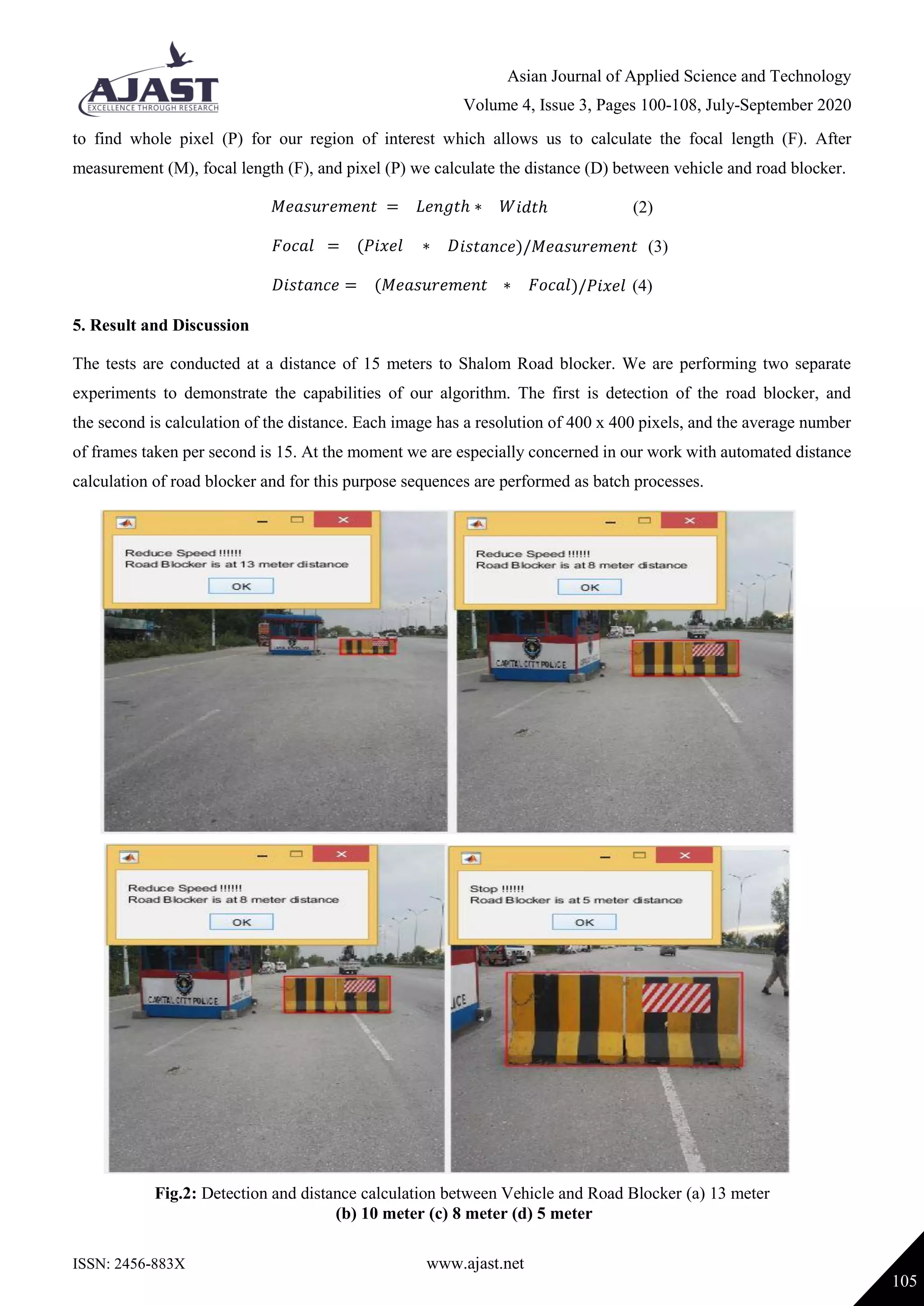
The paper discusses the development of a real-time road blocker detection and distance calculation system for autonomous vehicles using computer vision techniques. It outlines a proposed methodology involving pre-processing, color segmentation, post-processing, and distance calculation, achieving high accuracy and precision rates in detecting road blockers and measuring distances. Various experiments demonstrated the system's effectiveness, indicating significant advancements in autonomous vehicle navigation and safety.