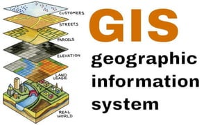
3. what is gis ?
GEOGRAPHIC
implies that locations of the data items are known, or can be
calculated, in terms of Geographic co-ordinated(latitude,longitude)
INFORMATION
implies that the data in a GIS are organized to yield useful l
knowledge,often as colored maps and images,but also as
statistical graphics,tables,and various on-screen responses
to interactive queries.
SYSTEM
implies that as GIS is made up from several inter-related and linked
component with different functions. thus,GIS have functinal
capabilities for data capture,input,manipulation,transformation,
visualization,combination,query,analysis,modelling and output.
4. WHAT IS GIS?
where is it?
what else is nearby?
where is the highest concentration of 'x'?
where can i find things with characteristic 'y'?
where is the closest 'z' to my location?
GIS = Geographic Information System
-links databases and maps
-Manages information about places
-Helps answer question such as :
5. GIS
Geographical information system (GIS) is basically
defined as a systematic integration of hardware
and software for capturing, storing, displaying,
updating manipulating and analyzing spatial data.
A technology hardware and software tools
An information handling strategy
The objective : to improve overall decision making
6. Map making and geographic analysis are not new, but a GIS performs
these tasks better and faster than do the old manual methods. And,
before GIS technology, only a few people had the skills necessary to use
geographic information to help with decision making and problem
solving.
GIS
7. Why is GIS unique?
GIS handles SPATIAL information
GIS makes connection between activities
-information referenced by its location in space
based on spatial proximity.
10. COMPONENTS OF A GIS
A working GIS integrates five key components: hardware, software, data, people, and
methods.
Hardware : it consists of a computer system on which the GIS software will run.
Software: GIS software provides the functions and tools needed to store,
analyze, and display geographic information.
People: GIS users range from technical specialists who design and maintain the
system to those who use it to help them perform their everyday work.
Method: a successful GIS operates according to a welldesigned plan and
business rules, which are the models and operating practices unique to each
organizations.
Data: Geographic data and related tabular data that can be collected in-
house. Digital map forms the basic data input for GIS
11. Data Types in GIS
The data in a GIS can be classified into two main categories:
1. Spatial data
Describes the absolute and relative location of geographic features.
2. Attribute data or Non-spatial data
Describes characteristics of the spatial features. These characteristics
can be quantitative and/or qualitative in nature.
12. The Data Model
Data model is a conceptual description (mental model) of how
spatial data are organized for use by the GIS.
The data model represents a set of guidelines to convert the real
world (called entity) to the digitally and logically represented spatial
objects consisting of the attributes and geometry.
The attributes are managed by thematic or semantic structure while
the geometry is represented by geometric-topological structure.
13. There are two major types of geometric data model ; vector and raster
model.
a. Vector Model Vector model uses discrete points, lines and/or areas
corresponding to discrete objects with name or code number of
attributes.
b. Raster Model Raster model uses regularly spaced grid cells in specfic
sequence. An element of the grid cell is called a pixel (picture cell). The
conventional sequence is row by row from the left to the right and then
line by line from the top to bottom. Every location is given in two
dimensional image coordinates ; pixel number and line number, which
contains a single value of attributes.
14.
15.
16. Professionals in just about any industry can benefit from GIS technology. Here are some of the
most popular examples of industries that use GIS.
Industries That Use GIS Data
Supply Chain – Being able to track inventory shipments can make the
supply chain more effective, thus saving money for businesses.
Insurance – Having the ability to accurately determine risk is vital for
insurance companies. GIS can identify areas that are more likely to
experience earthquakes, floods, or other natural disasters, as well as identify
areas with higher crime rates.
Forestry – GIS systems can collect data to help preserve ecosystems by
identifying species in certain areas, changes in animal populations, and
mapping out things like annual rainfall, temperatures, and the severity and
length of dry seasons.
17. Urban Planning – GIS helps planners better understand the needs of
their city. It allows them to design the city to fill those needs in a way
that will benefit it’s businesses and residents.
Banking – Banks can use GIS to determine where their branches
locations should be or what branches they should close to increase
profitability. It can also help them decide what products are best
suited for their demographics.
Public Health – Public health offices can use GIS to identify areas at
risk for certain diseases. Using this data, they can deploy awareness
campaigns to help educate the citizens of a particular area at risk.
Industries That Use GIS Data