SlideShare a Scribd company logo
In Gangwon Province, the rainy season with an extremely high precipitation caused extreme
flood event in the summer in 2006. A one dimensional (1D) hydraulic model was developed for
mountainous river reaches located closely to the Yeongwol thermal power plant. Input data,
including topographical data and river flow measured every 10 minutes from July 1st to September
30th, 2013 by Han River Flood Control Office (HRFCO), were imported to a 1D hydraulic model.
The results were the simulated water levels, water discharges and average flow velocities at each
cross-section. The simulated water levels in different years (including 2011, 2012 and 2014) were
used to calibrate and validate the applied model. Climate change scenarios were estimated by
referencing the climate change adaptation strategies of the Korean government and historical
information about the extreme flood events.
Scenario Strategy Upper Namhan Flow Dong River Flow
Sce.1
Do nothing
Normal (Q2013)
Extremely High
(Q = Q2006)
Sce.2 High (2 x Q2013)
Sce.3 Extremely High (3 x Q2013)
Sce.4
River-bed
widening
Normal (Q2013)
Sce.5 High (2 x Q2013)
Sce.6 Extremely High (3 x Q2013)
Scenario Sce.1 Sce.2 Sce.3 Sce.4 Sce.5 Sce.6
Reservoir A 5.6 6.5 6.9 8.7 10.0 10.4
Reservoir B 94.4 93.5 93.1 91.3 90.0 89.6
Prediction of Flood Risk under the Impact of Climate Change on the Thermal Power Plant
using One Dimensional Hydraulic Model
Nguyen Thanh Tuu1, Seungdo Kim1*, Van Pham Dang Tri2, Hyeonkyeong Kim3, Jeejae Lim1, Taeho Kim1, Beomsik Yu1, Cheongyu Park1
1 Department of Environmental Science and Biotechnology, College of Natural Sciences, Hallym University, South Korea
2 Department of Water Resources, College of Environment and Natural Resources, Can Tho University, Vietnam
3 Division of Information and Telecommunications, Hanshin University, South Korea
* Corresponding author, E-mail: sdkim@hallym.ac.kr
1. Introduction
2. Methodology
Table 1. Climate Change and Adaptation Strategy Scenarios
Table 2. Distribution of Flow to the Two Reservoirs (%)
Fig. 5. Maximum Velocities in the Part of River near Power Plant
1. Model Description
• Geometric data: 3 Stream lines
(Dong River, upper and lower
Namhan Rivers), 81 Cross-sections
created from 90m resolution digital
elevation model (DEM)
• Upstream boundaries: Stream flows
from Dong River and upper Namhan
River (Source: HRFCO).
• Downstream boundary: Friction
slope at lower Namhan River is
0.001.
• Manning’s n coefficient is 0.036 in
the mainstream lines for all rivers.
• Reservoirs: A (upper Namhan River)
and B (lower Namhan River).
• Program: HEC-RAS 5.0
2. Calibration and Validation
• Nash-Sutcliffe coefficient: R2 ranged
from 0.96 to .099
3. Results
1. Simulated Surface Elevations
• The highest elevation in 2013 is 193.3m, and the lowest elevation in 2014 is 186.9m, above mean
sea level (AMSL).
• The maximum velocity is ranged from 1.8 m.s-1 (2014) to 3.6 m.s-1 (2013).
• The depths in 2011 and 2012 are 191.7 m and 189.3m, respectively.
• Road elevation (RE): 195m; Power plant ground elevation (PPGE): 197m
Fig. 3. Maximum Surface Water Elevations from 2011 to 2014 (Max WS: Maximum
Water Surface Elevation)
• The inundation depths under Sce.1, Sce.4 and Sce.5 do not affect the power plant.
• Sce.2 and Sce.3 affect the power plant with the maximum depth are 0.43m and 1.52m above the
PPGE respectively.
• Despite widening the river-bed, Sce.6 still impacts on the PPGE with the maximum depth is
0.34m.
Fig. 4. Simulated Water Surface Elevations under Climate Change Scenarios
2. Velocities
• After widening the river bed, the velocities are reduced.
• Most of the maximum velocities under Sce.4 < Sce.1; Sce.5 < Sce.2; and, Sce.6 < Sce.3.
3. Lateral flows from the rivers to reservoirs
The percentage of distribution to reservoir A increases after widening (i.e. Sce.4 > Sce.1; Sce.5 >
Sce.2; and Sce.6 > Sce.3) and increasing upper Namhan River flow.
• The river-bed widening is an effective strategy for flood prevention for both road and power
plant in the case that the water flow at Dong River is extremely high (Q2006) and the flow at
upper Namhan River is normal (Q2013).
• River-bed widening can help reduce the water flow velocities
• The impact of high flow at upper Namhan River is more significant than Dong River.
• The widening strategy also helps to regulate flooding flow to the reservoirs.
4. Conclusions
Fig. 2. Model Calibration and Validation
Fig. 1. Geometric Data
43
40
This research was supported by a grant (17IFIP-B113506-02) from development of plant
program funded by Ministry of Land, Infrastructure and Transport of Korean government.
Acknowledgement

More Related Content

What's hot

GROUNDWATER MODELING SYSTEM
GROUNDWATER MODELING SYSTEMGROUNDWATER MODELING SYSTEM
GROUNDWATER MODELING SYSTEM
Shyam Mohan Chaudhary
 
Ganga Environmental Flow Calculator and its Applications
Ganga Environmental Flow Calculator and its ApplicationsGanga Environmental Flow Calculator and its Applications
Ganga Environmental Flow Calculator and its Applications
International Water Management Institute (IWMI)
 
Gis based-hydrological-modeling.-a-comparative-study-of-hec-hms-and-the-xinan...
Gis based-hydrological-modeling.-a-comparative-study-of-hec-hms-and-the-xinan...Gis based-hydrological-modeling.-a-comparative-study-of-hec-hms-and-the-xinan...
Gis based-hydrological-modeling.-a-comparative-study-of-hec-hms-and-the-xinan...Sikandar Ali
 
River flood modelling with mike 11 case of nzoia river (budalangi) in kenya
River flood modelling with mike 11 case of nzoia river (budalangi) in kenyaRiver flood modelling with mike 11 case of nzoia river (budalangi) in kenya
River flood modelling with mike 11 case of nzoia river (budalangi) in kenyaAlexander Decker
 
Arun b shrestha
Arun b shresthaArun b shrestha
Arun b shresthaClimDev15
 
Ann in water level prediction
Ann in water level prediction Ann in water level prediction
Ann in water level prediction
Shyam Mohan Chaudhary
 
Runoff modelling using hec hms for rural watershed
Runoff modelling using hec hms for rural watershedRunoff modelling using hec hms for rural watershed
Runoff modelling using hec hms for rural watershed
EditorIJAERD
 
Hydrology and hydraulics for design design
Hydrology and hydraulics for design designHydrology and hydraulics for design design
Hydrology and hydraulics for design design
avirup naskar
 
Flood Mapping via HEC-RAS Model and ArcGIS
Flood Mapping via HEC-RAS Model and ArcGISFlood Mapping via HEC-RAS Model and ArcGIS
Flood Mapping via HEC-RAS Model and ArcGIS
Lengthong KIM
 
2016 conservation track: automated river classification using gis delineated ...
2016 conservation track: automated river classification using gis delineated ...2016 conservation track: automated river classification using gis delineated ...
2016 conservation track: automated river classification using gis delineated ...
GIS in the Rockies
 
Watertech Booth Slide 2013
Watertech Booth Slide 2013Watertech Booth Slide 2013
Watertech Booth Slide 2013
Dirk Kassenaar M.Sc. P.Eng.
 
Applications of Integrated Surface Water Groundwater Modelling Techniques and...
Applications of Integrated Surface Water Groundwater Modelling Techniques and...Applications of Integrated Surface Water Groundwater Modelling Techniques and...
Applications of Integrated Surface Water Groundwater Modelling Techniques and...
Dirk Kassenaar M.Sc. P.Eng.
 
The Development of a Catchment Management Modelling System for the Googong Re...
The Development of a Catchment Management Modelling System for the Googong Re...The Development of a Catchment Management Modelling System for the Googong Re...
The Development of a Catchment Management Modelling System for the Googong Re...
GavanThomas
 
Concurrent session 7 hec rts
Concurrent session 7 hec rtsConcurrent session 7 hec rts
Concurrent session 7 hec rtsSikandar Ali
 
The Hydrological Functioning of the Watershed of Lake Laya- El Hammam, East o...
The Hydrological Functioning of the Watershed of Lake Laya- El Hammam, East o...The Hydrological Functioning of the Watershed of Lake Laya- El Hammam, East o...
The Hydrological Functioning of the Watershed of Lake Laya- El Hammam, East o...
International Journal of Innovation Engineering and Science Research
 
2016 conservation track: evaluating lidar derived synthetic streams as a ...
2016 conservation track: evaluating   lidar derived   synthetic streams as a ...2016 conservation track: evaluating   lidar derived   synthetic streams as a ...
2016 conservation track: evaluating lidar derived synthetic streams as a ...
GIS in the Rockies
 
Analysis of Low Impact Development (LID) Strategies using Fully-Integrated Fu...
Analysis of Low Impact Development (LID) Strategies using Fully-Integrated Fu...Analysis of Low Impact Development (LID) Strategies using Fully-Integrated Fu...
Analysis of Low Impact Development (LID) Strategies using Fully-Integrated Fu...
Dirk Kassenaar M.Sc. P.Eng.
 
Online Watershed Analysis Tool
Online Watershed Analysis Tool Online Watershed Analysis Tool
Online Watershed Analysis Tool
Malla Reddy University
 
Evaluation Of Low Impact Developments (LID)
Evaluation Of Low Impact Developments (LID)Evaluation Of Low Impact Developments (LID)
Evaluation Of Low Impact Developments (LID)Dawit A. Melaku
 

What's hot (20)

GROUNDWATER MODELING SYSTEM
GROUNDWATER MODELING SYSTEMGROUNDWATER MODELING SYSTEM
GROUNDWATER MODELING SYSTEM
 
Ganga Environmental Flow Calculator and its Applications
Ganga Environmental Flow Calculator and its ApplicationsGanga Environmental Flow Calculator and its Applications
Ganga Environmental Flow Calculator and its Applications
 
Gis based-hydrological-modeling.-a-comparative-study-of-hec-hms-and-the-xinan...
Gis based-hydrological-modeling.-a-comparative-study-of-hec-hms-and-the-xinan...Gis based-hydrological-modeling.-a-comparative-study-of-hec-hms-and-the-xinan...
Gis based-hydrological-modeling.-a-comparative-study-of-hec-hms-and-the-xinan...
 
Mandal
MandalMandal
Mandal
 
River flood modelling with mike 11 case of nzoia river (budalangi) in kenya
River flood modelling with mike 11 case of nzoia river (budalangi) in kenyaRiver flood modelling with mike 11 case of nzoia river (budalangi) in kenya
River flood modelling with mike 11 case of nzoia river (budalangi) in kenya
 
Arun b shrestha
Arun b shresthaArun b shrestha
Arun b shrestha
 
Ann in water level prediction
Ann in water level prediction Ann in water level prediction
Ann in water level prediction
 
Runoff modelling using hec hms for rural watershed
Runoff modelling using hec hms for rural watershedRunoff modelling using hec hms for rural watershed
Runoff modelling using hec hms for rural watershed
 
Hydrology and hydraulics for design design
Hydrology and hydraulics for design designHydrology and hydraulics for design design
Hydrology and hydraulics for design design
 
Flood Mapping via HEC-RAS Model and ArcGIS
Flood Mapping via HEC-RAS Model and ArcGISFlood Mapping via HEC-RAS Model and ArcGIS
Flood Mapping via HEC-RAS Model and ArcGIS
 
2016 conservation track: automated river classification using gis delineated ...
2016 conservation track: automated river classification using gis delineated ...2016 conservation track: automated river classification using gis delineated ...
2016 conservation track: automated river classification using gis delineated ...
 
Watertech Booth Slide 2013
Watertech Booth Slide 2013Watertech Booth Slide 2013
Watertech Booth Slide 2013
 
Applications of Integrated Surface Water Groundwater Modelling Techniques and...
Applications of Integrated Surface Water Groundwater Modelling Techniques and...Applications of Integrated Surface Water Groundwater Modelling Techniques and...
Applications of Integrated Surface Water Groundwater Modelling Techniques and...
 
The Development of a Catchment Management Modelling System for the Googong Re...
The Development of a Catchment Management Modelling System for the Googong Re...The Development of a Catchment Management Modelling System for the Googong Re...
The Development of a Catchment Management Modelling System for the Googong Re...
 
Concurrent session 7 hec rts
Concurrent session 7 hec rtsConcurrent session 7 hec rts
Concurrent session 7 hec rts
 
The Hydrological Functioning of the Watershed of Lake Laya- El Hammam, East o...
The Hydrological Functioning of the Watershed of Lake Laya- El Hammam, East o...The Hydrological Functioning of the Watershed of Lake Laya- El Hammam, East o...
The Hydrological Functioning of the Watershed of Lake Laya- El Hammam, East o...
 
2016 conservation track: evaluating lidar derived synthetic streams as a ...
2016 conservation track: evaluating   lidar derived   synthetic streams as a ...2016 conservation track: evaluating   lidar derived   synthetic streams as a ...
2016 conservation track: evaluating lidar derived synthetic streams as a ...
 
Analysis of Low Impact Development (LID) Strategies using Fully-Integrated Fu...
Analysis of Low Impact Development (LID) Strategies using Fully-Integrated Fu...Analysis of Low Impact Development (LID) Strategies using Fully-Integrated Fu...
Analysis of Low Impact Development (LID) Strategies using Fully-Integrated Fu...
 
Online Watershed Analysis Tool
Online Watershed Analysis Tool Online Watershed Analysis Tool
Online Watershed Analysis Tool
 
Evaluation Of Low Impact Developments (LID)
Evaluation Of Low Impact Developments (LID)Evaluation Of Low Impact Developments (LID)
Evaluation Of Low Impact Developments (LID)
 

Similar to Prediction of Flood Risk under the Impact of Climate Change on the Thermal Power Plant using One Dimensional Hydraulic Model

01 0804
01 080401 0804
01 0804
Tuu Nguyen
 
THE APPLICATION OF MATHEMATICAL MODELS IN MANAGEMENT OF AQUIFER
THE APPLICATION OF MATHEMATICAL MODELS IN MANAGEMENT OF AQUIFERTHE APPLICATION OF MATHEMATICAL MODELS IN MANAGEMENT OF AQUIFER
THE APPLICATION OF MATHEMATICAL MODELS IN MANAGEMENT OF AQUIFER
AnonymouslVQ83F8mC
 
THE APPLICATION OF MATHEMATICAL MODELS IN MANAGEMENT OF AQUIFER
THE APPLICATION OF MATHEMATICAL MODELS IN MANAGEMENT OF AQUIFERTHE APPLICATION OF MATHEMATICAL MODELS IN MANAGEMENT OF AQUIFER
THE APPLICATION OF MATHEMATICAL MODELS IN MANAGEMENT OF AQUIFER
amsjournal
 
THE APPLICATION OF MATHEMATICAL MODELS IN MANAGEMENT OF AQUIFER
THE APPLICATION OF MATHEMATICAL MODELS IN MANAGEMENT OF AQUIFERTHE APPLICATION OF MATHEMATICAL MODELS IN MANAGEMENT OF AQUIFER
THE APPLICATION OF MATHEMATICAL MODELS IN MANAGEMENT OF AQUIFER
pijans
 
THE APPLICATION OF MATHEMATICAL MODELS IN MANAGEMENT OF AQUIFER
THE APPLICATION OF MATHEMATICAL MODELS IN MANAGEMENT OF AQUIFERTHE APPLICATION OF MATHEMATICAL MODELS IN MANAGEMENT OF AQUIFER
THE APPLICATION OF MATHEMATICAL MODELS IN MANAGEMENT OF AQUIFER
pijans
 
THE APPLICATION OF MATHEMATICAL MODELS IN MANAGEMENT OF AQUIFER
THE APPLICATION OF MATHEMATICAL MODELS IN MANAGEMENT OF AQUIFERTHE APPLICATION OF MATHEMATICAL MODELS IN MANAGEMENT OF AQUIFER
THE APPLICATION OF MATHEMATICAL MODELS IN MANAGEMENT OF AQUIFER
pijans
 
THE APPLICATION OF MATHEMATICAL MODELS IN MANAGEMENT OF AQUIFER
THE APPLICATION OF MATHEMATICAL MODELS IN MANAGEMENT OF AQUIFERTHE APPLICATION OF MATHEMATICAL MODELS IN MANAGEMENT OF AQUIFER
THE APPLICATION OF MATHEMATICAL MODELS IN MANAGEMENT OF AQUIFER
amsjournal1
 
Using Hec Ras For Analysus of Flood Characteristic
Using Hec Ras For Analysus of Flood CharacteristicUsing Hec Ras For Analysus of Flood Characteristic
Using Hec Ras For Analysus of Flood Characteristic
Lucia797414
 
Flood risk evaluation for Serio river, Italy
Flood risk evaluation for Serio river, ItalyFlood risk evaluation for Serio river, Italy
Flood risk evaluation for Serio river, Italy
Maryam Izadifar
 
River hydraulic modelling for river Serio (Northern Italy), 2014
River hydraulic modelling for river Serio (Northern Italy), 2014River hydraulic modelling for river Serio (Northern Italy), 2014
River hydraulic modelling for river Serio (Northern Italy), 2014
Alireza Babaee
 
Paper for EWRI 2006
Paper for EWRI 2006Paper for EWRI 2006
Paper for EWRI 2006RFDMC/MRC
 
Determination of design discharge and environmental flow in micro-hydropower ...
Determination of design discharge and environmental flow in micro-hydropower ...Determination of design discharge and environmental flow in micro-hydropower ...
Determination of design discharge and environmental flow in micro-hydropower ...
Daniel Ngoma
 
Overbank Flow Condition in a River Section
Overbank Flow Condition in a River SectionOverbank Flow Condition in a River Section
Overbank Flow Condition in a River Section
IDES Editor
 
SImulating Past Flood Event using Nays 2D Flood
SImulating Past Flood Event using Nays 2D FloodSImulating Past Flood Event using Nays 2D Flood
SImulating Past Flood Event using Nays 2D Flood
Putika Ashfar Khoiri
 
The stream power variation in a GIS environment as an index to evaluate the m...
The stream power variation in a GIS environment as an index to evaluate the m...The stream power variation in a GIS environment as an index to evaluate the m...
The stream power variation in a GIS environment as an index to evaluate the m...
pierluigi de rosa
 
Identify saltwater intrusion in coastal aquifer
Identify saltwater intrusion in coastal aquiferIdentify saltwater intrusion in coastal aquifer
Identify saltwater intrusion in coastal aquifer
Putika Ashfar Khoiri
 
VNMC Mekong Dam Study: Modelling
VNMC Mekong Dam Study: ModellingVNMC Mekong Dam Study: Modelling
VNMC Mekong Dam Study: Modelling
Water, Land and Ecosystems (WLE)
 
Applicability Study on the Optical Remote Sensing Techniques in a River
Applicability Study on the Optical Remote Sensing Techniques in a RiverApplicability Study on the Optical Remote Sensing Techniques in a River
Applicability Study on the Optical Remote Sensing Techniques in a River
International Journal of Modern Research in Engineering and Technology
 
Final Ppt.pdf
Final Ppt.pdfFinal Ppt.pdf
Final Ppt.pdf
YuvvrajSingh3
 

Similar to Prediction of Flood Risk under the Impact of Climate Change on the Thermal Power Plant using One Dimensional Hydraulic Model (20)

01 0804
01 080401 0804
01 0804
 
THE APPLICATION OF MATHEMATICAL MODELS IN MANAGEMENT OF AQUIFER
THE APPLICATION OF MATHEMATICAL MODELS IN MANAGEMENT OF AQUIFERTHE APPLICATION OF MATHEMATICAL MODELS IN MANAGEMENT OF AQUIFER
THE APPLICATION OF MATHEMATICAL MODELS IN MANAGEMENT OF AQUIFER
 
THE APPLICATION OF MATHEMATICAL MODELS IN MANAGEMENT OF AQUIFER
THE APPLICATION OF MATHEMATICAL MODELS IN MANAGEMENT OF AQUIFERTHE APPLICATION OF MATHEMATICAL MODELS IN MANAGEMENT OF AQUIFER
THE APPLICATION OF MATHEMATICAL MODELS IN MANAGEMENT OF AQUIFER
 
THE APPLICATION OF MATHEMATICAL MODELS IN MANAGEMENT OF AQUIFER
THE APPLICATION OF MATHEMATICAL MODELS IN MANAGEMENT OF AQUIFERTHE APPLICATION OF MATHEMATICAL MODELS IN MANAGEMENT OF AQUIFER
THE APPLICATION OF MATHEMATICAL MODELS IN MANAGEMENT OF AQUIFER
 
THE APPLICATION OF MATHEMATICAL MODELS IN MANAGEMENT OF AQUIFER
THE APPLICATION OF MATHEMATICAL MODELS IN MANAGEMENT OF AQUIFERTHE APPLICATION OF MATHEMATICAL MODELS IN MANAGEMENT OF AQUIFER
THE APPLICATION OF MATHEMATICAL MODELS IN MANAGEMENT OF AQUIFER
 
THE APPLICATION OF MATHEMATICAL MODELS IN MANAGEMENT OF AQUIFER
THE APPLICATION OF MATHEMATICAL MODELS IN MANAGEMENT OF AQUIFERTHE APPLICATION OF MATHEMATICAL MODELS IN MANAGEMENT OF AQUIFER
THE APPLICATION OF MATHEMATICAL MODELS IN MANAGEMENT OF AQUIFER
 
THE APPLICATION OF MATHEMATICAL MODELS IN MANAGEMENT OF AQUIFER
THE APPLICATION OF MATHEMATICAL MODELS IN MANAGEMENT OF AQUIFERTHE APPLICATION OF MATHEMATICAL MODELS IN MANAGEMENT OF AQUIFER
THE APPLICATION OF MATHEMATICAL MODELS IN MANAGEMENT OF AQUIFER
 
Using Hec Ras For Analysus of Flood Characteristic
Using Hec Ras For Analysus of Flood CharacteristicUsing Hec Ras For Analysus of Flood Characteristic
Using Hec Ras For Analysus of Flood Characteristic
 
Flood risk evaluation for Serio river, Italy
Flood risk evaluation for Serio river, ItalyFlood risk evaluation for Serio river, Italy
Flood risk evaluation for Serio river, Italy
 
River hydraulic modelling for river Serio (Northern Italy), 2014
River hydraulic modelling for river Serio (Northern Italy), 2014River hydraulic modelling for river Serio (Northern Italy), 2014
River hydraulic modelling for river Serio (Northern Italy), 2014
 
Paper for EWRI 2006
Paper for EWRI 2006Paper for EWRI 2006
Paper for EWRI 2006
 
Determination of design discharge and environmental flow in micro-hydropower ...
Determination of design discharge and environmental flow in micro-hydropower ...Determination of design discharge and environmental flow in micro-hydropower ...
Determination of design discharge and environmental flow in micro-hydropower ...
 
Overbank Flow Condition in a River Section
Overbank Flow Condition in a River SectionOverbank Flow Condition in a River Section
Overbank Flow Condition in a River Section
 
SImulating Past Flood Event using Nays 2D Flood
SImulating Past Flood Event using Nays 2D FloodSImulating Past Flood Event using Nays 2D Flood
SImulating Past Flood Event using Nays 2D Flood
 
The stream power variation in a GIS environment as an index to evaluate the m...
The stream power variation in a GIS environment as an index to evaluate the m...The stream power variation in a GIS environment as an index to evaluate the m...
The stream power variation in a GIS environment as an index to evaluate the m...
 
Identify saltwater intrusion in coastal aquifer
Identify saltwater intrusion in coastal aquiferIdentify saltwater intrusion in coastal aquifer
Identify saltwater intrusion in coastal aquifer
 
VNMC Mekong Dam Study: Modelling
VNMC Mekong Dam Study: ModellingVNMC Mekong Dam Study: Modelling
VNMC Mekong Dam Study: Modelling
 
CE573_Poster2
CE573_Poster2CE573_Poster2
CE573_Poster2
 
Applicability Study on the Optical Remote Sensing Techniques in a River
Applicability Study on the Optical Remote Sensing Techniques in a RiverApplicability Study on the Optical Remote Sensing Techniques in a River
Applicability Study on the Optical Remote Sensing Techniques in a River
 
Final Ppt.pdf
Final Ppt.pdfFinal Ppt.pdf
Final Ppt.pdf
 

More from Tuu Nguyen

Tuu HEC-RAS guideline
Tuu HEC-RAS guidelineTuu HEC-RAS guideline
Tuu HEC-RAS guideline
Tuu Nguyen
 
Nh trung gisideas_2014_uw
Nh trung gisideas_2014_uwNh trung gisideas_2014_uw
Nh trung gisideas_2014_uw
Tuu Nguyen
 
Trongtruong so27a 13
Trongtruong so27a 13Trongtruong so27a 13
Trongtruong so27a 13
Tuu Nguyen
 
Dong thai dong chay tren he thong song chinh vung ha luu song tien duoi tac d...
Dong thai dong chay tren he thong song chinh vung ha luu song tien duoi tac d...Dong thai dong chay tren he thong song chinh vung ha luu song tien duoi tac d...
Dong thai dong chay tren he thong song chinh vung ha luu song tien duoi tac d...
Tuu Nguyen
 
01
0101
Luan van (tuu) 26 11-2012-b
Luan van (tuu) 26 11-2012-bLuan van (tuu) 26 11-2012-b
Luan van (tuu) 26 11-2012-b
Tuu Nguyen
 

More from Tuu Nguyen (6)

Tuu HEC-RAS guideline
Tuu HEC-RAS guidelineTuu HEC-RAS guideline
Tuu HEC-RAS guideline
 
Nh trung gisideas_2014_uw
Nh trung gisideas_2014_uwNh trung gisideas_2014_uw
Nh trung gisideas_2014_uw
 
Trongtruong so27a 13
Trongtruong so27a 13Trongtruong so27a 13
Trongtruong so27a 13
 
Dong thai dong chay tren he thong song chinh vung ha luu song tien duoi tac d...
Dong thai dong chay tren he thong song chinh vung ha luu song tien duoi tac d...Dong thai dong chay tren he thong song chinh vung ha luu song tien duoi tac d...
Dong thai dong chay tren he thong song chinh vung ha luu song tien duoi tac d...
 
01
0101
01
 
Luan van (tuu) 26 11-2012-b
Luan van (tuu) 26 11-2012-bLuan van (tuu) 26 11-2012-b
Luan van (tuu) 26 11-2012-b
 

Recently uploaded

Sustainable Rain water harvesting in india.ppt
Sustainable Rain water harvesting in india.pptSustainable Rain water harvesting in india.ppt
Sustainable Rain water harvesting in india.ppt
chaitaliambole
 
Climate Change All over the World .pptx
Climate Change All over the World  .pptxClimate Change All over the World  .pptx
Climate Change All over the World .pptx
sairaanwer024
 
UNDERSTANDING WHAT GREEN WASHING IS!.pdf
UNDERSTANDING WHAT GREEN WASHING IS!.pdfUNDERSTANDING WHAT GREEN WASHING IS!.pdf
UNDERSTANDING WHAT GREEN WASHING IS!.pdf
JulietMogola
 
alhambra case study Islamic gardens part-2.pptx
alhambra case study Islamic gardens part-2.pptxalhambra case study Islamic gardens part-2.pptx
alhambra case study Islamic gardens part-2.pptx
CECOS University Peshawar, Pakistan
 
Characterization and the Kinetics of drying at the drying oven and with micro...
Characterization and the Kinetics of drying at the drying oven and with micro...Characterization and the Kinetics of drying at the drying oven and with micro...
Characterization and the Kinetics of drying at the drying oven and with micro...
Open Access Research Paper
 
Q&A with the Experts: The Food Service Playbook
Q&A with the Experts: The Food Service PlaybookQ&A with the Experts: The Food Service Playbook
Q&A with the Experts: The Food Service Playbook
World Resources Institute (WRI)
 
growbilliontrees.com-Trees for Granddaughter (1).pdf
growbilliontrees.com-Trees for Granddaughter (1).pdfgrowbilliontrees.com-Trees for Granddaughter (1).pdf
growbilliontrees.com-Trees for Granddaughter (1).pdf
yadavakashagra
 
Summary of the Climate and Energy Policy of Australia
Summary of the Climate and Energy Policy of AustraliaSummary of the Climate and Energy Policy of Australia
Summary of the Climate and Energy Policy of Australia
yasmindemoraes1
 
How about Huawei mobile phone-www.cfye-commerce.shop
How about Huawei mobile phone-www.cfye-commerce.shopHow about Huawei mobile phone-www.cfye-commerce.shop
How about Huawei mobile phone-www.cfye-commerce.shop
laozhuseo02
 
Willie Nelson Net Worth: A Journey Through Music, Movies, and Business Ventures
Willie Nelson Net Worth: A Journey Through Music, Movies, and Business VenturesWillie Nelson Net Worth: A Journey Through Music, Movies, and Business Ventures
Willie Nelson Net Worth: A Journey Through Music, Movies, and Business Ventures
greendigital
 
Sustainable farming practices in India .pptx
Sustainable farming  practices in India .pptxSustainable farming  practices in India .pptx
Sustainable farming practices in India .pptx
chaitaliambole
 
Daan Park Hydrangea flower season I like it
Daan Park Hydrangea flower season I like itDaan Park Hydrangea flower season I like it
Daan Park Hydrangea flower season I like it
a0966109726
 
Presentación Giulio Quaggiotto-Diálogo improbable .pptx.pdf
Presentación Giulio Quaggiotto-Diálogo improbable .pptx.pdfPresentación Giulio Quaggiotto-Diálogo improbable .pptx.pdf
Presentación Giulio Quaggiotto-Diálogo improbable .pptx.pdf
Innovation and Technology for Development Centre
 
Prevalence of Toxoplasma gondii infection in domestic animals in District Ban...
Prevalence of Toxoplasma gondii infection in domestic animals in District Ban...Prevalence of Toxoplasma gondii infection in domestic animals in District Ban...
Prevalence of Toxoplasma gondii infection in domestic animals in District Ban...
Open Access Research Paper
 
Navigating the complex landscape of AI governance
Navigating the complex landscape of AI governanceNavigating the complex landscape of AI governance
Navigating the complex landscape of AI governance
Piermenotti Mauro
 
Alert-driven Community-based Forest monitoring: A case of the Peruvian Amazon
Alert-driven Community-based Forest monitoring: A case of the Peruvian AmazonAlert-driven Community-based Forest monitoring: A case of the Peruvian Amazon
Alert-driven Community-based Forest monitoring: A case of the Peruvian Amazon
CIFOR-ICRAF
 
一比一原版(UMTC毕业证书)明尼苏达大学双城分校毕业证如何办理
一比一原版(UMTC毕业证书)明尼苏达大学双城分校毕业证如何办理一比一原版(UMTC毕业证书)明尼苏达大学双城分校毕业证如何办理
一比一原版(UMTC毕业证书)明尼苏达大学双城分校毕业证如何办理
zm9ajxup
 
Artificial Reefs by Kuddle Life Foundation - May 2024
Artificial Reefs by Kuddle Life Foundation - May 2024Artificial Reefs by Kuddle Life Foundation - May 2024
Artificial Reefs by Kuddle Life Foundation - May 2024
punit537210
 
Celebrating World-environment-day-2024.pdf
Celebrating  World-environment-day-2024.pdfCelebrating  World-environment-day-2024.pdf
Celebrating World-environment-day-2024.pdf
rohankumarsinghrore1
 
ppt on beauty of the nature by Palak.pptx
ppt on  beauty of the nature by Palak.pptxppt on  beauty of the nature by Palak.pptx
ppt on beauty of the nature by Palak.pptx
RaniJaiswal16
 

Recently uploaded (20)

Sustainable Rain water harvesting in india.ppt
Sustainable Rain water harvesting in india.pptSustainable Rain water harvesting in india.ppt
Sustainable Rain water harvesting in india.ppt
 
Climate Change All over the World .pptx
Climate Change All over the World  .pptxClimate Change All over the World  .pptx
Climate Change All over the World .pptx
 
UNDERSTANDING WHAT GREEN WASHING IS!.pdf
UNDERSTANDING WHAT GREEN WASHING IS!.pdfUNDERSTANDING WHAT GREEN WASHING IS!.pdf
UNDERSTANDING WHAT GREEN WASHING IS!.pdf
 
alhambra case study Islamic gardens part-2.pptx
alhambra case study Islamic gardens part-2.pptxalhambra case study Islamic gardens part-2.pptx
alhambra case study Islamic gardens part-2.pptx
 
Characterization and the Kinetics of drying at the drying oven and with micro...
Characterization and the Kinetics of drying at the drying oven and with micro...Characterization and the Kinetics of drying at the drying oven and with micro...
Characterization and the Kinetics of drying at the drying oven and with micro...
 
Q&A with the Experts: The Food Service Playbook
Q&A with the Experts: The Food Service PlaybookQ&A with the Experts: The Food Service Playbook
Q&A with the Experts: The Food Service Playbook
 
growbilliontrees.com-Trees for Granddaughter (1).pdf
growbilliontrees.com-Trees for Granddaughter (1).pdfgrowbilliontrees.com-Trees for Granddaughter (1).pdf
growbilliontrees.com-Trees for Granddaughter (1).pdf
 
Summary of the Climate and Energy Policy of Australia
Summary of the Climate and Energy Policy of AustraliaSummary of the Climate and Energy Policy of Australia
Summary of the Climate and Energy Policy of Australia
 
How about Huawei mobile phone-www.cfye-commerce.shop
How about Huawei mobile phone-www.cfye-commerce.shopHow about Huawei mobile phone-www.cfye-commerce.shop
How about Huawei mobile phone-www.cfye-commerce.shop
 
Willie Nelson Net Worth: A Journey Through Music, Movies, and Business Ventures
Willie Nelson Net Worth: A Journey Through Music, Movies, and Business VenturesWillie Nelson Net Worth: A Journey Through Music, Movies, and Business Ventures
Willie Nelson Net Worth: A Journey Through Music, Movies, and Business Ventures
 
Sustainable farming practices in India .pptx
Sustainable farming  practices in India .pptxSustainable farming  practices in India .pptx
Sustainable farming practices in India .pptx
 
Daan Park Hydrangea flower season I like it
Daan Park Hydrangea flower season I like itDaan Park Hydrangea flower season I like it
Daan Park Hydrangea flower season I like it
 
Presentación Giulio Quaggiotto-Diálogo improbable .pptx.pdf
Presentación Giulio Quaggiotto-Diálogo improbable .pptx.pdfPresentación Giulio Quaggiotto-Diálogo improbable .pptx.pdf
Presentación Giulio Quaggiotto-Diálogo improbable .pptx.pdf
 
Prevalence of Toxoplasma gondii infection in domestic animals in District Ban...
Prevalence of Toxoplasma gondii infection in domestic animals in District Ban...Prevalence of Toxoplasma gondii infection in domestic animals in District Ban...
Prevalence of Toxoplasma gondii infection in domestic animals in District Ban...
 
Navigating the complex landscape of AI governance
Navigating the complex landscape of AI governanceNavigating the complex landscape of AI governance
Navigating the complex landscape of AI governance
 
Alert-driven Community-based Forest monitoring: A case of the Peruvian Amazon
Alert-driven Community-based Forest monitoring: A case of the Peruvian AmazonAlert-driven Community-based Forest monitoring: A case of the Peruvian Amazon
Alert-driven Community-based Forest monitoring: A case of the Peruvian Amazon
 
一比一原版(UMTC毕业证书)明尼苏达大学双城分校毕业证如何办理
一比一原版(UMTC毕业证书)明尼苏达大学双城分校毕业证如何办理一比一原版(UMTC毕业证书)明尼苏达大学双城分校毕业证如何办理
一比一原版(UMTC毕业证书)明尼苏达大学双城分校毕业证如何办理
 
Artificial Reefs by Kuddle Life Foundation - May 2024
Artificial Reefs by Kuddle Life Foundation - May 2024Artificial Reefs by Kuddle Life Foundation - May 2024
Artificial Reefs by Kuddle Life Foundation - May 2024
 
Celebrating World-environment-day-2024.pdf
Celebrating  World-environment-day-2024.pdfCelebrating  World-environment-day-2024.pdf
Celebrating World-environment-day-2024.pdf
 
ppt on beauty of the nature by Palak.pptx
ppt on  beauty of the nature by Palak.pptxppt on  beauty of the nature by Palak.pptx
ppt on beauty of the nature by Palak.pptx
 

Prediction of Flood Risk under the Impact of Climate Change on the Thermal Power Plant using One Dimensional Hydraulic Model

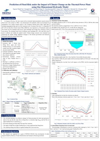
  • 1. In Gangwon Province, the rainy season with an extremely high precipitation caused extreme flood event in the summer in 2006. A one dimensional (1D) hydraulic model was developed for mountainous river reaches located closely to the Yeongwol thermal power plant. Input data, including topographical data and river flow measured every 10 minutes from July 1st to September 30th, 2013 by Han River Flood Control Office (HRFCO), were imported to a 1D hydraulic model. The results were the simulated water levels, water discharges and average flow velocities at each cross-section. The simulated water levels in different years (including 2011, 2012 and 2014) were used to calibrate and validate the applied model. Climate change scenarios were estimated by referencing the climate change adaptation strategies of the Korean government and historical information about the extreme flood events. Scenario Strategy Upper Namhan Flow Dong River Flow Sce.1 Do nothing Normal (Q2013) Extremely High (Q = Q2006) Sce.2 High (2 x Q2013) Sce.3 Extremely High (3 x Q2013) Sce.4 River-bed widening Normal (Q2013) Sce.5 High (2 x Q2013) Sce.6 Extremely High (3 x Q2013) Scenario Sce.1 Sce.2 Sce.3 Sce.4 Sce.5 Sce.6 Reservoir A 5.6 6.5 6.9 8.7 10.0 10.4 Reservoir B 94.4 93.5 93.1 91.3 90.0 89.6 Prediction of Flood Risk under the Impact of Climate Change on the Thermal Power Plant using One Dimensional Hydraulic Model Nguyen Thanh Tuu1, Seungdo Kim1*, Van Pham Dang Tri2, Hyeonkyeong Kim3, Jeejae Lim1, Taeho Kim1, Beomsik Yu1, Cheongyu Park1 1 Department of Environmental Science and Biotechnology, College of Natural Sciences, Hallym University, South Korea 2 Department of Water Resources, College of Environment and Natural Resources, Can Tho University, Vietnam 3 Division of Information and Telecommunications, Hanshin University, South Korea * Corresponding author, E-mail: sdkim@hallym.ac.kr 1. Introduction 2. Methodology Table 1. Climate Change and Adaptation Strategy Scenarios Table 2. Distribution of Flow to the Two Reservoirs (%) Fig. 5. Maximum Velocities in the Part of River near Power Plant 1. Model Description • Geometric data: 3 Stream lines (Dong River, upper and lower Namhan Rivers), 81 Cross-sections created from 90m resolution digital elevation model (DEM) • Upstream boundaries: Stream flows from Dong River and upper Namhan River (Source: HRFCO). • Downstream boundary: Friction slope at lower Namhan River is 0.001. • Manning’s n coefficient is 0.036 in the mainstream lines for all rivers. • Reservoirs: A (upper Namhan River) and B (lower Namhan River). • Program: HEC-RAS 5.0 2. Calibration and Validation • Nash-Sutcliffe coefficient: R2 ranged from 0.96 to .099 3. Results 1. Simulated Surface Elevations • The highest elevation in 2013 is 193.3m, and the lowest elevation in 2014 is 186.9m, above mean sea level (AMSL). • The maximum velocity is ranged from 1.8 m.s-1 (2014) to 3.6 m.s-1 (2013). • The depths in 2011 and 2012 are 191.7 m and 189.3m, respectively. • Road elevation (RE): 195m; Power plant ground elevation (PPGE): 197m Fig. 3. Maximum Surface Water Elevations from 2011 to 2014 (Max WS: Maximum Water Surface Elevation) • The inundation depths under Sce.1, Sce.4 and Sce.5 do not affect the power plant. • Sce.2 and Sce.3 affect the power plant with the maximum depth are 0.43m and 1.52m above the PPGE respectively. • Despite widening the river-bed, Sce.6 still impacts on the PPGE with the maximum depth is 0.34m. Fig. 4. Simulated Water Surface Elevations under Climate Change Scenarios 2. Velocities • After widening the river bed, the velocities are reduced. • Most of the maximum velocities under Sce.4 < Sce.1; Sce.5 < Sce.2; and, Sce.6 < Sce.3. 3. Lateral flows from the rivers to reservoirs The percentage of distribution to reservoir A increases after widening (i.e. Sce.4 > Sce.1; Sce.5 > Sce.2; and Sce.6 > Sce.3) and increasing upper Namhan River flow. • The river-bed widening is an effective strategy for flood prevention for both road and power plant in the case that the water flow at Dong River is extremely high (Q2006) and the flow at upper Namhan River is normal (Q2013). • River-bed widening can help reduce the water flow velocities • The impact of high flow at upper Namhan River is more significant than Dong River. • The widening strategy also helps to regulate flooding flow to the reservoirs. 4. Conclusions Fig. 2. Model Calibration and Validation Fig. 1. Geometric Data 43 40 This research was supported by a grant (17IFIP-B113506-02) from development of plant program funded by Ministry of Land, Infrastructure and Transport of Korean government. Acknowledgement