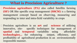
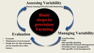
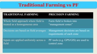
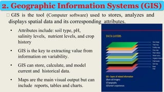
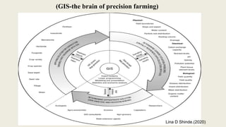
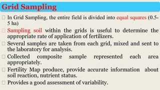
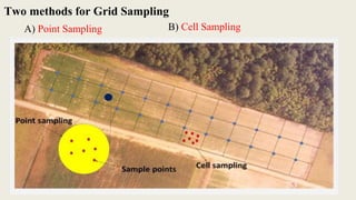
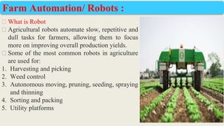
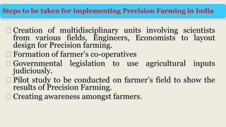
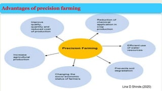
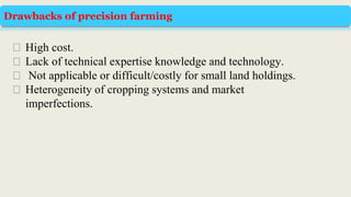
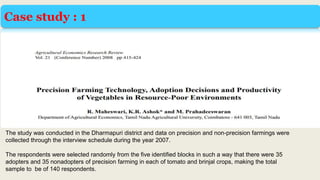
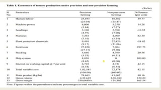
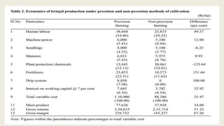
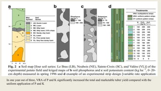
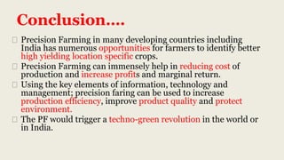
2. āPrecision farming and its impact in vegetable production.ā
Master Credit seminar on
Dr Rajendra Prasad Central Agricultural University
Pusa,Samastipur-484125,Bihar
Department of Horticulture
SEMINAR INCHARGE
Dr. Udit Kumar
Dr. A. K. Singh
Dr. Pramila
Asstt . Professor-cum-Scientist
Department of Horticulture
SPEAKER
Dhongade Somesh V.
M.Sc (Ag.) Vegetable Science
M/HORT/437/2019-20
Department of Horticulture
DRPCAU , PUSA
3. Precision Farming- Meaning & Concept
Basic steps in Precision Farming
Comparison between PF & Traditional Farming
Current Scenario
Need for Precision Farming
Objectives of Precision Farming
Content
4. Element of Precision Farming
Steps involved in PF adaption
Challenges faced by PF
Steps to be taken for implementing Precision Farming in India
Advantages & some drawbacks
Case studies & Conclusion
Content
5. ā® Precision agriculture (PA) also called Satellite farming
(SF) OR Site specific crop management (SSCM) is a farming
management concept based on observing, measuring and
responding to inter and intra-field variability in crops
ā® Precision agriculture is an art and science of utilizing
innovative, site- specific techniques for management of
spatial and temporal variability using affordable
technologiesā¦ for enhancing output, efficiency, and
profitability of agricultural production in an environmentally
responsible manner.
What is Precision Agriculture ?
6. Concept is Simpleā¦.
What ?
How much? When?
How to do? Where?
Precision
Farming
Precision Farming- Concept
In right quantity
Right Thing
in the right place
in the right way
at the right time
7. Basic
steps in
precision
Farming
Evaluation
Assessing Variability
Managing Variability
ā¢ Land leveling
ā¢ VRT
ā¢ Site specific planting
ā¢ Site Specific Nutrient Management
ā¢ Precision water management
ā¢ Site specific weed management
Remote Sensing,GPS,GIS,Yield Monitoring
ā¢ Economic
ā¢ Maintenance of environment
ā¢ Finally how far this technology
can be transferred to other
farmers
8. TRADITIONAL FARMING PRECISION FARMING
Whole field approach where field is
treated as a homogeneous area
Farm field is broken into
āmanagement zonesā
Decisions are based on field averages Management decisions are based on
requirements of each zone
Inputs are applied uniformly across a
field
PF tools (e.g. GPS/GIS) are used to
control zone
Traditional Farming vs PF
9. ā®PF adopted - USA, Europe, Canada and Australia.
ā® Agriculturally progressive states such as Punjab, Haryana, Gujarat &
Rajasthan, 20% of agricultural lands have operational holding of 4 ha
or more. (Talwar et al., 2005).
In India :
ā®Space Application Center (ISRO), Ahmedabad has started experiment
in the Central Potato Research Station farm at Jalhandhar, Punjab -
the role of remote sensing in mapping the variability with respect to
space and time.
Current Status of Precision Agriculture
10. ā®M S Swaminathan Research Foundation, Chennai + NABARD, has
adopted a village in Dindigul for VRT application.
ā®IARI, New Delhi has drawn up a plan to do precision farming
experiments in the institutesā farm.
ā®Project Directorate for Cropping Systems Research (PDCSR),
Modipuram and Meerut (UP) + Central Institute of Agricultural
Engineering (CIAE), Bhopal ā VRT In coming few years precision
farming may help the Indian farmers to harvest the fruits of frontier
technologies without compromising the quality of land.
Continueā¦..
12. Need for
precision
farming
Total Productivity decline
Diminishing and degrading
natural resources
Land degradation
Stagnating farm incomes
Declining and fragmented
land holdings
Depletion of Water resources
Global climatic variation
poverty alleviation
Enhance quality of life
Food security
13. Increased profitability &
sustainability
To increase production
efficiency
To reduce ecological
degradation
To improve product quality
Energy conservation
More efficient input use
Optimising production
efficiency
Surface and ground water
protection
Most efficient chemical and
seed use
Effective and efficient pest
Minimising environmental
impact
To improve status of farmer in
society
Objectives
of
Precision
Farming
15. ā® Crop characteristics like stage of crop, crop health,
nutrient requirement etc.
ā® Detailed soil layer with physical and chemical
properties, depth, texture, nutrient status, salinity and
toxicity, soil temperature, productivity potential etc.
ā® Microclimate data (season and daily) about the canopy
temperature, wind direction and speed, humidity etc.
ā® Surface and sub-surface drainage conditions.
ā® Irrigation facilities, water availability and other
planning inputs of interest.
A) Information
16. B) Technology :
Tools and
equipment
8)Computer
Hardware &
Software:
4) Variable
Rate
Technology
(VRT):
3) Grid
Sampling:
2) Geographic
Information
System (GIS):
1) Global
Positioning
System
(GPS):
5) Yield
Maps:
6) Remote
Sensors:
7) Proximate
Sensors:
9) Precision
irrigation
systems:
10) Auto-
guidance
systems
17. ā®All phases of
precision
agriculture require
positioning
information and it
can be provided by
the GPS.
1. Global Positioning System (GPS)
An instrument that receives satellite signals to calculate your
position (latitude, longitude and elevation).
www.remotesensing application in agriculture.com
18. ā® GPS provides the accurate positional information,
which is useful in locating the spatial variability with
accuracy
ā® This is the satellite-based information received by a
mobile field instrument sensitive to the transmitting
frequency.
ā®GPS help in identifying any location in the field to
assess the spatial variability and site specific
application of inputs.
19. ā® GIS is the tool (Computer software) used to stores, analyzes and
displays spatial data and its corresponding attributes.
2. Geographic Information Systems (GIS)
ā¢ Attributes include: soil type, pH,
salinity levels, nutrient levels, and crop
history
ā¢ GIS is the key to extracting value from
information on variability.
ā¢ GIS can store, calculate, and model
current and historical data.
ā¢ Maps are the main visual output but can
include reports, tables and charts.
21. ā® In Grid Sampling, the entire field is divided into equal squares (0.5-
5 ha)
ā® Sampling soil within the grids is useful to determine the
appropriate rate of application of fertilizers.
ā® Several samples are taken from each grid, mixed and sent to
the laboratory for analysis.
ā® Collected composite sample represented each area
appropriately.
ā® Fertility Map produce, provide accurate information about
soil reaction, nutrient status.
ā® Provides a good assessment of variability.
Grid Sampling
23. ā® Variable rate application (VRA) in precision agriculture is an area of
technology that focuses on the automated application of materials to a
given landscape.
ā® The way in which the materials are applied is based on data that is
collected by sensors, maps, and GPS.
ā® These materials include things like fertilizers, chemicals, and seeds, and
they all help optimize oneās crop production.
ā® During the creation of nutrient requirement map for VRT, profit
maximizing fertilizer rate should be considered more rather than yield
maximizing fertilizer rate.
Variable Rate Technology (VRT):
24. Multiple sources present various economic benefits of VRA
highlighted below
1. Savings on fertilizers and chemicals.
2. Based on a study at the University of Illinois, the farmers
can save about 5 USD per acre due to a VRA technology
for nitrogen fertilization.
Potential yield increase
Environmental protection from excess fertilisation or
spraying of chemicals.
25. ā® Varying the
application rates of
seed, fertilizer or
pesticides to adjust
for in-field
differences
ā® Historically,
intensive soil
sampling had
been necessary to
measure and
adjust for this
variation.
26. ā® Yield maps are produced by
processing data from adapted
combine harvester that is
equipped with a GPS, i.e.
integrated with a yield
recording system.
ā® Yield mapping involves the
recording of the grain flow
through the combine harvester,
while recording the actual
location in the field at the same
time.
Yield Maps
Www.Researchgate.Com
27. ā® Remote sensing has been used in soil mapping, terrain
analysis, crop stress, yield mapping and estimation of soil
organic matter, but on a scale larger than what is required for
precision agriculture.
ā® Remote sensing at high resolution can be of great use in
precision farming because of its capacity to monitor the spatial
variability.
ā® The role of satellite remote sensing in PF is to acquire
spatially- and temporally-distributed information to identify
and analyze crop and soil variability within fields.
Remote Sensing
28. 1. Energy Source or Illumination (A)
2. Radiation and the Atmosphere (B)
3. Interaction with the Object (C)
4. Recording of Energy by the Sensor (D)
5.Transmission, Reception and
Processing (E)
6. Interpretation and Analysis (F)
7. Application (G)
Elements of remote sensing
Lina D Shinde.(2020)
29. The specific application of remote sensing techniques
can be used for -
10. Effects of fertilizes
11. Soil toxicity
12. Soil moisture
13. Water quality
14. Irrigation requirement
15. Insect infestations
16. Disease infestations
17. Water availability
18. Location of canals
i) Detection ii) Identification iii) Measurement iv) Monitoring of agricultural
phenomena.
1. Crop identification
2. Crop acreage
3. Crop vigor
4. Crop density
5. Crop maturity
6. Growth rates
7. Yield forecasting
8. Actual yield
9. Soil fertility Applicable to crop
survey
30. ā®These sensors can be used to measure soil parameters
such as N status and soil pH and crop properties as the
sensor attached tractor passes over the field.
ā®The soil sample is scooped, pressed against an
electrode, stabilization period of about 10-15 seconds
allowed, and the reading taken.
Proximate Sensors
31. ā®In order to analyze the data collected by other
Precision Agriculture technology components and to
make it available in usable formats such as maps,
graphs, charts or reports, computer support is
essential along with specific software support.
Computer Hardware and Software
32. ā®Recent developments are being released for commercial
use in sprinkler irrigation by controlling the irrigation
machines motion with GPS based controllers.
ā®Wireless communication and sensor technologies are
being developed to monitor soil and ambient conditions,
along with operation parameters of the irrigation machines
(i.e. flow and pressure) to achieve higher water use
efficiency
Precision irrigation systems:
33. ā® Auto-guidance system allows farmers to
maintain straight rows during farm operations and
to come back to the same rows the next season.
ā® They allow more precise input application with
these systems.
Auto-guidance systems
34. ā® One of the latest developments is the
increase in the use of drones, for
agriculture.
ā® Drones are remote controlled aircraft.
ā® These have a huge potential in agriculture
in supporting evidence-based planning and
in spatial data collection.
ā® Drones can help in ā¦
a. the analysis of soils and drainage
b. crop health assessment and
c. In variable rate application of liquid
pesticides, fertilisers and herbicides
on small case
Drone Technology: (UAVs)
35. ā® What is Robot
ā® Agricultural robots automate slow, repetitive and
dull tasks for farmers, allowing them to focus
more on improving overall production yields.
ā® Some of the most common robots in agriculture
are used for:
1. Harvesting and picking
2. Weed control
3. Autonomous moving, pruning, seeding, spraying
and thinning
4. Sorting and packing
5. Utility platforms
Farm Automation/ Robots :
36. Following steps for a DSS:
Decision support system (management)
ā®Identify environmental and biological states and processes in the field that
can be monitored and manipulated for the betterment of crop production.
ā®Choose sensors and supporting equipment to record data on these states and
processes.
ā®Collect, store and communicate the field recorded data.
ā®Process and manipulate the data into useful information and knowledge.
ā®Present the information and knowledge in a form that can be interpreted to
make decisions.
ā®Choose an action associated with a decision to change the identified state or
process in a way that makes it more favourable to profitable crop production.
Russo and Dantinne (1997)
37. 1. Purchase a mapping programme
2. Collect spatial data
3. Map field boundaries
4. Keep records
5. Obtain remote images
6. Purchase a yield monitor
7. Purchase a DGPS receiver
8. Generate yield maps
9. Use yield maps for scouting
10. Generate profit maps
11. Use yield and profit maps for land
12. Take site-specific soil fertility
samples
13. Manage subfields
Steps involved in precision agriculture adoption
38. ā®Lack of technical knowledge and technological
expertise.
ā®Small plots or clusters of land.
ā®Higher costs in fetching PF systems.
ā®Poor penetration to Internet availability.
ā®Illiteracy rate high in the country.
ā®Reduced availability of labour.
ā®Better management of large scale crops.
Challenges
39. ā® Creation of multidisciplinary units involving scientists
from various fields, Engineers, Economists to layout
design for Precision farming.
ā® Formation of farmerās co-operatives
ā® Governmental legislation to use agricultural inputs
judiciously.
ā® Pilot study to be conducted on farmerās field to show the
results of Precision Farming.
ā® Creating awareness amongst farmers.
Steps to be taken for implementing Precision Farming in India
41. Drawbacks of precision farming
ā® High cost.
ā® Lack of technical expertise knowledge and technology.
ā® Not applicable or difficult/costly for small land holdings.
ā® Heterogeneity of cropping systems and market
imperfections.
43. Case study : 1
The study was conducted in the Dharmapuri district and data on precision and non-precision farmings were
collected through the interview schedule during the year 2007.
The respondents were selected randomly from the five identified blocks in such a way that there were 35
adopters and 35 nonadopters of precision farming in each of tomato and brinjal crops, making the total
sample to be of 140 respondents.
47. ā¢ conducted a 3-year project to investigate the agronomic efficiency of VR application
of P and K fertilizers in potato production on a 2-ha field.
ā¢ As a first step, spatial variability on the site was investigated. An intensive soil
survey of the field revealed high pedodiversity.
ā¢ The experimental field was stratified into eight soil map units, representing four soil
series and also differentiated based on soil textural class of the A horizon and slope
(Fig. 2a).
ā¢ An intensive grid sampling (15 mĆ15 m; n= 106) of the 0ā20-cm soil layer was
performed to study the spatial variability of P and K. Soil P ranged from 8 to 274 kg
P haā1 with a mean value of 90 kg haā1 , and soil K ranged from 29 to 338 kg K
haā1 with a mean value of 111 kg haā1
ā¢ Based on the kriged maps (Fig. 2b, c), an experimental strip plot design with three
treatments and four blocks was implemented (Fig. 2d).
ā¢ The control treatment had no added fertilizer, the uniform rate application (URA)
treatment consisted of uniform application of P and K, and the VR application
(VRA) treatment consisted of variable rate of application of P and K based on the
kriged maps of P and K and local fertilization recommendations
48. In one year out of three, VRA of P and K significantly increased the total and marketable tuber yield compared with the
uniform application of P and K
49. Conclusionā¦.
ā® Precision Farming in many developing countries including
India has numerous opportunities for farmers to identify better
high yielding location specific crops.
ā® Precision Farming can immensely help in reducing cost of
production and increase profits and marginal return.
ā® Using the key elements of information, technology and
management; precision faring can be used to increase
production efficiency, improve product quality and protect
environment.
ā® The PF would trigger a techno-green revolution in the world or
in India.