Download to read offline
![International Research Journal of Engineering and Technology (IRJET) e-ISSN: 2395-0056
Volume: 10 Issue: 04 | Apr 2023 www.irjet.net p-ISSN: 2395-0072
© 2023, IRJET | Impact Factor value: 8.226 | ISO 9001:2008 Certified Journal | Page 129
Pothole Detection using IoT, Android and iOS
Shreya Ghute1, Xavier Dsouza2, Srushti Satardekar3
1 Shreya Ghute,2Xavier Dsouza,3Srushti Satardekar, Students, Dept. of Information Technology, Don Bosco
Institute of Technology, Mumbai University, Maharashtra, India
---------------------------------------------------------------------***--------------------------------------------------------------------
Abstract - Due to various reasons, potholes are created
which causes problems in day to day lives of the people.
The objective of this project was to make transparency
between people and provide updates about potholes in
their travel route. This project was focused on getting the
data from a cloud database, reported by the user, and that
data could be accessed through the mobile application.
Project has achieved detecting the potholes and reporting
the potholes successfully on the database. People can view
the current pothole conditions and can report a pothole
manually which is a key feature of the app. The IoT device
can detect a pothole and location with the help of sensors
like accelerometer, GPS, Arduino. The detected latitude,
longitude, z axis values are sent to the cloud database for
reporting. The future scope is to detect depth of the
pothole to get accuracy in data and solve the problem
more efficiently.
Key Words: Accelerometer, GPS sensor, sensing,
potholes, detection, location.
1. INTRODUCTION
Potholes have always been a menace and are one of the
biggest problems which people face on a daily basis while
they travel. There is presently no such system to track
potholes on the road in India [1]. Our approach to detect
potholes is using an IoT device fitted in cars. Users can
also report manually through Android and iOS
applications. This system can track and record the
potholes in a centralized system. It displays the pothole’s
progress on the map. This system will aid to reduce
accidents and fatalities on roads due to potholes.
2. RELATED WORK
A. A pothole detection system was created using various
Android smartphones with accelerometers. They worked
with accelerometers present in various smartphones using
various pothole detection algorithms to deploy this system
[2].
B. There are various systems that use mobile sensing
technology for detection of potholes. This part provides a
short explanation about different mechanisms which were
implemented on various resources. There is an image
recognition method which Yu and Salari proposed for
pothole detection is based on laser imaging technique,
which collects the road information using algorithms like
Artificial neural network [3].
C. Another method by researchers Lin and Liu used using a
vector machine algorithm could provide high accuracy.[4]
This has high accuracy but requires more computational
power.
3. TECHNICAL REQUIREMENTS
The following technical requirements were chosen as a
basis for pothole finder system:
1. System should be able to detect potholes along with its
location while driving in a passenger car. Two-wheeler
vehicles such as motorcycles and scooters are not
considered.
2. System should be able to detect potholes in real time.
Collection of raw data will be stored in a local SD card in
the system.
3. Data will be then pushed into a cloud database, and
processed and stored into it.
4. A smart-phone is required with Android OS or IOS to
access the application for viewing the pothole.
5. An authenticated phone number is required to report
through the mobile application.
6. System available on mobile should be able to display
potholes on its locations.
7. Internet connectivity for viewing data in mobile.
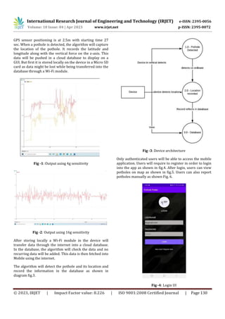
4. ARCHITECTURAL DESIGN
The device is based on Arduino which is connected with
sensors consisting of a 3-axis accelerometer ADXL345
used to detect a vertical force(pothole) using z-axis [5]and
keeping a note of device positioning using x-axis.
Accelerometer was tested at different sensitivities, using
at 4g and 8g no accuracy was obtained as shown in fig.1.
Using 16g in ADXL345 accuracy was observed as shown in
fig.2. A GPS module, Ublox NEO-6M GPS [6] is used to
record the location of the pothole.](https://image.slidesharecdn.com/irjet-v10i421-230610114715-2339e3d7/85/Pothole-Detection-using-IoT-Android-and-iOS-1-320.jpg)
![International Research Journal of Engineering and Technology (IRJET) e-ISSN: 2395-0056
Volume: 10 Issue: 04 | Apr 2023 www.irjet.net p-ISSN: 2395-0072
© 2023, IRJET | Impact Factor value: 8.226 | ISO 9001:2008 Certified Journal | Page 132
REFERENCES
[1] MumbaiMirror Article [Online] .Available :
https://mumbaimirror.indiatimes.com/mumbai/other
/photos-roads-full-of- potholes-across-mumbai- enrage-
commuters/articleshow/70460342.cms
[2] Artis Mednis, Girts Strazdins, Reinholds Zviedris,
Georgijs Kanonirs, Leo Selavo. (06 June 2014). Real Time
Pothole Detection using Android Smartphones with
Accelerometers.[Online] Available
https://www.researchgate.net/publication/22425315
4_Real_Time_Pothole_Detection_Using_Android_Smartpho
nes_with_Accelerometers
[3] X. Yu and E. Salari, “Pavement pothole detection and
severity measurement using laser imaging,” in
Proceedings of the IEEE International Conference on
Electro/Information Technology (EIT ’11), pp. 1–5,
Mankato, Minn, USA, May 2011.
[4] J. Lin and Y. Liu, “Potholes detection based on SVM in
the pavement distress image,” in Proceedings of the 9th
International Symposium on Distributed Computing and
Applications to Business, Engineering and Science
(DCABES ’10), pp. 544–547, Hong Kong, August 2010.
[5] Accelerometer, (1 March 2019) W3C Process
Document[Online].
Available :
https://www.w3.org/TR/accelerometer/#acceleromet er-
z
[6]GPS[Online]Available:https://www.electroschematics.c
om/neo-6m-gps- module/](https://image.slidesharecdn.com/irjet-v10i421-230610114715-2339e3d7/85/Pothole-Detection-using-IoT-Android-and-iOS-4-320.jpg)

1. The document describes a system to detect potholes using IoT devices with sensors like accelerometers and GPS, and report the location and sensor data to a cloud database. 2. A mobile app allows users to view reported pothole locations on a map and also manually report potholes. 3. The system aims to increase transparency around pothole conditions to help people and improve road safety. Future work could include detecting pothole depth for more accurate data.


![Final_Road_Classification_Pothole_Detection_PPT[1].pptx](https://cdn.slidesharecdn.com/ss_thumbnails/finalroadclassificationpotholedetectionppt1-260106175235-72ada4c8-thumbnail.jpg?width=640&height=640&fit=bounds)


