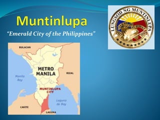
2. The City of Muntinlupa is the southernmost city in
Philippine National Capital Region. It is classified as a Highly
Urbanized City with a population of more than 400,000 and is
given the nickname "Emerald City of the Philippines" by the
tourism establishment.
Muntinlupa was once notoriously known as the
location of the national insular penitentiary, the New Bilibid
Prison, where the country's most dangerous criminals were
incarcerated. Consequently, Muntinlupa or "Munti" became
synonymous with the national penitentiary although it has
largely shaken-off this negative image to become one of the
most progressive cities in the country.
3. Muntinlupa is also home to some of the best
commercial establishments in the metropolis and is the
location of Ayala Alabang Village, one of the country's biggest
and most expensive residential communities, where many of
the wealthy and famous live.
Muntinlupa is also the first city in the Philippines to
ban the use of plastic bags and Styrofoam for packaging.
4. - 459,941 Total Population
- 9 Total barangays (District I and II)
-Total Land Area of 46.70 sq. kms. or 4,670 hectares.
- Muntinlupa lies within 14 degrees 23' longitude and
121 degrees 02' latitude.
- Located on the Southwestern Coast of Laguna de Bay.
- It is bounded on the:
North by Taguig;
Northwest by Parañaque;
West by Las Piñas;
Southwest by the Province of Cavite;
South by the Province of Laguna; and
East by Laguna de Bay
6. TOPOGRAPHY
Muntinlupa’s terrain is relatively flat to slopping
towards the east along the lake. Gentle rolling hills occupy
the western part of the city, with elevation increasing up to
60 meters and above towards its southwest portion.
CLIMATE
The PAG-ASA bases its classification of the types of
climate in the Philippines upon the types of rainfall. There are
four (4) types of rainfall, and four (4) corresponding types of
climate. Muntinlupa has the first type of rainfall and thus, the
first type of climate, which is characterized by two
pronounced seasons. The dry season rungs through the
months of November to April, while the wet season starts in
May and lasts to October. The wet season reaches its peak in
the month of August.
7. Rainfall Maximum rainfall in Muntinlupa usually occurs from
the month of June to September. The average annual of
rainfall is 1822.8 millimeters with a peak of 417.0 millimeters
in August and a low 3.6 millimeters in February.
Temperature The annual mean temperature reading for
Muntinlupa is 27.92. The highest temperature occurs during
the month of April and May (30o) while the lowest occurs
during the months of December, January & Friday (26o).
Humidity The relative humidity of Muntinlupa has an annual
average of 78%. This makes the municipality better than the
municipalities of Laguna, which has an average relative
humidity of 81%.
8. Wind Direction From October to May, prevailing winds blow
easterly at the rate of 9mph, while the rest of the months
have winds blowing westerly.
Typhoon The Philippines, due to its geographical location, is
one of the Asian countries often affected by typhoons. It is
located within the so-called “typhoon belt”. Generally,
typhoon season starts from June and ends in November.
However, the rest of the months are not entirely free of the
typhoons since they are unpredictable in nature and might
enter the country anytime of the year. The mean percentage
frequency of typhoon passage over the Metropolitan Manila,
of which Muntinlupa is a part, ranges from 11% to 20%.
9. HYDROGEOLOGIC FEATURES
Ground water development in the area is rated good which is
probably one reason why many of the residents obtain their
water by deep well.
The Marikina Faultline traverse Muntinlupa on a north-south
direction from Marikina to Taal Lake, entering through Sucat
and exiting towards Tunasan.
11. DEMOGRAPHIC PROFILE
Population Projection 2013 487,376
Population (2010 NSO-Census) 459,941
Annual Growth Rate 1.95%
Projected Population Density 2013
10,436
persons/sq.km.
Population Density (2010 NSO Census)
9,849
persons/sq.km.
Population Household (2010 NSO-Census) 438,843
Crude Birth Rate 13.23
Crude Death Rate 3.91
Infant Mortality Rate 7.80
Maternal Mortality Rate 0.64
12. SOCIAL PROFILE
Health
Leading Cause of Mortality
Myocardial
Infarction
Leading Cause of Morbidity Bronchitis
Leading Cause if Infant Mortality Pneumonia
Leading Cause of Maternal Death Eclampsia
13. Health Facilities
No. of Public Hospital 1
No. of Private Hospital 5
No. of Public Health Center 14
No. of Public Lying-In Center 1
No. of Public Reproduction Health Center 1
No. of City Water Laboratory 1
No. of Private Medical Clinic 40
No. of Private Dental Clinic 24
14. Water and Sanitation
No. of households with access to safe water supply 86,807
No. of households with Sanitary Toilet Facility 85,126
No. of households with sanitary garbage disposal
75% of
total
household
15. Education
No. of Public Elementary School 20
No. of Public High School 8
No. of Private School 96
No. of Public Tertiary School 1
No. of Private Tertiary School 26
17. ECONOMIC PROFILE
Total Number of Registered Business (2013)
Name of Barangay Total
Tunasan 1,176
Poblacion 723
Putatan 1,252
Bayanan 452
Alabang 4,994
Ayala Alabang 3,002
Cupang 736
Buli 129
Sucat 383
T O T A L 12,847
18. Major Shopping Malls
SM Supercenter
Alabang Town Center
Festival Supermall
Metropolis Starmall
Llanas Alabang Center Mall
South Station Market
30. Political Leaders
Mayor: Atty. Jaime R. Fresnedi
Vice-Mayor: Artemio A. Simundac
Congressman: Rodolfo G. Biazon
District I, Councilors
Atty. Raul R. Corro
Atty. Patricio L. Boncayao, Jr.
Bal Niefes
Stephanie G. Teves
Louisito A. Arciaga
Margarita Amythyst P. Labios, M.D.
Ringo A. Teves
Alexander B. Diaz
31. District II, Councilors
Robert A. Abas
Robert P. Baes
Ma. Dhesiree G. Arevalo
Luvi P. Constantino
Neptali S. Santiago
Elmer S. Espeleta
Rafael T. Sevilla
Vergel C. Ulanday
ABC Chairman: Celso Dioko
SK Chairman: Eulogio Dioko, II
The Muntinlupa City Government is composed of 1
congressional representative, 1 city mayor, 1 city vice mayor, 16
city councilors, 1 representative from the barangay sector and 1
representative from the youth sector.
32.
33. The City of Malabon is one of the cities and
municipalities that make up Metro Manila in the Philippines.
Located just north of Manila, the city has a population of
353,337 as of 2010. It is primarily a residential and industrial
town and is one of the most densely populated cities in the
metropolis. It has a total land area of 19.714 square
kilometers.
Malabon is part of the sub-region of Metro Manila
informally called CAMANAVA, which consists
of CAloocan, MAlabon, Navotas, and VAlenzuela cities.
Caloocan lies to the south and east, Navotas to the west, and
Valenzuela to the north. Malabon also borders the town of
Obando in the province of Bulacan to the northwest.
34. History
Malabon, per legend, came from the words maraming
labong which means "plenty of labong", the edible bamboo
shoots. Originally called the town of Tambobong, Malabon
was founded as a “Visita” of Tondo by the Augustinian friars
on May 21, 1599 and remained under the administrative
jurisdiction of the province of Tondo from 1627 to 1688.
The newspaper La Independencia was first printed in
Malabon’s Asilo de Huérfanos, where orphaned children due
to a plague in 1882 were housed.
35. Malabon was officially made a municipality of the
newly created province of Rizal on June 11, 1901 by virtue of
Philippine Commission Act No. 137. When Act No. 942 was
promulgated, Malabon was merged with Navotas under a
new government. On January 16, 1906, Act No. 1441
separated Malabon from Navotas into two distinct
municipalities of the Rizal province. The first Mayor of
Malabon was Vicente Villongco.
For 70 years, Malabon was a municipality of Rizal, until
November 7, 1975, by virtue of Presidential Decree No. 824,
when Malabon became a part of Metropolitan Manila or
the National Capital Region. Malabon became a city on April
21, 2001, under Republic Act No. 9019 when Malabon was
407 years old.
36. Former Mayor Tito Oreta, who died in office in 2012,
was credited with building some of Malabon's most
important modern infrastructure projects, including the new
eleven-story Malabon City Hall, the Oreta Sports Complex
Building and a Government Center Annex.
37. Malabon City is now divided into 21 barangays.
District I
Baritan
Bayan-bayanan
Catmon
Concepcion
Dampalit
Flores
Hulong-Duhat
Ibaba
Maysilo
Muzon
Niugan
Panghulo
San Agustin
Santolan
Tañong
District II
Acacia
Longos
Potrero
Tinajeros
Tonsuya
Tugatog
38.
39. Topography, Slope and Physiology
Generally flat topography, with slope ranging from 0 to 5%
Eastern portion of Malabon lies at the Guadalupe Plateau.
Land use
Use Hectares
Residential 597.29
Commercial 305.64
Industrial 516.99
Agricultural/Fishpond 20.00
Open Space 14.62
Cemetery 17.67
54. Marikina is one of the cities that make up Metro
Manila, the National Capital Region. Marikina shortly became
a former capital of the Province of Manila during the
declaration of Philippine Independence from 1898 to 1899.
Marikina was given the title Shoe Capital of the
Philippines because of its notable shoe industry, being the
biggest manufacturer of shoes in the Philippines, producing
almost 70% of shoe production in the country. The Shoe
Museum houses part of the famous shoe collection of the
former First Lady Imelda Marcos, shoes of some of the world
leaders and celebrities and shoes of different countries,
making it the world's largest collection of pair of shoes in a
museum.
55. Marikina is the main gateway of Metro Manila to Rizal
Province as well as Quezon Province. It is one of the most
awarded metropolitan city in the Philippines, including the
prestigious "Most Competitive Cities in the Philippines"
awarded by National Competitiveness Council in 2003 and
2005,] and until now, Marikina maintains on top 10 list in
Philippine rankings, and ranking number 1 in Metro Manila
for many years.[The city is rapidly transformed into a highly
urbanized and one of the wealthiest local government unit in
the Philippines. It is also home of some of high-end
communities in Metro Manila, such as Loyola Grand Villas,
Provident Villages and gated communities in Barangay
Industrial Valley and Marikina Heights where many of the
wealthy and famous live.
56. Geography
Land area
The total land area of Marikina is approximately 21.5 square
kilometers (km²) or 2,150 hectares (ha). This represents about
3.42% of the total land area of Metro Manila. At present, the
city is composed of 16 barangays. Barangay Forture,
Concepcion Dos and Marikina Heights are among the largest
barangays in terms of land area.
Land use
The south portion of the city occupies the numerous
commercial, industrial and residential areas, heritage sites
and mixed use zones, while the north and northeast portion
are primarily for residential and industrial zones, and various
establishments such as small and medium enterprises.
57. Loyola Grand Villas, located at the northwest portion
of the city is a rich gated community that occupies upper-
middle class and rich residential areas. Barangay Sta. Elena
represents as poblacion or the center of Marikina. At present,
it comprises 38% residential, 19% commercial and industrial,
17% Roads, 8% Mixed-use, 18% for parks and open spaces,
development areas, institutional, cemeteries and others.
58. Boundaries
From north, Marikina occupies most of the south bank of
Nangka River. The east slices at the foot end of Sierra Madre
mountains of Antipolo and sliced by the streets of Montserrat
Hill, Bonanza and Starlite in Barangay Concepcion Dos. The
southeast slices by Sapang Baho River occupies the north-west
bank. The south portion sliced by Marcos Highway and occupies
most of the north side of the highway and extends to the west
until it occupies the LRT-2 Santolan Station depot until it
reaches the Marikina River. The east occupies the southernmost
of Quezon City hills which lies Barangay Industrial Valley and
sliced by C5 Road occupies the west side until it reaches Ateneo
de Manila University campus. The east part of the campus
covers the city extends up to the north and sliced by several
roads of Loyola Grand Villas which covers the east part of the
village until it reaches Marikina River and its tributary Nangka
River to the north.
59. Climate
Marikina features a tropical monsoon climate. Its proximity to
the equator means that the temperature range is very small,
rarely going lower than 18 °C (64 °F) and going higher than
38 °C (100 °F). However, humidity levels are usually very high
which makes it feel much warmer, especially the city lies in
the valley. It has a distinct, relatively short dry season from
January through May, and a relatively lengthy wet season
from June up to December.
60. Local government
Like in other city governments in the Philippines,
Marikina is governed by a mayor and a vice mayor elected to
three-year terms. The mayor is the executive head and leads
the city's departments in executing the city ordinances and
improving public services along with city councilors while the
vice mayor heads a legislative council along with barangay
councilors. Every barangay also has its own set of projects,
providing community service in the city as well as basic
services provided for remote residences.
Marikina was awarded numerous times in good
governance, management and integrity. Marikina boasts one
of the wealthiest local governments in the Philippines.
61. Legislative districts
Marikina is divided into 2 districts, Districts 1 and 2, where
each district is represented by a congressman in the House of
Representatives of the Philippines.
District 1
Barangka
Calumpang
Industrial Valley
Jesus Dela Peña
San Roque
Santa Elena
Santo Niño
Tañong
District 2
Concepcion Uno
Concepcion Dos
Fortune
Malanday
Marikina Heights
Nangka
Parang
Tumana
74. CITY MAYOR: De Guzman, Del Reyes
CITY VICE-MAYOR: Cadiz, Jose Fabian Imperial
District I, Councilors
Ferriol, Samuel Santos
Paz, Eva Aguirre
Banzon, Joseph Bernabe
Ayuson, Frankie Cruz
Santos, Thaddeus Antonio Jr. Manuel
De Leon, Mario Mariano
Acuña, Ronnie Santos
Chavez, Willie Nicolas
75. District II, Councilors
Reyes, Ruben Rodriguez
Diazen, Xyza Rafsing
Dayao, Paul Del Barrio
Flores, Ernesto Mateo
Del Rosario, Mark Albert Javier
Cuaresma, Ariel Vicente
Magtubo, Susana Pinongcos
Ortiz, Rommel Fuentes
76.
77. The City of Mandaluyong is Located at the approximate
geographical centre of Metro Manila, it is bordered on the
west by the country's capital, Manila, to the north by San Juan
City, to the east by Quezon City and Pasig City, and by Makati
City to the south. The city is known for being the Tiger City of
the Philippines and the Shopping Capital of the Philippines.
Among the many attractions in the city is the western
half of the Ortigas Center, one of the major centers of business
and commerce in the metropolis (the eastern half is in Pasig
City). Found within the Mandaluyong portion of the Ortigas
Center is the main headquarters of the Asian Development
Bank, Banco De Oro, and the headquarters of San Miguel
Corporation, Southeast Asia's largest food and beverage
company. One of the most prominent pharmaceutical
laboratories and factories, Unilab, is located here.
78. History
Mandaluyong formed part of what was once the Kingdom of
Sapa of the Great Majapahit Empire around 1300. More than
a century later, around 1470, it expanded and was called the
Kingdom of Namayan. The vast kingdom comprised what are
now Quiapo, San Miguel, Sta.
Mesa, Paco, Pandacan, Malate and Sta. Ana in Manila, and
Mandaluyong, San
Juan, Makati, Pasay, Pateros, Taguig,Parañaque, and portions
of Pasig and Quezon City up to Diliman.
Mandaluyong was first known as a barrio of Sta. Ana de Sapa
which was part of the District of Paco, Province of Tondo.
NamedSan Felipe Neri by the Spaniards in honour of the
patron saint of Rome, it was separated from Sta. Ana de Sapa
in 1841.
81. District Barangays Land Area
(has)
Population
(2007)
Population
(2010)
2 Namayan 30.60 4,846 5,706
1 New Zañiga 21.96 5,413 6,354
2 Old Zañiga 42.48 6,674 7,712
1 Pag-Asa 12.60 3,112 3,688
2 Plainview 115.92 24,706 24,396
1 Pleasant Hills 20.33 6,495 5,648
1 Poblacion 24.12 14,778 15,191
2 San José 3.18 7,629 7,041
2 Vergara 15.12 4,928 4,645
1
Wack-Wack
Greenhills
294.48 6,126 7,889
82. Economy
Mandaluyong is deemed as the "Tiger City" because of
its vibrant business and economic activity. The city is home to
a number of shopping centers, entertainment hubs,
commercial establishments, high-rise offices, residential
condominiums and hotels. The city is now one of the most
important business and financial areas in the metropolis.
83. Commercial activities
Like other cities in Metro Manila, Mandaluyong has its
own share of commercial strips and a central business district.
The former commercial area, consisting mostly of banks,
offices and service establishments, stretch along public
transport routes thereby serving both local consumers and
passers-by from the neighboring localities. Major commercial
strips of the city include the stretch of Boni Avenue,Shaw
Boulevard, Libertad-Sierra Madre area, Kalentong, San
Francisco, part of Martinez, Sgt. Bumatay towards Barangka
Drive and Pinatubo towards EDSA. Mandaluyong's central
business district is concentrated on the EDSA-Shaw-Pioneer
area.
84. Industrial activities
Industrial activities are mostly concentrated within
the Shaw Boulevard-Pioneer area and along the Pasig River.
Although prominent in the manufacture of foods, medicines
and laboratory equipment, these industries are gradually
declining in number, opting to relocate in newly developed
industrial zones outside Metropolitan Manila. In the Pasig
River area, particularly in Barangays Namayan and Mabini J.
Rizal, areas formerly industrial are now the sites for
residential subdivisions and townhouses. In the EDSA-Shaw-
Pioneer area, the transformation is toward a more
economically profitable and globally competitive commercial
activity.
86. Factories and industries
Dave Vergel B. Castro & Associates
Eggsakto Foods
Crafts and Passions
Buffalo Piping Systems
Fit N' Fab Water Systems
Hewlett-Packard Philippines
Summit Media
Commonwealth Foods, Inc.
United Laboratories (UNILAB)
Solar Entertainment Corporation
Solar Television Network
San Miguel Corporation
Puma Spring and Rubber Industries
Accenture Philippine Delivery Center
J.O. Maningas & Associates
99. Elected Officials
City Mayor: Benjamin D.C. Abalos Jr.
City Vice Mayor: Edward G. Bartolome
District 1, councilors
Charisse Abalos
Antonio D. Suva
Ayla V. Alim
Luisito E. Espinosa
Grace Antonio
Alex I. Santos
District 2, Councilors
Cherry Lynn Pablo-Santos
Fernando S. Ocampo
Rodehl B. Bacar
Jesus C.Cruz
Alexander C. Sta. Maria
Francisco O. Esteban
100. “The Premier Gateway to the Philippines”
“The Travel Capital of The Philippines”
101. Pasay City is bordered on the north by the country's
capital, the City of Manila, to the northeast by Makati City, to
the east by Taguig City, and Parañaque City to the south.
Pasay City was one of the original four cities of Metro Manila.
Due to its proximity to Manila, it quickly became an urban
town during theAmerican Occupation.
102. History
In 1727, the ancient pre colonial name of the Pasay
settlement was changed to Pineda in honor of Don Cornelio
Pineda, a Spanish horticulturist, who requested for guardias
civiles for protection from indigenous rebellion. The name
Pineda, along with Pasay, was used as the name of the place
until the early 20th century.
On May 21, 2006, SM Mall of Asia was opened in Bay City as
then the 2nd largest mall in the Philippines.
103. Geography
Pasay City covers a total land area of 18.50 square
kilometres (7.14 sq mi), making it the third smallest political
subdivision in the National Capital Region. It borders City of
Manila to the north, Parañaque to the south, Makati and
Taguig to the northeast, and Manila Bay to the west.
The city can be divided in 3 distinct areas: the city's urban
area with an area of 5.505 square kilometres (2.125 sq mi);
the Civil Aeronautics Administration (CAA) complex, which
include the Ninoy Aquino International Airport (NAIA) and
the Villamor Airbase, with an area of 9.5 square kilometres
(3.7 sq mi); and the reclaimed land from Manila Bay with an
area of 4.00 square kilometres (1.54 sq mi).
104. Pasay is composed of seven (7) districts, subdivided
into twenty (20) zones, with a total of 201 barangays. The
barangays don't have names but are only designated with
sequential numbers. The largest zone with an area of 5.10
square kilometres (1.97 sq mi) is Zone 19, which covers
barangays 178 and 191. The smallest zone with an area of 10
hectares (25 acres) is Zone 1, covering Barangays 1 to 3 and
14 to 17.