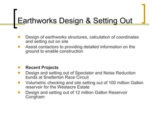
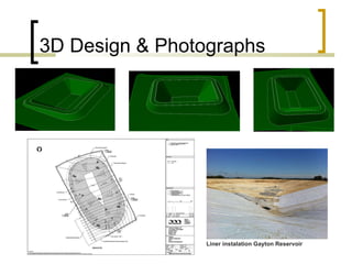
Plandescil – Surveying “ Land surveying is the technique and science of accurately determining  the terrestrial or three-dimensional position of points and the distances and angles between them”
Surveying Instruments Topcon Total Station EDM – GPT 7005 Class II Laser for Prism and reflectorless measurement On board computer processing and software for recording & setting out data Angular recording to 5 seconds (0.00138 degrees) General distance measurement accuracies. +/- 5mm in 1000m Multiple point recording and average of coordinate easting, northing and level in 1.2 seconds.  Waterproofing to IP54  Recording of approximately 1000 points per working day.
Surveying Instruments Topcon GRS-1 GPS RTK  1cm accuracy to Ordnance Survey grid coordinates and level.  Dual constellation receiver GPS + & GLONASS commonly 12 to 18 satellites providing surveying position.  In built camera Connection to the Internet via in built modem in the field.  Light weight and durable and waterproof, no calibration required.  Limitations due to phone network coverage and overhead obstructions Recording of approximately 1600 points per working day.
Topographical Surveying Recording and presentation of land features and structures Production of enhanced colour drawings using AutoCAD drafting software Diverse range of clients and sites leads us to some challenging and interesting projects.  Recent Projects Colney Memorial Burial Park – Survey of 6500 trees and development of Burial Plan  Dereham Town Centre regeneration  Oxnead Hall – Built 1580 - Host to King Charles II and Court
Topographical Survey – Oxnead Hall
Site Photographs Oxnead Hall  Oxnead Hall Colney Memorial Park  Oxnead Hall
Earthworks Design & Setting Out Design of earthworks structures, calculation of coordinates and setting out on site  Assist contactors to providing detailed information on the ground to enable construction Recent Projects Design and setting out of Spectator and Noise Reduction bunds at Snetterton Race Circuit Volumetric checking and site setting out of 100 million Gallon reservoir for the Westacre Estate Design and setting out of 12 million Gallon Reservoir Congham
3D Design & Photographs Liner instalation Gayton Reservoir
Structural Setting Out Precision setting out of house corners and plots to approved Planning Permission Pile setting out Structural steel grid lines and column positions for the erection of steel framed buildings.  Precise boundary setting out Recent Projects Placement of elevator pits to Ster Century Cinema Castle Mall Norwich Pile setting out Sutton Bridge Power Station Residential Development of 360 Houses with Roads and Infrastructure at Mulbarton.
Building Elevations & Internal Surveys Laser measurement of complex building elevations used as basis for Architectural design.  Internal building surveys as basis for Architectural design or Asset Management.  Recent Projects  Blakeney Hotel – Building remodeling and extensions Pages Place Watton – Building refurbishment
Drawings and Photographs – Blakeney Hotel
Boundary Disputes & Conveyancing   GPS survey of boundary features, comparison to Land Registry Title Plans and Ordnance Survey mapping.  Compilation of evidence in support of Boundary Disputes Expert legal witness  Production of Land Registry compliant Estate and land purchase plans Recent Projects Surveyor and expert witness to support client against Norfolk County Council for rights of Public Footpath access.
Expert Witness Statement Document
Conclusion Demonstration of the advances in technology for modern Surveying.  A Land Surveyor’s role in Construction Engineering Thank you  Carl Jenkins MCInstCES, TMICE, Eng. Tech

Plandescil – Surveying

  • 1.
    Plandescil – Surveying“ Land surveying is the technique and science of accurately determining the terrestrial or three-dimensional position of points and the distances and angles between them”
  • 2.
    Surveying Instruments TopconTotal Station EDM – GPT 7005 Class II Laser for Prism and reflectorless measurement On board computer processing and software for recording & setting out data Angular recording to 5 seconds (0.00138 degrees) General distance measurement accuracies. +/- 5mm in 1000m Multiple point recording and average of coordinate easting, northing and level in 1.2 seconds. Waterproofing to IP54 Recording of approximately 1000 points per working day.
  • 3.
    Surveying Instruments TopconGRS-1 GPS RTK 1cm accuracy to Ordnance Survey grid coordinates and level. Dual constellation receiver GPS + & GLONASS commonly 12 to 18 satellites providing surveying position. In built camera Connection to the Internet via in built modem in the field. Light weight and durable and waterproof, no calibration required. Limitations due to phone network coverage and overhead obstructions Recording of approximately 1600 points per working day.
  • 4.
    Topographical Surveying Recordingand presentation of land features and structures Production of enhanced colour drawings using AutoCAD drafting software Diverse range of clients and sites leads us to some challenging and interesting projects. Recent Projects Colney Memorial Burial Park – Survey of 6500 trees and development of Burial Plan Dereham Town Centre regeneration Oxnead Hall – Built 1580 - Host to King Charles II and Court
  • 5.
  • 6.
    Site Photographs OxneadHall Oxnead Hall Colney Memorial Park Oxnead Hall
  • 7.
    Earthworks Design &Setting Out Design of earthworks structures, calculation of coordinates and setting out on site Assist contactors to providing detailed information on the ground to enable construction Recent Projects Design and setting out of Spectator and Noise Reduction bunds at Snetterton Race Circuit Volumetric checking and site setting out of 100 million Gallon reservoir for the Westacre Estate Design and setting out of 12 million Gallon Reservoir Congham
  • 8.
    3D Design &Photographs Liner instalation Gayton Reservoir
  • 9.
    Structural Setting OutPrecision setting out of house corners and plots to approved Planning Permission Pile setting out Structural steel grid lines and column positions for the erection of steel framed buildings. Precise boundary setting out Recent Projects Placement of elevator pits to Ster Century Cinema Castle Mall Norwich Pile setting out Sutton Bridge Power Station Residential Development of 360 Houses with Roads and Infrastructure at Mulbarton.
  • 10.
    Building Elevations &Internal Surveys Laser measurement of complex building elevations used as basis for Architectural design. Internal building surveys as basis for Architectural design or Asset Management. Recent Projects Blakeney Hotel – Building remodeling and extensions Pages Place Watton – Building refurbishment
  • 11.
    Drawings and Photographs– Blakeney Hotel
  • 12.
    Boundary Disputes &Conveyancing GPS survey of boundary features, comparison to Land Registry Title Plans and Ordnance Survey mapping. Compilation of evidence in support of Boundary Disputes Expert legal witness Production of Land Registry compliant Estate and land purchase plans Recent Projects Surveyor and expert witness to support client against Norfolk County Council for rights of Public Footpath access.
  • 13.
  • 14.
    Conclusion Demonstration ofthe advances in technology for modern Surveying. A Land Surveyor’s role in Construction Engineering Thank you Carl Jenkins MCInstCES, TMICE, Eng. Tech