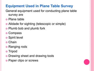
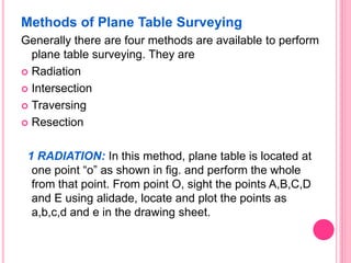
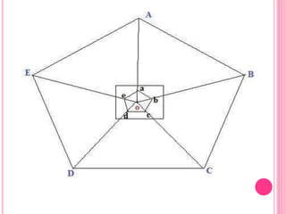
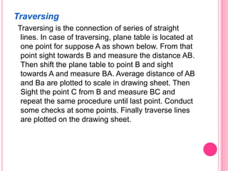
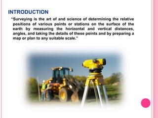
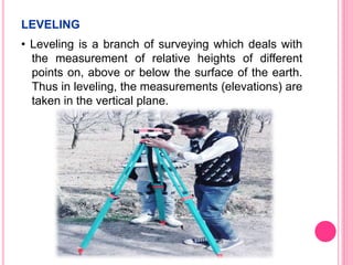
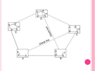
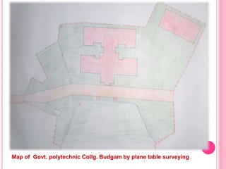
This document describes an extensive survey project submitted by a group of civil engineering students at a government polytechnic college in Budgam. It includes an acknowledgement section, list of group members, and sections on the introduction, objectives, types of leveling, plane table surveying, intersection method, traversing method, compass surveying, and types of magnetic compasses used including the prismatic compass. The project involves leveling, plane table surveying and compass surveying methods.
Helps for new studens fresher.
Students from civil engineering department are participated in the camp
.the camp was held at chandwaji temple ,Delhi highway,jaipur The camp organized for a period of 3rd days (16 sep. 2018 to 18 sep. 2018)
SUBMITTED BY
1,SUMIT YADAV
2 ANOOP BANSHIWAL
MOBILE
8741828148 : Anoop
Plane Table Surveying is a graphical method of survey in which the field observations and plotting are done simultaneously.
It is simple and cheaper than theodolite survey. It is most suitable for small scale maps.
The plan is drawn by the surveyor in the field, while the area to be surveyed is before his eyes. Therefore, there is no possibility of omitting the necessary measurements.
In Compass survey chain or tape is used for linear measurements and compass is used for fixing direction.
In compass freely suspended magnetic needle directs to north- south and the bearing of line is obtained by line of sight.
When large area are involved, compass surveying is used.
There are mainly two methods of land measurement.
Triangulation survey
Traverse survey
DEFINATION :-
The art of determining the relative heights of different points on , below or above the surface of the earth
Deals with measurement in – vertical plane
Aim – to determine relative height of different points - on , below or above the surface of the earth , to find undulation of the ground
Definition of Surveying
Objects of Surveying
Uses of Surveying
Primary Divisions of Surveying
Principles of Surveying
List of Classification of Surveying
Definitions : Plan and Map, scales :Plain Scale and Diagonal Scale,
Upon completing the course, the students will be able to:
1. Define and state the scope of surveying and geomatics in civil engineering
2. Understand the basic principles of surveying and geomatics engineering
3. Apply the different methods of surveying and geomatics to measure the features of interest
4. Analyze the traditional and advanced methods of surveying
5. Evaluate the different techniques of surveying and geomatics in solving real world problems.
6. Design and construct solutions for real world problems related to surveying and geomatics.
Surveying Engineering
Contour & Contouring
In this lecture we will cover
definitions.
Characteristics of contour lines.
Contours used by Engineers .
Methods of locating contour.
Method of Interpolation Contours.
Contour & Contouring
A map showing the natural and cultural features as well
as showing the nature of the surface of the land (topography of the
land) of the up and downs and its representation in (3D)three
dimensions.
A contour is a line drawn on a plan joining all points of the same
height above or below a datum.
Or A contour line
is a line that passes through points having the same elevation.
contour interval
is the constant vertical distance(VD) between any two
consecutive contours is called the contour interval
. The contour interval on this map is 20m
-The choice of suitable contour interval depends on several
factors.
-Topographic Maps
-Characteristics of contour lines.
-Contours are used by Engineers to:
-Methods of locating contour:
A- The direct methods
1- Level and staff method.
2- Plan table and alidade method.
Direct method procedure:
In this method the actual contour is pegged out on the ground and its
planimetric position located. A back-sight is taken to an appropriate BM and
the HPC of the instrument is obtained, say( 34.800m.) A staff reading of
0.800m would then place the foot of the staff at the( 34m )contour level. The
staff is then moved throughout the terrain area, with its position pegged at
every 0.800m reading. In this way the 34m contour is located. Similarly a
staff reading of (1.800m) gives the 33m contour and so on. The planimetric position of the contour needs to be located using an appropriate survey technique.
1- Grid method:-
Methods of Contouring
B- Indirect contouring
*Method of Interpolation Contours.
-Plotting contours.
Prepared by:
Asst. Prof. Salar K.Hussein
Mr. Kamal Y.Abdullah
Asst.Lecturer. Dilveen H. Omar
Erbil Polytechnic University
Technical Engineering College
Civil Engineering Department
Introduction of surveying_Surveying, Civil EngineeringA Makwana
Surveying is the art of determining the relative positions of points on, above or beneath the surface of the earth.
The relative positions are determined by measuring horizontal distances, vertical distances, horizontal angles and vertical angles accurately using various surveying instruments.
Levelling is a branch of surveying dealing with determination of relative heights of the point on the surface of the earth in a vertical plane.
Sachpazis:Terzaghi Bearing Capacity Estimation in simple terms with Calculati...Dr.Costas Sachpazis
Terzaghi's soil bearing capacity theory, developed by Karl Terzaghi, is a fundamental principle in geotechnical engineering used to determine the bearing capacity of shallow foundations. This theory provides a method to calculate the ultimate bearing capacity of soil, which is the maximum load per unit area that the soil can support without undergoing shear failure. The Calculation HTML Code included.
Explore the innovative world of trenchless pipe repair with our comprehensive guide, "The Benefits and Techniques of Trenchless Pipe Repair." This document delves into the modern methods of repairing underground pipes without the need for extensive excavation, highlighting the numerous advantages and the latest techniques used in the industry.
Learn about the cost savings, reduced environmental impact, and minimal disruption associated with trenchless technology. Discover detailed explanations of popular techniques such as pipe bursting, cured-in-place pipe (CIPP) lining, and directional drilling. Understand how these methods can be applied to various types of infrastructure, from residential plumbing to large-scale municipal systems.
Ideal for homeowners, contractors, engineers, and anyone interested in modern plumbing solutions, this guide provides valuable insights into why trenchless pipe repair is becoming the preferred choice for pipe rehabilitation. Stay informed about the latest advancements and best practices in the field.
About
Indigenized remote control interface card suitable for MAFI system CCR equipment. Compatible for IDM8000 CCR. Backplane mounted serial and TCP/Ethernet communication module for CCR remote access. IDM 8000 CCR remote control on serial and TCP protocol.
• Remote control: Parallel or serial interface.
• Compatible with MAFI CCR system.
• Compatible with IDM8000 CCR.
• Compatible with Backplane mount serial communication.
• Compatible with commercial and Defence aviation CCR system.
• Remote control system for accessing CCR and allied system over serial or TCP.
• Indigenized local Support/presence in India.
• Easy in configuration using DIP switches.
Technical Specifications
Indigenized remote control interface card suitable for MAFI system CCR equipment. Compatible for IDM8000 CCR. Backplane mounted serial and TCP/Ethernet communication module for CCR remote access. IDM 8000 CCR remote control on serial and TCP protocol.
Key Features
Indigenized remote control interface card suitable for MAFI system CCR equipment. Compatible for IDM8000 CCR. Backplane mounted serial and TCP/Ethernet communication module for CCR remote access. IDM 8000 CCR remote control on serial and TCP protocol.
• Remote control: Parallel or serial interface
• Compatible with MAFI CCR system
• Copatiable with IDM8000 CCR
• Compatible with Backplane mount serial communication.
• Compatible with commercial and Defence aviation CCR system.
• Remote control system for accessing CCR and allied system over serial or TCP.
• Indigenized local Support/presence in India.
Application
• Remote control: Parallel or serial interface.
• Compatible with MAFI CCR system.
• Compatible with IDM8000 CCR.
• Compatible with Backplane mount serial communication.
• Compatible with commercial and Defence aviation CCR system.
• Remote control system for accessing CCR and allied system over serial or TCP.
• Indigenized local Support/presence in India.
• Easy in configuration using DIP switches.
1. EXTENSIVE SURVEY PROJECT
Submitted in partial fulfilment of the requirement for
major project at
COLLEGE CAMPUS
SUBMITTED BY
GROUP NO. 1
Civil engineering department
GOVERNMENT POLYTECHNIC COLLEGE
BUDGAM
2. Acknowledgement
We would like to express our sincere gratitude to
our project guides for giving us the opportunity
to work on this project. It would never be possible
for us to take this project to this level without
their innovative ideas and there relentless
support and encouragement
Project guides:
1) Er. Umer salam
2) Er. Tahseen
3. Name of Group1 students
1)Suhaib ul hassan 2) Taliba farooq
3) shahid nazir paray 4) danish ahmad
5)Mukhtar ahmad 6) sumiya altaf
7) ziya ul haq 8)wani shahid
9)Rayees ahmad dar 10)Mohd asif bhat
11)Bashrat nazir 12)Iqra
4. INTRODUCTION
“Surveying is the art of and science of determining the relative
positions of various points or stations on the surface of the
earth by measuring the horizontal and vertical distances,
angles, and taking the details of these points and by preparing a
map or plan to any suitable scale.”
5. OBJECTIVE OF SURVEYING
The object of surveying is to prepare a map or plan to show
the relative positions of the objects on the surface of the earth.
The map or plan is drawn to some suitable scale. It also
shows boundaries of districts, states, and countries too. It also
includes details of different engineering features such as
buildings, roads, railways, dams, canals etc.
To prepare a topographical map which shows hills, valleys,
rivers, forests, villages, towns etc.
To prepare a cadastral map which shows the boundaries of
fields, plots, houses and other properties..
To prepare an engineering map which shows the position of
engineering works such as buildings, roads, railways, dams,
canals.
6. LEVELING
• Leveling is a branch of surveying which deals with
the measurement of relative heights of different
points on, above or below the surface of the earth.
Thus in leveling, the measurements (elevations) are
taken in the vertical plane.
7. TYPES OF LEVELLING
The following are the different types of levelling
Simple levelling
Differential levelling
Fly levelling
Profile levelling
Cross sectioning and
Reciprocal levelling.
8. Simple Levelling
It is the method used for finding difference between the
levels of two nearby points
9. Differential Levelling
If the distance between two points A and B is large,
it may not be possible to take the readings on A and
B from a single setting.
In such situation differential levelling is used. In
differential levelling the instrument is set at more
than one position, each shifting facilitated by a
change point.
10. Plane table surveying
The plane table surveying is the fast method of
surveying. In this type of surveying plotting of the plan
and field observations can be done simultaneously. In
case of plane table surveying Geometrical conditions
of site are manuscript in the map sheet using plane
table and alidade after that topographic details are
arranged on the map.
11. Equipment Used in Plane Table Survey
General equipment used for conducting plane table
survey are
Plane table
Alidade for sighting (telescopic or simple)
Plumb bob and plumb fork
Compass
Spirit level
Chain
Ranging rods
Tripod
Drawing sheet and drawing tools
Paper clips or screws
12. Methods of Plane Table Surveying
Generally there are four methods are available to perform
plane table surveying. They are
Radiation
Intersection
Traversing
Resection
1 RADIATION: In this method, plane table is located at
one point “o” as shown in fig. and perform the whole
from that point. From point O, sight the points A,B,C,D
and E using alidade, locate and plot the points as
a,b,c,d and e in the drawing sheet.
13.
14. Intersection
In this method we can locate the point by plotting
two rays from two known stations. As shown in
figure, P and Q are the known station. First the
equipment is placed on P and plot the lines by
sighting the stations A, B and Q. then shift the
equipment to station Q and plot the lines by sighting
stations A, B and P. Finally, the intersection of A and
B rays is the required location of point of
intersection.
15. Traversing
Traversing is the connection of series of straight
lines. In case of traversing, plane table is located at
one point for suppose A as shown below. From that
point sight towards B and measure the distance AB.
Then shift the plane table to point B and sight
towards A and measure BA. Average distance of AB
and Ba are plotted to scale in drawing sheet. Then
Sight the point C from B and measure BC and
repeat the same procedure until last point. Conduct
some checks at some points. Finally traverse lines
are plotted on the drawing sheet.
16.
17. Map of Govt. polytechnic Collg. Budgam by plane table surveying
18. Compass surveying
Compass surveying is the branch of surveying in
which the position of an object is located using angular
measurements determined by a compass and linear
measurements using a chain or tape. Compass
surveying is used in following circumstances:
If the surveying area is large, chain surveying is not
adopted for surveying rather compass surveying is
employed.
If the plot for surveying has numerous obstacles and
undulations which prevents chaining.
If there is a time limit for surveying, compass
surveying is usually adopted
19. Magnetic compass
Magnetic compass is used to find out the magnetic
bearing of survey lines. The bearings may either
measured in Whole Circle Bearing (W.C.B) system
or in Quadrantal Bearing (Q.B) system based on
the type of compass used. The basic principle of
magnetic compass is if a strip of steel or iron is
magnetized and pivoted exactly at centre so that it
can swing freely, then it will establish itself in the
magnetic meridian at the place of arrangement.
Major types of magnetic compass are:
Prismatic compass
Surveyor’s compass
Level compass
20. Prismatic compass
Prismatic compass is a portable magnetic compass
which can be either used as a hand instrument or can
be fitted on a tripod. It contains a prism which is used
for accurate measurement of readings. The greatest
advantage of this compass is both sighting and
reading can be done simultaneously without changing
the position.