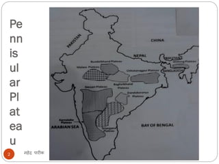
CLASS IX
SUBJECT – S.SC. (GEOGRAPHY)
PRESENTED BY – MAHENDRA KUMAR
महेंद्र पारीक1
PHYSICAL FEATURES OF INDIA
Pe
nn
is
ul
ar
Pl
at
ea
u
महेंद्र पारीक2
महेंद्र पारीक3
Pennisular Plateau
महेंद्र पारीक4
 The Peninsular plateau is a tableland
 composed of the old crystalline, igneous and
metamorphic rocks.
 Being part of Gondwana land make it the oldest
landmass.
 The plateau has broad and shallow valleys and
rounded hills.
 This plateau consists of two broad divisions, namely,
the Central Highlands and the Deccan
Plateau.
The Central
Highland
The Deccan
Plateau
महेंद्र पारीक5
Malwa Plateau
Bundelkhand
Baghelkhand
Chotanagpur
Plateau
DeccanTrap
Western Ghats
Eastern Ghats
North-East
Extension
PENNINSULAR PLATEAU- Central highland
महेंद्र पारीक6
 Malwa Plateau
Lies to the north of the Narmada river between
Aravali in North &Vindhya range in south
 Bundelkhand AND Baghelkhand
The eastward extensions of this plateau are locally
known as the Bundelkhand and Baghelkhand.
 The Chotanagpur plateau
 The Chotanagpur plateau marks the further
eastward extension, drained by the Damodar
river.
महेंद्र पारीक7
PENNINSULAR PLATEAU- Deccan Plateau
महेंद्र पारीक8
 DeccanTrap
 Largest plateau in India; Lies to the south of the
Narmada River; Shaped as inverted triangle.
 Surrounded by Satpura hills, Mahadeo hills, Maikala
range,Amarkantak hills and Rajmahal hills i the north;
Western Ghats in the west and the Eastern Ghats in the
east
 An extension of the Plateau is also visible in the northeast,
locally known as the Meghalaya, Karbi-Anglong Plateau and
North Cachar Hills
महेंद्र पारीक9
 Western Ghats (Shayadri)
 Folded parts of Deccan Plateau
 Continuous & higher than Eastern
Ghats caused orographic rains
 Separated from coast by narrow
coastal plains
 rivers like Godavari & Krishna
originates
 Extends fromTapi in North to
Kanyakumari in south
 Thalghat → Mumbai —- Kolkata
 Bhorghat → Mumbai —- Chennai
 Phalghat → Kochi ——– Chennai
 Nilgiri Range (Highestpeak → Doda
Betta along ooty →TN
 Highest Peak of South
India → Anaimudi From which 3
ranges radiates in 3 directions - 1
Cardmom Hills to south, 2 Anamalai
hills to north 3 Palni to North East
 Eastern Ghats
 Extends from Odisha to
North of Nilgiri hills
 Discontinuous & lower then
Western Ghats
 no important rivers
originates like western ghats
 Separated from coast by very
wide coastal plains
 Geologically older than
western ghats
 Mahanadi, Godavari,
Krishna, Kaveri cut through
this range to merge with Bay
of Bengal
 TheWestern Ghats and the
Eastern Ghats meet in the
Nilgiri hills
VOTE OF THANKS
महेंद्र पारीक10
ALMIGHTY GOD
NCERT
INTERNET
ENCYCLOPECIA BRITANNICA
OUR PRINCIPAL
VN PERCEPTIONS
MYVIEWERS

Physical Features of India 3 plateau

  • 1.
    CLASS IX SUBJECT –S.SC. (GEOGRAPHY) PRESENTED BY – MAHENDRA KUMAR महेंद्र पारीक1 PHYSICAL FEATURES OF INDIA
  • 2.
  • 3.
  • 4.
    Pennisular Plateau महेंद्र पारीक4 The Peninsular plateau is a tableland  composed of the old crystalline, igneous and metamorphic rocks.  Being part of Gondwana land make it the oldest landmass.  The plateau has broad and shallow valleys and rounded hills.  This plateau consists of two broad divisions, namely, the Central Highlands and the Deccan Plateau.
  • 5.
    The Central Highland The Deccan Plateau महेंद्रपारीक5 Malwa Plateau Bundelkhand Baghelkhand Chotanagpur Plateau DeccanTrap Western Ghats Eastern Ghats North-East Extension
  • 6.
    PENNINSULAR PLATEAU- Centralhighland महेंद्र पारीक6  Malwa Plateau Lies to the north of the Narmada river between Aravali in North &Vindhya range in south  Bundelkhand AND Baghelkhand The eastward extensions of this plateau are locally known as the Bundelkhand and Baghelkhand.  The Chotanagpur plateau  The Chotanagpur plateau marks the further eastward extension, drained by the Damodar river.
  • 7.
  • 8.
    PENNINSULAR PLATEAU- DeccanPlateau महेंद्र पारीक8  DeccanTrap  Largest plateau in India; Lies to the south of the Narmada River; Shaped as inverted triangle.  Surrounded by Satpura hills, Mahadeo hills, Maikala range,Amarkantak hills and Rajmahal hills i the north; Western Ghats in the west and the Eastern Ghats in the east  An extension of the Plateau is also visible in the northeast, locally known as the Meghalaya, Karbi-Anglong Plateau and North Cachar Hills
  • 9.
    महेंद्र पारीक9  WesternGhats (Shayadri)  Folded parts of Deccan Plateau  Continuous & higher than Eastern Ghats caused orographic rains  Separated from coast by narrow coastal plains  rivers like Godavari & Krishna originates  Extends fromTapi in North to Kanyakumari in south  Thalghat → Mumbai —- Kolkata  Bhorghat → Mumbai —- Chennai  Phalghat → Kochi ——– Chennai  Nilgiri Range (Highestpeak → Doda Betta along ooty →TN  Highest Peak of South India → Anaimudi From which 3 ranges radiates in 3 directions - 1 Cardmom Hills to south, 2 Anamalai hills to north 3 Palni to North East  Eastern Ghats  Extends from Odisha to North of Nilgiri hills  Discontinuous & lower then Western Ghats  no important rivers originates like western ghats  Separated from coast by very wide coastal plains  Geologically older than western ghats  Mahanadi, Godavari, Krishna, Kaveri cut through this range to merge with Bay of Bengal  TheWestern Ghats and the Eastern Ghats meet in the Nilgiri hills
  • 10.
    VOTE OF THANKS महेंद्रपारीक10 ALMIGHTY GOD NCERT INTERNET ENCYCLOPECIA BRITANNICA OUR PRINCIPAL VN PERCEPTIONS MYVIEWERS