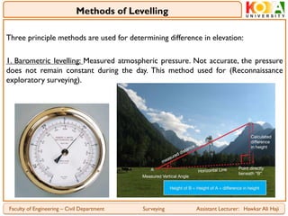
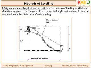
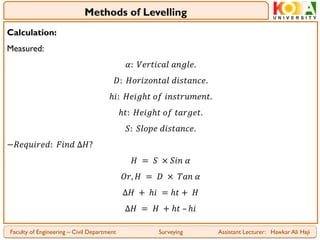
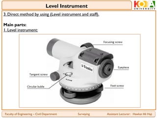
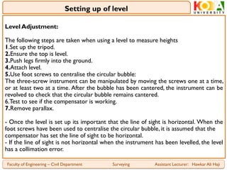
1. Koya University
Faculty of Engineering
Civil Engineering Department – 2nd Stage
Surveying (SUR5109)
Part 4: Levelling:
Definitions, Setting up and Booking
Assist. Lecturer: Hawkar Ali Haji
2. Levelling is the operation performed in surveying to determine and establish
elevations of points, to determine differences in elevation between points and for
control in construction works.
Terms and Definitions:
- A mean sea level is obtained by averaging the height of the surface of the sea for
all stages of tides for a long period (usually 19yrs). It is used as a reference datum.
- The elevation of a particular point is the vertical distance above or below a
reference datum.
- A level surface is a surface of constant elevation that is perpendicular to the
plumb line (vertical line) at every point. It is best represented by the surface of a
still body of a sea or an ocean if it is unaffected by tides.
- A level line is a curved line in a level surface all points of which are at equal
elevation. Every element of the level line is perpendicular to the plumb line.
Faculty of Engineering – Civil Department Surveying Assistant Lecturer: Hawkar Ali Haji
Introduction and Definitions
3. - A horizontal line is tangential to the level line at one point. For short distances
the level line and the horizontal line are assumed to be the same.
- Difference in elevation between two points is the vertical distance between the
level surfaces in which the points lie.
- Benchmark (BM) is a fixed point of known elevation above the datum. It is set as a
survey marker in order to provide a starting point for the determination of the
elevation of other points.A permanent object is used as a marker.
- Reduced level (RL) of a point is the height with respect to a datum.The term
elevation or altitude is synonymously used depending on the datum use.
- Datum: Is any surface to which elevations are referred.The mean sea level offered
a convenient datum world over, and elevations are commonly given as so much
above or below sea level.
Faculty of Engineering – Civil Department Surveying Assistant Lecturer: Hawkar Ali Haji
Definitions
4. - illustration of some terms on the figure below:
Faculty of Engineering – Civil Department Surveying Assistant Lecturer: Hawkar Ali Haji
Figure
5. Three principle methods are used for determining difference in elevation:
1. Barometric levelling: Measured atmospheric pressure. Not accurate, the pressure
does not remain constant during the day. This method used for (Reconnaissance
exploratory surveying).
Faculty of Engineering – Civil Department Surveying Assistant Lecturer: Hawkar Ali Haji
Methods of Levelling
6. 2.Trigonometry levelling (Indirect method): It is the process of levelling in which the
elevations of points are computed from the vertical angle and horizontal distances
measured in the field, it is called (Stadia levelling).
Faculty of Engineering – Civil Department Surveying Assistant Lecturer: Hawkar Ali Haji
Methods of Levelling
8. 3. Direct method by using (Level instrument and staff).
Main parts:
1. Level instrument:
Faculty of Engineering – Civil Department Surveying Assistant Lecturer: Hawkar Ali Haji
Level Instrument
9. Faculty of Engineering – Civil Department Surveying Assistant Lecturer: Hawkar Ali Haji
Level Instrument
10. Faculty of Engineering – Civil Department Surveying Assistant Lecturer: Hawkar Ali Haji
Types of Level
11. 2.Tripod:A tripod is a three-legged stand used to support a level.
3. Level staff:
- The vertical distance above or below the horizontal surface is read off a levelling
staff. It may be either telescope or folding extending to a length of 4m or 5m.
- The staff must be held vertically as any leaning of the staff will result in a level
reading which is too great. Reading can be taken by holding the staff lightly
between the palms of both hands on either sides of the staff.
- The material of level staff maybe steel, wood or aluminium.
Faculty of Engineering – Civil Department Surveying Assistant Lecturer: Hawkar Ali Haji
Level Instrument
12. Faculty of Engineering – Civil Department Surveying Assistant Lecturer: Hawkar Ali Haji
Level Staff
13. Level Adjustment:
The following steps are taken when using a level to measure heights
1.Set up the tripod.
2.Ensure the top is level.
3.Push legs firmly into the ground.
4.Attach level.
5.Use foot screws to centralise the circular bubble:
The three-screw instrument can be manipulated by moving the screws one at a time,
or at least two at a time. After the bubble has been cantered, the instrument can be
revolved to check that the circular bubble remains cantered.
6.Test to see if the compensator is working.
7.Remove parallax.
- Once the level is set up its important that the line of sight is horizontal. When the
foot screws have been used to centralise the circular bubble, it is assumed that the
compensator has set the line of sight to be horizontal.
- If the line of sight is not horizontal when the instrument has been levelled, the level
has a collimation error.
Faculty of Engineering – Civil Department Surveying Assistant Lecturer: Hawkar Ali Haji
Setting up of level
14. Terminologies:
- Bench mark (B.M.): Is permanent point with known elevation. They are bronze
disks or plugs set usually into vertical wall faces.
- Temporary bench mark (T.B.M.): Is a semi-permanent point of known elevation
(nail of street, corner of building, etc.).
- Back sight (B.S.): Is a rod reading taken a point of known elevation, to establish
the elevation of the instrument line of sight.
- The height of instrument (HI) is the elevation of the line of sight through the
level (𝑯𝑰 = 𝑩𝑴 + 𝑩𝑺).
- Foresight (F.S.): A rod reading taken on turning point, bench mark, or temporary
bench mark to determine its elevation (𝑯𝑰 − 𝑭𝑺 = 𝒆𝒍𝒆𝒗𝒂𝒕𝒊𝒐𝒏 𝒐𝒇 𝑻𝑷).
- Turning point (T.P.): Is a point temporary used to transfer an elevation.
- Intermediate foresight (I.S or I.F.S) is a rod reading taken at any other point
where the elevation is required (𝑯𝑰 − 𝑰𝑺 = 𝒆𝒍𝒆𝒗𝒂𝒕𝒊𝒐𝒏).
*Note:The rod must be vertical.
*Note: Lower reading will occur when rod is plumb (when the rod perpendicular to
the line of sight).
Faculty of Engineering – Civil Department Surveying Assistant Lecturer: Hawkar Ali Haji
Principles of Levelling
15. Faculty of Engineering – Civil Department Surveying Assistant Lecturer: Hawkar Ali Haji
Figure
16. Criteria for selecting levelling datum:
For all surveys a level line is chosen to which the elevation of all point is related to as
datum or datum surface. This can be any surface but the most commonly used datum
is mean sea level measured as ordinance datum. All points referred to ordinance
datum are said to have their height above ordinance datum. On many construction
and Civil Engineering sites, mean sea level is not often used as a datum for levelling.
Instead, a permanent feature of some sort is chosen.
Construction and use of bench marks:
Bench marks are permanent reference marks or points whose reduced levels are
accurately determined by levelling.They are classified into two namely:
1. Permanent or Ordinance bench marks (OBM), and
2.Temporary or transferred bench marks (TBM)
Faculty of Engineering – Civil Department Surveying Assistant Lecturer: Hawkar Ali Haji
Levelling
17. Ordinance bench marks (OBM) in figures:
Faculty of Engineering – Civil Department Surveying Assistant Lecturer: Hawkar Ali Haji
Figures
18. - The columns for booking the readings in a level book are same for both the methods
but for reducing the levels, the number of additional columns depends upon the method
of reducing the levels. Note that except for the change point, each staff reading is written
on a separate line so that each staff position has its unique reduced level. This remains
true at the change point since the staff does not move and the back sight from a forward
instrument station is taken at the same staff position where the fore sight has been taken
from the backward instrument station.
- There are two methods of booking of points from the observed staff readings:
1. Collimation Method or Height of Instrument (HI) method:
In this method each section highlighted by different shades is determined by adding the
elevation of the point to the back sight reading taken at that point. The H.I. remains
unchanged for all the staff readings taken within that section and therefore, the levels of
all the points lying in that section are reduced by subtracting the corresponding staff
readings, i.e., I.S. or F.S., from the H.C. of that section.
𝑯. 𝑰 = 𝑬𝒍𝒆𝒗. 𝑩. 𝑴. +𝑩. 𝑺.
𝑬𝒍𝒆𝒗. 𝑻. 𝑷 = 𝑯. 𝑰. −𝑭. 𝑺.
𝑬𝒍𝒆𝒗. 𝑷𝒐𝒊𝒏𝒕 = 𝑯. 𝑰. −𝑰. 𝑺.
Faculty of Engineering – Civil Department Surveying Assistant Lecturer: Hawkar Ali Haji
Methods of Booking or Reducing Level
19. 1. Standard levelling field book format (HI method):
Faculty of Engineering – Civil Department Surveying Assistant Lecturer: Hawkar Ali Haji
Field Book Format (HI Method)
𝑯𝑰 = 𝑩𝑺 + 𝑭𝑺 , 𝑬𝒍𝒆𝒗. = 𝑯𝑰 − 𝑭. 𝑺 𝒐𝒓 𝑰. 𝑺
𝒇𝒐𝒓 𝒄𝒉𝒆𝒄𝒌𝒊𝒏𝒈: 𝑩. 𝑺. − 𝑭. 𝑺. = 𝑹. 𝑳 𝒍𝒂𝒔𝒕 − 𝑹. 𝑳 𝒇𝒊𝒓𝒔𝒕
20. 2. Rise and Fall method:
In this method, the rises and the falls are found out for the points lying within each
section. Adding or subtracting the rise or fall to or from the reduced level of the
backward station obtains the level for a forward station.
𝚺 𝑩. 𝑺. – 𝚺 𝑭. 𝑺. = 𝚺 𝑹𝒊𝒔𝒆 – 𝚺 𝑭𝒂𝒍𝒍 = 𝑳𝒂𝒔𝒕 𝑹. 𝑳. – 𝑭𝒊𝒓𝒔𝒕 𝑹. 𝑳.
Standard levelling field book format (Rise and Fall method):
Faculty of Engineering – Civil Department Surveying Assistant Lecturer: Hawkar Ali Haji
Field Book Format (Rise and Fall) Method
21. Example (1):
Find the R.L. of the points from the following staff readings tabulated in the table
below?
Solution:
1. HI method:
𝐻𝐼 = 𝐵. 𝑆. + 𝐹. 𝑆.
𝐸𝑙𝑒𝑣. = 𝐻𝐼 – 𝐹. 𝑆. 𝑜𝑟 𝐼. 𝑆.
Faculty of Engineering – Civil Department Surveying Assistant Lecturer: Hawkar Ali Haji
Example
22. Faculty of Engineering – Civil Department Surveying Assistant Lecturer: Hawkar Ali Haji
Example
𝐹𝑜𝑟 𝑐ℎ𝑒𝑐𝑘𝑖𝑛𝑔: Σ 𝐵. 𝑆. – Σ 𝐹. 𝑆.
= 𝑅. 𝐿. 𝑙𝑎𝑠𝑡 − 𝑅. 𝐿. 𝑓𝑖𝑟𝑠𝑡
6.475 – 8.565 = 558.41 – 560.500
− 2.09 = −2.09 𝑂𝐾.
23. 2. Rise and fall method:
𝑹𝒊𝒔𝒆 𝒐𝒓 𝒇𝒂𝒍𝒍 = 𝑩. 𝑺. – 𝑭. 𝑺. = 𝑩. 𝑺. – 𝑰. 𝑺. = 𝑰. 𝑺. – 𝑰. 𝑺. = 𝑰. 𝑺. – 𝑭. 𝑺.
𝑹. 𝑳. = 𝑹. 𝑳. 𝒍𝒂𝒕𝒆𝒔𝒕 + (𝑹𝒊𝒔𝒆 + 𝒐𝒓 𝒇𝒂𝒍𝒍 −)
Faculty of Engineering – Civil Department Surveying Assistant Lecturer: Hawkar Ali Haji
Example
25. Example (2): Find the R.L. of the points from the following data, using HI method?
Solution:
𝑯𝑰 = 𝑩. 𝑺. + 𝑭. 𝑺.
𝑬𝒍𝒆𝒗. = 𝑯𝑰 – 𝑭. 𝑺. 𝒐𝒓 𝑰. 𝑺.
Faculty of Engineering – Civil Department Surveying Assistant Lecturer: Hawkar Ali Haji
Example
26. 𝑭𝒐𝒓 𝒄𝒉𝒆𝒄𝒌𝒊𝒏𝒈: 𝚺 𝑩. 𝑺. – 𝚺 𝑭. 𝑺. = 𝑹. 𝑳. 𝒍𝒂𝒔𝒕 – 𝑹. 𝑳. 𝒇𝒊𝒓𝒔𝒕
𝟖. 𝟒𝟏𝟖 – 𝟖. 𝟏𝟏𝟔 = 𝟖𝟑. 𝟓𝟎𝟎 – 𝟖𝟑. 𝟏𝟗𝟖 → 𝟎. 𝟑𝟎𝟐 = 𝟎. 𝟑𝟎𝟐 𝑶. 𝑲.
Faculty of Engineering – Civil Department Surveying Assistant Lecturer: Hawkar Ali Haji
Example
27. Example (3): The following consecutive readings were taken with a level and 5m staff,
on continuously sloping level at a common interval of 20m, (0.385, 1.030, 1.925, 2.825,
3.730, 4.685, 0.625, 2.005, 3.110, 4.185). The R.L. of the first point was 208.125 list these
reading in a levelling table, and calculated R.L. by rise and fall method, also find the
gradient of the line joining the first and last point?
Solution:
1.
𝑹𝒊𝒔𝒆 𝒐𝒓 𝒇𝒂𝒍𝒍 = 𝑩. 𝑺. – 𝑭. 𝑺. = 𝑩. 𝑺. – 𝑰. 𝑺. = 𝑰. 𝑺. – 𝑰. 𝑺. = 𝑰. 𝑺. – 𝑭. 𝑺.
𝑹. 𝑳. = 𝑹. 𝑳. 𝒍𝒂𝒕𝒆𝒔𝒕 + (𝑹𝒊𝒔𝒆 + 𝒐𝒓 𝒇𝒂𝒍𝒍 −)
Faculty of Engineering – Civil Department Surveying Assistant Lecturer: Hawkar Ali Haji
Example
29. Example (4): Complete the table below and then check your result arithmetically?
Solution:
1.
Faculty of Engineering – Civil Department Surveying Assistant Lecturer: Hawkar Ali Haji
Example