This document contains a cross section of subsurface geology along the Tug Fork region showing various rock units and their depths and thicknesses. It highlights several hydrocarbon producing zones within the Rome Trough of Northeastern Kentucky, from the Berea Sandstone oil play near the top to the Rogersville Shale gas opportunity near the bottom. It also notes various deep wells drilled in the area and locations of legacy and potential future exploration opportunities within formations like the Rogersville Shale and Conasauga Group.
Asymmetry in the atmosphere of the ultra-hot Jupiter WASP-76 b
NEKY Stacked Opportunities Rogersville Shale Berea Sandstone and More
1. 0 400
GR
0.45 -0.15
NPHI
2 3
RHOB
0 400
GR
2 3
RHOB
0 400
GR
0.45 -0.15
NPHI
2 3
RHOB
-
0 400
GR
2 3
RHOB
2
0
0
0
0 400
GR
0.45 -0.15
NPHI
2
0
0
0-2
0
0
0 400
GR
2 3
RHOB
0 400
GR
0.45 -0.15
NPHI
2 3
RHOB
45 -15
DPHI
-
Location
50 25 0 50 mi
A
A'
A''
A'''
A''''
E
E'
D
D'
C
C'
B
B'
1,000
0
75304 2356 2350 11665 90998 50748 83097 115976 45901 13288 32030 100771 128265 104509 120104 105270 128384 126080
<4.23 mi> <4.34 mi> <5.09 mi> <3.76 mi> <7.78 mi> <5.59 mi> <6.09 mi> <4.72 mi> <3.89 mi> <7.32 mi> <3.46 mi> <5.66 mi> <3.27 mi> <5.90 mi> <3.10 mi> <2.27 mi> <3.08 mi>
Boyd Co. Lawrence Co. Martin Co. Pike Co.
E
Rome
Formation
Pumpkin Valley
Shale
Rogersville
Shale
Maryville
Limestone
Nolichucky
Shale
M
aynardsville
Lim
estone
Copper Ridge
Dolomite
Rose Run
Sandstone
Beekmantown
Dolomite
St. Peter Sandstone
High Bridge Group
Trenton Limestone
Ordovician shale
Clinton shale
Rome
Sandstone
Upper Knox
Lower Knox
ConasaugaGroupKnoxGroup
Ordovician
carbonates
St. Peter Sandstone
Rose
Run
Sandstone
Precambrian
basement
Precambrian
basement
(estimated
from seismic
data)
Precambrian
basement
High Bridge Group
Trenton Limestone
Ordovician shale
Clinton Shale
KentuckyRiverFaultSystem
CreekFaultSystem
Structure
Pencil Cave bentonite
Rome Trough
Northwest Southeast
1,000
0
carbonates and
shales
Pennsylvanian
Mississippian
Devonian
shale
Depth relative to
sea level (ft)
Depth relative to
sea level (ft)
Approximate 2,500-ft depth
projected beneath river
?
?
?
PennsylvanianMississippian
Devonian
shale
Big Six
sandstone
Clinton
sandstone
Corniferous
Big Lime
Bedford
Sandstone/
Berea Shale
Borden
Formation
Corniferous
Big Six
sandstone
Clinton
sandstone
Big Lime
Borden
Formation
Pennington Formation
Ordovician
carbonates
Knox Group
Conasauga Group
ConasaugaGroupRomeFormation
Precambrian
basement
?
0 400
Regional unconformity
Sequestration interval
Formation level
Member and bed level
Correlation lines (dashed where inferred):
Faults
Arrow on downthrown side.
Gamma-ray log
intensity
No horizontal scale
EXPLANATION
Undiscussed
correlation
?
?
?
?
St. Peter Sandstone
Wells Creek Dolomite
Wells Creek Dolomite
Ohio Shale
Sunbury
Shale
Little
Lime
Sunbury
Shale
Bedford
Sandstone/
Berea Shale
Ohio
Shale
Approximate 2,500-ft depth
projected beneath river
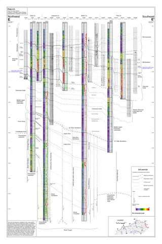
The rock unit intervals correlated in this cross section
are described in the accompanying report. Correlations
represent interpretations of approximate depths and
thicknesses of the units based on available data. Actual
depths and thicknesses may vary, especially in faulted
areas. It is also important to understand that an interval
described as a potential saline reservoir will not have
characteristics that allow injection and carbon storage
across the entire thickness shown. Potential storage
will only be possible in much smaller zones of those
intervals, as discussed in the accompanying report.
Plate 4.8.
Tug Fork cross section.
Chapter 4: Geologic Carbon Storage
(Sequestration) Potential in Kentucky
E'
K
e
n
t
u
c
k
y
R
iv
e
r
F
a
u
lt
S
y
s
t
e
m
ROGERSVILLE SHALE
535 Bsmt Contact
Cimarex Energy
SY #!
Rogersville Test
Oil and Gas
Chesapeake Test
Pmt# 111649
EQT Test
Pmt#111609
529 White
Oil Well
First Production
OIL & GAS
LOWER MARYVILLE
ROGERSVILLE SOURCED
Gas
O&G
O&G
Gas
O&G Production
Rumors &
Multiple
Flare Tests
Rogersville
Opportunity
NW Rome Trough
Cimarex
EQT
CHK
Exxon Smith-1
Highest TOC
EXXON
Smith#1
TOC 4.75
Rogersville
Section >700'
Rogersville
Section <600'
Rutledge Ls.
PCU
Maryville Ls.
Nolichucky Shale
Maynardsville Ls.
Stacked
Carbonates
>1.4 km3
?
Logged
CHK Northup #1H
Shallow to Deep well Transition
CHK#2?
Copper Ridge
Internal Reflector
Point Pleasant
>170'
-7477 Subsea
3 stages Unverified
Cimarex Walbridge #1H
IGC 535
IGC 542
Truncation ???
Truncation
Rogersville
Opportunity
KY Depocenter
PRODUCING FIELD
"MAVITY"
CLINTON GAS
APPROX 20'-25' Pay
BEREA OIL PLAY
TOC LOWER
HIGHER TOC
NEKY Stacked Opportunities.
Originally created to show stacked Co2 disposal possibilities, it represents a more complete strat. column allowing
highlighting of the numerous hydrocarbon producing zones stacked within the Rome Trough of NEKY in contrast to most
publications, edits are by Dexter Marsh based on well and or geophysical data tied to well ID 11665.
________________________________________________________________________________________________
Near the Top, the Berea Sandstone, Kentucky's Best Oil Play for the Second Year in a row and near the bottom
Kentucky's Newest the Rogersville Shale. and location of recent and legacy deep wells and new opportunities.
Modified from Tug Fork RI21_12_plate4_8 author-Michael Solis
Gordon SS Anomaly
Transect NS & EW
Correlates to
Middle Huron
EQT HZ Technologies Conasauga
3,514' thick no Differentiation
Rogersville 758' thick
New Kentucky State Record for Deepest Well
Rogersville 434' Thick Due To
Thinning Over Topography
Cimarex's-Conasauga Includes Only The Rogersville
Shale, Pumpkin Valley Shale and Rutledge LS per
Drillers Log. This Would make The Entire Conasauga
Section 4,895' Thick Not Counting The Maynardsville
Ls On Top Of The Nolichucky Shale
****Nomenclature is a Problem****