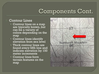
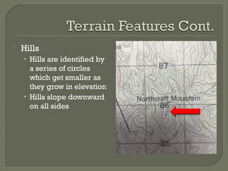
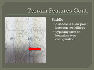
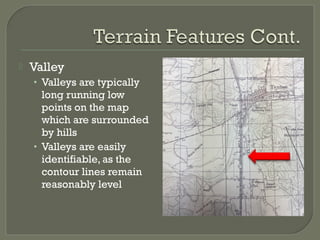
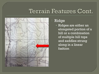
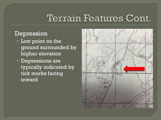
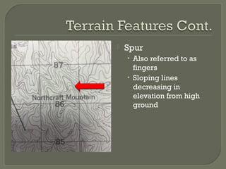
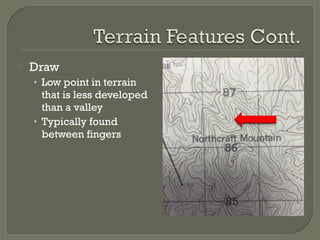
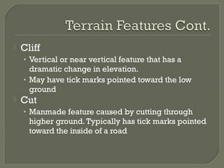
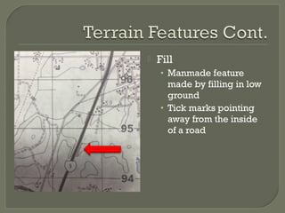
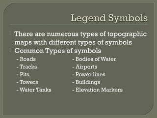
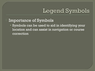
Deputy John Bounds
 To provide students with basic
knowledge of land navigation
 To provide students with the ability to
navigate using terrain association
 Following this period of instruction
students will:
• Identify the two basic components of a map
needed to navigate by terrain association
• Identify, at least, four terrain features found on a
topographic map
• Identify, at least, four man made feature symbols
found on a topographic map
 Legend
• The legend on a topographic map is commonly
found on the lower left corner of a map
• Depending on the map you use, there may be
anywhere from minor to significant differences
 Contour Lines
• Contour lines on a map
are typically brown, but
can be a variety of
colors depending on the
map
• Contour lines identify
elevation from sea level
• Thick contour lines are
found every fifth line and
indicate elevation by 100
meter increments
• Contour lines form
terrain features on the
map
 Hills
• Hills are identified by
a series of circles
which get smaller as
they grow in elevation
• Hills slope downward
on all sides
 Saddle
• A saddle is a low point
between two hilltops
• Typically form an
hourglass type
configuration
 Valley
• Valleys are typically
long running low
points on the map
which are surrounded
by hills
• Valleys are easily
identifiable, as the
contour lines remain
reasonably level
 Ridge
• Ridges are either an
elongated portion of a
hill or a combination
of multiple hill tops
and saddles strung
along in a linear
fashion
 Depression
• Low point on the
ground surrounded by
higher elevation
• Depressions are
typically indicated by
tick marks facing
inward
 Spur
• Also referred to as
fingers
• Sloping lines
decreasing in
elevation from high
ground
 Draw
• Low point in terrain
that is less developed
than a valley
• Typically found
between fingers
 Cliff
• Vertical or near vertical feature that has a
dramatic change in elevation.
• May have tick marks pointed toward the low
ground
 Cut
• Manmade feature caused by cutting through
higher ground.Typically has tick marks pointed
toward the inside of a road
 Fill
• Manmade feature
made by filling in low
ground
• Tick marks pointing
away from the inside
of a road
 There are numerous types of topographic
maps with different types of symbols
 Common Types of symbols
- Roads - Bodies of Water
- Tracks - Airports
- Pits - Power lines
- Towers - Buildings
- Water Tanks - Elevation Markers
 Importance of Symbols
• Symbols can be used to aid in identifying your
location and can assist in navigation or course
correction
 Performance Objectives
• Following this period of instruction students will:
 Identify two basic components of a map needed to
navigate by terrain association
 Identify at least four terrain features found on a
topographic map
 Identify at least four man made feature symbols found
on a topographic map
Navigation pp

Navigation pp

  • 1.
  • 2.
     To providestudents with basic knowledge of land navigation  To provide students with the ability to navigate using terrain association
  • 3.
     Following thisperiod of instruction students will: • Identify the two basic components of a map needed to navigate by terrain association • Identify, at least, four terrain features found on a topographic map • Identify, at least, four man made feature symbols found on a topographic map
  • 4.
     Legend • Thelegend on a topographic map is commonly found on the lower left corner of a map • Depending on the map you use, there may be anywhere from minor to significant differences
  • 5.
     Contour Lines •Contour lines on a map are typically brown, but can be a variety of colors depending on the map • Contour lines identify elevation from sea level • Thick contour lines are found every fifth line and indicate elevation by 100 meter increments • Contour lines form terrain features on the map
  • 6.
     Hills • Hillsare identified by a series of circles which get smaller as they grow in elevation • Hills slope downward on all sides
  • 7.
     Saddle • Asaddle is a low point between two hilltops • Typically form an hourglass type configuration
  • 8.
     Valley • Valleysare typically long running low points on the map which are surrounded by hills • Valleys are easily identifiable, as the contour lines remain reasonably level
  • 9.
     Ridge • Ridgesare either an elongated portion of a hill or a combination of multiple hill tops and saddles strung along in a linear fashion
  • 10.
     Depression • Lowpoint on the ground surrounded by higher elevation • Depressions are typically indicated by tick marks facing inward
  • 11.
     Spur • Alsoreferred to as fingers • Sloping lines decreasing in elevation from high ground
  • 12.
     Draw • Lowpoint in terrain that is less developed than a valley • Typically found between fingers
  • 13.
     Cliff • Verticalor near vertical feature that has a dramatic change in elevation. • May have tick marks pointed toward the low ground  Cut • Manmade feature caused by cutting through higher ground.Typically has tick marks pointed toward the inside of a road
  • 14.
     Fill • Manmadefeature made by filling in low ground • Tick marks pointing away from the inside of a road
  • 15.
     There arenumerous types of topographic maps with different types of symbols  Common Types of symbols - Roads - Bodies of Water - Tracks - Airports - Pits - Power lines - Towers - Buildings - Water Tanks - Elevation Markers
  • 16.
     Importance ofSymbols • Symbols can be used to aid in identifying your location and can assist in navigation or course correction
  • 17.
     Performance Objectives •Following this period of instruction students will:  Identify two basic components of a map needed to navigate by terrain association  Identify at least four terrain features found on a topographic map  Identify at least four man made feature symbols found on a topographic map